An online project under the direction of the CAPE ANN MUSEUM
Catalogue Entry
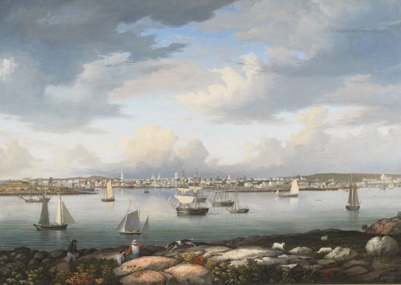
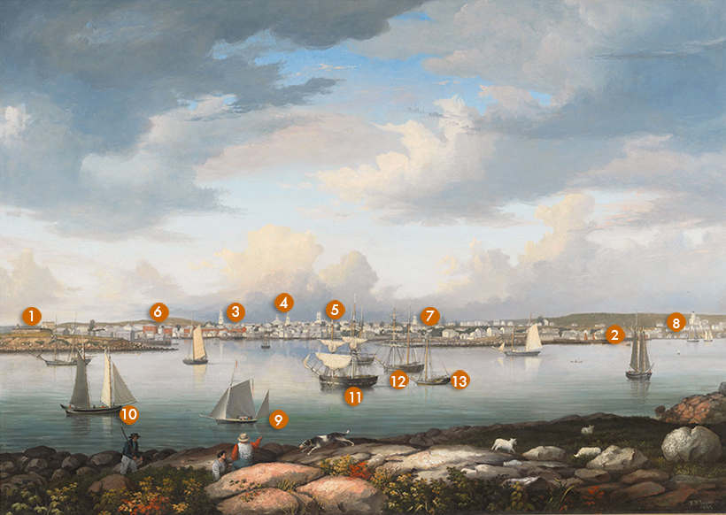
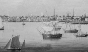
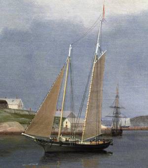
Lane painted Gloucester Harbor from Rocky Neck in 1844, just before the 1846 lithograph of Gloucester (his second) in which he drew the view of the harbor and city from Rocky Neck (see map below). Lane did three separate lithographs of Gloucester: View of the Town of Gloucester, Mass., 1836 (inv. 437), View of Gloucester, (From Rocky Neck), 1846 (inv. 92), and View of Gloucester, 1859 (inv. 446). They were all sold to townspeople by Lane himself for just a few dollars apiece. They track both the evolution of a growing Gloucester and of Lane as a lithographer: each successive print is larger, more detailed, and more skillful than the previous one.
In style and subject, this painting descends directly from Lane’s lithography work, particularly the town views. In these, he depicts panoramic vistas that have a map-like quality in their attempt to show every building and activity of a town. These views have a long tradition in printmaking, going back hundreds of years. They served as an affordable way for people to have a lasting image of where they lived and contributed to their appreciation of their town and to their sense of its identity.
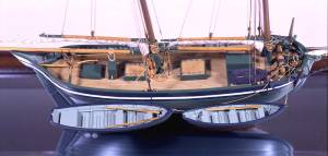
The southeastern shore of Gloucester's Inner Harbor was still very rural in Lane’s day, underlined here by the sheep and the man with the rifle and dog. The harbor is full of a wide variety of boats (see interactive feature, above), and the city shines in the distance under the sunlight. Every building is accurately drawn in its exact location, a mandatory practice for a lithographer of town views whose audience usually inhabited those same buildings. The sky is layered in light and dark clouds, another lithography practice used to differentiate the layers of sky when working in black and white. The foreground is Lane’s usual dark proscenium arch, with highlights on the foreground figure who points at the city as the sheep scamper off at an angle. Their direction is continued by the vessel on the right as it heads away in the shadow.
This painting shows Lane slowly growing out of his lithographer's techniques. He has included an astonishing level of detail but without a single focal point that provides a dominant emotion. While he has captured a clear crisp light, the painting has an overall flatness and static quality much like a colored lithograph, from which it is not far removed. In the next few years Lane would learn an immense amount about how to lead a viewer into and through a painting and how to use subtle color values to create atmosphere and recession in space.
– Sam Holdsworth
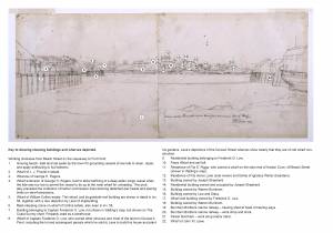
Gloucester Harbor from Rocky Neck, 1844 (inv. 14): A Visual Guide
Sketched from high ground on Rocky Neck, Lane’s composition elevated the background above the harbor traffic, providing clear views of both with minimal overlap. The resulting image presents a sweeping view of the harbor’s community and its shipping activity from west to east.
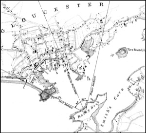
Harbor landmarks
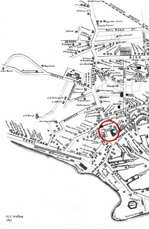
At far left, the grist mill - minus its vanes - of Ignatius Webber (1) rises above Fort Point and the remains of Fort Defiance (2), guard-post of Gloucester’s Inner Harbor from 1742 through the War of 1812. Just inside Fort Point was the wharf of John W. Lowe (3), a survivor from colonial times but still in use. Dominating the brick buildings on Front Street (now Main Street) is the Gloucester House (4), a hotel catering to an ever-growing clientele of summer visitors.
Parallel to Front Street was Middle Street, the setting for Gloucester’s most visible buildings, all of them churches. Largest was the Independent Christian Church (Universalist) (5), whose steeple served as an aid to navigation in the early 1800s for fishing and coastal trading vessels seeking anchorage. Next were the Congregationalist (7) and Unitarian (8) churches.
Above Middle Street was a parallel street whose west end was called High Street and the east end called Prospect Street. On the High Street end was a large school house (6). Between Front and Prospect Streets (a block beyond Middle Street) was Elm Street, where the Second Universalist Church (9) was located. Much farther to the eastward, at the end of Prospect Street, was the Methodist Church (10).
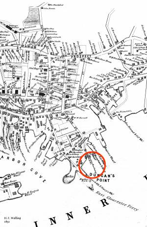
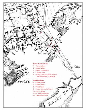
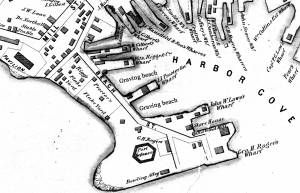
Returning to the waterfront, the wharves of Frederick Low (both numbered 11) in Harbor Cove (left) and Duncan’s Point (right). Just off the end of the latter wharf is Harbor Rock (12). Duncan’s Point (13) was largely owned by Frederick Low, including the land at its summit which he sold to Lane a few years later. At this same time, a waterfront parcel on the point was owned by Parker Burnham & Brother and used for shipbuilding and vessel repairs. This site, not visible in the painting, would become Gloucester’s first marine railway (see Inv. 29).
Vessels in port
Gloucester’s Inner Harbor – unlike its outer reaches – was shallow and difficult for berthing large vessels. This notwithstanding, Gloucester merchants played a prominent role in America’s trade with Surinam (Dutch Guiana) in the first half of the 19th century. This success led to a need for larger ships, ultimately forcing the merchants to move their ships and their warehouses to Boston (commuting to their offices by rail), ceding Gloucester Harbor to the fishing industry. This painting depicts the harbor while merchant vessels still arrived with goods from Surinam (and other countries as well). Gloucester’s fishing fleet, near the end of a long decline, is present in the form of schooners used for catching fish with hand lines. The “new” fishing methods (purse seining and dory trawling) were soon to be adopted, putting Gloucester in the forefront of the American fishing industry.
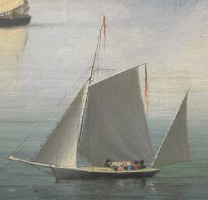
Surveying the part of the harbor used for anchorage and known as “The Stream", we see a coasting schooner (14) used to carry bulk cargos (lumber, hay and farm produce) to and from coastal communities, including major seaports. In the foreground is a pinky (15), a small fishing schooner type derived from colonial fishing vessels called “Chebacco boats”. The small yawl-rigged vessel (16) is a “party boat” used to take summer visitors sightseeing and fishing – a then-new industry destined for steady growth.
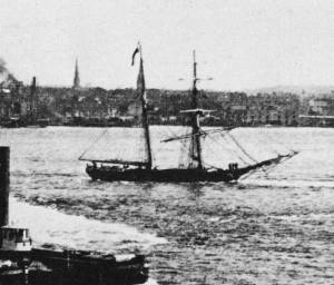
At center is a merchant brig (17) very likely used in the Surinam Trade and known locally as a “Surinam brig”. Astern is a hermaphrodite brig, or “half brig” (18), used in the coastal trade, but usually for longer passages when sailing farther offshore and setting square sails made for faster passages. The sloop (19) is a packet sloop, also used in the coastal trade, but well-kept and maintained, and used to carry passengers and higher-value goods between scheduled destination ports.
Looking toward the right margin, the inner harbor narrows and is very shallow at low tide. This area, called “Head of the Harbor’, provided anchorage for fishing vessels, wharves for unloading, and land for “flake yards” where fish dried on wooden racks called “fish flakes”. Lane depicted the constraints of this area very accurately in his painting “Gloucester Harbor” (Inv. 23). For “Gloucester Harbor from Rocky Neck”, he offers only a distant and partial view of this area, and only two distant views of the fishing schooners (20) that berthed there. Both vessels are “banks schooners” which fished with hand lines from their decks at the fishing banks off Canada or on Georges Bank east of Cape Cod.
In the coming decade, not only would Lane’s painting style change, but Gloucester Harbor’s industries and vessels would change with it, as Lane’s subsequent harbor views show so well.
– Erik Ronnberg
- Subject Types
: - Landscape Types
: - Seasons / Weather
: - Autumn »
- Vessel Types
: - Cape Ann Locales
: - Animals & People
: - Activities of People
: - Building Types
:
Historical Materials
Oil on canvas
34 x 45 3/4 in.
Cape Ann Museum, Gloucester, Mass., Gift of Mrs. Jane Parker Stacy (Mrs. George O. Stacy),1948 (1289.1a)
Detail of party boat.
Filed under: Gloucester Harbor, Inner / Harbor Cove » // Party Boat »
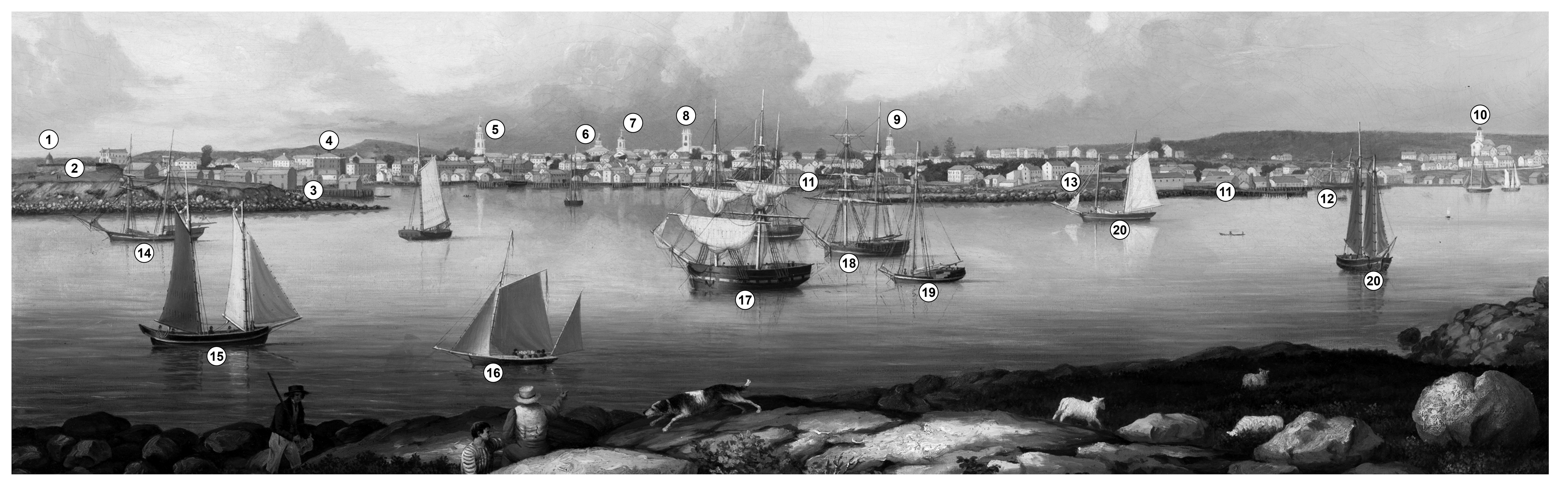
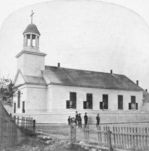
The old Baptist church appears in several Lane works. This was the first of three Baptist churches built on Pleasant Street. Baptists had been meeting on Cape Ann since 1808, originally in Sandy Bay (Rockport). But in 1830, a small group of Gloucester Baptists raised the funds to build a simple, unornamented, steeple-less white wooden building and chose this site near Franklin Square. Lane lithographs and paintings document the history of the building. In 1836, he showed it without a steeple. The building was improved in 1837 with the addition of a choir and the steeple, as seen in Lane's 1844 painting.
The building was not a church at the time of the painting of Gloucester Harbor in 1852, where it can be seen between the square four-spiked steeple of the First Parish Church and the mast of the closest, central boat. The Baptists, having recently built the large Italianate church seen just to the right in that 1852 painting, had sold the old Baptist church to Benjamin S. Corliss and other neighbors in 1850. Then in 1855, the Catholic community of Gloucester bought and moved the old church building around the corner to Prospect Street. The first Catholic mass had been held in 1849, in a private home, although the town hall was also available for masses. By 1855, the Catholic community established St. Ann's Parish, first in the old Baptist building (once again without a steeple, probably lost during the move from Pleasant Street), and then, when the current large stone church was built in 1876, this building became a school. It was replaced by the still-standing brick St. Ann's Parochial School in 1913.
– Sarah Dunlap (August, 2013)
Newspaper clipping
Cape Ann Advertiser
Collection of Fred and Stephanie Buck
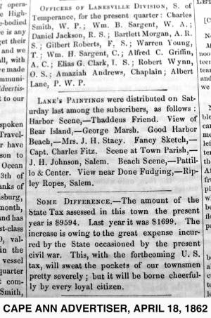
"LANE'S PAINTINGS were distributed on Saturday last among the subscribers, as follows: Harbor Scene, – Thaddeus Friend. View of Bear Island, – George Marsh. Good Harbor Beach, – Mrs. J. H. Stacy. Fancy Sketch, – Capt. Charles Fitz. Scene at Town Parish, – J. H. Johnson, Salem. Beach Scene, – Pattillo & Center. View near Done Fudging, – Ripley Ropes, Salem."
Also filed under: Alex Patillo Dry Goods » // Center & Co. » // Center, Henry » // Done Fudging » // Fitz, Capt. Charles » // Friend, Thaddeus » // Johnson, J. H. » // Marsh, George » // Newspaper / Journal Articles » // Patillo, Alex » // Ropes, Ripley » // Stacy, Mr. and Mrs. John Hancock »

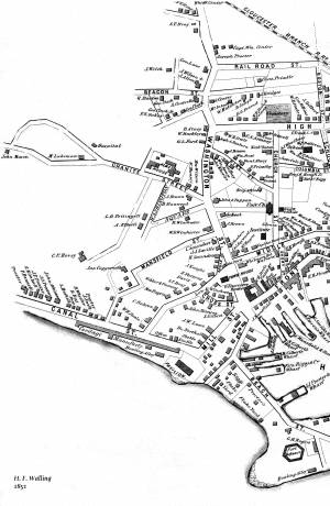
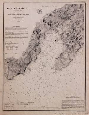
1851 44 x 34 in. Henry Francis Walling, Map of the Towns of Gloucester and Rockport, Essex Co. Massachusetts. Philadelphia, A. Kollner, 1851 Cape Ann Museum Library & Archive
"Map of the Towns of Gloucester and Rockport, Massachusetts. H.F. Walling, Civil Engineer. John Hanson, Printer. 1851. Population of Gloucester in 1850 7,805. Population of Rockport in 1850 3,213."
Also filed under: Burnham Brothers Marine Railway » // Duncan's Point » // Five Pound Island » // Flake Yard » // Gloucester Harbor, Inner / Harbor Cove » // Harbor Methodist Church (Prospect Street) » // Low (Frederick G.) wharves » // Pavilion Hotel » // Procter Brothers » // Ropewalk » // Vincent's Cove » // Western Shore »
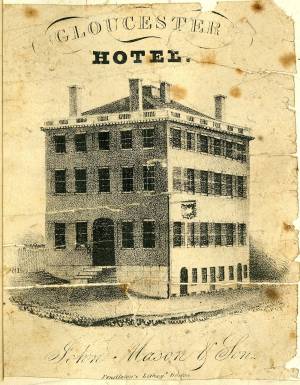
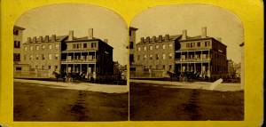
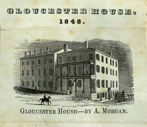
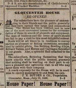
The Brick Houses were a cluster of buildings and a center of commerce and residence for wealthy local merchants. The brick hotel, the Gloucester House, was built by Col. James Tappan in 1810. It was four stories high, and scoffers of his grandiose hopes called it Tappan's Folly. It was from this hotel that stage coaches, before the 1847 extension of railroad to Gloucester, left for Boston every morning at 7:00 and returned every afternoon at 4:00. The hotel was opened year round, and was used by tourists and business people, as well as by local organizations. The John Mason family owned the hotel since the 1820s, and John's son Sidney Mason was the proprietor. Lane had perhaps already made an advertisement lithograph of this hotel in 1836. Sidney Mason also built the elaborate and luxurious summer Pavilion Hotel directly on the beach of the Outer Harbor. Both hotels are prominent in Gloucester Harbor, 1852 (inv. 38), and perhaps therefore the reason why Sidney commissioned Lane to paint that view. Col. Abijah Peabody, "one of the best landlords in the country," managed both hotels in 1852. Through the years, this brick hotel has also been named the Atlantic House, the Mason House, the Puritan House, and Blackburn Tavern. It still stands, offering a basement restaurant and upstairs public rooms.
The Gloucester House was the only brick building in the West End of town at the time of the disastrous fire on September 16, 1830, that wiped out blocks of wooden buildings and wharves. The brick buildings to the south and east of the Gloucester House replaced houses destroyed by that fire. Fire was an ever-present fear to Lane, who limped and walked with some difficulty. The story of the burning at sea of a merchant vessel on May 26, 1830, caught his attention, and the young artist, still Nathaniel Rogers Lane, painted Burning of the Packet Ship "Boston", 1830 (inv. 82) soon thereafter. A few months later, Lane, 26, lame and still living at home, experienced the panic and destruction of the September fire. His family's house on Middle Street was in danger, but survived intact. In 1849, after Lane returned to Gloucester from his lithography years in Boston, he built a fire-resistant stone house on Duncan's Point.
These brick houses were inhabited by wealthy merchants, owners of the wharves and businesses, next to the Town Landing and the intersection of Washington and Front Streets. Among them were Samuel Gilbert, James Mansfield, and Cyrus and Zachariah Stevens. Zachariah Stevens was the grandfather of Lane's friend and future executor, Joseph L. Stevens, Jr. Joseph lived with Zachariah from 1840 until his grandfather's death in 1846. Although still in Boston during this time, Lane frequently returned to his family and friends in Gloucester, and the two probably often met in the grandfather's house. Joseph and Lane made frequent trips to Joseph's parents' home in Castine, Maine.
Current address: West End of Main Street.
– Sarah Dunlap (August, 2013)
Cape Ann Museum Library & Archive
Stereo view
Also filed under: Historic Photographs »
Newsprint
Ad for Gloucester House
Courtesy of the American Antiquarian Society, Worcester, Mass.
See p. 4, column 2.
Also filed under: Newspaper / Journal Articles » // Party Boat »
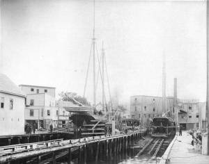
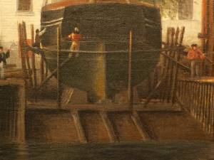
Lane was commissioned by his neighbor John Trask to paint a sign for his shop at the Burnham Brothers' Marine Railway, as seen in Three Master on the Gloucester Railways, 1857 (inv. 29). The railway, built in 1849-50, was a vital component of the ship building and repair trade, allowing large ships to be hauled out of the water to repair and clean the hulls. Originally there was just one railway, but a second was added due to increased demand. It consisted of a heavily reinforced timber structure anchored with iron spikes and topped with pairs of iron rails fitted with cast iron rollers. The vessel was hauled onto a wood cradle using a steam-powered winch, where it remained, blocked to prevent movement, for the duration of the repairs. Upgrades to the steam power plant can be observed when comparing the height of the smokestack in the painting with that in the later print View of Gloucester, 1859 (inv. 446). This may also be visible in drawings such as Gloucester from Fresh Water Cove, 1850s (inv. 144). Burnham’s was probably up-dating its steam power plant, not just to run power saws, but to power the steam winch which pulled the cradle with a ship on it up the rails.
Gloucester City Archives, Valuations for Harbor Parish, East Ward, 1851, 1852, 1853, 1854.
Valuations for wharf facilities and railway, 1851: $3,280; 1852: $4,800; 1853: $6,000; 1854: $9,000.
This steady and substantial growth is hard to explain in any other way than in the form of mechanical improvements, including steam-powered machinery to operate the hauling winch and power saws for a mill building for shipbuilding timber and planking. A note in the 1853 valuation, simply stating “new railway”, probably refers to the addition of a second railway, which would account for the significantly higher valuation in 1854.
Erik Ronnberg
Mounted print
8 x 10 in.
Cape Ann Museum Library & Archive
Railway at the tip of Duncan's Point. Vessels on the ways are "Isabell Leighton" and "Hattie B. West."
Also filed under: Duncan's Point »
Wood, cordage, acrylic paste, metal
~40 in. x 30 in.
Erik Ronnberg
Model shows mast of fishing vessel being unstepped.
Also filed under: Fishing » // Schooner (Fishing) »
1851 44 x 34 in. Henry Francis Walling, Map of the Towns of Gloucester and Rockport, Essex Co. Massachusetts. Philadelphia, A. Kollner, 1851 Cape Ann Museum Library & Archive
"Map of the Towns of Gloucester and Rockport, Massachusetts. H.F. Walling, Civil Engineer. John Hanson, Printer. 1851. Population of Gloucester in 1850 7,805. Population of Rockport in 1850 3,213."
Also filed under: Baptist Church (Old, First, 1830) (Pleasant Street) » // Duncan's Point » // Five Pound Island » // Flake Yard » // Gloucester Harbor, Inner / Harbor Cove » // Harbor Methodist Church (Prospect Street) » // Low (Frederick G.) wharves » // Pavilion Hotel » // Procter Brothers » // Ropewalk » // Vincent's Cove » // Western Shore »
Newsprint
From bound volume owned by publisher Francis Procter
Collection of Fred and Stephanie Buck
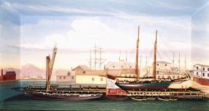
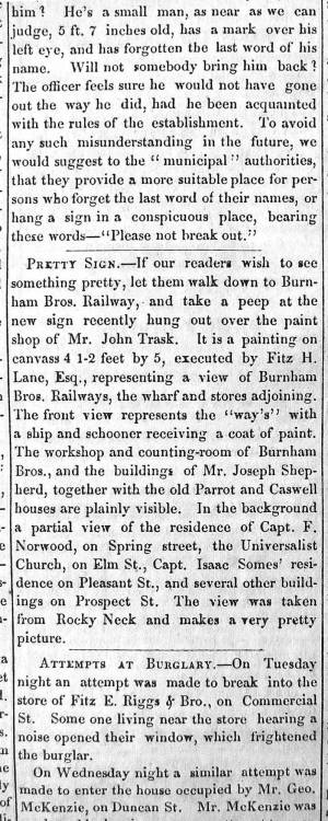
“PRETTY SIGN. – If our readers wish to see something pretty, let them walk down to Burnham Bros. Railway, and take a peep at the new sign recently hung out over the paint shop of Mr. John Trask. It is a painting on canvass 4 1-2 feet by 5, executed by Fitz H. Lane, Esq., representing a view of Burnham Bros. Railways, the wharf and stores adjoining. The front view represents the ‘way’s’ with a ship and schooner receiving a coat of paint. The workshop and counting-room of Burnham Bros., and the buildings of Mr. Joseph Shepherd, together with the old Parrot and Caswell houses are plainly visible. In the background a partial view of the residence of Capt. F. Norwood, on Spring street, the Universalist Church, on Elm St., Capt. Isaac Somes’ residence on Pleasant St., and several other buildings on Prospect St. The view was taken from Rocky Neck and makes a very pretty picture.”
Also filed under: Chronology » // John Trask Paint Store » // Newspaper / Journal Articles » // Trask, John »
Newspaper
Fire in the steam planing mill of Parker Burnham & Bros, foot of Water St. It spread through the block that included Ignatius Winter's sash-and-blind factory and John Trask's paint shop.
Also filed under: Newspaper / Journal Articles » // Trask, John » // Winter, Ignatius »

1865 41 x 29 inches Courtesy of the Massachusetts Archives Maps and Plans, Third Series Maps, v.66:p.1, no. 2352, SC1/series 50X
.
Also filed under: Collins's, William (estate wharf) » // Gloucester Harbor, Inner / Harbor Cove » // Maps » // Rogers's (George H.) wharves »
Newspaper obituary
Obituary of Parker Burnham, Esq.
Sawyer Free Library
Parker Burnham, Esq., the alderman from Ward 5, died at his residence on Spring Street on Thursday morning, of neuralgia of the heart, after a few days’ illness. Mr. Burnham was a native of Essex, son of the venerable Parker Burnham, recently deceased, but settled in Gloucester when quite a young man, and has been closely identified with the business interests of the town and city. On his removal to Gloucester, in connection with his brothers, Joseph B. and Elias, he established a shipyard, and the firm, under the name of Burnham Brothers, were successfully engaged in the building and repairing of vessels. Subsequently they built the first marine railways ever constructed in Gloucester, and in the business connected therewith Mr. Burnham remained to the time of his death. He was a man of marked character, honest in his dealings, kindly in his intercourse with his fellows, correct in his deportment and unassuming in his manners, devoting himself to his business without stepping aside to seek notoriety or distinction from his fellow citizens. In religion he was a Universalist and a regular attendant upon the services of the Independent Christian Church. In politics he was a Republican from the earliest formation of the party, and fully in accord with its principles, although he was elected upon the Board of Aldermen upon a democratic nomination, unsought, by a large majority. Since the organization of the city government Mr. Burnham has devoted a large portion of his time to the interests of the city, being constant in his attendance upon the meetings of the board and taking an active part in its deliberations. As chairman of the joint standing committee upon public property he had the oversight upon the Collins School House and the investigations concerning the remodeling of the City Hall; he was also a member of the committees upon finance and highways. His loss will be deeply felt by his associates in the city council, and by the community generally. His funeral took place on Saturday afternoon, and was attended by the members of the city council in a body.
Newspaper obituary
Obituary of Elias Burnham
Sawyer Free Library
Mr. Elias Burnham, whose severe illness was alluded to in our last issue, died at eleven o’clock on Saturday morning, having been unconscious for several hours before his death. He had been in his usual health until within a little over a week before his departure, when he was taken with an ill turn at the camp of his son, Mr. Elias P. Burnham, at West Gloucester, and grew rapidly worse until the end. Mr. Burnham was a native of Essex, being a son of Parker Burnham of that town. He was a ship carpenter by trade, and came to Gloucester over forty years ago with his brothers Parker and Joseph B., and engaged in the vessel building business on Pearce’s wharf, under the name of Burnham Brothers. Subsequently the firm purchased the Hough wharf, now owned by Walen & Son, and on the flats adjoining built the first marine railway ever constructed in Gloucester. To this business they afterwards added a planing mill, doing an extensive business. Mr. Joseph B. Burnham withdrew from the firm several years ago, carrying on for several years a planing mill on Pearce Street, and Mr. Parker Burnham, the oldest of the brothers, died in 1874, the firm of late years consisting of Elias, Elias P., son of Elias, and Parker H. and Enoch, sons of Parker. Identified for nearly half a century with the business interests of Gloucester, Mr. Burnham won a high place in the regard of his fellow citizens by his industrious habits, by the promptness and honesty which characterized all his business transactions, by his kindly social nature, his unassuming manners, and his respect for the rights and opinions of others. He was a prominent member of and liberal contributor to the support of the First Baptist Church, and his loss will be deeply felt by the members of that communion. He leaves a widow, son and daughter. His funeral took place from his late residence on Elm Street on Wednesday afternoon, his pastor, Rev. Dr. Morris officiating, and was largely attended.
Newspaper obituary
Obituary of Joseph Burnham, Esq.
Sawyer Free Library
Mr. Joseph Burnham, for many years a well known resident of this city, died very suddenly at his residence in West Gloucester on Tuesday, of paralysis, in the 67th year of his age. Although in somewhat feeble health of late years, he was able to keep about, and was out of doors the evening before his death. He was a son of Parker Burnham of Essex, and was formerly a member of the firm of Burnham Brothers (Parker, Joseph B. and Elias), who commenced ship- building in this city some two score years and more ago, and afterwards built the first marine railway in Gloucester and established a planing mill. Subsequently he retired from the firm and carried on a planing mill on Pearce Street for a number of years. He was also engaged in the remeasurement of our fishing fleet when the new tonnage law went into effect. Later, he purchased a farm in Rowley, but after a short residence there returned to Gloucester and took up his permanent residence at his summer camp at West Gloucester, where his death occurred.
He was an ingenious mechanic, steady, honest and industrious, and his sudden death will be deeply deplored by a large circle of friends. Mr. Burnham was a veteran Odd Fellow, having long been a member of Ocean Lodge, and was one of the seven charter members of Cape Ann Encampment, from which he withdrew about five years ago. His death is the second among the seven charter members of the Encampment, Capt. Edward Staten having been the first to depart from the earth life. The funeral of the deceased took place yesterday afternoon, Rev. Wm. H. Rider officiating, and was attended by the brethren of Ocean Lodge.

Detail views: marine railway and hauling cradle for vessel Wood rails, metal rollers, chain; wood cradle. Scale: ½" = 1' (1:24) Original diorama components made, 1892; replacements made, 1993. Cape Ann Museum, from Gloucester Chamber of Commerce, 1925 (2014.071)
A schooner is shown hauled out on a cradle which travels over racks of rollers on a wood and metal track.
Also filed under: Marine Railways » // Schooner (Coasting / Lumber / Topsail / Packet / Marsh Hay) »
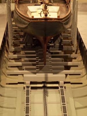
Wood rails, metal rollers, chain; wood cradle. Scale: ½" = 1' (1:24)
Original diorama components made, 1892; replacements made, 1993.
Cape Ann Museum, from Gloucester Chamber of Commerce, 1925 (2014.071)
Close up showing detail of rollers and hauling chain.
Also filed under: Marine Railways »
44 x 34 in.
John Hanson, Publisher
Cape Ann Museum Library & Archive
Also filed under: Marine Railways »
Oil on canvas
39 1/4 x 59 1/4 in.
Detail showing construction of marine railway. Details of the rollers and chain are obscured due to past cleaning efforts.
Also filed under: Marine Railways »
In 1828, the Methodists built the Harbor Methodist Church towards the eastern end of Prospect Street. This was also called the "Church on the Rock," for they followed Matthew's advice and planted it firmly on a granite outcropping. Lane's mother, the widow Sarah Haskell Lane, and his brother Edward Lane were members in high standing of this congregation. In fact, Edward was on its Board of Trustees and served as a steward and a "class leader." Even after the Riverdale Methodist Meetinghouse was built in 1838, on Washington Street overlooking Mill River, and even after the Lanes had sold their house on Middle Street and moved to the old Whittemore house near Oak Grove Cemetery, Edward Lane and his mother continued to be members of the Harbor Methodist Society. Lane’s mother died in 1853, but when Lane painted the 1852 Gloucester Harbor, she and her son were still active members. The ministers in 1851 and 1852 were Rev. Jarvis Wilson and Rev. Linus Fish; there were about 115 members. This building was used as the Harbor's Methodist meetinghouse until 1858, when the society bought and moved into another meetinghouse on Elm Street and sold this building to George H. Rogers for $300.
It is probable that the church is the Prospect Street Church mentioned in a petition to the Selectmen of Gloucester in January 1859, by citizens who wished that the Town would buy and convert it into a schoolhouse. The building was still standing in 1876 but no longer exists.
Methodism began in Europe in 1738, came to New York City in 1760, and to Gloucester in 1806. The first meetings in town were in the house of John Edney on the eastern edge of the Mill Pond in the Town Parish (now Riverdale). In 1823, Rev. George Pickering arrived in town and meetings were held in the old first parish meetinghouse at the Green, near the White-Ellery House.
Current address: Southeast corner of Prospect and Taylor Streets.
– Sarah Dunlap (August, 2013)
1851 44 x 34 in. Henry Francis Walling, Map of the Towns of Gloucester and Rockport, Essex Co. Massachusetts. Philadelphia, A. Kollner, 1851 Cape Ann Museum Library & Archive
"Map of the Towns of Gloucester and Rockport, Massachusetts. H.F. Walling, Civil Engineer. John Hanson, Printer. 1851. Population of Gloucester in 1850 7,805. Population of Rockport in 1850 3,213."
Also filed under: Baptist Church (Old, First, 1830) (Pleasant Street) » // Burnham Brothers Marine Railway » // Duncan's Point » // Five Pound Island » // Flake Yard » // Gloucester Harbor, Inner / Harbor Cove » // Low (Frederick G.) wharves » // Pavilion Hotel » // Procter Brothers » // Ropewalk » // Vincent's Cove » // Western Shore »
This was Charles F. Hovey's new house when Lane painted Gloucester Harbor from Rocky Neck, 1844 (inv. 14), the hilltop house on the horizon at the far left of the canvas, above the Fort. It is identified as the C.F. Hovey house on the 1851 Walling map and stood high above the outer Harbor, overlooking Gloucester's waterfront. The house that Charles Hovey built has been greatly altered by several owners over the years, but still commands an impressive view of the surrounding sea and land.
The brothers Charles Fox Hovey and George Otis Hovey, sons of Darius and Sarah, were born in Brookfield, Massachusetts. They first appeared in the Gloucester Assessor's Valuations in 1846, when Charles had a house, barn and land worth the substantial sum of $3,000, and George had land and an unfinished house worth $1,000, the beginnings of a vast estate on Dolliver’s Neck, Fresh Water Cove. The brothers enrolled in the Gloucester militia in 1847.
By 1851, both Charles and George lived in Boston, although they continued to own and pay taxes on their Gloucester houses. Charles was an abolitionist of note and a supporter of the women's rights convention. Charles F. Hovey died in Boston on April 28, 1859 of rheumatic gout. The posthumous $50,000 Hovey Fund was managed and allocated by the abolitionist and reformer, Wendell Phillips. George was a merchant and died in Gloucester on July 18, 1877.
Current address: 6 Hovey Street.
– Sarah Dunlap (January, 2014)
The Trinity Congregational Church, visible in Lane paintings such as Gloucester Harbor, 1852 (inv. 38), was built in 1831, during the time of the reconstruction of downtown Gloucester after the devastating 1830 fire. But this church was not built to replace one lost in that conflagration. It was built to house a large faction of the original First Parish Church (the four -pointed square tower visible in several paintings, just to the east on Middle Street) that was dismayed by the Unitarian drift of the parish. The rise of Unitarianism, and the hiring of new ministers with that leaning, caused those who continued to embrace the older Puritan, Calvinist, Congregational beliefs to secede and form their own church. It was a split between the more radical, newer element of the Unitarians and those who wished to maintain their older, Trinitarian roots.
The minister of the Trinitarian church in 1852 was James Aiken, who did not stay in town long. Nor did the building serve long as a church. In 1854, the building was sold, cut in half, and moved. Both halves now stand on Mason Street, facing south, across School Street from the Central Fire Station.
A second Trinity Congregational Church, with a steeple higher than any other in town, was immediately erected on same site in 1854. This 153-foot, octagonal steeple, visible in Gloucester from Steepbank, c.1855 (inv. 125) was removed in 1865. The church building was totally destroyed by fire in July 1979. A third church stands on the site today.
Current address: 70 Middle Street at the corner of School Street. However, the building that appears in pre-1854 Lane works was cut in half and moved to 2–8 Mason Street.
– Sarah Dunlap (August, 2013)
On Middle St., the building of the new Orthodox Church will soon be commenced. …we understand that the church when completed, will be the finest in the country. It is to be surmounted by a steeple higher than any other in town, and will be a prominent land mark. The contractors, Messrs. Smith & Babson, are young and enterprising mechanics, and will spare no pains to render the completion of the edifice as perfect and handsome as can be accomplished. The old church having been cut in two, and moved back on Mason Street, is being fitted up, and will be made into two large double dwelling houses. Another building has also been moved into this street and is being fitted up for a dwelling house.
The Union School was built in 1823, as one of Gloucester's public district schools in 1823. It was situated on land lying between High Street (now called Prospect) and Columbia Streets near what is now the site of McPherson Park. (In the Walling map below it is in the middle of the block bordered by Church, Columbia, High, and School Streets.) While Lane went to school, the number of such district schools increased from eleven in 1804 to twenty-three by 1840. This Union School was one of them, and stood for the rest of Lane's life. The land, given by Mrs. Abigail Collins, was the southern portion of the present lot, being that portion closer to Columbia Street. In the 1860s, more land was purchased and in 1864 the Collins School was built closer to Prospect Street. The original Union School, by now called the "old Collins School House," was not torn down until after Lane’s death, when it was auctioned off and purchased by F.E. Riggs in November 1865, along with its blocking and lumber and the privy, for $1,152. John W. Lurvey, a carpenter who lived around the corner on Washington Street, was hired to prepare it for sale, and he received $16.50 for six days' work. The second Collins School, was demolished in 1947. McPherson Park, an elderly housing complex, opened in 1976 and still stands on this lot.
Address: 31 Prospect Street, known as High Street in Lane's time.
– Sarah Dunlap (May, 2014)
44 x 34 in.
Henry Francis Walling, Map of the Towns of Gloucester and Rockport, Essex Co. Massachusetts. Philadelphia, A. Kollner, 1851
Cape Ann Museum Library & Archive
"Map of the Towns of Gloucester and Rockport, Massachusetts. H.F. Walling, Civil Engineer. John Hanson, Publisher. 1851. Population of Gloucester in 1850 7,805. Population of Rockport in 1850 3,213."
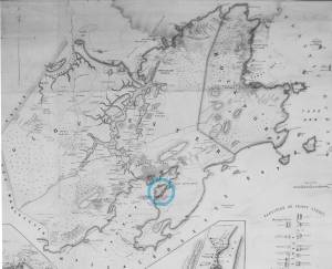
Segment of Harbor Village portion of map showing Lane-Winter property on Duncan's Point.
Also filed under: Duncan's Point » // Maps » // Winter, Ignatius »
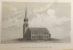
The First Parish (Unitarian) meeting house, located on Middle Street, was a wooden framed, clapboard-sheathed structure with a distinctive four-pointed neo-Gothic inspired tower. It was built in 1828, as the First Parish Church, replacing an earlier structure built on the site in 1738, when the "first" parish moved to the Harbor from its original location on the Annisquam River near where the Rte. 128 Grant Circle now is laid out. The parish system dated from the Massachusetts Bay Colony times, when both religious and civic business was conducted in the parish meetinghouses. This 1828 building was a descendant of that system. It became the Unitarian Church gradually in the 1830s, when more traditional members separated, formed their own society and built the Congregational/Trinitarian Church two doors to the west on Middle Street. The Universalists, Methodists, and Baptists had already seceded and formed their own congregations, and the parish system was at an end.
The Unitarian William Mountford, newly arrived from England, preached in this church from 1850 to 1853. In 1852, a new organ was dedicated on July 4, and Rev. Mountford was installed formally on August 3. (1) It is not known if Lane himself was a member of this or any church, but he shared several traits with Mountford: they both walked with a limp, and they were both interested in Spiritualism. Mountford moved to Boston in 1853 to pursue Transcendentalism and Spiritualism, and seldom returned to Gloucester. But he did come back in August, 1865, to officiate at Fitz Henry Lane's funeral, although Rev. Robert P. Rogers was minister at the time. It was from this church that Lane's body made its final journey to the Oak Grove Cemetery, where he was buried in the family plot of Joseph L. Stevens, Jr.
This building remained the Unitarian Church through the 1940s; however, the congregation had dwindled significantly and was no longer able to maintain the structure. The Gothic steeple was removed during this time. By 1950, the few remaining congregants were meeting with the Universalists further along Middle Street and the assets of the church were divided up: the church silver, made by Paul Revere, went to the Cape Ann Museum; endowment funds went to the Unitarian headquarters in Boston and the meeting house was sold to the local Jewish community who transformed it into Temple Ahavat Achim. Another victim of fire, it was destroyed in the conflagration that began in the next-door Lorraine Apartments on a wintry night of December, 2007.
Current Address: 86 Middle Street, site of Temple Ahavat Achim.
– Sarah Dunlap
Reference:
1. Babson, History of Gloucester, p. 497.
Watercolor on paper
Cape Ann Museum Library & Archive
Also filed under: Low (Frederick G.) wharves » // Maps »
c.1868 Glass plate negative
Also filed under: Lane's Stone House, Duncan's Point » // Residences »
Stereograph card Cape Ann Museum Library & Archive
Also filed under: Historic Photographs » // Procter Brothers »
44 x 34 in.
Henry Francis Walling, Map of the Towns of Gloucester and Rockport, Essex Co. Massachusetts. Philadelphia, A. Kollner, 1851
Cape Ann Museum Library & Archive
"Map of the Towns of Gloucester and Rockport, Massachusetts. H.F. Walling, Civil Engineer. John Hanson, Publisher. 1851. Population of Gloucester in 1850 7,805. Population of Rockport in 1850 3,213."
See p. 498. This shows the First Parish Meeting House before it was rebuilt in 1828.
Also filed under: Babson History of the Town of Gloucester »

Stereograph card
Cape Ann Museum Library & Archive
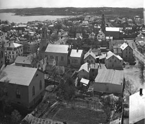
View from top of Unitarian Church on Middle Street looking southeast, showing the Fort and Ten Pound Island. Tappan Block and Main Street buildings between Center and Hancock in foreground.
Also filed under: Fort (The) and Fort Point » // Ten Pound Island »
Cape Ann Museum Library & Archive
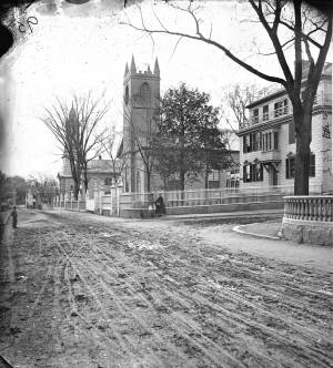
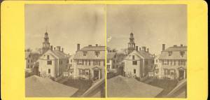
Middle Street looking west. At the corner of Dale Avenue is the Sanders-Davidson house, later Sawyer Free Library. Also shown: Unitarian Church, Congregational Church.
Also filed under: Sanders-Davidson House »
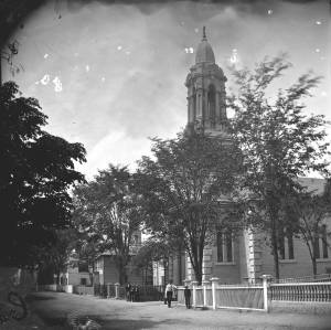
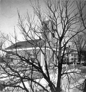
This large steepled building is Gloucester's Universalist Church. Universalism had found fertile ground here in Gloucester before the Revolution under the leadership of John Murray, who brought the teachings of James Relly from England in 1774. With adherents among the town's leaders such as Winthrop Sargent and his daughter, Judith Sargent Stevens Murray, it spread and flourished. The Gloucester adherents to Universalism refused to support quasi-governmental parish churches, specifically the First Parish in the Harbor district, and, speaking as well for all other non-parish churches, their dissent led to the Constitutional separation of Church and State. The first Universalist meetings were held on Sargent property at what was then Spring and Water Streets, now near the corner of Main and Duncan Streets. In 1805, under a new minister, Thomas Jones, this towering structure of the Universalist Church was erected by the local architect and builder, Jacob Smith.
The church's interior and foundation have been changed slightly since Lane's 1852 painting: in the 1860s, the foundation was raised seven feet to allow for a hall in the basement, and the lovely curved vestry staircases were installed. But the steeple remains as Smith, and Lane, saw it. It still houses a Paul Revere bell—for many years the only large bell in town. In 1852, this was the tallest structure on the skyline and a beacon to returning vessels. Its height was increased by the addition of a 'blind story' to the stack of belfry, lantern and cupola.
In 1852, the minister of the church was Amory D. Mayo, but in three years William R.G. Mellen would occupy the pulpit. He and his brother Charles Mellen were both Universalist ministers. Charles' wife was Mary Blood Mellen, Lane's student and copyist, but Charles was never a minister in Gloucester.
Current address: 50 Middle Street.
– Sarah Dunlap (May, 2014)
Cape Ann Museum Library & Archive
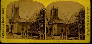
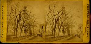
Stereo view of a front and side view of the Church, taken when there was no foliage upon the trees. Church street is also given throughout its length.
Also filed under: Historic Photographs »
1865 Stereograph card Cape Ann Museum Library & Archive
Also filed under: Historic Photographs »
44 x 34 in.
Henry Francis Walling, Map of the Towns of Gloucester and Rockport, Essex Co. Massachusetts. Philadelphia, A. Kollner, 1851
Cape Ann Museum Library & Archive
"Map of the Towns of Gloucester and Rockport, Massachusetts. H.F. Walling, Civil Engineer. John Hanson, Publisher. 1851. Population of Gloucester in 1850 7,805. Population of Rockport in 1850 3,213."

1834–35 24 x 38 in. Gloucester City Archives
"Drawn on a scale of one hundred feet to an inch. By John Mason 1834–45 from Actual Survey showing every Lott and building then standing on them giving the actual size of the buildings and width of the streets from the Canal to the head of the Harbour & part of Eastern point as farr as Smith's Cove and the Shore of the same with all the wharfs then in use. Gloucester Harbor 1834–35."
This map is especially helpful in showing the wharves of the inner harbor at the foot of Washington Street.
Also filed under: Dale, Eben B. » // Eastern Railroad » // Flake Yard » // Gloucester Harbor, Inner / Harbor Cove » // Hough, Benjamin Kent » // Maps » // Pavilion (Publick) Beach » // Ropewalk » // Sawyer, Samuel » // Town / Public Landings »

4 x 6 in.
Cape Ann Museum, Benham Collection
George Steele sail loft, William Jones spar yard, visible across harbor. Photograph is taken from high point on the Fort, overlooking business buildings on the Harbor Cove side.
Also filed under: Fort (The) and Fort Point » // Gloucester Harbor, Inner / Harbor Cove » // Town House » // Waterfront, Gloucester »
Through the years, this point and its fortifications had many names: Watch House Point, the Old Battery, Fort Defiance, Fort Head, and now just "The Fort." In 1793, Fort Defiance was turned over to the young United States government and was allowed to deteriorate. During the War of 1812 it was described as being "in ruins," and any remaining buildings burned in 1833. It was resuscitated in the Civil War and two batteries of guns were installed. The City of Gloucester did not regain ownership of the land until 1925.
The first fortifications on this point, guarding the entrance to the Inner Harbor, were put up in the 1740s, when fear of attack from the French led to the construction of a battery armed with twelve-pounder guns. Greater breastworks were thrown up in 1775, after Capt. Lindsay and his sloop-of-war the "Falcon" attacked the unprepared town. They were small and housed only a few cannon and local soldiers. Several other fortifications were at various times erected around the harbor: Fort Conant at what is now Stage Fort Park, another on Duncan's Point (near site of Lane's house) and the Civil War fort on Eastern Point. None of these preparations was ever called upon to actually defend the town.
Lane during his lifetime created a long series of images of the point and the condition of its fortifications. In 1832 there were still buildings standing, and the point had not yet been used for major wharves and warehouses. By the time of his painting Gloucester Harbor, 1852 (inv. 38), one can see that the earthwork foundation, but no superstructures, survived.
– Sarah Dunlap

1860 In John J. Babson, History of the Town Gloucester (Gloucester, MA: Procter Brothers, 1860) Cape Ann Museum Library & Archives, Gloucester, Mass.
See p. 474.
View related catalogue entries (4) »
Also filed under: Babson History of the Town of Gloucester » // Chebacco Boat / Dogbody / Pinky » // Gloucester Harbor, Inner / Harbor Cove » // Gloucester, Mass. - "Ten Pound Island Light » // Schooner (Coasting / Lumber / Topsail / Packet / Marsh Hay) » // Ten Pound Island »
Newsprint
Gloucester Telegraph
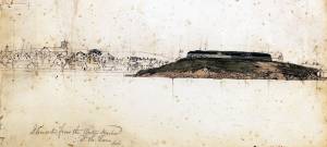
About picture of Old Fort hanging in the Gloucester Bank: "This picture is chiefly of interest on account of its preserving so accurately the features of a view so familiar to many of our citizens and which can never exist in reality."
Also filed under: Chronology » // Gloucester Bank » // Gloucester, Mass. – Gloucester Bank » // Newspaper / Journal Articles »

24 x 38 in.
Gloucester City Archives
"Drawn on a scale of one hundred feet to an inch. By John Mason 1834–45 from Actual Survey showing every Lott and building then standing on them giving the actual size of the buildings and width of the streets from the Canal to the head of the Harbour & part of Eastern point as farr as Smith's Cove and the Shore of the same with all the wharfs then in use. Gloucester Harbor 1834–35."
This map is especially useful in showing the Fort.
Also filed under: Flake Yard » // Maps » // Mason, John » // Pavilion (Publick) Beach » // Town / Public Landings »

44 x 34 in.
John Hanson, Publisher
Cape Ann Museum Library & Archive
"Map of the Towns of Gloucester and Rockport, Massachusetts. H.F. Walling, Civil Engineer. John Hanson, Publisher. 1851. Population of Gloucester in 1850 7,805. Population of Rockport in 1850 3,213."
Also filed under: Low (Frederick G.) wharves » // Maps » // Rogers's (George H.) wharves » // Town / Public Landings » // Waterfront, Gloucester » // Windmill »
Newsprint
Cape Ann Advertiser
Cape Ann Museum Library & Archive
"Fort Hill was occupied by Capt. H. C. Mackay and John Lowe, as a flake-yard, and there were but one or two old fish-houses in the vicinity. The improvements at this point during the last fifteen years have left no traces of its former appearance, almost every landmark having been obliterated. A very good idea of the place as it then appeared may be obtained from the painting of Fitz H. Lane, Esq., now on exhibition at the Reading Room under the Gloucester Bank."
Also filed under: Gloucester Bank » // Newspaper / Journal Articles »
Newspaper
Gloucester Telegraph
"By the will of the late Fitz H. Lane, Esq., his handsome painting of the Old Fort, Ten Pound Island, etc., now on exhibition at the rooms of the Gloucester Maritime Insurance Co., was given to the town... It will occupy its present position until the town has a suitable place to receive it."
Also filed under: Funeral & Burial » // Gloucester, Mass. – Marine Insurance Company » // Newspaper / Journal Articles » // Ten Pound Island »
Newsprint
Gloucester Telegraph
At the dedication of the Town House, speaker, "read the following letter:
To the Selectmen of Gloucester: / Gents: The will of our late Townsman, Fitz. H. Lane, contains this provision: / I give to the inhabitants of the Town of Gloucester, the picture of the Old Fort, to be kept as a memento[sic] of one of the localities of olden time; the said picture now hanging in the Reading Room under the Gloucester Bank, and to be there kept until the Town of Gloucester shall furnish a suitable and safe place to hang it. / The original sketch was taken twenty-five years ago, but the boats and vessels introduced are those of a quarter of a century earlier still. The painting was executed in 1859, six years before his decease."
Also filed under: Documents / Objects » // Newspaper / Journal Articles » // Town House »
Stereograph card
Cape Ann Museum Library & Archive
View from top of Unitarian Church on Middle Street looking southeast, showing the Fort and Ten Pound Island. Tappan Block and Main Street buildings between Center and Hancock in foreground.
Also filed under: Ten Pound Island » // Unitarian Church / First Parish Church (Middle Street) »

1876 Photograph Cape Ann Museum Library & Archive
Ignatius Weber's windmill (now defunct) is shown.
Also filed under: Flake Yard » // Gloucester Harbor, Inner / Harbor Cove » // Historic Photographs » // Rogers's (George H.) wharves » // Schooner (Fishing) » // Waterfront, Gloucester » // Windmill »
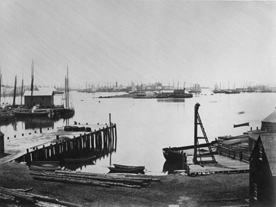
The northeast quarter of Gloucester Harbor is an inlet bounded by Fort Point and Rocky Neck at its entrance. It is further indented by three coves: Harbor Cove and Vincent’s Cove on its north side, and Smith’s Cove on its south side. The shallow northeast end is called Head of the Harbor. Collectively, this inlet with its coves and shallows is called Inner Harbor.
The entrance to Inner Harbor is a wide channel bounded by Fort Point and Duncan’s Point on its north side, and by Rocky Neck on its south side. From colonial times to the late nineteenth century, it was popularly known as “the Stream” and served as anchorage for deeply loaded vessels for “lightering” (partial off-loading). Subsequently it was known as “Deep Hole.”
Of Inner Harbor’s three coves, Harbor Cove (sometimes called “Old Harbor” in later years) was the deepest and most heavily used by fishing vessels in the Colonial Period, and largely dominated by the foreign trade in the first half of the nineteenth century. Its shallow bottom was the undoing of the foreign trade, as larger vessels became too deep to approach its wharves, and the cove returned to servicing a growing fishing fleet in the 1850s.
Vincent’s Cove, a smaller neighbor to Harbor Cove, was bare ground at low tide, and mostly useless for wharfage. Its shoreline was well suited for shipbuilding, and the cove was deep enough at high tide for launching. Records of shipbuilding there prior to the early 1860s have to date not been found.Smith’s Cove afforded wharfage for fishing vessels at its east entrance, as seen in Lane’s lithograph View of the Town of Gloucester, Mass., 1836 (inv. 86). The rest of the cove saw little use until the expansion of the fisheries after 1865.
The Head of the Harbor begins at the shallows surrounding Five Pound Island, extending to the harbor’s northeast end. Lane’s depiction of this area in Gloucester Harbor, 1847 (inv. 23) shows the problems faced by vessel owners at low tide. Despite the absence of deep water, this area saw rapid development after 1865 when a thriving fishing industry needed waterfront facilities, even if they were accessible only at high tide.
– Erik Ronnberg

c.1870 Cape Ann Museum Library & Archive (2013.068)
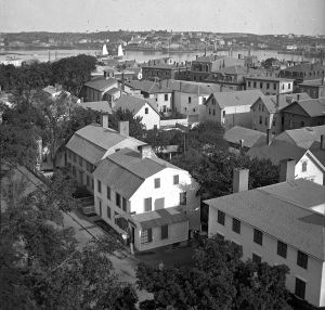
Schooner fleet anchored in the inner harbor. Looking east from Rocky Neck, Duncan's Point wharves and Lane house (at far left), Sawyer School cupola on Friend Street.
Also filed under: Duncan's Point » // Historic Photographs » // Schooner (Fishing) » // Waterfront, Gloucester »
1876 Photograph Cape Ann Museum Library & Archive
Also filed under: Historic Photographs » // Schooner (Fishing) » // Waterfront, Gloucester »
1851 44 x 34 in. Henry Francis Walling, Map of the Towns of Gloucester and Rockport, Essex Co. Massachusetts. Philadelphia, A. Kollner, 1851 Cape Ann Museum Library & Archive
"Map of the Towns of Gloucester and Rockport, Massachusetts. H.F. Walling, Civil Engineer. John Hanson, Printer. 1851. Population of Gloucester in 1850 7,805. Population of Rockport in 1850 3,213."
Also filed under: Baptist Church (Old, First, 1830) (Pleasant Street) » // Burnham Brothers Marine Railway » // Duncan's Point » // Five Pound Island » // Flake Yard » // Harbor Methodist Church (Prospect Street) » // Low (Frederick G.) wharves » // Pavilion Hotel » // Procter Brothers » // Ropewalk » // Vincent's Cove » // Western Shore »
4 x 6 in.
Cape Ann Museum, Benham Collection
George Steele sail loft, William Jones spar yard, visible across harbor. Photograph is taken from high point on the Fort, overlooking business buildings on the Harbor Cove side.
Also filed under: Fort (The) and Fort Point » // Town House » // Universalist Church (Middle and Church Streets) » // Waterfront, Gloucester »


1834–35 Lithograph 24 x 38 in. Gloucester City Archives
"Drawn on a scale of one hundred feet to an inch. By John Mason 1834–45 from Actual Survey showing every Lott and building then standing on them giving the actual size of the buildings and width of the streets from the Canal to the head of the Harbour & part of Eastern point as farr as Smith's Cove and the Shore of the same with all the wharfs then in use. Gloucester Harbor 1834–35."
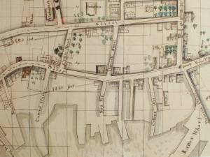
This map shows the location of F. E. Low's wharf and the ropewalk. Duncan's Point, the site where Lane would eventually build his studio, is also marked.
The later notes on the map are believed to be by Mason.
Also filed under: Duncan's Point » // Low (Frederick G.) wharves » // Low, Capt. Frederick Gilman » // Maps » // Mason, John » // Residences » // Ropewalk » // Somes, Capt. John »
44 x 34 in.
Henry Francis Walling, Map of the Towns of Gloucester and Rockport, Essex Co. Massachusetts. Philadelphia, A. Kollner, 1851
Cape Ann Museum Library & Archive
"Map of the Towns of Gloucester and Rockport, Massachusetts. H.F. Walling, Civil Engineer. John Hanson, Publisher. 1851. Population of Gloucester in 1850 7,805. Population of Rockport in 1850 3,213."
Segment of Harbor Village portion of map showing Collins' and other wharves in the Inner Harbor.
Also filed under: Graving Beach »

Collection of Erik Ronnberg
View related catalogue entries (2) »
Also filed under: Dolliver's Neck » // Fresh Water Cove » // Gloucester Harbor, Outer » // Maps »
1865 41 x 29 inches Courtesy of the Massachusetts Archives Maps and Plans, Third Series Maps, v.66:p.1, no. 2352, SC1/series 50X
.
Also filed under: Burnham Brothers Marine Railway » // Collins's, William (estate wharf) » // Maps » // Rogers's (George H.) wharves »
Photograph in The Illustrated Coast Pilot with Sailing Directions. The Coast of New England from New York to Eastport, Maine including Bays and Harbors, published by N. L. Stebbins, Boston
Also filed under: Beacons / Monuments / Spindles »
Stereograph card Cape Ann Museum Library & Archive
Also filed under: Gloucester – City Views » // Historic Photographs »
c.1870s Stereograph card Cape Ann Museum Library & Archive
From East Gloucester looking towards Gloucester.
Also filed under: Gloucester – City Views » // Historic Photographs »
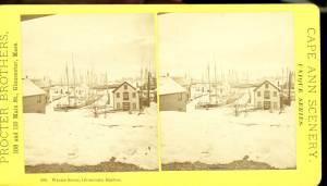
1876 Stereograph card Cape Ann Museum Library & Archive
Stereo view showing Gloucester Harbor after a heavy snowfall
Also filed under: Historic Photographs » // Waterfront, Gloucester »
Cape Ann Museum Library & Archive
Five Pound Island and Gloucester inner harbor taken from the top of Hammond Street building signs in foreground are for Severance, Carpenter and Crane, and Cooper at Clay Cove.
Also filed under: Five Pound Island »
1852
Oil on canvas
28 x 48 1/2 in.
Cape Ann Museum, Gloucester, Mass., Deposited by the City of Gloucester, 1952. Given to the city by Mrs. Julian James in memory of her grandfather Sidney Mason, 1913 (DEP. 200)
Detail of fishing schooner.
Also filed under: Schooner (Fishing) »
Oil on canvas
34 x 45 3/4 in.
Cape Ann Museum, Gloucester, Mass., Gift of Mrs. Jane Parker Stacy (Mrs. George O. Stacy),1948 (1289.1a)
Detail of party boat.
Also filed under: Party Boat »
c.1869 Glass plate negative Cape Ann Museum Library & Archive Detail from CAHA#00279
The magnificent views of Gloucester Harbor and the islands from the top floor of the stone house at Duncan's Point where Lane had his studio were the inspiration for many of his paintings.
From Buck and Dunlop, Fitz Henry Lane: Family, and Friends, pp. 59–74.
Also filed under: Duncan's Point » // Lane's Stone House, Duncan's Point » // Residences »
Glass plate negative
3 x 4 in.
Cape Ann Museum Library & Archive
#10112
Also filed under: Chebacco Boat / Dogbody / Pinky »
1876 Photograph Cape Ann Museum Library & Archive
Ignatius Weber's windmill (now defunct) is shown.
Also filed under: Flake Yard » // Fort (The) and Fort Point » // Historic Photographs » // Rogers's (George H.) wharves » // Schooner (Fishing) » // Waterfront, Gloucester » // Windmill »
1860 In John J. Babson, History of the Town Gloucester (Gloucester, MA: Procter Brothers, 1860) Cape Ann Museum Library & Archives, Gloucester, Mass.
See p. 474.
View related catalogue entries (4) »
Also filed under: Babson History of the Town of Gloucester » // Chebacco Boat / Dogbody / Pinky » // Fort (The) and Fort Point » // Gloucester, Mass. - "Ten Pound Island Light » // Schooner (Coasting / Lumber / Topsail / Packet / Marsh Hay) » // Ten Pound Island »
Gloucester Outer Harbor served as a staging area for deep draft or heavily laden vessels waiting to come into the wharves in the shallow Old Harbor at high tide, or waiting to discharge cargo into smaller vessels. While Lane's paintings typically show one or two vessels in the harbor, works by other artists from the period, as well as contemporary descriptions, demonstrate that the harbor was usually crowded with vessels, especially in bad weather. The Outer Harbor could accommodate as many as three hundred vessels when they needed to shelter during a storm.
There were two deep spots where they could wait, the "Deep Hole" between Ten Pound Island and the Fort; and the "Pancake Grounds" between Ten Pound Island and Eastern Point. The "Pancake Grounds" also served as a quarantine area for ships arriving from foreign ports. "Deep Hole" was named for the (relatively) deep water between Rocky Neck and Fort Point to the Outer Harbor. Deeply loaded vessels had to anchor there for “lightering” (partial unloading by boats called “lighters”) prior to final unloading at wharfside. "Deep Hole" was 20–25 feet deep at low tide, when Harbor Cove was only 1–6 feet deep with bare ground around some wharves. "Deep Hole" is where you see ships anchored in Gloucester Harbor from Rocky Neck, 1844 (inv. 14), The Old Fort and Ten Pound Island, Gloucester, 1850s (inv. 30), , Gloucester Inner Harbor, 1850 (inv. 240), The Fort and Ten Pound Island, Gloucester, Massachusetts, 1847 (inv. 271), and Gloucester Harbor, 1848 (inv. 335) (which is coming to anchor).
The term "Deep Hole" is apparently a post-Bellum term. Prior to that, it was known as "The Stream" and, as later, served as anchorage where deeply loaded vessels could be lightered prior to docking in Harbor Cove. Alfred Mansfield Brooks in his book Gloucester Recollected uses this term on page 53. After the Civil War, merchant shipping in Gloucester was dominated by salt ships and later coal carriers, bringing a whole new culture to the harbor, and with it new names for old places.

John Heywood Photo for Hervey Friend
Cape Ann Museum Library & Archive (2013.068)
Schooners anchored on the Pancake Ground, taken from from Wonson's Cove, easterly side of the Rocky Neck causeway. Eastern Point Fort and garrison in background to far left.
Also filed under: Eastern Point »

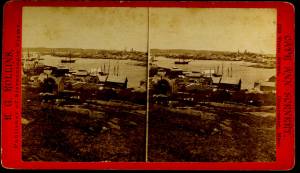
c.1870 Stereograph card Procter Brothers, Publisher Cape Ann Museum Library & Archive
"Gloucester Harbor from Rocky Neck, Looking Southwest. This gives a portion of the Harbor lying between Ten Pound Island and Eastern Point. At the time of taking this picture the wind was from the northeast, and a large fleet of fishing and other vessels were in the harbor. In the range of the picture about one hundred vessels were at anchor. In the small Cove in the foreground quite a number of dories are moored. Eastern Point appears on the left in the background."
Southeast Harbor was known for being a safe harbor.
Also filed under: Historic Photographs » // Rocky Neck » // Schooner (Fishing) » // Small Craft – Wherries, and Dories »
Collection of Erik Ronnberg
View related catalogue entries (2) »
Also filed under: Dolliver's Neck » // Fresh Water Cove » // Gloucester Harbor, Inner / Harbor Cove » // Maps »

c.1870 Stereograph card Procter Brothers, Publisher Cape Ann Museum Library & Archive
View from Civil War fort on Eastern Point.
Also filed under: Eastern Point » // Historic Photographs »

44 x 34 in.
Henry Francis Walling, Map of the Towns of Gloucester and Rockport, Essex Co. Massachusetts. Philadelphia, A. Kollner, 1851
Cape Ann Museum Library & Archive
"Map of the Towns of Gloucester and Rockport, Massachusetts. H.F. Walling, Civil Engineer. John Hanson, Publisher. 1851. Population of Gloucester in 1850: 7,805. Population of Rockport in 1850: 3,213."
Also filed under: Annisquam River » // Brookbank » // Dolliver's Neck » // Fresh Water Cove » // Maps » // Norman's Woe » // Stage Rocks / Stage Fort / Stage Head » // Steepbank » // West Gloucester – Little River » // Western Shore »
Newsprint
Cape Ann Advertiser
Cape Ann Museum Library & Archive
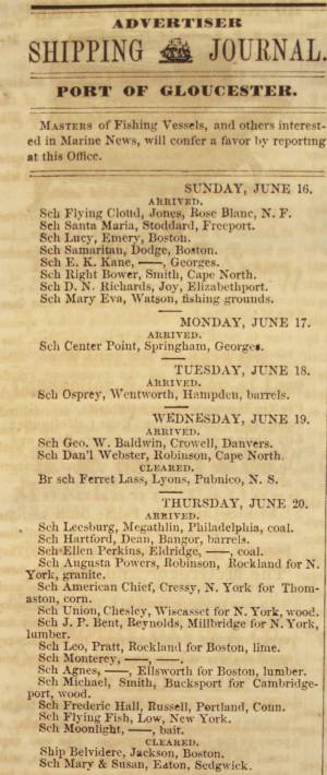
Notice in the Cape Ann Advertiser announcing arrival of ships into the port of Gloucester, with details of their cargo.
Also filed under: Newspaper / Journal Articles » // Trade Routes and Statistics »
Newspaper
"Lane's studio seldom presents so many attractions to visitors as at the present time. With unwonted rapidity his easel has turned off pictures in answer to the numerous orders which have poured in from all quarters."
Also filed under: Chronology » // Newspaper / Journal Articles » // Studio Descriptions »
Electrotype impression
Collection of Erik Ronnberg
Also filed under: Gloucester Harbor, Inner / Harbor Cove » // Maps »

c.1870 Stereograph card Procter Brothers, Publisher Cape Ann Museum Library & Archive
Also filed under: Historic Photographs » // Stage Rocks / Stage Fort / Stage Head »

Pencil and ink on paper
15 x 22 1/8 in.
Cape Ann Museum, Gloucester, Mass., Gift of Mr. Donald K. Usher, in memory of Mrs. Margaret Campbell Usher, 1984 (2401.19)
Also filed under: Beacons / Monuments / Spindles » // Mackerel Fishing »

Watercolor on paper
8 3/4 x 19 3/4 in.
Cape Ann Museum, Gloucester, Mass., Gift of Rev. and Mrs. A. A. Madsen, 1950
Accession # 1468
Fishing schooners in Gloucester's outer harbor, probably riding out bad weather.
Also filed under: Elwell, D. Jerome » // Schooner (Fishing) »
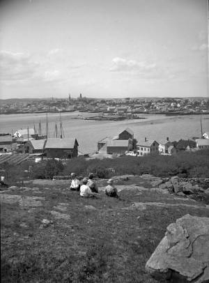
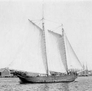
Rocky Neck lies on the eastern side of Gloucester’s Inner Harbor and along with Ten Pound Island provides a vital block to the southerly and westerly seas running down the Outer Harbor. Called Peter Mud’s Neck in the late 1600s, it was an island at high tide until the 1830s, reachable only by walking over the sand bar connecting it to the mainland at low tide. When the stone causeway was put in in the 1830s it not only made the Rocky Neck a functional neighborhood of East Gloucester, it secured the southwest end of Smith’s Cove against swell from the Outer Harbor and made the cove a tight and secure anchorage.
In Lane’s time it was primarily sheep pasture with a small population living on the fringes. In 1859 a marine railway was built at the end of the neck which is still in operation. As a result of Gloucester’s burgeoning fish trade, wharves and fish businesses quickly sprang up along the shore of the newly secure Smith’s Cove. In 1863 another landmark Gloucester business, the marine antifouling copper paint manufactory of Tarr and Wonson was built on the western tip. The Hopper-esque dark red building still stands and guards the entrance to the Inner Harbor directly across from Fort Point.
Lane drew the view for his second and third Gloucester lithographs from Rocky Neck looking across to the Inner Harbor to the town. He also did a major painting Gloucester Harbor from Rocky Neck, 1844 (inv. 14) which shows the sheep, shepherd and dog on the rocky pasture in the foreground with the busy harbor and town unfolding before them.
In the second half of the nineteenth century, Rocky Neck became an active waterfront neighborhood with a row of grand houses on its spine overlooking the harbor and town. Edward Hopper painted one of the more spectacular Beaux Arts houses on that ridge, the afternoon light catching its extraordinary trim and mansard roof, still beautifully preserved today.
Rocky Neck is perhaps best known today as Gloucester’s, and arguably America’s, most famous art colony. Beginning in the 1880’s and extending through the 1970’s, multiple generations of artists, including Homer, Duveneck, Hopper, Sloan, Twachtman and many others, representing every artistic style, have summered and worked, socialized and relaxed in the quaint and once ramshackle confines of the Neck.
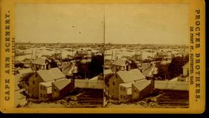
c.1870 Stereograph card Cape Ann Museum Library & Archive
Also filed under: Historic Photographs »
c.1870 Stereograph card Procter Brothers, Publisher Cape Ann Museum Library & Archive
"Gloucester Harbor from Rocky Neck, Looking Southwest. This gives a portion of the Harbor lying between Ten Pound Island and Eastern Point. At the time of taking this picture the wind was from the northeast, and a large fleet of fishing and other vessels were in the harbor. In the range of the picture about one hundred vessels were at anchor. In the small Cove in the foreground quite a number of dories are moored. Eastern Point appears on the left in the background."
Southeast Harbor was known for being a safe harbor.
Also filed under: Gloucester Harbor, Outer » // Historic Photographs » // Schooner (Fishing) » // Small Craft – Wherries, and Dories »
Newspaper clipping in "Authors and Artists "scrapbook
p.42
Cape Ann Museum Library & Archive
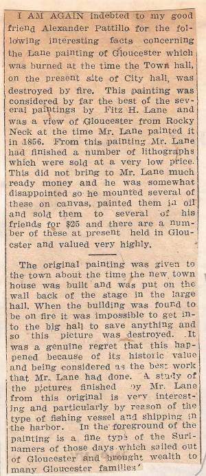
This painting was considered by far the best of the several paintings by Fitz H. Lane and was a view of Gloucester from Rocky Neck at the time Mr. Lane painted it in 1856. From this painting Mr. Lane had finished a number of lithographs which were sold at a very low price. This did not bring to Mr. Lane much ready money and he was somewhat disappointed so he mounted several of these on canvas, painted them in oil and sold them to several of his friends for $25 and there are a number of these at present held in Gloucester and valued very highly.
The original painting was given to the town about the time the new town house was built and was put on the wall back of the stage in the large hall. When the building was found to be on fire it was impossible to get into the big hall to save anything and so this picture was destroyed. It was a genuine regret that this happened because of its historic value and being considered as the best work that Mr. Lane had done. A study of the pictures finished by Mr. Lane from this original is very interesting and particularly by reason of the type of fishing vessel and shipping in the harbor. In the foreground of the painting is a fine type of the Surinamers of those days which sailed out of Gloucester and brought wealth to many Gloucester families.
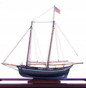
In general, brigs were small to medium size merchant vessels, generally ranging between 80 and 120 feet in hull length. Their hull forms ranged from sharp-ended (for greater speed; see Brig "Antelope" in Boston Harbor, 1863 (inv. 43)) to “kettle-bottom” (a contemporary term for full-ended with wide hull bottom for maximum cargo capacity; see Ships in Ice off Ten Pound Island, Gloucester, 1850s (inv. 44) and Boston Harbor, c.1850 (inv. 48)). The former were widely used in the packet trade (coastwise or transoceanic); the latter were bulk-carriers designed for long passages on regular routes. (1) This rig was favored by Gloucester merchants in the Surinam Trade, which led to vessels so-rigged being referred to by recent historians as Surinam brigs (see Brig "Cadet" in Gloucester Harbor, late 1840s (inv. 13) and Gloucester Harbor at Dusk, c.1852 (inv. 563)). (2)
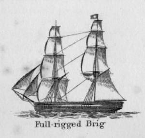
Brigs are two-masted square-rigged vessels which fall into three categories:
Full-rigged brigs—simply called brigs—were fully square-rigged on both masts. A sub-type—called a snow—had a trysail mast on the aft side of the lower main mast, on which the spanker, with its gaff and boom, was set. (3)
Brigantines were square-rigged on the fore mast, but set only square topsails on the main mast. This type was rarely seen in America in Lane’s time, but was still used for some naval vessels and European merchant vessels. The term is commonly misapplied to hermaphrodite brigs. (4)
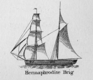
Hermaphrodite brigs—more commonly called half-brigs by American seamen and merchants—were square-rigged only on the fore mast, the main mast being rigged with a spanker and a gaff-topsail. Staysails were often set between the fore and main masts, there being no gaff-rigged sail on the fore mast.
– Erik Ronnberg
References:
1. Howard I. Chapelle, The National Watercraft Collection (Washington, DC: Smithsonian Institution, 1960), 64–68.
2. Alfred Mansfield Brooks, Gloucester Recollected: A Familiar History (Gloucester, MA: Peter Smith, 1974), 62–74. A candid and witty view of Gloucester’s Surinam Trade, which employed brigs and barks.
3. R[ichard] H[enry] Dana, Jr., The Seaman's Friend (Boston: Thomas Groom & Co., 1841. 13th ed., 1873), 100 and Plate 4 and captions; and M.H. Parry, et al., Aak to Zumbra: A Dictionary of the World's Watercraft (Newport News, VA: The Mariners’ Museum, 2000), 95.
4. Parry, 95, see Definition 1.
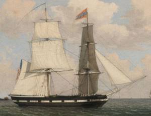
Oil on canvas
17 1/4 x 25 3/4 in.
Cape Ann Museum, Gloucester, Mass., Gift of Isabel Babson Lane, 1946 (1147.a)
Photo: Cape Ann Museum
Detail of brig "Cadet."
Also filed under: "Cadet" (Brig) »
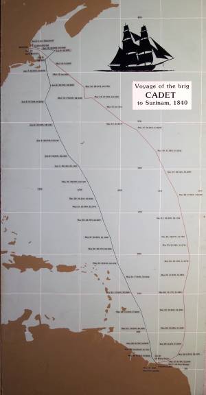
Painting on board
72 x 48 in.
Collection of Erik Ronnberg
Chart showing the voyage of the brig Cadet to Surinam and return, March 10–June 11, 1840.
Also filed under: "Cadet" (Brig) » // Surinam Trade »

Hermaphrodite brigs—more commonly called half-brigs by American seamen and merchants—were square-rigged only on the fore mast, the main mast being rigged with a spanker and a gaff-topsail. Staysails were often set between the fore and main masts, there being no gaff-rigged sail on the fore mast. (1)
The half-brig was the most common brig type used in the coasting trade and appears often in Lane’s coastal and harbor scenes. The type was further identified by the cargo it carried, if it was conspicuously limited to a specialized trade. Lumber brigs (see Shipping in Down East Waters, 1854 (inv. 212) and View of Southwest Harbor, Maine: Entrance to Somes Sound, 1852 (inv. 260)) and hay brigs (see Lighthouse at Camden, Maine, 1851 (inv. 320)) were recognizable by their conspicuous deck loads. Whaling brigs were easily distinguished by their whaleboats carried on side davits (see ). (2)
– Erik Ronnberg
References:
1. M.H. Parry, et al., Aaak to Zumbra: A Dictionary of the World's Watercraft Newport News, VA: The Mariners’ Museum, 2000), 268, 274; and A Naval Encyclopaedia (L.R. Hamersly & Co., 1884. Reprint: Detroit, MI: Gale Research Company, 1971), 93, under "Brig-schooner."
2. W.H. Bunting, An Eye for the Coast (Gardiner, ME: Tilbury House: 1998), 52–54, 68–69; and W.H. Bunting, A Day's Work, part 1 (Gardiner, ME: Tilbury House: 1997), 52.
The colonial American shallop is the ancestor of many regional types of New England fishing craft found in Lane's paintings and drawings, including "New England Boats" (known as "boats" and discussed elsewhere), and later descendents, such as "Chebacco Boats," "Dogbodies," and "Pinkies."
These boats were very common work boat types on Cape Ann throughout the 1800s. They were primarily used for inshore coastal fishing, which included lobstering, gill-netting, fish-trapping, hand-lining, and the like. They were usually sailed by one or two men, sometimes with a boy, and could be rowed as well as sailed. An ordinary catch would include rock cod, flounder, fluke, dabs, or other small flat fish. The catch would be eaten fresh, or salted and stored for later consumption, or used as bait fish. Gill-netting would catch herring and alewives when spawning. Wooden lobster traps were marked with buoys much as they are today, and hauled over the low sides of the boat, emptied of lobsters and any by-catch, re-baited and thrown back.
CHEBACCO BOATS AND PINKIES
In the Chebacco Parish of the Ipswich Colony, a larger version of the colonial shallop evolved to a heavily built two-masted boat with either a sharp or square stern. This development included partial decking at bow and stern, the former as a cuddy which was fitted with crude bunks and a brick fireplace for cooking. Further development provided midship decking over a fish hold with standing rooms fore and aft for fishing. At this stage, low bulwarks replaced simple rails and in the double-enders were extended aft beyond the rudderhead to form a “pinched,” or “pink“ stern. Some time in the second half of the eighteenth century, boats with these characteristics became known as Chebacco Boats. The squarestern versions were called Dogbodies, for reasons now forgotten. (1)
Chebacco Boats became the vessels of choice for Cape Ann fishermen working coastal grounds for cod, mackerel, herring, and groundfish with hook and line or with nets. This did not prevent them from venturing further, particularly in pursuit of migrating schools of mackerel. The “Bashalore,” a corruption of the Bay of Chaleur in the Gulf of St. Lawrence, was a favorite destination for Cape Ann Fishermen who fished for mackerel in that region. (2)
Lane undoubtedly saw Chebacco Boats in the years prior to his move to Boston, but if he made drawings or paintings of them in that period, none have come to light. A small lithograph, titled “View of the Old Fort and Harbor 1837,” is attributed to him, but the vessels and wharf buildings are too crudely drawn to warrant this undocumented claim. (3) Lane did see and render accurately the Chebacco Boat’s successor the Pinky—which was larger and had a schooner rig (two masts, main sail, fore sail, jib, and main topmast staysail).
Schooners with pinksterns were recorded early in the 18th century later that there were models and graphic representations of hull form and rig (Ref. 4). By then, the pinky was very similar in hull form to Chebacco Boats, and some Chebacco Boats were converted to pinkies by giving them schooner rigs. A pinky in Lane’s The Old Fort and Ten Pound Island, Gloucester, 1850s (inv. 30) (misdated 1850s, more likely mid-1840s) is quite possibly an example of such a conversion.
Lane’s depictions of pinkies in Massachusetts waters are numerous and sometimes very informative. Examples in his views of Gloucester Harbor portray them at various angles, from broadside (see Gloucester Harbor from Rocky Neck, 1844 (inv. 14), The Old Fort and Ten Pound Island, Gloucester, 1850s (inv. 30), and View of the Town of Gloucester, Mass., 1836 (inv. 86)) to stern (see The Western Shore with Norman's Woe, 1862 (inv. 18), The Old Fort and Ten Pound Island, Gloucester, 1850s (inv. 30), and Gloucester Harbor, 1850s (inv. 391)), but few, if any, bow views. His portrayals of pinkies in Boston Harbor and vicinity are more in the foreground and more generous in detail. The earliest of these, from 1845, shows a pinky getting underway in a hurry as the yacht "Northern Light" bears down on her in The Yacht "Northern Light" in Boston Harbor, 1845 (inv. 268). A late harbor view (id ) offers a rare bow view.
Like the Chebacco Boat, the pinky was primarily a fishing vessel, doing much the same kind of fishing in coastal waters, but large enough to venture further offshore to work on the banks in the Gulf of Maine in pursuit of the cod. By the 1820s, pinkies reached their largest size: 50 to 60 feet on deck. Beyond that size called for a different deck arrangement and higher rails, so men could stand on deck and fish from the rails – an arrangement offered by the banks fishing schooner. (5)
What is perhaps Lane’s most detailed and narrative view of a pinky appears in Becalmed Off Halfway Rock, 1860 (inv. 344) and dominates the right foreground. Fitted-out for mackerel gillnetting, she has a dory and a wherry in tow, the latter with the net in the stern. The crew is relaxed, enjoying the evening calm as the vessel heads for port. The barrels on deck are filled with freshly caught mackerel, which will be sold as such when landed, most likely at Gloucester. This pinky was probably fishing on Stellwagen Bank or Cape Cod Bay, which were good fishing grounds for mackerel, and close enough to Gloucester to make trips in smaller vessels worthwhile. To judge from his paintings, Lane found only a few pinkies in the parts of the Maine Coast he explored. Only one drawing (Southwest Harbor, Mount Desert, 1852 (inv. 184)) and two widely published paintings (Entrance of Somes Sound, Mount Desert, Maine, 1855 (inv. 347) and Bar Island and Mt. Desert Mountains from Somes Settlement, 1850 (inv. 401)) illustrate this type, and then at a distance. What is apparent is that pinkies in southern Maine did not differ markedly from those on the Massachusetts coast. Had Lane ventured further Down East, he might have found modifications to the type that reflected Canadian influences. (6)
– Erik Ronnberg
References:
1. William A. Baker, Sloops & Shallops (Barre, MA: Barre Publishing Co., 1966), 82–91; and Howard I. Chapelle, The American Fishing Schooners, 1825–1935 (New York: W.W. Norton & Co., 1973), 25–27.
2. G. Brown Goode, The Fisheries and Fishery Industries of the United States, Section V, Vol. I (Washington, DC: Government Printing Office, 1884–87), 275, 287, 298–300, 419–21, 425–32, 459–63.
3. John J. Babson, History of the Town of Gloucester, Cape Ann (Procter Bros., 1860, reprint: Gloucester, MA: Peter Smith, 1972), see lithograph facing p. 474.
4. Goode, 275–77, 280, 294–96.
5. Chapelle, 36–37.
6. Ibid., 45–54.
Glass plate negative
3 x 4 in.
Cape Ann Museum Library & Archive
#10112
Also filed under: Gloucester Harbor, Inner / Harbor Cove »
Also filed under: Ship Models »
Also filed under: Ship Models »
Also filed under: Ship Models » // Small Craft – Wherries, and Dories »
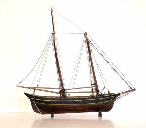
20" l. x 19" h. x 3 3/4" w. [not to scale]
Cape Ann Museum. Gift of Mr. J. Hollis Griffin, 1940 (891)
"Pinkys" were early nineteenth-century schooner-rigged derivations of Chebacco boats. This model is a good example of a traditional “sailor’s model,” or in this case, a sailmaker’s model, Mr. Nickerson having been a sailmaker.
Also filed under: Ship Models »
1860 In John J. Babson, History of the Town Gloucester (Gloucester, MA: Procter Brothers, 1860) Cape Ann Museum Library & Archives, Gloucester, Mass.
See p. 474.
View related catalogue entries (4) »
Also filed under: Babson History of the Town of Gloucester » // Fort (The) and Fort Point » // Gloucester Harbor, Inner / Harbor Cove » // Gloucester, Mass. - "Ten Pound Island Light » // Schooner (Coasting / Lumber / Topsail / Packet / Marsh Hay) » // Ten Pound Island »
"Party boat" is a colloquial term for any kind of small craft adapted or used for taking guests (customarily for hire) on sightseeing trips or fishing for pleasure. (1) The term survives to this day on Cape Ann and other places for vessels engaged in the same activities. (2) In Lane's time, party boating was a calling of opportunity, and a fisherman's boat might be used in season - regularly or occasionally - to take "rusticators" fishing. Likewise, a boat used for its owner's own pleasure might be hired to take sightseers sailing for an afternoon. The latter use is seen in Lane's 1844 view of Gloucester Harbor from Rocky Neck (see the yawl-rigged sailboat in the foreground of Gloucester Harbor from Rocky Neck, 1844 (inv. 14)).
By the early 1850s, summer visitor activity, encouraged by the building of the Pavilion Hotel on Gloucester's waterfront, led to increased pleasure boating activity, if Lane's painting Gloucester Harbor, 1852 (inv. 38) of Pavilion Beach and Sidney Mason's hotel is any indication. (3) Lane's Gloucester Harbor scenes from this decade show a number of pleasure craft suitable for taking passengers for hire (see Fresh Water Cove from Dolliver's Neck, Gloucester, Early 1850s (inv. 45), Coming Ashore near Brace's Rock, Gloucester, Massachusetts, c.1860 (inv. 60), and View of Gloucester from "Brookbank," the Sawyer Homestead, c.1856 (inv. 95)). Small working craft suitable for this purpose are seen in The Old Fort and Ten Pound Island, Gloucester, 1850s (inv. 30), Gloucester Harbor, 1852 (inv. 38) (right foreground), View of Gloucester, 1859 (inv. 91) (foreground), and Watch House Point, 1860 (inv. 292) (right foreground). In View of Gloucester Harbor, 1848 (inv. 97), we see passengers boarding a small sloop-rigged boat hidden by the rocks at Duncan's Point (left middle ground).
In coastal waters south of Gloucester, a few of Lane's paintings offer pleasure craft as candidates for taking paying passengers. Phantom of Boston, c.1850s (inv. 574) depicts a cruising yawl "Phantom" of Boston, beached with hunting gear unloaded alongside while two of the crew await an approaching party in a rowing boat. The location is unidentified, but a possibility is the barrier beach around the marshes of Lynn, Massachusetts, which were once very popular hunting grounds for migrating waterfowl. A second candidate is a small sloop with a party of four on an evening sail off Halfway Rock in Becalmed Off Halfway Rock, 1860 (inv. 344) (far right).
Lane found similar uses of working watercraft in Maine, where the families of a small coastal community would travel by their workboats to a gathering place for a clambake or similar festive outing (see View of Indian Bar Cove, Brooksville, Maine, 1850 (inv. 61)). The artist became a "rusticator" himself when he, Joseph Stevens, and friends explored Mount Desert Island and vicinity in the "General Gates," a sloop-rigged Maine version of a New England Boat (View of Bar Island and Mount Desert Mountains, from the Bay in Front of Somes Settlement, 1850 (inv. 177) and Castine Harbor and Town, 1851 (inv. 272)).
When Lane traveled to New Bedford in 1856 to observe and sketch a regatta held by the New York Yacht Club, he observed and sketched it while on board an unknown vessel near the starting and finishing line, formed by the race committee boat "Emblem" and her yawl-boat.
Close by was a small party boat with observers on board, probably a fishing sloop, given its work-a-day looks. In the ensuing year, Lane painted four detailed views of this race, the party boat appearing in New York Yacht Club Regatta (1), 1856 (inv. 66) (right foreground); New York Yacht Club Regatta (2), 1856 (inv. 270) (right margin); New York Yacht Club Regatta (3), After 1856 (inv. 396) (center); and New York Yacht Club Regatta (4), 1857 (inv. 397) (left foreground). (4)
– Erik Ronnberg
References:
1. M. H. Parry and others, Aak to Zumbra: A Dictionary of the World's Watercraft (Newport News, VA: The Mariners' Museum, 2000), 436.
2. Ibid.
3. Proctor's Able Sheet (a Gloucester newspaper), January 1857: "Gloucester House reopened—refitted—boats always ready to take parties cruising or fishing..."
4. John Wilmerding, Fitz Henry Lane, 2nd ed. (Cape Ann, MA: Cape Ann Historical Association, 2005), 52–54. Lane's 1852 cruise in the Mount Desert region in the sloop "Superior" was reprinted as an appendix to Wilmerding's essay in Paintings by Fitz Hugh Lane (Washington, DC: National Gallery of Art, 1988), 125–26.
Oil on canvas
34 x 45 3/4 in.
Cape Ann Museum, Gloucester, Mass., Gift of Mrs. Jane Parker Stacy (Mrs. George O. Stacy),1948 (1289.1a)
Detail of party boat.
Also filed under: Gloucester Harbor, Inner / Harbor Cove »

Oil on canvas
22 x 36 in.
Cape Ann Museum, Gloucester, Mass., deposited by the Collection of Addison Gilbert Hospital, 1978 (DEP. 201)
Detail of party boat.
Also filed under: Ten Pound Island »
Newspaper
Ad in Gloucester Telegraph
FISHING AND SAILING PARTIES
"Persons desirous of enjoying a SAILING or FISHING EXCURSION, are informed that the subscriber will be in readiness with the Boat EUREKA, to attend to all who may favor him with their patronage. JOHN J. FERSON"
Also filed under: Gloucester Harbor – Use » // Newspaper / Journal Articles »
Newsprint
Ad for Gloucester House
Courtesy of the American Antiquarian Society, Worcester, Mass.
See p. 4, column 2.
Also filed under: Brick Houses / Gloucester House Hotel » // Newspaper / Journal Articles »
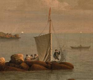
Sloops are one-masted sailing vessels which, in American examples, set fore-and-aft sails but usually no square sails. Thus, staysails, or jibs, are set from the fore stay(s) and a quadrilateral mainsail is set from the mast and spread by a gaff and a boom. The larger sloops would often set a triangular topsail over the main sail. (1)
The sloops depicted by Lane were used in various coastal trades, each with its own requirements, which dictated the sizes and details of their hulls and rigs. Most elegant were the packet sloops, which transported passengers, mail, and higher value goods between specific ports on regular schedules. They usually measured between sixty and seventy-five feet on deck, as dictated by anticipated shipping volume. Finely finished, they usually had stern galleries—a row of windows across the transom with ornamental moldings—and varied color schemes. Examples of packet sloops are in Gloucester Harbor from Rocky Neck, 1844 (inv. 14) (center, middle ground) and Study of Ships, 1851 (inv. 141) (foreground), both of which probably made trips between Gloucester and Boston, or Gloucester and Newburyport. (2)
Another specialized sloop of similar size was the stone sloop, used to ship granite blocks from stone-loading piers around Cape Ann to other ports. They were similar in rig to packet sloops, but of heavier construction with greater hold capacity and absence of decoration. Their stout appearance was augmented by simple color schemes, or even tarred topsides, reflecting the wear and strain imposed by their heavy cargos. Lane depicted these vessels in his painting of Fresh Water Cove from Dolliver's Neck, Gloucester, Early 1850s (inv. 45), with a sloop (at left) preparing to load at wharf-side, and another (at right) sailing out with a cargo. (3)
Sloops of the more work-a-day sort are the most commonly seen examples in Lane’s paintings, most of them appearing in his views of Boston Harbor. Usually deep-loaded and looking weather-worn, they contrast sharply with the packet- and clipper ships which dominate the scene. Sloops of this type are rarely seen in Lane’s paintings of Gloucester Harbor and the Maine coast, although they were certainly needed for short-distance transportation (see Bear Island, Northeast Harbor, 1855 (inv. 24), View of Camden Mountains from Penobscot Bay, c.1852 (inv. 207), Sunrise on the Maine Coast, Mount Desert Island, 1856 (inv. 295)). For coastal Maine, lack of railroads for heavier freight and greater distances between ports made the use of schooners with larger carrying capacity a greater necessity. (4)
In Lane’s views of New York Harbor, a regional sloop variant, the Hudson River Sloop, appears in New York Harbor, c.1855 (inv. 46) (bow view, left) and A Calm Sea, c.1860 (inv. 6) (stern view, right). This type had become prominent in the Hudson River packet trade between New York City, Albany, and beyond to points north and west as far as the eastern terminus of the Erie Canal. Large vessels for their rigs, they were well-finished and well-kept, reflecting pride of ownership and rivalry among their owners and crews. (5)
– Erik Ronnberg
References:
1. A Naval Encyclopaedia (Philadelphia: L.R. Hamersly & Co., 1884. Reprint: Detroit, MI: Gale Research Company, 1971), 59. See first definition of "sloop" and definition of "sloop-rigged."
2. Robert Greenhalgh Albion, William A. Baker, and Benjamin Woods Labaree, New England and the Sea (Mystic, CT: Mystic Seaport Museum, 1972; reprinted in 1994), 127–28.
3. Howard I. Chapelle, The History of American Sailing Ships (New York: W.W. Norton & Co., 1935), 300–02.
4. Ibid., 300.
5. Ibid., 298–300.
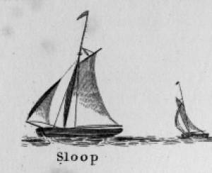
A Naval Encyclopaedia:
Dictionary of nautical words and phrases
Special Articles on Naval Art and Science
Philadelphia: L.R. Hamersly & Co.
'Mudian, "Mugian, or Bermudian. A boat special to the Bermuda islands, usually decked, with the exception of a hatch; from 2 to 20 tons burden; it is short, of good beam, and great draft of water abaft, the stem and keel forming a curved line. It carries an immense quantity of ballast. Besides a long main- and short jib-boom, it has a long, taperking, raking mast, stepped just over the forefoot, generally unsupported by shrouds or stays; on it a jib-headed mainsail is hoisted to a height of twice, and sometimes three times, the length of the keel. This sail is triangular, stretched at its foot by a long boom. The only other sail is a small foresail or jib. They claim to be the fastest craft in the world for working to windward in smooth water, it being recorded of one that she made five miles dead to windward in the hour during a race; and though they may be laid over until they fill with water, they will not capsize.
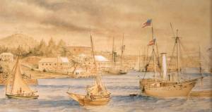
St. George's Historical Society
Detail of painting of St. George's Harbour, Bermuda, during US Civil War, with a Confederate blockade runner anchored in the foreground.
Also filed under: Puerto Rico »
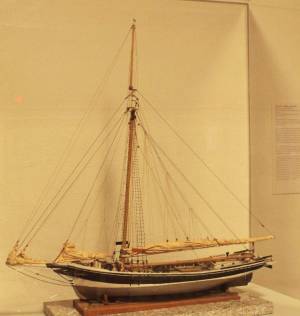
Wood, metal, cordage, cloth, paint.
Scale: ¼ in. = 1ft. (1:48)
Cape Ann Museum. Gift of Roland and Martta Blanchet (1997.17.3)
Although built in 1890 and larger than the stone sloops of Lane’s time, the "Albert Baldwin’s" hull form, rig, and loading boom are very similar to those of the 1840s and 1850s.
Also filed under: Granite Quarrying / Shipping » // Ship Models »
Bird hunting was an activity undertaken for both pleasure and by fishermen to protect the drying fish flakes and their nets. During the nesting seasons, the breeding grounds were systematically raided and the absence of seagulls in Lane's harbor scenes can be attributed to the fact that the population of sea birds was controlled. In addition, watchmen with fowling pieces protected the fish flakes.
Personal journal
Wilson Museum, Castine, Maine
Box 2, F1 (A00772)
John Stevens was the younger brother of Joseph Stevens, and acquainted with Lane, spending time with him in Gloucester and at the family home in Castine. His journal, quoted below, includes reference to hunting plover and teal, school, sailing, local events. Mentions Castine mill, lighthouse, and block house.
"Friday [September] 17th: Cloudy all day. Wind N. blowing quite hard. A British Rig loaded with salt from Liverpool came into port last night. She run way up by the Monument and got aground. They kedged her off this P.M. and came down. She came in with one of these old English charts as her guide. They have the town set down on the Brooksville side, two miles + three quarters from the lighthouse."
"Wednesday [September] 22. . .Went down to the Indians Camp on the Back Cove. There were five camps of them."
Visits Gloucester from Castine:
"Wednesday [October] 27th. . .Left for Gloucester [from Boston] at 5 o'clock this P.M. arrived there safe + sound at 6 1/2 o'clock; went right down to the store and saw Joe. We then went up to his house and got supper.
"Thursday [October] 28th. At. Gloucester. Pleasant day. Went down to the "Cut" a gunning this morning before breakfast but saw no birds. Went out in the harbor this forenoon alone, had a fine sail but couldn't get a chance at any birds. Went out again this P.M. got down to East Point Light and the wind died all away, so I had to scull home."
"Friday 29th. Very pleasant day, went out in the harbor this morning with Joe. Took a walk this A.M. with "Lina", called on Mr. Lane + Doct. Hildreth. Joe + I went out in the harbor this P.M. I fired at some birds several times, but didn't get any. . . ."
Also filed under: Biographical information » // Castine » // Castine – School » // Chronology » // Cut, The (Stacy Blvd.) » // Diaries / Ledgers / Etc. » // Stevens, Joseph, Jr. »
Charles Fox Hovey was a Boston dry-goods merchant, who for nine years had a house in Gloucester. In 1845, the Town of Gloucester sold Mr. Hovey a plot of land on Granite Street on which he built a house. He sold the house and land to Capt. Edward Babson in 1854. (1)
Hovey (1807–59) was born in Brookfield, MA, one of the four sons of Darius and Sarah (Howe) Hovey. He married Justine de Peyster (1820–91) in New York in 1837. They had six children, two of whom died young. (2)
In 1841, he and two associates began Hovey, Williams and Co., an import and wholesale dry goods business with offices on Water Street in Boston. By 1848, they had merged with a retail store and were on Summer Street, Boston as C. F. Hovey & Co. They also opened offices in New York and Paris and became innovators in department-store merchandising, introducing a simple pricing system as well as instigating early closing hours, employee profit-sharing and a customer credit system with monthly billing. They were taken over by Jordan Marsh in 1947. (2)
Mr. Hovey was an ardent abolitionist who, along with other Boston businessmen, provided most of the funding for the American Anti-Slavery Society. He also strongly supported Woman Suffrage, free trade and temperance. In his will he instructed that all his residual estate, after payment of all other legacies and bequests, was to be set up in a trust that would pay out no less than eight thousand dollars a year (until the principal was exhausted) to support abolitionist efforts. This became the Hovey Fund, headed by Wendell Phillips. (4)
His funeral held on May 2, 1859 was attended by many people, among them William Lloyd Garrison (who spoke), Wendell Phillips and Rev. Thomas Starr King. (5)
– Stephanie Buck
(1) Cape Ann Museum BR Box P 33 FF4 & Salem Registry of Deeds Bk. 502: 210.
(2) Harvard Business School records - Mss:776, H846.
(3) Vital Records, New England Historical and Genealogical Society.
(4) The Letters of William Lloyd Garrison: From Disunionism to the Brink of War, 1850–1860 (Cambridge, MA: Harvard University Press, 1976).
(5) "Tribute to the memory of Charles F. Hovey, esq.," The Liberator, May 6, 1859.
Lithographs were sold in two ways: either they were published by a dealer or shop who paid for the cost of the printmaking, or an artist would sell a print by subscription. In the case of subscription, the artist would place a notice in a newspaper about the intent to make the print, put the original drawing on display, and subscribers would pledge payment. In this way the artist could gauge interest before employing the lithography shop to print the composition. This is the way in which Lane printed both View of Gloucester, 1859 (inv. 446) and Castine, from Hospital Island, 1855 (inv. 448).
Much of this information is drawn from Boston Lithography, 1825–1880 by Sally Pierce and Catharina Slautterback.
See p. 2, column 6.
Also filed under: Procter Brothers »
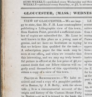
Newspaper
Gloucester Telegraph: View of Gloucester, p. 2, col. 1
American Antiquarian Society
"VIEW OF GLOUCESTER. – We are happy to state, that Mr. F. H. Lane contemplates publishing a Lithographic view of this town, from Eastern Point, provided a sufficient number of copies are subscribed for. Mr. Lane is well known in this place as a young man of genius, and we have no hesitation in saying that we believe him qualified for the task. – A subscription paper for this work may be seen at our office, and when we consider that this interesting, and we may say truly beautiful picture is offered at the low price of $1, we cannot doubt that our fellow citizens will eagerly avail themselves of this opportunity to obtain a copy of a view of this town."
Also filed under: Chronology » // Newspaper / Journal Articles »
12.19.1835 Newspaper Gloucester Telegraph: Items, p. 1, col. 5 American Antiquarian Society
“We are requested to inform the public that Mr. LANE’s View of Gloucester is in a state of forwardness, and will be completed by the first or middle of February next. Persons wishing to obtain a good lithographic view of Gloucester, and disposed to encourage a native artist, can subscribe by applying to ISAAC A. SMITH, No. 33, Front Street.”
Also filed under: Isaac A. P. Smith store » // Newspaper / Journal Articles »
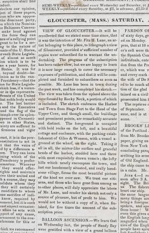
Newspaper
Gloucester Telegraph: View of Gloucester, p. 1, col. 1
American Antiquarian Society
“VIEW OF GLOUCESTER. – It will be recollected that we stated some time since, that it was the intention of Mr. Fitz H. Lane, an artist belonging to this place, to lithograph a view of Gloucester, provided a sufficient number of copies were subscribed for to warrant the undertaking. The progress of the subscription has been rather slow, but we are happy to learn it is now large enough to cover the necessary expenses of publication, and that it will be completed and furnished to subscribers as soon as possible. Mr. Lane has been in town during the past week, and has completed his sketch. – The view was taken from the upland above the cove formed by Rocky Neck, a portion of which is included. The sketch embraces the Harbor and Town from Stage Fort to the Head of the Upper Cove, and though small, the buildings and prominent points, are remarkably accurate and distinct. The foreground is occupied with bold rocks on the left, and a beautiful cottage and enclosure, with the packing establishment of Giles & Wonson, with a vessel aground at the wharf, on the right. Taking it all in all, the mirror-like surface and graceful bends of the harbor, studded here and there with most exquisitely drawn vessels; the lofty hills which nearly encompass the town, and last our handsomely situated, and really handsome village, forms the most beautiful picture of the kind we ever saw. We trust our citizens, and those who have gone from among us to other places, will duly appreciate the labors of Mr. Lane, and render his sketch not only a source of pleasure, but of profit to him. We would not be without a copy of it, when finished, for five times the amount of the subscription price.”
Also filed under: Newspaper / Journal Articles »
3.16.1836 Newspaper Gloucester Telegraph: p. 2, col. 3 American Antiquarian Society
“We have received a copy of a lithographic sketch of the town of Gloucester, executed by Mr. FITZ H. LANE of this town. The sketch itself is, we think, most admirably executed; and so far as we are acquainted with the art, there is a softness and beauty in the design, which we do not always find in the works of older and more distinguished artists. We think that the effect would have been more striking, had the view been taken from some other place than Eastern Point. There are several places whence the town could be seen to better advantage. However, we do not mean to find fault with so deserving a performance; and we hope the people of Gloucester will encourage an artist whose youth and evident talent, with other circumstances, (that of his being a native, not the least,) ought to entitle him to their liberal patronage. We venture to predict that he will one day become distinguished in his art.
Subscribers and others may obtain the print at the store of Isaac A. Smith.”
Also filed under: Chronology » // Isaac A. P. Smith store » // Newspaper / Journal Articles »
Newspaper
p. 3
"Engravings. A splendid lot of Engravings, at 12 1/2 cents each, just rec'd at 68 Front Street, among which are the following: The May Queen, Augusta, Clara, Victoria, Nancy, The Sleeping Beauty, John Tyler, Landing of the Pilgrims, Flower Vase, Brig Somers, Father Matthew, Mourning Pieces, suitable for framing - also Portraits of the People."
Unknown Newspaper
"Our fellow townsman, Mr. Fitz H. Lane, has just published a splendid Lithographic view of Gloucester, which we think is far superior to his former one. It is one of the most perfect pictures of the kind we have ever seen, every house and object being distinctly visible. Copies of it can be obtained at Mr. Charles Smith's Bookstore, at the reasonable price of $1."
Also filed under: Newspaper / Journal Articles »
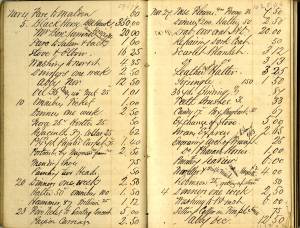
Samuel Sawyer Papers
Cape Ann Museum Library & Archives
Archive Collection exp013
"November 27. Engraving. Arch of Triumph (To James 1/53)
Engraving. Pharaoh’s Horses Painting. Seaview
Traveller & milkmaid. Companions. Hogarth. $2."
Also filed under: Diaries / Ledgers / Etc. » // Sawyer, Samuel »
See p. 3, column 3.
“ELWELL’S SKY LIGHT DAGUERREOTYPE ROOMS, No. 77 1–2 Front Street (Over Shaw’s Clothing Store,) Gloucester. Every description of plain and fancy case to be found in the market. Also Gold, Plated and Gilt Lockets constantly on hand. As to the quality of the pictures, call and examine.”
Also filed under: Newspaper / Journal Articles »
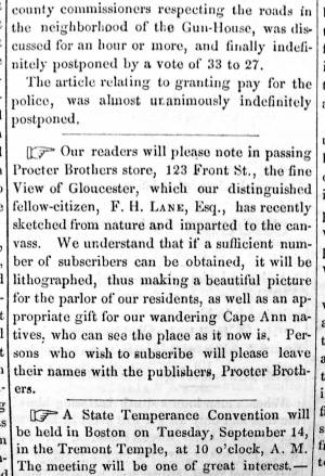
Newsprint
From bound volume owned by publisher Francis Procter
Collection of Fred and Stephanie Buck
"Our readers will please note in passing Procter Brothers store, 123 Front St., the fine View of Gloucester, which our distinguished fellow-citizen, F.H. LANE, Esq., has recently sketched from nature and imparted to the canvass. We understand that if a sufficient number of subscribers can be obtained, it will be lithographed, thus making a beautiful picture for the parlor of our residents, as well as an appropriate gift for our wandering Cape Ann natives, who can see the place as it now is. Persons who wish to subscribe will please leave their names with the publishers, Procter Brothers."
Newspaper
"Please note the fine view of Gloucester recently sketched by F.H. Lane, Esq. A sufficient number of subscribers will allow it to be lithographed-leave your name with Procter Bros.
Also filed under: Newspaper / Journal Articles » // Procter Brothers – Gloucester, Mass. »
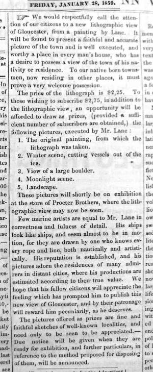
Newsprint
From bound volume owned by publisher Francis Procter
Collection of Fred and Stephanie Buck
"We would respectfully call the attention of our citizens to a new lithographic view of Gloucester, from a painting by Lane. It will be found to present a faithful and accurate picture of the town and is well executed, and worthy a place in every man's house, who has a desire to possess a view of the town of his nativity or residence. To our native born townsmen, now residing in other places, it must prove a very welcome possession. The price of the lithograph is $2.25. To those wishing to subscribe $2.75, in addition to the lithographic view, an opportunity will be afforded to draw as prizes, (provided a sufficient number of subscribers are obtained,) the following pictures, executed by Mr. Lane:
1. The original painting, from which the lithograph was taken.
2. Winter scene, cutting vessels out of the ice.
3. View of a large boulder.
4. Moonlight scene.
5. Landscape.
These pictures will shortly be on exhibition at the store of Procter Brothers, where the lithographic view may now be seen.
Few marine artists are equal to Mr. Lane in correctness and fulness of detail. His ships look like ships, and seem almost to be in motion, for they are drawn by one who knows every rope and line, both nautically and artistically. His reputation and established, and his pictures adorn the residences of many admirers in distant cities, where his productions are estimated according to there true value. We hope that his fellow citizens will appreciate the feeling which has prompted him to publish this new view of Gloucester, and by their patronage will reward him pecuniarily, as he deserves.
The pictures offered as prizes are fine and faithful sketches of well-known localities, and need only to be seen to be appreciated. – Due notice will be given when they are ready for exhibition, and further particulars, in reference to the method proposed for disposing of them, will be announced."
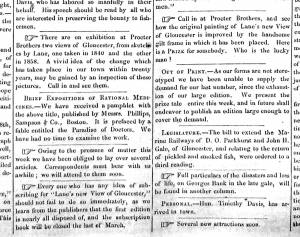
From bound volume owned by publisher Francis Procter
Collection of Fred and Stephanie Buck
This clipping has three separate sections on Lane:
"There are on exhibition at Procter Brothers two views of Gloucester, from sketches by Lane, one taken in 1840 and the other in 1858. A vivid idea of the change which has taken place in our town within twenty years, may be gained by an inspection of these pictures. Call in and see them. . . .
Every one who has any idea of subscribing for 'Lane's new View of Gloucester,' should not fail to do so immediately, as we learn from the publishers that the first edition is nearly all disposed of, and the subscription book will be closed the last of March. . . .
Call in at Procter Brothers, and see how they original painting of Lane's new View of Gloucester is improved by the handsome gilt frame in which it has been placed. Here is a PRIZE for somebody. Who is the lucky man?"
Also filed under: Newspaper / Journal Articles » // Procter Brothers » // Procter Brothers – Gloucester, Mass. »
Newspaper
Gloucester Telegraph p. 2, col. 3
Boston Public Library
Accession # G587
"PICTURES. – Two of Lane's finest paintings are on exhibition at the Marine Insurance Reading Room. One is a most spirited representation of a gale on the sea coast. Huge rollers come rumbling towards the rocky foreground where the spray dashes high and the receding wave is thrown up sharp and wedgelike by the great crested breaker under which it is speedily overwhelmed. In the middle distance a bald headland receives the sun's rays which slant through the mist from an opening in the heavy clouds. A close reefed ship leaps proudly over the waves and safely weathers the dangerous point beyond.
The companion-piece is a bay scene in which the setting sun throws a flood of golden light over the placid water. Vessels of different kinds, with sails in light and shadow, enliven the picture. A homely old sloop getting underweigh well sets off the most prominent object - a handsome ship under full canvass, slowly gliding over the ground-swell with a light breeze afloat, while there is hardly enough below to make a cat's paw.
These pictures were painted for the spring exhibition of the National Academy at New York, whither they will go unless stopped by some appreciative purchaser.
In Lane's studio are several gems of art. - Wind against Tide on Georges, a stirring pure marine, and Recollections of Mount Desert, an exquisite bit of landscape, evince a versatility of pencil which he is not generally known to possess.
The demand for a View of Gloucester worth having (as that poor caricature of Tidd's is not) has induced Lane to supply another, which is the third and largest of his series. It is taken from Rocky Neck, like its predecessor. Of course all the modern improvements visible from that point of view are represented with the artist's usual accuracy of drawing. To the first 300 subscribers the print will be offered at the low price of $2.25 per copy. The original painting from which it is lithographed, and several other of his pictures, will be distributed by lot among those who choose to take their copies at $2.75 – a price which the print alone will command before the entire edition is exhausted."
Newspaper
"We learn from the publishers that the 300 copies of "Lane's new view of Gloucester," comprising the first edition, and with which each subscriber is entitled to a share in the original, and four other of Mr. Lane's beautiful paintings, all in splendid frames, are nearly taken up, and the paintings will probably be distributed on Monday, July 4th. Those who wish one of these beautiful views, should not neglect this opportunity, and subscribers who have not got their subscription cards, will please secure them without delay."
Newspaper
"Subscribers to "Lane's new View of Gloucester," are particularly requested to secure their tickets in said View without delay. There is a few still left, which of those who have neglected to purchase will at once secure- The publishers are anxious to close it up and deliver the paintings to the lucky subscribers during the present month. Shall they do so?"
9.21.1859 Newspaper Gloucester Telegraph, p. 2, col. 3 Boston Public Library Accession # G587
"DRAWING OF PAINTINGS.– The distribution of five oil paintings among the subscribers to Lane’s view of Gloucester, took place on Saturday Evening, at the store of Messrs. Procter Brothers. No. 125 took the first picture, being the original painting from which the view of Gloucester was engraved. It is a valuable picture, and Mr. John H. Whidden was the lucky holder of the number. The second picture, a winter scene, giving a representation of cutting vessels out of the ice, fell to No. 186, the holder of which was Mr. William Parsons, 2d. The third picture, a moonlight scene, was taken by No. 263, which was held by Mr. Joseph Richardson of Boston. The fourth, a landscape view, fell to No. 2, the owner of which was Mr. Solomon Pool. No. 93 took the fifth, a view of a large boulder, and Mr. William D. Winchester held the ticket."
9.23.1859 Newspaper
Distribution of Oil Paintings to Subscribers of "Lane's View of Gloucester."
#125- 1st Prize of the original painting to J.H. Whidden
#186- 2nd Prize, Winter Scene, cutting vessels out of the ice. Wm. Parsons, 2nd
#263- 3rd Prize, Moonlight Scene, Joseph Richardson
#2- 4th Prize, a beautiful landscape view, Solomon Pool
#93- 5th Prize, view of a Large Bowlder. Wm. D. Winchester
Newspaper
"Lane's new view of Gloucester- An advanced impression of this splendid lithograph has been received by the publishers, Procter Brothers,... We learn that the canvas for this work will be commenced soon... We understand that under suggestions from the artist, Mr. Lane, several improvements will be made on this copy, making the regular issue of prints more desirable that the sample."
Newspaper
"All who have subscribed to Mr. Lane's painting should do so as the list is filling up fast. First signers get best impression of the print 27" x 40" The prizes are 5 oil paintings in gilt frame."
Also filed under: Newspaper / Journal Articles » // Procter Brothers – Gloucester, Mass. »
Newspaper
Gloucester Telegraph
The second great Front St. fire burned as close as Low's stable next to Lane's house. Lane lost 200 copies of Gloucester Lithography at Procter Bros.
Also filed under: Newspaper / Journal Articles » // Procter Brothers – Gloucester, Mass. »
Handwritten list
Wilson Museum, Castine, Maine (A00787-1a-1d)
Also filed under: Castine » // Castine – Witherle & Co.'s Store » // Noyes, Samuel » // Publications » // Stevens, Joseph, Jr. » // Witherle, William Howe »
Newspaper clipping in "Authors and Artists "scrapbook
p.42
Cape Ann Museum Library & Archive
This painting was considered by far the best of the several paintings by Fitz H. Lane and was a view of Gloucester from Rocky Neck at the time Mr. Lane painted it in 1856. From this painting Mr. Lane had finished a number of lithographs which were sold at a very low price. This did not bring to Mr. Lane much ready money and he was somewhat disappointed so he mounted several of these on canvas, painted them in oil and sold them to several of his friends for $25 and there are a number of these at present held in Gloucester and valued very highly.
The original painting was given to the town about the time the new town house was built and was put on the wall back of the stage in the large hall. When the building was found to be on fire it was impossible to get into the big hall to save anything and so this picture was destroyed. It was a genuine regret that this happened because of its historic value and being considered as the best work that Mr. Lane had done. A study of the pictures finished by Mr. Lane from this original is very interesting and particularly by reason of the type of fishing vessel and shipping in the harbor. In the foreground of the painting is a fine type of the Surinamers of those days which sailed out of Gloucester and brought wealth to many Gloucester families.
View related catalogue entries (3) »
Also filed under: Newspaper / Journal Articles » // Patillo, Alex » // Rocky Neck » // Town House »