An online project under the direction of the CAPE ANN MUSEUM
Catalogue Entry
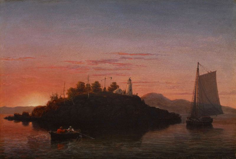
Inscribed verso (in infrared scan): View of Camden Mts. From Penobscot Bay
Historical Materials
The Camden Mountains, also called the Camden Hills, are located just northeast of the town of Camden. The range includes Mount Megunticook, upon whose shoulders Mount Battie sits, Cameron Mountain, and Bald Rock Mountain. They stand high above West Penobscot Bay between Camden and Lincolnville, looking east toward Mount Desert and the rising sun. The Wabenaki, loosely defined as the "people of the dawn," greeted their maritime world, "the dawn land," from the Camden Hills, and other high points, including Mount Wallamatogus in Penobscot (460 feet), Awan-adjo (at Bluehill), Caterpillar Hill in Sedgwick (with its panoramic sweep which stretches from the Camden Hills to Mount Desert and far out into Penobscot Bay), and atop Cadillac Mountain, Mount Desert. It is from the same peaks that artists and pilgrims alike still climb to view Penobscot Bay.
Mad-kam-ig-os'-sek, "big high land," is the Wabenaki word for Camden, and Meg-un-ti-cook, "big mountain harbor," the name for the harbor, is now used for Mount Megunticook. The inner harbor, quiet and safe, would have been the ideal place for a large, oceangoing canoe to lay up when the sea was rough. Capt. John Smith visited this place in 1614, during the Beaver Wars, and noted that the high mountains were used as a refuge from the Mik'maq of the Maritimes who fought the Wabenaki of Penobscot Bay to maintain their place as middlemen in the fur trade. These raiders would travel along the Downeast coast in their shallops. Mount Battie, of many spellings, was noted as Mount Betty in documents dating from 1757. It is a European corruption of a word borrowed from another place, the Madambettox Hills of Rockland.
-Mark Honey
References:
Eckstorm, Fannie Hardy, "Indian Place-Names of the Penobscot Valley and the Maine Coast," University of Maine Studies, 2nd Series, #55, November 1941, reprinted 1960 by the University of Maine Press. DeLorme's Atlas. Frank G Speck's "Penobscot Man," University Of Pennsylvania Press, 1940.
Newsprint
Gloucester Telegraph
"The Reef of Norman's Woe ... is now commemorated in painting too, one of the finest pictures from Lane's easel. ... The sketch was made at the pretty spot commonly called, we believe, Master Moore's Cove. Being some little way off the main track to Rafe's Chasm, it is seldom visited, except by the more inquisitive lovers of nature who leave the beaten road to pry out such pleasant places. ... We wish it might find a home buyer, rather than go off to enrich another community." Flowery description follows, then "There is another and larger work in the artist's studio, which, happily, is to be retained. It received much well deserved notice and commendation. The subject is a view southward from the 'Cut,' with the picturesque promontory commonly known as 'Stage Fort,' and historically interesting as the supposed spot of the 'Landing at Cape Ann' in the middle distance, and Eastern Point on the extreme left." More description follows, "Among other attractions of the studio, and particularly worthy of mention, is a cabinet picture with an effect similar to the Norman's Woe. The subject is chosen from the many sketches of the grand scenery of the Maine sea-coast with which the artist's portfolio is rich. It is a view of the Camden mountains sketches from the Graves, a jagged ledge far out in the bay, which is accessible in only the smoothest water."
Also filed under: Cut, The (Stacy Blvd.) » // Newspaper / Journal Articles » // The Graves »
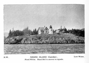
Curtis Island is located a short distance from Camden Harbor in Penobscot Bay. The island was known as Negro Island, from Revolutionary times to the 1930s, and in the early part of the nineteenth century as Mark Island. Abraham Ogier, in a deposition submitted in 1832, claimed that he had pastured hogs on the island and planted potatoes as early as 1773, and that he was driven off by the British in 1779. His grandson Lewis pastured sheep here for 40 years. The island was sold to the US government for a light station for $400 in 1835, and the Negro Island Light was established by an appropriation of $4500 in 1836. M.K.M. Bowers was the light keeper when Lane portrayed the island at dawn. The island was renamed Curtis Island in 1934 after Cyrus H.K. Curtis, publisher of the "Saturday Evening Post," a longtime summer resident and benefactor of Camden.
– Mark Honey
Reference:
McLane, Charles B, and McLane, Carol Evarts, "Islands of the Mid-Maine Coast," Penobscot Bay, Volume 1, Revised Edition, Tilbury House, Publishers, Gardiner, Maine, and the Island Institute, Rockland, Maine, page 124.
Photograph
From book "The Illustrated Coast Pilot with Sailing Directions. The Coast of New England from New York to Eastport, Maine including Bays and Harbors." Published by N.L. Stebbins, Boston, Mass. 1891
Also filed under: Camden, Maine – Negro (Curtis) Island Light »
Photograph
National Archives
Also filed under: Camden, Maine – Negro (Curtis) Island Light »
"Penobscot Bay is Maine's grandest stretch of water, and its largest, measuring 20 miles across from Whitehead Island to Isle au Haut and trending 30 miles north to the mouth of its equally superlative namesake river. Encompassing almost 1000 miles of shoreline and encircling 624 islands and ledges, Penobscot Bay is also the second-largest embayment on the east coast of the United States, after Chesapeake Bay. Giovanni da Verrazano, an early explorer, captivated by the site of the bay's channels and islands, wrote "all near the continent; small and pleasant in appearance, but high, following the curve of the land; some beautiful ports and channels are formed between them, such as those in the Adriatic Gulf in Illyria and Dalmatia…"
Penobscot Bay was, in every respect, a maritime community in the nineteenth century. The Island Kingdoms, with their cod fisheries, shipyards, and small farms, were tied commercially and economically to such large ports on the mainland as Rockland, Belfast, Bangor, Castine, and small ports of Mount Desert. The Islanders owned their own small fleets of coasters, finding cargo all along the coast, from the Maritimes to Portland and beyond. The glue that held this community together was family, extended family, there were no strangers in Penobscot Bay, among the coastal towns, or among the islands, for family members, as shipwrights, sailors, fishermen, merchants, and farmers, or by the simple act of marriage, formed close knit bonds which established a unique maritime culture.
– Mark Honey
References:
Conkling, Philip W, "Islands in Time," A Natural and Cultural History of the Islands of the Gulf of Maine, Island Institute, Rockland, and Downeast Books, Camden, page 64.
Honey, Mark E, "Abigail & Sarah Hawes of Castine," Navigators & Educators, with Lois Moore Cyr, 1996.
Honey, Mark E, "Before the Mast," Volume IV, articles 7-9, Holbrook Island and the Holbrook family, and in particular, Robert Applebee, "Vessels of the Penobscot Customs District," Stephan Phillips Memorial Library, Penobscot Marine Museum, Searsport, which source also has the diaries of Capt. Jonathan Holbrook and the genealogy of the Holbrook family in the Priscilla Jones collection. The "Before the Mass" series can be found in the collections of the Castine Historical Society and the Wilson Museum, both in Castine.
Honey, Mark E, "King Pine, Queen Spruce, Jack Tar," An Intimate History of Lumbering on the Union River, Volumes 1-5. This source, in its entirety, lays down the foundation of Downeast Maine's unique culture which was built upon pine lumber and timber, the cod fisheries, coasting, shipbuilding, and the interrelationships of family and community.
Jellison, Connee, "Hancock County," a rock found paradise, A Bicentennial Pictorial, The Donning Company, Norfolk, Virginia, 1990.
McLane, Charles B, and McLane, Carol Evarts, "Islands of the Mid-Maine Coast," Penobscot Bay, Volume 1, Revised Edition, Tilbury House, Publishers, Gardiner, Maine, and the Island Institute, Rockland, Maine.
McLane, Charles B, and McLane, Carol Evarts, "Islands of the Mid-Maine Coast," Mount Desert to Machias Bay, Volume 2, The Kennebec River club Press, Incorporated, Falmouth, 1989.
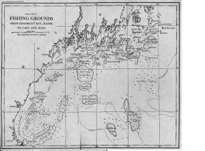
Chart
Fishery Industries of the United States, Sect. 3
Also filed under: Fishing »
Chart
U.S. Coast Survey
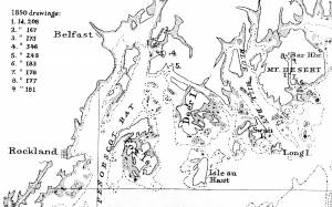
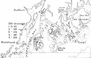
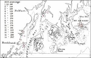
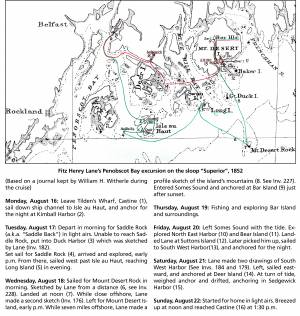
Chart with key showing the route of an excursion on the sloop "Superior" out of Castine made by William H. Witherle, Lane, Stevens and friends during which Lane made several sketches of Mt. Desert scenery. The trip was chronicled by Witherle in his diary of 1852.
View related catalogue entries (6) »
Also filed under: "Superior" (Sloop) » // Castine » // Mount Desert Island & Rock » // Southwest Harbor » // Witherle, William Howe »
Wilson Museum, Castine, Maine.
Library of Congress Catalog Number 2011588006
1860 map, including census of towns.
Also filed under: Castine » // Maps » // Mount Desert Island & Rock »
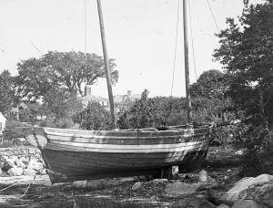
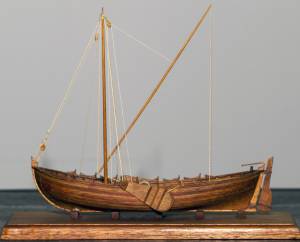
The colonial American shallop is the ancestor of many regional types of New England fishing craft found in Lane's paintings and drawings, including "New England Boats" (known as "boats"), and later descendents, such as "Chebacco Boats," "Dogbodies," and "Pinkies." (discussed elsewhere)
These boats were very common work boat types on Cape Ann throughout the 1800s. They were primarily used for inshore coastal fishing, which included lobstering, gill-netting, fish-trapping, hand-lining, and the like. They were usually sailed by one or two men, sometimes with a boy, and could be rowed as well as sailed. An ordinary catch would include rock cod, flounder, fluke, dabs, or other small flat fish. The catch would be eaten fresh, or salted and stored for later consumption, or used as bait fish. Gill-netting would catch herring and alewives when spawning. Wooden lobster traps were marked with buoys much as they are today, and hauled over the low sides of the boat, emptied of lobsters and any by-catch, re-baited and thrown back.
THE SHALLOP
Like other colonial vessel types, shallops were defined in many ways, including size, construction, and rig. Most commonly, they were open boats with square or sharp sterns, 20 to 30 feet in length, two-masted rigs, and heavy sawnframe construction which in time became lighter. (1)
The smaller shallops developed into a type called the Hampton Boat early in the nineteenth century, becoming the earliest named regional variant of what is now collectively termed the New England Boat. Other variants were named for their regions of origin: Isles of Shoals Boat, Casco Bay Boat, No Mans Land Boat, to name a few. No regional name for a Cape Ann version has survived, and "boat," or "two-masted boat" seems to have sufficed. (2)
Gloucester's New England Boats were mostly double-enders (sharp sterns) ranging in length from 25 to 30 feet, with two masts and two sails (no bowsprit or jib). They were used in the shore fisheries: handlining, gillnetting, and gathering or trapping shellfish (see View from Kettle Cove, Manchester-by-the-Sea, 1847 (inv. 94), View of Gloucester Harbor, 1848 (inv. 97), and /entry: 240/). (3)
Larger, double-ended shallops became decked and evolved in Ipswich (the part now called Essex) to become Chebacco Boats. (4) This variant retained the two-mast, two-sail rig, but evolved further, acquiring a bowsprit and jib and becoming known as a pinky (see Gloucester Harbor from Rocky Neck, 1844 (inv. 14), The Western Shore with Norman's Woe, 1862 (inv. 18), and The Old Fort and Ten Pound Island, Gloucester, 1850s (inv. 30)). The Chebacco Boat became a distinct type by the mid-eighteenth century giving rise to the pinky in the early ninetennth century; the latter, by the early 1900s. (5)
References:
1. William A. Baker, Sloops & Shallops (Barre, MA: Barre Publishing Co., 1966), 27–33; and “Vessel Types of Colonial Massachusetts,” in Seafaring in Colonial Massachusetts (Boston: The Colonial Society of Massachusetts, 1980), 13–15, see figs. 10, 11.
2. Howard I. Chapelle, American Small Sailing Craft (New York: W.W. Norton & Co., 1951), 136–45.
3. Ibid., 145, upper photo, fourth page of plates.
4. Baker, 82–91.
5. Chapelle, The American Fishing Schooners, 1825–1935 (New York: W.W. Norton & Co., 1973), 23–54.
THE NEW ENGLAND BOAT
By the 1840s, the Gloucester version of the New England Boat had evolved into a distinct regional type. Referred to locally as “boats,” the most common version was a double-ender, i.e. having a pointed stern, unlike the less common version having a square stern.
Both variants had two masts, a foresail, a mainsail, but no bowsprit or jib. Lane depicted both in several paintings, beginning in the mid-1840s (see View from Kettle Cove, Manchester-by-the-Sea, 1847 (inv. 94), View of Gloucester Harbor, 1848 (inv. 97), and /entry: 240/), all ranging 25 to 30 feet in length. In View of Gloucester Harbor, 1848 (inv. 97) and Gloucester Inner Harbor, 1850 (inv. 240), a double-ender can be seen on the beach while a square-stern version lies at anchor in the harbor, just to the right of the former. (1)
Lane’s depictions of the double-enders show lapstrake hull planking in View of Gloucester Harbor, 1848 (inv. 97) and Gloucester Inner Harbor, 1850 (inv. 240), and cuddies (short decking) inboard at the ends for shelter and stowage of fishing gear in View from Kettle Cove, Manchester-by-the-Sea, 1847 (inv. 94). The few square-stern examples (see View of Gloucester Harbor, 1848 (inv. 97) and Gloucester Inner Harbor, 1850 (inv. 240)) suggest carvel (smooth) planking and paint finish, rather than oil and tar. The presence of an example of the latter variant in Boston Harbor, as noted in Boston Harbor, c.1850 (inv. 48), suggests a broader geographical range for this subtype. (2)
The primary use of Cape Ann’s “boats” was fishing, making “day trips” to coastal grounds for cod, herring, mackerel, hake, flounder, and lobster, depending on the season. Fishing gear included hooks and lines, gill nets, and various traps made of wood and fish net.
Some boats worked out of Gloucester Harbor, but other communities on Cape Ann had larger fleets, such as Sandy Bay, Pigeon Cove, Folly Cove, Lanesville, Bay View, and Annisquam. Lane’s depictions of these places and their boats are rare to nonexistent. (3)
The double-ended boat served Lane in marking the passage of time in Gloucester Harbor. In View from Kettle Cove, Manchester-by-the-Sea, 1847 (inv. 94), we see new boats setting out to fish, but in View of Gloucester Harbor, 1848 (inv. 97) and Gloucester Inner Harbor, 1850 (inv. 240), a boat of the same type is depicted in a progressively worn state. In Stage Fort across Gloucester Harbor, 1862 (inv. 237), the boat is a stove hulk on a beach, and in the same year, Lane depicted the type’s shattered bottom frame and planking lying on the shore at Norman’s Woe in Norman's Woe, Gloucester Harbor, 1862 (inv. 1).
Regional variants of the New England Boat appear in Lane’s paintings of Maine harbors, including one and two-masted versions, collectively called Hampton Boats (see Bear Island, Northeast Harbor, 1855 (inv. 24), Ten Pound Island at Sunset, 1851 (inv. 25), Fishing Party, 1850 (inv. 50), Father's (Steven's) Old Boat, 1851 (inv. 190), and "General Gates" at Anchor off Our Encampment at Bar Island in Somes Sound, Mount Desert, Maine, 1850 (inv. 192)). Some distinctive regional types were given names, i.e. Casco Bay Boats ("General Gates" at Anchor off Our Encampment at Bar Island in Somes Sound, Mount Desert, Maine, 1850 (inv. 192) may be one), but many local type names, if they were coined, have been lost. (4)
References:
1. Howard I. Chapelle, American Small Sailing Craft (New York: W.W. Norton & Co., 1951), 141–42.
2. Ibid., 152–55.
3. Sylvanus Smith, Fisheries of Cape Ann (Gloucester, MA: Press of the Gloucester Times, 1915), 96–97, 102–05, 110–13.
4. Chapelle, 152–55.
Also filed under: Ship Models »
Also filed under: Ship Models »
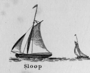
Sloops are one-masted sailing vessels which, in American examples, set fore-and-aft sails but usually no square sails. Thus, staysails, or jibs, are set from the fore stay(s) and a quadrilateral mainsail is set from the mast and spread by a gaff and a boom. The larger sloops would often set a triangular topsail over the main sail. (1)
The sloops depicted by Lane were used in various coastal trades, each with its own requirements, which dictated the sizes and details of their hulls and rigs. Most elegant were the packet sloops, which transported passengers, mail, and higher value goods between specific ports on regular schedules. They usually measured between sixty and seventy-five feet on deck, as dictated by anticipated shipping volume. Finely finished, they usually had stern galleries—a row of windows across the transom with ornamental moldings—and varied color schemes. Examples of packet sloops are in Gloucester Harbor from Rocky Neck, 1844 (inv. 14) (center, middle ground) and Study of Ships, 1851 (inv. 141) (foreground), both of which probably made trips between Gloucester and Boston, or Gloucester and Newburyport. (2)
Another specialized sloop of similar size was the stone sloop, used to ship granite blocks from stone-loading piers around Cape Ann to other ports. They were similar in rig to packet sloops, but of heavier construction with greater hold capacity and absence of decoration. Their stout appearance was augmented by simple color schemes, or even tarred topsides, reflecting the wear and strain imposed by their heavy cargos. Lane depicted these vessels in his painting of Fresh Water Cove from Dolliver's Neck, Gloucester, Early 1850s (inv. 45), with a sloop (at left) preparing to load at wharf-side, and another (at right) sailing out with a cargo. (3)
Sloops of the more work-a-day sort are the most commonly seen examples in Lane’s paintings, most of them appearing in his views of Boston Harbor. Usually deep-loaded and looking weather-worn, they contrast sharply with the packet- and clipper ships which dominate the scene. Sloops of this type are rarely seen in Lane’s paintings of Gloucester Harbor and the Maine coast, although they were certainly needed for short-distance transportation (see Bear Island, Northeast Harbor, 1855 (inv. 24), View of Camden Mountains from Penobscot Bay, c.1852 (inv. 207), Sunrise on the Maine Coast, Mount Desert Island, 1856 (inv. 295)). For coastal Maine, lack of railroads for heavier freight and greater distances between ports made the use of schooners with larger carrying capacity a greater necessity. (4)
In Lane’s views of New York Harbor, a regional sloop variant, the Hudson River Sloop, appears in New York Harbor, c.1855 (inv. 46) (bow view, left) and A Calm Sea, c.1860 (inv. 6) (stern view, right). This type had become prominent in the Hudson River packet trade between New York City, Albany, and beyond to points north and west as far as the eastern terminus of the Erie Canal. Large vessels for their rigs, they were well-finished and well-kept, reflecting pride of ownership and rivalry among their owners and crews. (5)
– Erik Ronnberg
References:
1. A Naval Encyclopaedia (Philadelphia: L.R. Hamersly & Co., 1884. Reprint: Detroit, MI: Gale Research Company, 1971), 59. See first definition of "sloop" and definition of "sloop-rigged."
2. Robert Greenhalgh Albion, William A. Baker, and Benjamin Woods Labaree, New England and the Sea (Mystic, CT: Mystic Seaport Museum, 1972; reprinted in 1994), 127–28.
3. Howard I. Chapelle, The History of American Sailing Ships (New York: W.W. Norton & Co., 1935), 300–02.
4. Ibid., 300.
5. Ibid., 298–300.
A Naval Encyclopaedia:
Dictionary of nautical words and phrases
Special Articles on Naval Art and Science
Philadelphia: L.R. Hamersly & Co.
'Mudian, "Mugian, or Bermudian. A boat special to the Bermuda islands, usually decked, with the exception of a hatch; from 2 to 20 tons burden; it is short, of good beam, and great draft of water abaft, the stem and keel forming a curved line. It carries an immense quantity of ballast. Besides a long main- and short jib-boom, it has a long, taperking, raking mast, stepped just over the forefoot, generally unsupported by shrouds or stays; on it a jib-headed mainsail is hoisted to a height of twice, and sometimes three times, the length of the keel. This sail is triangular, stretched at its foot by a long boom. The only other sail is a small foresail or jib. They claim to be the fastest craft in the world for working to windward in smooth water, it being recorded of one that she made five miles dead to windward in the hour during a race; and though they may be laid over until they fill with water, they will not capsize.
St. George's Historical Society
Detail of painting of St. George's Harbour, Bermuda, during US Civil War, with a Confederate blockade runner anchored in the foreground.
Also filed under: Puerto Rico »
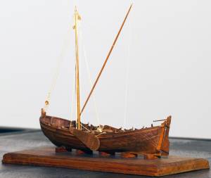
Wood, metal, cordage, cloth, paint.
Scale: ¼ in. = 1ft. (1:48)
Cape Ann Museum. Gift of Roland and Martta Blanchet (1997.17.3)
Although built in 1890 and larger than the stone sloops of Lane’s time, the "Albert Baldwin’s" hull form, rig, and loading boom are very similar to those of the 1840s and 1850s.
Also filed under: Granite Quarrying / Shipping » // Ship Models »

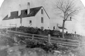
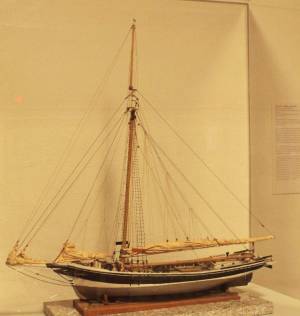
The Curtis Island Light is located on the seven-acre Curtis Island, a short distance off the coastline of Camden, Maine in the Penobscot Bay. The island was formerly known as Negro Island because the African-American cook of early settler, James Richards, admired the island greatly, but was later named Curtis Island in memory of Camden summertime resident, Cyrus H. K. Curtis. The original lighthouse was built in 1835 by contractor George Gault. Fifteen years later, an inspection report from 1850 stated that the lighthouse needed "immediate attention" and in 1855 the lighthouse was given a wooden outer sheath and new shingling in an attempt to stop the leaks. Lane painted the Curtis Island Light on at least two separate occasions, in 1852 and 1855, during his trips to the Maine coast.
This is information has been shared with the Lane project by Jeremy D'Entremont. More information can be found on his website, www.newenglandlighthouses.net and in his book The Lighthouse Handbook of New England.
Photograph
From book "The Illustrated Coast Pilot with Sailing Directions. The Coast of New England from New York to Eastport, Maine including Bays and Harbors." Published by N.L. Stebbins, Boston, Mass. 1891
Also filed under: Negro (Curtis) Island, Camden Harbor »
Photograph
National Archives
Also filed under: Negro (Curtis) Island, Camden Harbor »