An online project under the direction of the CAPE ANN MUSEUM
Catalogue Entry
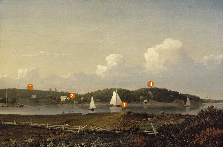
Fresh Water Cove, located on the Western Shore of Gloucester Harbor, is closely associated with the early history of Cape Ann and with the Sawyer family. After the Dorchester Company had failed to establish a viable outpost at Gloucester in 1623, members of the fledgling colony moved to nearby Salem, Massachusetts. By the early 1650s, families began venturing back to Cape Ann, settling in various spots across the rugged landscape. Sites were selected if they offered some advantage to the settlers: fertile ground, access to navigable waters, or proximity to pathways and rudimentary roads.
Fresh Water Cove had several attributes, including a spring that yielded potable water, access to a way that led back towards Salem, and an inlet sheltered from the open ocean by Dolliver’s Neck. Early in the history of Gloucester, a public right-of-way to the water was laid out at Fresh Water Cove, assuring that all would have the right to access Gloucester Harbor from that point.
The Sawyer family was amongst the earliest to settle in Gloucester and one of the first to take up residence at Fresh Water Cove. Samuel Sawyer (1815–1889), who spent his winters in Boston and his summers at the Cove, was one of Fitz Henry Lane’s patrons. He represented the fifth generation of the family to live at Fresh Water Cove in the ancestral home, Brookbank.
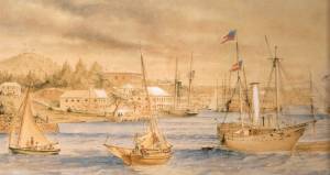
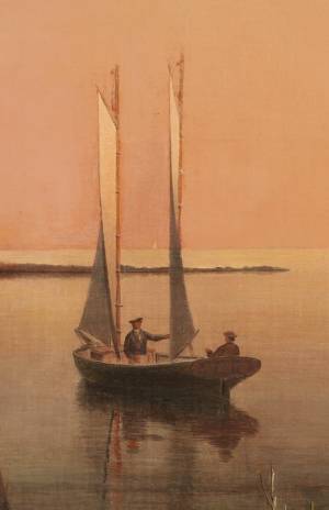
In this painting, Lane has shown Fresh Water Cove and Brookbank as seen from Dolliver’s Neck. The painting is invested with a wealth of narrative detail. To the far left, a sturdy wharf can be seen, with a tall slender derrick rising above it. This is where granite, harvested from a quarry upland from the Cove, was loaded aboard sloops like the one shown at the wharf. From there, the stone was transported to Boston and other ports. A second, more substantial derrick can be seen jutting out of the tree line above Sawyer’s Hill. This indicates the location of this quarry—one of the first to be opened up on Cape Ann.
Brookbank is the yellow gambrel-roofed house with a widow’s walk on the roof. To the right, just visible through the trees, is a barn that belonged to the property, and in the foreground is a boathouse perched above the rocks on stone pilings. Lane included a parade of five other vessels in the painting in addition to the sloop secured to the wharf: a wherry being rowed by a lone man; a small sloop with its sail down being poled by two men (one of whom is wearing a red shirt); a larger sloop, perhaps a pleasure craft, with all its sails set heading away from the artist; a stone sloop with a topmast flying a red pennant; and on the far right, a small schooner just heading into Fresh Water Cove.
As a whole, the scene is a peaceful yet productive one.
– Martha Oaks
- Subject Types
: - Vessel Types
: - Cape Ann Locales
: - Objects
:
Historical Materials
Brookbank was an early eighteenth-century white gambrel-roofed house on Fresh Water Cove which was owned and occupied by Samuel Sawyer and his ancestors. It is possible to trace apparent renovations to the house through Lane's pictures; at first it is depicted as a white house without dormers and a simple brown barn Fresh Water Cove, Gloucester, c.1864 (inv. 112); then dormers appear on the house and the barn is white with a cupola Fresh Water Cove, etc., from Dolliver's Neck, 1850s (inv. 113). In Gloucester from Brookbank, 1848 (inv. 42) a cobb wharf (log cabin-like structure) and boardwalk are visible. By Fresh Water Cove from Dolliver's Neck, Gloucester, Early 1850s (inv. 45) the house seems to have additions.
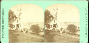
Stereograph card Cape Ann Museum Library & Archive
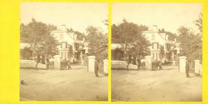
Stereo view of Brookbank guest house or boathouse.
Also filed under: Historic Photographs »
Published by Frank Rowell Cape Ann Museum Library & Archive
Stereograph card
Also filed under: Historic Photographs »
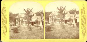
n.d. Stereographic card Cape Ann Museum Library & Archive
Penciled on reverse: "Mansion House, Brook Bank [sic], Sam'l Sawyer now Hammond, Freshwater Cove"
Also filed under: Historic Photographs » // Sawyer, Samuel »

44 x 34 in.
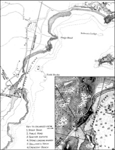
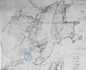
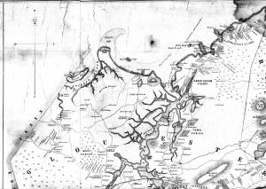
Henry Francis Walling, Map of the Towns of Gloucester and Rockport, Essex Co. Massachusetts. Philadelphia, A. Kollner, 1851
Cape Ann Museum Library & Archive
"Map of the Towns of Gloucester and Rockport, Massachusetts. H.F. Walling, Civil Engineer. John Hanson, Publisher. 1851. Population of Gloucester in 1850: 7,805. Population of Rockport in 1850: 3,213."
Also filed under: Annisquam River » // Dolliver's Neck » // Fresh Water Cove » // Gloucester Harbor, Outer » // Maps » // Norman's Woe » // Stage Rocks / Stage Fort / Stage Head » // Steepbank » // West Gloucester – Little River » // Western Shore »
Samuel Sawyer Papers
Cape Ann Museum Library & Archives
Archive Collection
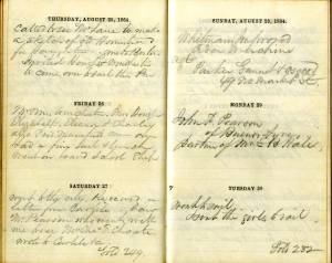
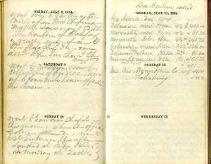
"August 25. Called to see Mr. Lane to make a sketch of old Homestead for Haughtons."
Also filed under: Diaries / Ledgers / Etc. » // Haughton, James » // Sawyer, Samuel »
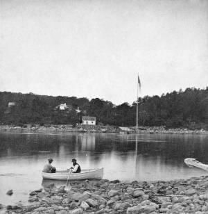
1860s Stereograph card Cape Ann Museum Library & Archive
A view of a Cove on the western side of Gloucester Harbor, with the landing at Brookbank. Houses are seen in the woods back. A boat with two men is in the foreground.
Also filed under: American ensign / flag » // Fresh Water Cove » // Historic Photographs »
Stereograph card
Cape Ann Museum Library & Archive
Also filed under: Fresh Water Cove »
Lane did a remarkable series of paintings from Brookbank, the Sawyer homestead, which overlooks Fresh Water Cove. They show Dolliver’s Neck and how it protects the cove from the harbor. It is also visible in Dolliver's Neck and the Western Shore from Field Beach, 1857 (inv. 3), though somewhat disguised by the rest of the western shore in that view. He did a drawing and painting from Dolliver’s Neck looking west in Fresh Water Cove from Dolliver's Neck, Gloucester, Early 1850s (inv. 45).
Dolliver’s Neck is a small arm of land pointing north off the western shore of the Gloucester’s Outer Harbor. It is the cradling arm that creates Fresh Water Cove, a small cove where Samuel de Champlain found fresh water on his first visit to Gloucester Harbor in 1606. It was named for Samuel Dolliver who came from Marblehead in 1652 and bought a farm there.
In Lane’s time there were a few fishing shacks visible in some of his paintings where onshore fishermen could put their boats in from the pebble beach and salt marsh and be out in the center of the harbor without the long row or sail from the Inner Harbor. Fresh Water Cove itself is not deep enough at low tide for larger vessels to moor there so it has retained its small scale and intimate feel down through the years.
In 1900 a Coast Guard lifesaving station was built and manned on Dolliver’s Neck and many lives were saved along that rocky and treacherous coast between Gloucester and Magnolia.
Newsprint
From bound volume owned by publisher Francis Procter
Collection of Fred and Stephanie Buck
"We visited the studio of Mr. Fitz H. Lane a few days since, and were much pleased in examining some fine paintings from the pencil of this talented artist. Among the collection was a view of Long Beach, in this town, with which we were particularly interested.
The scene is taken immediately after a storm. The waves with their snowy crests are rolling in upon the beach, breaking against the sides of a vessel which has been driven ashore. In the background is seen the residence of Mr. Fessenden, and the surrounding scenery; on the right are visible the high headlands near the residence of Mr. Geo. Hovey, while stretching far away in the distance may be seen Fresh Water Cove, Dolliver's Neck, and the Old Pine Tree, the whole forming a beautiful picture and true to Nature.
Several other paintings were in process of completion, one a beautiful sunset scene, which was really beautiful to gaze upon; also a view of a gale at sea, with a gallant ship plunging madly through the waves, forming a striking contrast to the mild placid scene of the picture at its side.
Mr. Lane's paintings are true to nature, and in viewing them one can but admire the skill and genius of this talented artist, We advise all lovers of the art, who wish to spend an hour pleasantly, to visit the studio of Mr. Lane on Locust St. We can assure them that they will come away highly gratified, and have an earnest desire to call again." (1)
(1) See p. 2, column 3, Courtesy of the American Antiquarian Society
Also filed under: Chronology » // Fessenden, C. B. » // Fresh Water Cove » // Lone Pine » // Newspaper / Journal Articles » // Steepbank » // Studio Descriptions »
44 x 34 in.
Henry Francis Walling, Map of the Towns of Gloucester and Rockport, Essex Co. Massachusetts. Philadelphia, A. Kollner, 1851
Cape Ann Museum Library & Archive
"Map of the Towns of Gloucester and Rockport, Massachusetts. H.F. Walling, Civil Engineer. John Hanson, Publisher. 1851. Population of Gloucester in 1850: 7,805. Population of Rockport in 1850: 3,213."
Also filed under: Annisquam River » // Brookbank » // Fresh Water Cove » // Gloucester Harbor, Outer » // Maps » // Norman's Woe » // Stage Rocks / Stage Fort / Stage Head » // Steepbank » // West Gloucester – Little River » // Western Shore »

Engraving of 1819 survey taken from American Coast Pilot 14th edition
9 1/2 x 8 in.
Cape Ann Museum Library & Archive
D32 FF5
Also filed under: Eastern Point » // Maps » // Norman's Woe » // Ten Pound Island »
Newspaper
"Mr. Lane has just completed a third picture of the Western Shore of Gloucester Harbor, including the distance from 'Norman's Woe Rock' to 'Half Moon Beach.' It was painted for Mr. William E. Coffin of Boston, and will be on exhibition at the artist's rooms for only a few days; we advise all our readers who admire works of art, and would see one of the best pictures Mr. Lane has ever executed..."
"...solitary pine, so many years a familiar object and landmark to the fisherman."

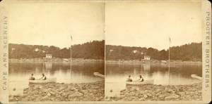
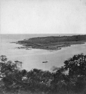
c.1860 Stereograph card Cape Ann Museum Library & Archive
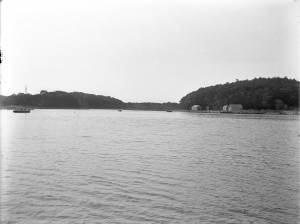
Taken from Steepbank, on the western side of Gloucester Harbor, and showing a small boat at anchor in the cove, then the Neck, and the sea beyond.
Also filed under: Fresh Water Cove » // Historic Photographs » // Lone Pine » // Steepbank »
1860s Stereograph card Cape Ann Museum Library & Archive
"Cape Ann Scenery, John S. E. Rogers, Low's Block. #54 Dolliver's Neck. Taken from Steepbank, on the western side of Gloucester Harbor, and showing a small boat at anchor in the cove, then the Neck and the sea beyond."
Also filed under: Historic Photographs »
4 x 5 in.
Cape Ann Museum Library & Archive
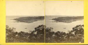
Freshwater Cove and Dolliver's Neck from the water off Stage Fort.
Also filed under: Fresh Water Cove »
The owner of this flagpole has not been determined, but it is an interesting landmark in Lane's paintings. Often it appears in his drawings and not in his paintings, and Western Shore of Gloucester Outer Harbor, 1857 (inv. 107) contains the only image of a flag actually flying from the pole.
Fresh Water Cove is located on the west side of Gloucester’s Outer Harbor. It is protected from the harbor waters and the south-easterly seas by the arm of Dolliver’s Neck reaching north from the western shore. It’s a small, very still cove, only a few hundred yards from its mouth to the innermost shore.
The cove was visited by Samuel de Champlain in 1606. He was the first known European to enter Gloucester Harbor, which he named Le Beauport. He named Fresh Water Cove for the fresh water springs he found there, one a bit up from the shore, the other flowing below the high tide line and only accessible at half tide.
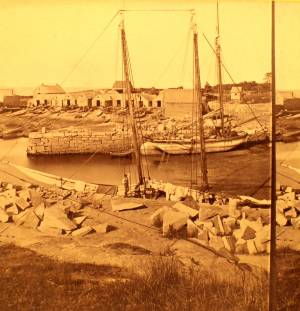
The cove, while very well protected from the weather, is small and very shallow at low tide and was never suitable for any large vessels, though there were fishing shacks along the shores edge and small boats were easily pulled up on the sand and salt marsh in its inner recesses. There was a wharf built in the early 1800s to service a granite quarry just up the hill from the cove, which could apparently handle larger vessels at high tide.
In Lane’s time, the most significant landmark from the cove was Brookbank, the Sawyer homestead where Samuel E. Sawyer was born in 1818. Sawyer made a fortune in Boston and returned to Brookbank every summer for fifty years. He became one of Gloucester’s first philanthropists. Lane did a series of paintings from the fields in front of Brookbank looking to the east from the house over Fresh Water Cove, the arm of Dolliver’s Neck and the harbor beyond. He also painted the opposite view in Fresh Water Cove from Dolliver's Neck, Gloucester, Early 1850s (inv. 45) looking west from Dolliver’s Neck over the cove to the Sawyer homestead and surrounding shoreline. Each of these paintings captures the perfect serenity of a high summer day in this secluded cove just off the busy harbor.
Stereograph card
Cape Ann Museum Library & Archive
Also filed under: Brookbank »
44 x 34 in.
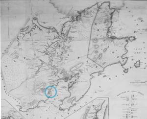
Henry Francis Walling, Map of the Towns of Gloucester and Rockport, Essex Co. Massachusetts. Philadelphia, A. Kollner, 1851
Cape Ann Museum Library & Archive
"Map of the Towns of Gloucester and Rockport, Massachusetts. H.F. Walling, Civil Engineer. John Hanson, Publisher. 1851. Population of Gloucester in 1850: 7,805. Population of Rockport in 1850: 3,213."
Also filed under: Annisquam River » // Brookbank » // Dolliver's Neck » // Gloucester Harbor, Outer » // Maps » // Norman's Woe » // Stage Rocks / Stage Fort / Stage Head » // Steepbank » // West Gloucester – Little River » // Western Shore »
c.1860 Stereograph card Cape Ann Museum Library & Archive
Taken from Steepbank, on the western side of Gloucester Harbor, and showing a small boat at anchor in the cove, then the Neck, and the sea beyond.
Also filed under: Dolliver's Neck » // Historic Photographs » // Lone Pine » // Steepbank »
Newspaper
"Mr. Lane has just completed a third picture of the Western Shore of Gloucester Harbor, including the distance from 'Norman's Woe Rock' to 'Half Moon Beach.' It was painted for Mr. William E. Coffin of Boston, and will be on exhibition at the artist's rooms for only a few days; we advise all our readers who admire works of art, and would see one of the best pictures Mr. Lane has ever executed..."
"...solitary pine, so many years a familiar object and landmark to the fisherman."
Newsprint
From bound volume owned by publisher Francis Procter
Collection of Fred and Stephanie Buck
"We visited the studio of Mr. Fitz H. Lane a few days since, and were much pleased in examining some fine paintings from the pencil of this talented artist. Among the collection was a view of Long Beach, in this town, with which we were particularly interested.
The scene is taken immediately after a storm. The waves with their snowy crests are rolling in upon the beach, breaking against the sides of a vessel which has been driven ashore. In the background is seen the residence of Mr. Fessenden, and the surrounding scenery; on the right are visible the high headlands near the residence of Mr. Geo. Hovey, while stretching far away in the distance may be seen Fresh Water Cove, Dolliver's Neck, and the Old Pine Tree, the whole forming a beautiful picture and true to Nature.
Several other paintings were in process of completion, one a beautiful sunset scene, which was really beautiful to gaze upon; also a view of a gale at sea, with a gallant ship plunging madly through the waves, forming a striking contrast to the mild placid scene of the picture at its side.
Mr. Lane's paintings are true to nature, and in viewing them one can but admire the skill and genius of this talented artist, We advise all lovers of the art, who wish to spend an hour pleasantly, to visit the studio of Mr. Lane on Locust St. We can assure them that they will come away highly gratified, and have an earnest desire to call again." (1)
(1) See p. 2, column 3, Courtesy of the American Antiquarian Society
Also filed under: Chronology » // Dolliver's Neck » // Fessenden, C. B. » // Lone Pine » // Newspaper / Journal Articles » // Steepbank » // Studio Descriptions »
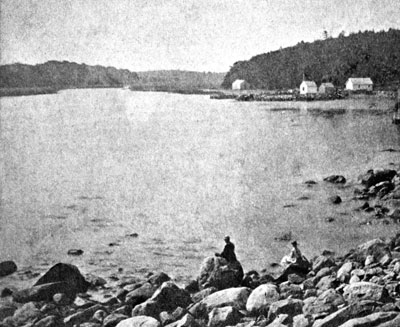
1860s Stereograph card Cape Ann Museum Library & Archive
A view of a Cove on the western side of Gloucester Harbor, with the landing at Brookbank. Houses are seen in the woods back. A boat with two men is in the foreground.
Also filed under: American ensign / flag » // Brookbank » // Historic Photographs »
4 x 5 in.
Cape Ann Museum Library & Archive
Freshwater Cove and Dolliver's Neck from the water off Stage Fort.
Also filed under: Dolliver's Neck »
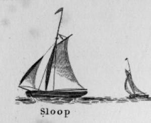
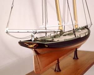
Sloops are one-masted sailing vessels which, in American examples, set fore-and-aft sails but usually no square sails. Thus, staysails, or jibs, are set from the fore stay(s) and a quadrilateral mainsail is set from the mast and spread by a gaff and a boom. The larger sloops would often set a triangular topsail over the main sail. (1)
The sloops depicted by Lane were used in various coastal trades, each with its own requirements, which dictated the sizes and details of their hulls and rigs. Most elegant were the packet sloops, which transported passengers, mail, and higher value goods between specific ports on regular schedules. They usually measured between sixty and seventy-five feet on deck, as dictated by anticipated shipping volume. Finely finished, they usually had stern galleries—a row of windows across the transom with ornamental moldings—and varied color schemes. Examples of packet sloops are in Gloucester Harbor from Rocky Neck, 1844 (inv. 14) (center, middle ground) and Study of Ships, 1851 (inv. 141) (foreground), both of which probably made trips between Gloucester and Boston, or Gloucester and Newburyport. (2)
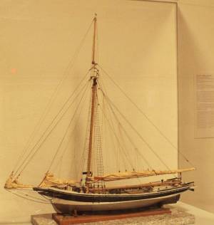
Another specialized sloop of similar size was the stone sloop, used to ship granite blocks from stone-loading piers around Cape Ann to other ports. They were similar in rig to packet sloops, but of heavier construction with greater hold capacity and absence of decoration. Their stout appearance was augmented by simple color schemes, or even tarred topsides, reflecting the wear and strain imposed by their heavy cargos. Lane depicted these vessels in his painting of Fresh Water Cove from Dolliver's Neck, Gloucester, Early 1850s (inv. 45), with a sloop (at left) preparing to load at wharf-side, and another (at right) sailing out with a cargo. (3)
Sloops of the more work-a-day sort are the most commonly seen examples in Lane’s paintings, most of them appearing in his views of Boston Harbor. Usually deep-loaded and looking weather-worn, they contrast sharply with the packet- and clipper ships which dominate the scene. Sloops of this type are rarely seen in Lane’s paintings of Gloucester Harbor and the Maine coast, although they were certainly needed for short-distance transportation (see Bear Island, Northeast Harbor, 1855 (inv. 24), View of Camden Mountains from Penobscot Bay, c.1852 (inv. 207), Sunrise on the Maine Coast, Mount Desert Island, 1856 (inv. 295)). For coastal Maine, lack of railroads for heavier freight and greater distances between ports made the use of schooners with larger carrying capacity a greater necessity. (4)
In Lane’s views of New York Harbor, a regional sloop variant, the Hudson River Sloop, appears in New York Harbor, c.1855 (inv. 46) (bow view, left) and A Calm Sea, c.1860 (inv. 6) (stern view, right). This type had become prominent in the Hudson River packet trade between New York City, Albany, and beyond to points north and west as far as the eastern terminus of the Erie Canal. Large vessels for their rigs, they were well-finished and well-kept, reflecting pride of ownership and rivalry among their owners and crews. (5)
– Erik Ronnberg
References:
1. A Naval Encyclopaedia (Philadelphia: L.R. Hamersly & Co., 1884. Reprint: Detroit, MI: Gale Research Company, 1971), 59. See first definition of "sloop" and definition of "sloop-rigged."
2. Robert Greenhalgh Albion, William A. Baker, and Benjamin Woods Labaree, New England and the Sea (Mystic, CT: Mystic Seaport Museum, 1972; reprinted in 1994), 127–28.
3. Howard I. Chapelle, The History of American Sailing Ships (New York: W.W. Norton & Co., 1935), 300–02.
4. Ibid., 300.
5. Ibid., 298–300.
A Naval Encyclopaedia:
Dictionary of nautical words and phrases
Special Articles on Naval Art and Science
Philadelphia: L.R. Hamersly & Co.
'Mudian, "Mugian, or Bermudian. A boat special to the Bermuda islands, usually decked, with the exception of a hatch; from 2 to 20 tons burden; it is short, of good beam, and great draft of water abaft, the stem and keel forming a curved line. It carries an immense quantity of ballast. Besides a long main- and short jib-boom, it has a long, taperking, raking mast, stepped just over the forefoot, generally unsupported by shrouds or stays; on it a jib-headed mainsail is hoisted to a height of twice, and sometimes three times, the length of the keel. This sail is triangular, stretched at its foot by a long boom. The only other sail is a small foresail or jib. They claim to be the fastest craft in the world for working to windward in smooth water, it being recorded of one that she made five miles dead to windward in the hour during a race; and though they may be laid over until they fill with water, they will not capsize.
St. George's Historical Society
Detail of painting of St. George's Harbour, Bermuda, during US Civil War, with a Confederate blockade runner anchored in the foreground.
Also filed under: Puerto Rico »
Wood, metal, cordage, cloth, paint.
Scale: ¼ in. = 1ft. (1:48)
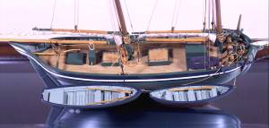
Cape Ann Museum. Gift of Roland and Martta Blanchet (1997.17.3)
Although built in 1890 and larger than the stone sloops of Lane’s time, the "Albert Baldwin’s" hull form, rig, and loading boom are very similar to those of the 1840s and 1850s.
Also filed under: Granite Quarrying / Shipping » // Ship Models »

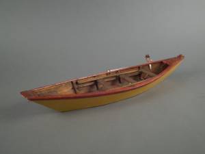
The term “wherry”—variously spelled—has a long history with many hull types, some dating from the fifteenth century. (1) The version known to Lane appears to be a variant of the dory hull form and probably was developed by French and English fishermen in the Newfoundland fisheries before 1700. (2) From that time, the wherry and the dory co-evolved, their similarities the result of their construction, their differences the result of use. By the early nineteenth century, their forms reached their final states, if fragments of contemporary descriptions are any indication. (3)
By the time Lane was depicting wherries, the type (as used for fishing) resembled a larger, wider version of a dory. The extra width was due to greater bottom width (both types had flat bottoms), with a wider transom at the stern instead of the narrow, v-shaped “tombstone.” These features are easy to see in one of his drawings (see Three Men, One in a Wherry, n.d. (inv. 225)) and a painting (see Sunrise through Mist, 1852 (inv. 98)), the latter depicted alongside a dory, clearly showing the differences.
No published descriptions of the uses of wherries on Cape Ann in Lane’s time have come to light, but an example in broadside view offers one use. In Becalmed Off Halfway Rock, 1860 (inv. 344), a pinky (in right foreground) has a dory and a wherry in tow, the latter loaded with a gill net for catching mackerel. (4) The greater size of the wherry is required for stowing the net, as well as setting it while the dory tows away one end to set it in way of the mackerel school.
In Lane’s time, wherries would have been used where bulky gear was called for in the coastal fisheries, i.e. gill nets, and fish traps such as pound nets, fyke nets, and lobster traps. Migrating fish schools (herring, mackerel) and shellfish were the target species.
The dory’s development was first dictated by its use in shore fishing, where small size and light weight made it easy to maneuver around rocks and shallows, and to haul ashore at the end of a day’s work. Its simple design made it easy and cheap to build. This is borne out by the standardized construction and sizes used by Simon Lowell’s boat shop at Salisbury Point, Massachusetts at the turn of the nineteenth century. Lowell called his boats “wherries,” but in Swampscott, Massachusetts, the fishermen, who used them called them “dories,” which may mark the beginning of the latter term’s wider use. (5)
The dories we see in Lane’s paintings are in virtually every way like the ones we know today. One of the best examples (see View from Kettle Cove, Manchester-by-the-Sea, 1847 (inv. 94)) even shows interior detail, including frames, leaving no doubt about its construction. Other good examples are found in Salem Harbor, 1853 (inv. 53), View of Gloucester Harbor, 1848 (inv. 97), and Sunrise through Mist, 1852 (inv. 98).
For inshore fishing, dories were used to catch mackerel and herring, either with hook and line or with small nets. Hooks and line were used for flat fish (flounder, dab, and fluke), rock cod, hake, and cunner. Eels were speared (see View from Kettle Cove, Manchester-by-the-Sea, 1847 (inv. 94)), clams were dug, and lobsters trapped. In Lane’s later years, the use of dories in trawling (setting long “trawl lines” with many baited hooks) was in its earliest. This method required six to ten dories carried on board a schooner to fish on the distant banks off New England and Canada. Early records of dory trawling in New England are fragmentary, giving the mid-1840s as the time of introduction. (6) The Gloucester-owned schooner "Anna" made a successful dory trawling trip to the Grand Banks in 1854, but no depiction of this vessel by Lane has been found or recorded. (5) Despite successful early efforts, dory trawling from Gloucester was slow to be accepted, and the fishery had very limited growth prior to 1860. (7)
– Erik Ronnberg
References:
1. M.H. Parry et al., Aak to Zumbra (Newport News, VA: The Mariners’ Museum, 2000), 634.
2. John Gardner, The Dory Book (Camden, ME: International Marine Publishing Company, 1978), 5–9.
3. Ibid., 25–29.
4. John Wilmerding, ed., Paintings by Fitz Hugh Lane (Washington, DC: National Gallery of Art, 1988), 89, 92. The “possibly discarded whaleboat” is definitely a wherry.
5. Gardner, 9, 10.
6. Wesley George Pierce, Goin’ Fishin’ (Salem, MA: Marine Research Society, 1934), 63–64.
7. Raymond McFarland, A History of New England Fisheries (Philadelphia: University of Pennsylvania, 1911), 279.

c.1870 Stereograph card Procter Brothers, Publisher Cape Ann Museum Library & Archive
"Gloucester Harbor from Rocky Neck, Looking Southwest. This gives a portion of the Harbor lying between Ten Pound Island and Eastern Point. At the time of taking this picture the wind was from the northeast, and a large fleet of fishing and other vessels were in the harbor. In the range of the picture about one hundred vessels were at anchor. In the small Cove in the foreground quite a number of dories are moored. Eastern Point appears on the left in the background."
Southeast Harbor was known for being a safe harbor.
Also filed under: Gloucester Harbor, Outer » // Historic Photographs » // Rocky Neck » // Schooner (Fishing) »
Also filed under: Chebacco Boat / Dogbody / Pinky » // Ship Models »
Gloucester, MA
4 x 33 1/2 x 7 1/4 in (10.16 x 85.09 x 18.415 cm)
Peabody Essex Museum
Also filed under: Objects » // Ship Models »
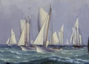
Yachts and yachting in ninteenth-century America were the preserve of the wealthy, and in Lane's early career were just beginning to organize as yacht clubs with scheduled regattas. The New York Yacht Club, founded in 1844, was the first such organization and had few rival clubs for racing or cruising until after the Civil War. (1) In Boston, by contrast, yachts of any size were few. Instead of regattas, competition was in the form of match races, between two vessels, with cash prizes as a substitute for trophies. Often, the only serious competition for a Boston-owned yacht was one of the crack pilot schooners, and it was not uncommon for a yacht to be sold for pilot service or vice-versa. (2)
If Lane had opportunity to portray any yachts in Boston, only his depiction of schooner "Northern Light" (see The Yacht "Northern Light" in Boston Harbor, 1845 (inv. 268)) has been found to date, and that was based on a drawing by Robert Salmon. (3) It seems likely that he would have depicted more Boston yachts, some of which images might still exist in private collections not currently accessible. For more depictions of yachts by Lane, we must look to New York.
Lane is known to have made two paintings of the schooner yacht "America." The more familiar one The Yacht "America" Winning the International Race, 1851 (inv. 255) was based on a lithograph derived from a painting by Oswald Brierly who witnessed and sketched "America" as she raced for the trophy that now bears her name. (4)
The other painting Yacht "America" from Three Views, c.1851 (inv. 395) was very possibly based on sketches of the designer's half-model, or even the actual vessel under construction. In either case, Lane's drawings and any notes would have been made before the hull and deck details were finalized. (5)
It would not be until August 8, 1856 that Lane would see and sketch a major yacht regatta—held by the New York Yacht Club at New Bedford, Massachusetts. From this event, he painted four known views, each depicting a different moment in the race. The earliest New York Yacht Club Regatta (3), After 1856 (inv. 396) shows the yachts under way to the starting line, with the smallest yachts (third class) starting at 10:50 a.m. The second class would start at 10:55 a.m. and the first (largest yachts) at 11:00 a.m. The second view New York Yacht Club Regatta (2), 1856 (inv. 270) shows the start of the first class; the third New York Yacht Club Regatta (4), 1857 (inv. 397), the race after the start with the large sloops and schooners taking the lead. The fourth New York Yacht Club Regatta (1), 1856 (inv. 66), depicting the finish, shows the winning sloop "Julia" over the line, lowering her racing sails, while the rest of the fleet follows her to the finish line. (6 and 7)
As interest in yachting increased, so did leisure pursuits in smaller craft, using rowing and sailing boats for rowing, fishing, and day-sailing. These activities had a commercial side which is covered in the Party Boats descriptive essay, but this essay will deal with boats used for non-commercial recreation.
Hull types and rigs for small pleasure craft were varied, some being traditional work boat designs with a few added amenities for comfort. Others were designed and built for leisure boating, often in the styles of yachts, but smaller and simpler. Among rowing boats, the dory was a logical choice, the version in View of Gloucester, (From Rocky Neck), 1846 (inv. 57) (right foreground) being smaller, with a wider bottom for greater stability. New England boats (see Norman's Woe, Gloucester Harbor, 1862 (inv. 1), View of Gloucester, 1859 (inv. 91), and Castine Harbor and Town, 1851 (inv. 272)) are also to be found in settings more akin to leisure than to work. (8)
Sailing craft custom-built for pleasure were also depicted by Lane. Examples with sloop rigs are found in The Old Fort and Ten Pound Island, Gloucester, 1850s (inv. 30) (left foreground), Fresh Water Cove from Dolliver's Neck, Gloucester, Early 1850s (inv. 45) (center left), and Coming Ashore near Brace's Rock, Gloucester, Massachusetts, c.1860 (inv. 60) (right foreground). The yawl rig is seen in View of Coffin's Beach, 1862 (inv. 41) (right middle ground), and schooners in Fresh Water Cove from Dolliver's Neck, Gloucester, Early 1850s (inv. 45) (right middle ground) and (foreground). These rigs differ only moderately from today's versions; their hull designs remain popular among admirers and owners of "traditional boats."
– Erik Ronnberg
References:
1. William P. Stephens, Traditions and Memories of American Yachting (Camden, ME: International Marine Publishing Co., 1981), 157–59.
2. Ibid., 159–61, 164–66.
3. John Wilmerding, Fitz Hugh Lane, 1804–1865: American Marine Painter (Salem, MA: Essex Institute,1964), 29–30.
4. Erik A.R. Ronnberg, Jr., "Fitz Henry Lane's Yacht America from Three Views: Vessel Portrait or Artist's Concept?," Antiques & Fine Art (Summer/Autumn 2010): 175.
5. Ibid., 174–79.
6. U.S. Nautical Magazine and Naval Journal V (October 1956–March 1857): 16–18.
7. The American Neptune X, no. 3 (July 1950): 231–34. Reprint of an unidentified newspaper account of the 1856 New Bedford Regatta by Robert Bennet Forbes.
8. See the descriptive essay on "New England Boat."
See p. 163.
Also filed under: "Northern Light" (Yacht) »
Parker & Ditson
Courtesy American Antiquarian Society, Worcester, Mass.
Dedicated to the Tiger Boat Club.
Also filed under: Bufford, J. H. Lith. – Boston » // Parker & Ditson, Pub. – Boston » // Sheet Music by other artists » // Thayer's, Lith. – Boston » // Tiger Boat Club »
The Rudder Vol. XV Part 1–3; pp. 387–390, 456–460, 483–486
"Historic American Yachts: Early Boston Vessels, The Northern Light and Coquette."
Also filed under: "Northern Light" (Yacht) »
wood, metal, cordage
Model of schooner yacht "Northern Light" of Boston, 1839
Scale 1:32
Also filed under: "Northern Light" (Yacht) » // Ship Models »
wood, metal, cordage
Model of schooner yacht "Northern Light" of Boston, 1839
Scale 1:32
Also filed under: "Northern Light" (Yacht) »
The ensign of the United States refers to the flag of the United States when used as a maritime flag to indentify nationality. As required on entering port, a vessel would fly her own ensign at the stern, but a conventional token of respect to the host country would be to fly the flag of the host country (the United States in Boston Harbor, for example) at the foremast. See The "Britannia" Entering Boston Harbor, 1848 (inv. 49) for an example of a ship doing this. The American ensign often had the stars in the canton arranged in a circle with one large star in the center; an alternative on merchant ensigns was star-shaped constellation. In times of distress a ship would fly the ensign upside down, as can be seen in Wreck of the Roma, 1846 (inv. 250).
The use of flags on vessels is different from the use of flags on land. The importance and history of the flagpole in Fresh Water Cove in Gloucester is still being studied.
The modern meaning of the flag was forged in December 1860, when Major Robert Anderson moved the U.S. garrison from Fort Moultrie to Fort Sumter in Charleston Harbor. Adam Goodheart argues this was the opening move of the American Civil War, and the flag was used throughout northern states to symbolize American nationalism and rejection of secessionism.
Before that day, the flag had served mostly as a military ensign or a convenient marking of American territory, flown from forts, embassies, and ships, and displayed on special occasions like American Independence day. But in the weeks after Major Anderson's surprising stand, it became something different. Suddenly the Stars and Stripes flew—as it does today, and especially as it did after the September 11 attacks in 2001—from houses, from storefronts, from churches; above the village greens and college quads. For the first time American flags were mass-produced rather than individually stitched and even so, manufacturers could not keep up with demand. As the long winter of 1861 turned into spring, that old flag meant something new. The abstraction of the Union cause was transfigured into a physical thing: strips of cloth that millions of people would fight for, and many thousands die for.
– Adam Goodheart, Prologue of 1861: The Civil War Awakening (2011).
1860s Stereograph card Cape Ann Museum Library & Archive
A view of a Cove on the western side of Gloucester Harbor, with the landing at Brookbank. Houses are seen in the woods back. A boat with two men is in the foreground.
Also filed under: Brookbank » // Fresh Water Cove » // Historic Photographs »
Courtesy American Antiquarian Society, Worcester, Mass. (CL.F9116.011.1854 CL.F9116.011.1854)
Also filed under: Oak Hall »
Courtesy American Antiquarian Society, Worcester, Mass. (CL.F9116.011.1854)
Also filed under: Oak Hall »
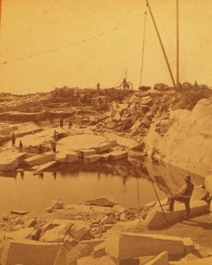
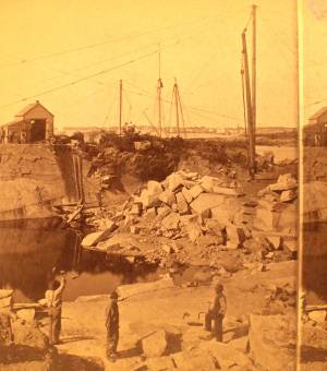
The harvesting of granite from quarries dug deep into the earth was an important industry on Cape Ann from the 1830s through the early 20th century. Second only to fishing in economic output, for 100 years the granite business played a pivotal role in the local economy providing jobs for many, turning profits for some and generating tons and tons of cut granite that was used here on Cape Ann and shipped to ports all along the Atlantic seaboard.
Granite quarrying started slowly in this area in the late eighteenth century with small operations peppered across the rocky terrain. Construction of a fort at Castle Island in Boston Harbor in 1798 followed by a jail in nearby Salem in 1813, jump-started the granite industry here on Cape Ann. During the 1830s and 1840s, the trade grew steadily. By the 1850s, the stone business was firmly established and Cape Ann granite was known throughout the region. So extensive and so awe-inspiring were operations during the second half of the nineteenth century some observers feared that the business might actually run out of stone.
While granite was taken from the earth in all different sizes and shapes, Cape Ann specialized in the conversion of that granite into paving blocks which were used to finish roads and streets. Millions of paving stones were shipped out of Cape Ann annually, destined for construction projects in New York, Philadelphia and all along the Atlantic seaboard. While paving blocks were basically uniform in size, there were subtle differences leading some to be referred to as Philadelphia blocks while others were identified as Boston blocks or Washington blocks.
– Martha Oaks (April, 2015)
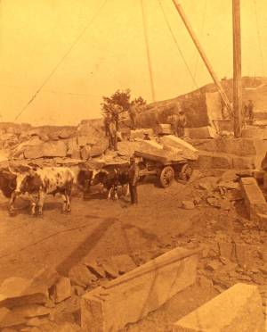
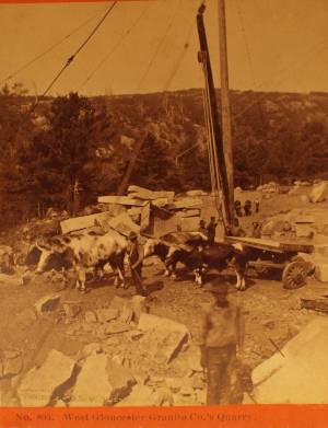
c.1880 Stereograph card Cape Ann Museum Library & Archive
This view shows a wood derrick for hoisting granite blocks.
Also filed under: Eastern Point » // Historic Photographs »
Stereograph
Cape Ann Museum Library & Archive
Also filed under: Historic Photographs »
Stereograph
Cape Ann Museum Library & Archive
Also filed under: Gundalow / Scow »
1851 44 x 34 in. Henry Francis Walling, Map of the Towns of Gloucester and Rockport, Essex Co. Massachusetts. Philadelphia, A. Kollner, 1851 Cape Ann Museum Library & Archive
"Map of the Towns of Gloucester and Rockport, Massachusetts. H.F. Walling, Civil Engineer. John Hanson, Publisher. 1851. Population of Gloucester in 1850 7,805. Population of Rockport in 1850 3,213."
Also filed under: Annisquam River » // Babson House » // Coffin's Beach » // Eastern Railroad » // Gloucester, Mass. – Annisquam Harbor Lighthouse » // Loaf, The » // Low (David) House » // Maps » // Old First Parish / Subsequent Fourth Parish Church (at the Green) » // Riverdale Methodist Church (Washington Street) » // White-Ellery House »
c.1880 Stereograph card Cape Ann Museum Library & Archive
This view shows a wood derrick for hoisting granite blocks.
Also filed under: Eastern Point » // Historic Photographs »
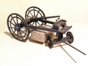
Painted wood
Scale: 1:16. Galamander shop, Vinalhaven, Maine.
Cape Ann Museum. Gift of Barbara Erkkila, 1997
In the nineteenth century granite was hauled from Cape Ann quarries on heavy carts called garymanders which were pulled by oxen or horses (known as "galamander" in Maine.) A boom rigged above the rear axle was used to hoist the stone so it could be held by chains beneath the wagon. The garymander oak wheels were eight feet high with iron rims made by a blacksmith.
Also filed under: Objects »
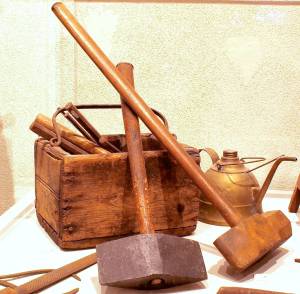
Cape Ann Museum (1994.65)
Oilcan originally owned by Frederickj "Rick" Larsen
Cape Ann Museum (1994.76.3)
Peen hammer originally owned by Johann Jacob Erkkila (1877–1939)
(Cape Ann Museum) 1994.76.23a
Heavy blacksmith's sledge owned by John Fuge (1873–1967)
Cape Ann Museum (1997.24.0)
Although from a later period, these tools are similar to tools used in Lane's time.
Also filed under: Objects »
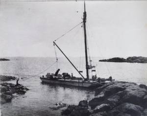
Photograph
Private collection
Granite scow being unloaded at Knowlton's Point, Sandy Bay. Sandy Bay Ledge visible in right background, Dodge's Rock in left background.
Also filed under: Gundalow / Scow »
Wood, metal, cordage, cloth, paint.
Scale: ¼ in. = 1ft. (1:48)
Cape Ann Museum. Gift of Roland and Martta Blanchet (1997.17.3)
Although built in 1890 and larger than the stone sloops of Lane’s time, the "Albert Baldwin’s" hull form, rig, and loading boom are very similar to those of the 1840s and 1850s.
Also filed under: Ship Models » // Sloop »
Stereograph
Cape Ann Museum Library & Archive
Also filed under: Historic Photographs »
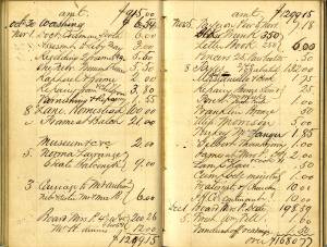
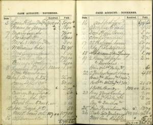
Samuel Elwell Sawyer of Gloucester was a patron of the arts. He visited F. H. Lane’s studio, purchased paintings by him and hired him “to make a sketch of old Homestead for Haughton." (1) Sawyer and Joseph L. Stevens also supported Gloucester artist D. Jerome Elwell in his European studies. We know that in August, 1864, Sawyer ordered two paintings from Lane "to be done [when] he is at leisure," and that he also purchased a painting by Lane for $50 in 1864 at a "Sailors Fare."
Samuel E. Sawyer was born in Gloucester on November 25, 1815 and died at the ancestral homestead in Gloucester on December 15, 1899. He was the fifth generation of Sawyers to occupy Brookbank, an early eighteenth-century gambrel-roofed house located at Freshwater Cove. The Sawyer family history goes back to William Sawyer, who came to New England about 1640.
Samuel's wife was Abigail (Abbie) Ingersoll Meads - they married in Boston on October 30, 1845. They had no children but lived an idyllic life, spending November through March in Boston, and April through October at the family homestead in Gloucester. They spent many years enjoying an accumulated wealth which was generously shared with others. However, life was not always easy for Samuel Sawyer, as he started at the bottom and suffered several financial reversals along the way before becoming financially secure.
Sawyer began his business career as a clerk in Samuel Stevens' dry goods store on Main Street in Gloucester. (2) He soon went to Boston, where he secured a job as a salesman with the firm Kimball and Jewett. He then entered the field of shipping and commerce, and became a partner in the firm of Haughton, Sawyer and Adams. This position took him to all parts of the world, and from it he amassed a fortune as a merchant.
Although a good deal of Sawyer's earlier life was spent in Boston and in travel, nothing could entice him away from the scenes of his childhood. At their Freshwater Cove home, he and Mrs. Sawyer enjoyed their middle age and later years. It was during this period of his life that Samuel Sawyer became one of Gloucester's leading philanthropists. His many gifts and bequests ranged from schoolhouse fences to the present clock in the City Hall tower, and from substantial contributions to the Female Charitable Association to a fund that made it possible to introduce music into the public schools. His most memorable gifts were funds for medals to be given annually to students for scholastic excellence, provision of the building and endowment fund for the Sawyer Free Library, and the land now known as Ravenswood Park.
Mr. Sawyer died from pneumonia at the homestead in Gloucester on December 15, 1889 at the age of seventy-four. Mrs. Sawyer had passed away the preceding year, also from pneumonia.
– Mary Rhinelander McCarl and Stephanie Buck
(1) August 25, 1864 in Samuel Sawyer, Diaries: 1854-1874, trans. Mary Rhinelander McCarl.
(2) Obituary of Joseph L. Stevens, Jr., Gloucester Daily Times, September 21, 1908. Samuel Stevens was Joseph L. Stevens, Jr.’s uncle. When Joseph L. Stevens, Jr. came to Gloucester from Maine in 1840, he first worked in his uncle Samuel’s store.
n.d. Stereographic card Cape Ann Museum Library & Archive
Penciled on reverse: "Mansion House, Brook Bank [sic], Sam'l Sawyer now Hammond, Freshwater Cove"
Also filed under: Brookbank » // Historic Photographs »

1834–35 24 x 38 in. Gloucester City Archives
"Drawn on a scale of one hundred feet to an inch. By John Mason 1834–45 from Actual Survey showing every Lott and building then standing on them giving the actual size of the buildings and width of the streets from the Canal to the head of the Harbour & part of Eastern point as farr as Smith's Cove and the Shore of the same with all the wharfs then in use. Gloucester Harbor 1834–35."
This map is especially helpful in showing the wharves of the inner harbor at the foot of Washington Street.
Typescript
Sawyer Free Library, Gloucester, Mass.
Also filed under: Gloucester Lyceum » // Sawyer Free Library »
Cape Ann Museum Library & Archives
Also filed under: Diaries / Ledgers / Etc. »
Samuel Sawyer Papers
Cape Ann Museum Library & Archives
Archive Collection exp013
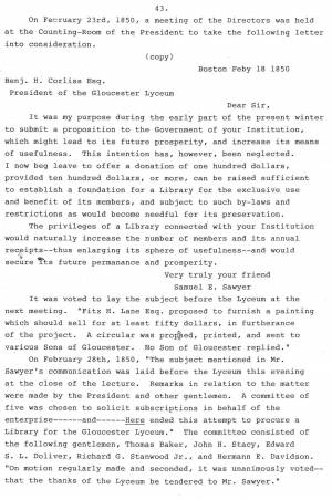
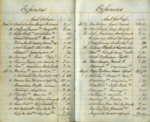
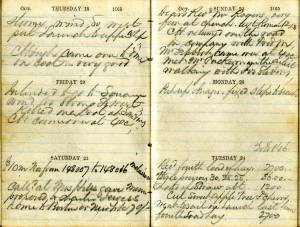
"November 27. Engraving. Arch of Triumph (To James 1/53)
Engraving. Pharaoh’s Horses Painting. Seaview
Traveller & milkmaid. Companions. Hogarth. $2."
Also filed under: Diaries / Ledgers / Etc. » // Lithography (Sales & Exhibitions) »
Samuel Sawyer Papers
Cape Ann Museum Library & Archives
Archive Collection exp014
"November 12. Village Festival
Banck. Sunrise 3.25, Sunset Backhuysen. Sea view, Power of Fashion, Cattle piece. 3 gilt frames"
Also filed under: Diaries / Ledgers / Etc. »
Samuel Sawyer Papers
Cape Ann Museum Library & Archives
Archive Collection exp015
"June 6. 2 Dutch coast scenes & frames. Fremart(?) (One Haughton)"
Also filed under: Diaries / Ledgers / Etc. » // Haughton, James »
Samuel Sawyer Papers
Cape Ann Museum Library & Archives
Archive Collection exp016
"November 8. Lane. Homestead
Frame at Balch
Museum &c. &c."
Also filed under: Balch, William Y. » // Diaries / Ledgers / Etc. »
Samuel Sawyer Papers
Cape Ann Museum Library & Archives
Archive Collection exp017
"June 4. Interior. Peter Neefs
Landscape. Mireveldt Amsterdam. A. Storck
Flower piece. Unknown
Female head. L. Baker
Flowers, bird’s nest.
Schlesinger Flemish peasants. Unknown"
Also filed under: Diaries / Ledgers / Etc. »
Newsprint
From bound volume owned by publisher Francis Procter
Collection of Fred and Stephanie Buck
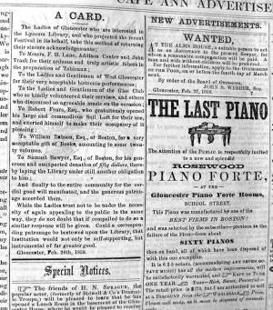
"A CARD. – The Ladies of Gloucester who are interested in the Lyceum Library, and who projected the recent Festival in its behalf, take this method of returning their sincere acknowledgements;
To Messrs. F. H. Lane, Addison Center and John Trask for their arduous and truly artistic labors in the preparation of Tableaux; . . .
To Robert Fears, Esq., who gratuitously opened his large and commodious Sail Loft for their use and exerted himself to make their occupancy of it agreeable;...
To Samuel Sawyer, Esq. of Boston, for his generous and unexpected donation of fifty dollars, thereby laying the Library under still another obligation to him;...
Also filed under: Center, Addison » // Fears, Robert » // Gloucester Lyceum » // Newspaper / Journal Articles » // Trask, John »
Samuel Sawyer Papers
Cape Ann Museum Library & Archives
Archive Collection exp018
"November 12. Winter scene, Scotch boy
Landscape. Griggs Rising by Frost
Chip off the Old Block, Infant Saviour
St. John Dilemma. Rondel
Departure"
Also filed under: Diaries / Ledgers / Etc. »
Samuel Sawyer Papers
Cape Ann Museum Library & Archives
Archive Collection exp020
"Marine View Mt. Desert Light Lane $41.00"
Also filed under: Diaries / Ledgers / Etc. » // Mount Desert, Maine – Mount Desert Rock Light »
Samuel Sawyer Papers
Cape Ann Museum Library & Archives
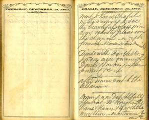
Archive Collection
"After dinner went to the Athanaum[sic]."
Also filed under: Boston – Boston Athenaeum » // Diaries / Ledgers / Etc. »
Samuel Sawyer Papers
Cape Ann Museum Library & Archives
Archive Collection
"February 4. Went to the artists reception this evening. There was a large company. Haven (?) Fields Whipple & Co. We enjoyed the occasion very much. Our invitation came from Mr. Scott, Mr. Bartlett & Lottie also went, Mrs. Haughton did not."
Also filed under: Diaries / Ledgers / Etc. » // Haughton, James » // Scott, John W. A. »
Samuel Sawyer Papers
Cape Ann Museum Library & Archives
Archive Collection
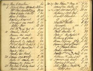
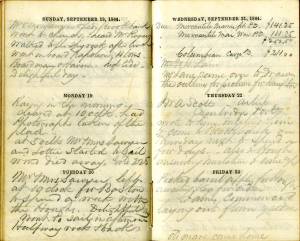
"November 17. Went to Gloucester. Pleasant morning, rainy evening.
Called upon Mr. Lane artist."
Also filed under: Diaries / Ledgers / Etc. »
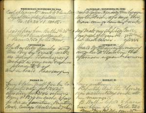
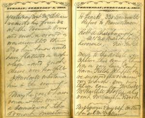
"November 23. Cool & pleasant. Went to Gloucester.
Size of Haughton's pictures 2. 18 x 30 & 1. 10 x 15. [Lane?]"
Also filed under: Diaries / Ledgers / Etc. » // Haughton, James »
Samuel Sawyer Papers
Cape Ann Museum Library & Archives
Archive Collection A#63
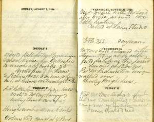
"Got painting. Lane's $50. For Mrs. Cowes. National Sailors Fair."
Also filed under: Boston – 1864 Sailors' Fair » // Cores [Cowes?] Mrs. » // Diaries / Ledgers / Etc. »
Samuel Sawyer Papers
Cape Ann Museum Library & Archives
Archive Collection
"December 2. Went out to call upon J. W. A. Scott East Cambridge artist. He had many sketches. Some of them taken at Gloucester."
Also filed under: Diaries / Ledgers / Etc. » // Scott, John W. A. »
Samuel Sawyer Papers
Cape Ann Museum Library & Archives
Archive Collection
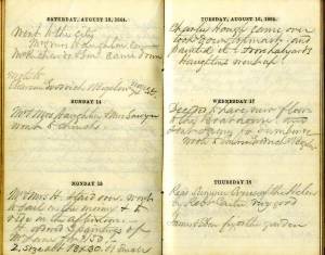
"March 17. Delightful weather.
One of Lane’s Pictures sold at Leonard’s for $55"
Also filed under: Boston – 1864 Joseph Leonard & Co. » // Diaries / Ledgers / Etc. »
Samuel Sawyer Papers
Cape Ann Museum Library & Archives
Archive Collection
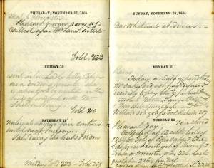
"Rosa Bonheur called" [According to Mary McCarl, this was the name of Sawyer's cow]
Also filed under: Diaries / Ledgers / Etc. »
Samuel Sawyer Papers
Cape Ann Museum Library & Archives
Archive Collection
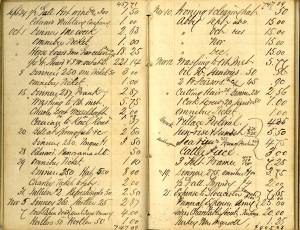
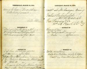
"August 15. Mr. & Mrs. H.(Haughton) staid over, went to sail in the morning & to ride in the afternoon. H. ordered 3 paintings of Mr. Lane for $150, 2 size about 18 x 30, & 1 small."
Also filed under: Diaries / Ledgers / Etc. » // Haughton, James »
Samuel Sawyer Papers
Cape Ann Museum Library & Archives
Archive Collection
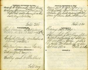
"August 25. Called to see Mr. Lane to make a sketch of old Homestead for Haughtons."
Also filed under: Brookbank » // Diaries / Ledgers / Etc. » // Haughton, James »
Samuel Sawyer Papers
Cape Ann Museum Library & Archives
Archive Collection
"Monday 8th
Ordered from F. H. Lane 2 Pictures 14 x 21 to be done when he is at leisure. One moonlight $25-$30. . .
Tuesday 9th
Called at Lane's studio"
Also filed under: Diaries / Ledgers / Etc. »
Samuel Sawyer Papers
Cape Ann Museum Library & Archives
Archive Collection
"Mr. [F.H. Lane - crossed out] Lane came over to draw the outline for picture for Haughton"
Also filed under: Diaries / Ledgers / Etc. » // Haughton, James »
Samuel Sawyer Papers
Cape Ann Museum Library & Archives
Archive Collection A#63
"Lane Picture Mrs. Cowes $50
Frame for same $18"
Also filed under: Boston – 1864 Sailors' Fair » // Cores [Cowes?] Mrs. » // Diaries / Ledgers / Etc. »
Samuel Sawyer Papers
Cape Ann Museum Library & Archives
Archive Collection
"Met Mr. Tuckerman the artist walking with Jos. Stevens."
Also filed under: Diaries / Ledgers / Etc. » // Stevens, Joseph, Jr. » // Tuckerman, Stephen Salisbury »