An online project under the direction of the CAPE ANN MUSEUM
Catalogue Entry
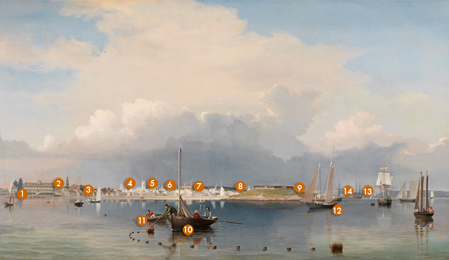
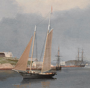
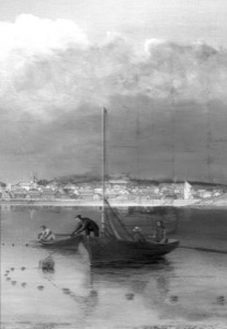
The panoramic scale of this work provides the viewer with a sense of the entire city of Gloucester as it was in 1852: its position in the landscape, its harbor, buildings, and boats, and its people and their endeavors. This is one of several Gloucester city scenes that reveal Lane’s lithography training, showing his skill in depicting city and town views. Another example is the earlier painting Gloucester Harbor from Rocky Neck, 1844 (inv. 14).
Lane succeeds brilliantly here; he has managed to pack the scene with an enormous amount of accurately rendered detail, yet Gloucester Harbor feels spacious and open, dominated by a spectacular sky that floats above a still harbor.
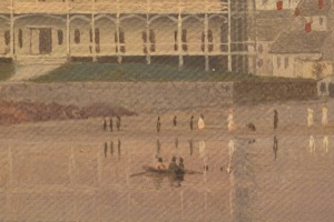
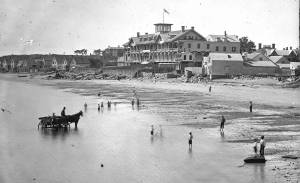
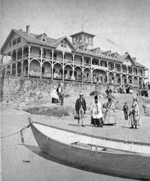
The painting was commissioned by Sidney Mason, a prominent Gloucester businessman who was responsible for much of the new waterfront development within the harbor. He also built the Pavilion Hotel—the large, gabled building on the left end of the beach—which was Gloucester’s first tourist hotel. The hotel opened an important new chapter in the city’s economic and cultural life, and one imagines that Sidney Mason was pleased with this painting, both as a visual testament to his civic pride and as a showcase of all he had worked for.
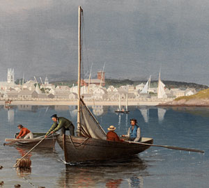
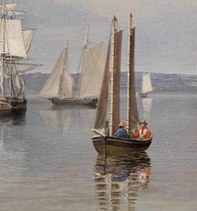
The painting is masterfully composed; Lane has created an effortless order from the complexity of the scene. The eye is led into the harbor by the buoys of the trawl line that arcs to the men in the foreground boat. Behind them, next in the visual trajectory, is the Old Fort, a prominent landmark at the entrance of the Inner Harbor. The Old Fort was a remnant of the 1700s and the Revolutionary War and appears at one end of the beach as a symbol of the old Gloucester. At the other end, Pavilion Hotel represents the new Gloucester. The vessels are also a mix of old and new; small pleasure craft, new to Gloucester, are comingled with the working boats.
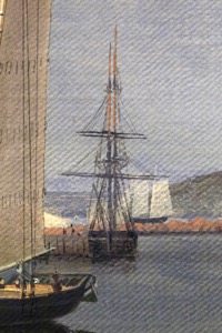
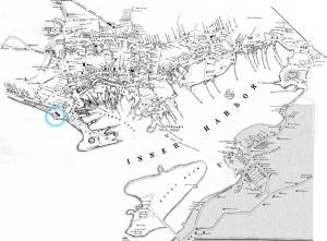
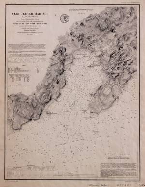
The enlargements of the painting below show the extraordinary detail Lane took from his watercolor sketch for this work (Gloucester from the Outer Harbor, 1852 (inv. 72)). The sketch, so scrupulously accurate that one can identify all the buildings and churches—many them still standing today (see Interactive Feature)—was done from a boat at the point in the harbor shown on the map below. It was unusual for Lane to use watercolor as he did in this depiction of the Old Fort.
Note the horseman on the beach and the tourists bathing in front of the hotel. Behind the buildings at the right end of the beach, we can see masts and sails looming up from their anchorages in Harbor Cove, the busiest waterfront area within Gloucester's Inner Harbor at the time. The Fort area was not yet surrounded with wharves and houses, but along the narrow, sandy neck connecting the mainland to the rocky height, one can see the fishing industry warehouses. Lane did not depict the flake yards—where split cod was laid out to dry—as they appear in the 1851 Walling map. The large, white warehouse of George H. Rogers hovers behind the earthworks. The windmill that had once stood on the site of the Pavilion, though here out of sight to the viewer, was tucked behind this warehouse.
Also noticeable are the great variety of vessels that used Gloucester Harbor. Recent conservation infrared images have revealed that originally Lane planned to have a large topsail schooner just to the left of the Fort. Instead he painted over it, and even lowered the sail on the small ship in its place, probably so that the skyline of Gloucester would be more clearly visible.
Lane has imbued this work with a grandeur that belies its fairly ordinary subject matter. There are no heroic activities here, no battles or great pronouncements, yet one is stirred by the promise of the shining white city, the clouds arching overhead, the calm order of the vessels suspended in their reflections. Gloucester here appears as polis, the Greek ideal of the city-state, one that benefits all its citizens. The term was applied to Gloucester by the poet Charles Olson a hundred years after this picture was painted, but it is an apt description of the optimism and idealistic vision of America in the early 1850s.
– Sam Holdsworth
- Subject Types
: - Vessel Types
: - Cape Ann Locales
: - Animals & People
: - Activities of People
: - Objects
: - Barrel »
- Building Types
:
Historical Materials

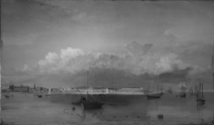
1852 Oil on canvas 28 x 48 1/2 in. Cape Ann Museum, Gloucester, Mass., Deposited by the City of Gloucester, Given to the city by Mrs. Julian James in memory of her grandfather Sidney Mason, 1952 (DEP. 200)
Detail of Lane's signature. The image has been color enhanced for legibility.
Filed under: Signature / Name change »
1852
Oil on canvas
28 x 48 1/2 in.
Cape Ann Museum, Gloucester, Mass., Deposited by the City of Gloucester, 1952. Given to the city by Mrs. Julian James in memory of her grandfather Sidney Mason, 1913 (DEP. 200)
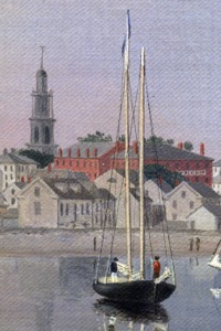
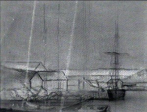
Detail of fishing schooner.
Filed under: Gloucester Harbor, Inner / Harbor Cove » // Schooner (Fishing) »
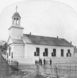
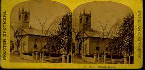
The old Baptist church appears in several Lane works. This was the first of three Baptist churches built on Pleasant Street. Baptists had been meeting on Cape Ann since 1808, originally in Sandy Bay (Rockport). But in 1830, a small group of Gloucester Baptists raised the funds to build a simple, unornamented, steeple-less white wooden building and chose this site near Franklin Square. Lane lithographs and paintings document the history of the building. In 1836, he showed it without a steeple. The building was improved in 1837 with the addition of a choir and the steeple, as seen in Lane's 1844 painting.
The building was not a church at the time of the painting of Gloucester Harbor in 1852, where it can be seen between the square four-spiked steeple of the First Parish Church and the mast of the closest, central boat. The Baptists, having recently built the large Italianate church seen just to the right in that 1852 painting, had sold the old Baptist church to Benjamin S. Corliss and other neighbors in 1850. Then in 1855, the Catholic community of Gloucester bought and moved the old church building around the corner to Prospect Street. The first Catholic mass had been held in 1849, in a private home, although the town hall was also available for masses. By 1855, the Catholic community established St. Ann's Parish, first in the old Baptist building (once again without a steeple, probably lost during the move from Pleasant Street), and then, when the current large stone church was built in 1876, this building became a school. It was replaced by the still-standing brick St. Ann's Parochial School in 1913.
– Sarah Dunlap (August, 2013)
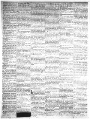
Newspaper clipping
Cape Ann Advertiser
Collection of Fred and Stephanie Buck
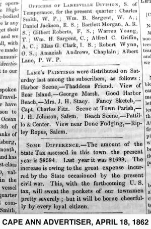
"LANE'S PAINTINGS were distributed on Saturday last among the subscribers, as follows: Harbor Scene, – Thaddeus Friend. View of Bear Island, – George Marsh. Good Harbor Beach, – Mrs. J. H. Stacy. Fancy Sketch, – Capt. Charles Fitz. Scene at Town Parish, – J. H. Johnson, Salem. Beach Scene, – Pattillo & Center. View near Done Fudging, – Ripley Ropes, Salem."
Also filed under: Alex Patillo Dry Goods » // Center & Co. » // Center, Henry » // Done Fudging » // Fitz, Capt. Charles » // Friend, Thaddeus » // Johnson, J. H. » // Marsh, George » // Newspaper / Journal Articles » // Patillo, Alex » // Ropes, Ripley » // Stacy, Mr. and Mrs. John Hancock »

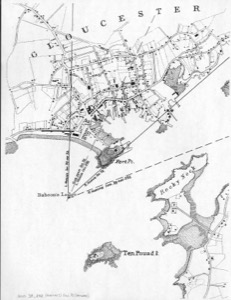
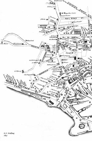
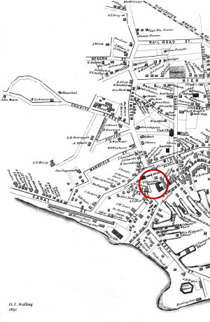
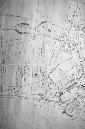
1851 44 x 34 in. Henry Francis Walling, Map of the Towns of Gloucester and Rockport, Essex Co. Massachusetts. Philadelphia, A. Kollner, 1851 Cape Ann Museum Library & Archive
"Map of the Towns of Gloucester and Rockport, Massachusetts. H.F. Walling, Civil Engineer. John Hanson, Printer. 1851. Population of Gloucester in 1850 7,805. Population of Rockport in 1850 3,213."
Also filed under: Burnham Brothers Marine Railway » // Duncan's Point » // Five Pound Island » // Flake Yard » // Gloucester Harbor, Inner / Harbor Cove » // Harbor Methodist Church (Prospect Street) » // Low (Frederick G.) wharves » // Pavilion Hotel » // Procter Brothers » // Ropewalk » // Vincent's Cove » // Western Shore »
Although in his 1852 Gloucester Harbor, Lane painted the Second Baptist Church to look like Italian brick, this building was in fact clad in New England clapboard, of an unknown but perhaps reddish color. It was the second Baptist church built in Gloucester, the first being just up Pleasant Street and visible in the same painting as the white steeple to the left. The second Baptist Church was designed by Gridley J.F. Bryant of Boston (the same architect who twenty years later would design Gloucester's City Hall) and was dedicated the year before, in March 1851. The minister at the time of the 1852 painting was Miles Sanford.
The church replaced a tavern on land directly across the street from Lane's childhood home. Lane never painted his old house, sold out of the family in 1839, but its location is often near the center of canvases of the harbor. In Gloucester Harbor, 1852 (inv. 38) painting at CAM, it was in the cluster of wooden houses partially covering the wall of the second Baptist church, to the right of the ship's mast. It was here that the young Nathaniel Rogers Lane played, ate the legendary and hypothetical "apple of Peru" to cause his lameness, learned the shoemaker's trade, and drew his early sketches of boats and sails. The site of the Lane house is now occupied by the old Gloucester Cooperative Bank building at 85 Middle Street.
This Baptist Church burned in December 1869, and was replaced in 1871 by the third Baptist church to stand on Pleasant Street, which in turn was torn down in 1966 to create a parking lot. But the large granite block used as its front step now forms the bottom of the pathway from the parking lot on Rogers Street up to the stone Fitz Henry Lane house.
Current address: Parking lot on Pleasant Street between Middle and Warren Streets, opposite the Cape Ann Museum.
– Sarah Dunlap (August, 2013)
44 x 34 in.
Henry Francis Walling, Map of the Towns of Gloucester and Rockport, Essex Co. Massachusetts. Philadelphia, A. Kollner, 1851
Cape Ann Museum Library & Archive
"Map of the Towns of Gloucester and Rockport, Massachusetts. H.F. Walling, Civil Engineer. John Hanson, Publisher. 1851. Population of Gloucester in 1850 7,805. Population of Rockport in 1850 3,213."
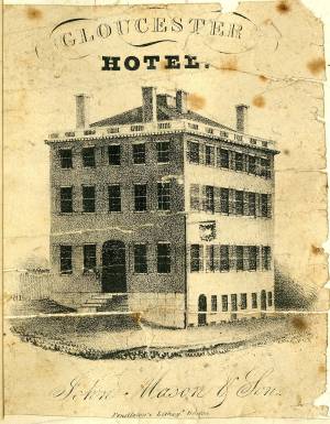
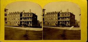
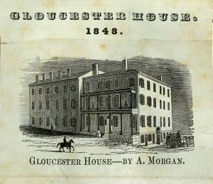
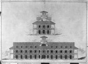
The Brick Houses were a cluster of buildings and a center of commerce and residence for wealthy local merchants. The brick hotel, the Gloucester House, was built by Col. James Tappan in 1810. It was four stories high, and scoffers of his grandiose hopes called it Tappan's Folly. It was from this hotel that stage coaches, before the 1847 extension of railroad to Gloucester, left for Boston every morning at 7:00 and returned every afternoon at 4:00. The hotel was opened year round, and was used by tourists and business people, as well as by local organizations. The John Mason family owned the hotel since the 1820s, and John's son Sidney Mason was the proprietor. Lane had perhaps already made an advertisement lithograph of this hotel in 1836. Sidney Mason also built the elaborate and luxurious summer Pavilion Hotel directly on the beach of the Outer Harbor. Both hotels are prominent in Gloucester Harbor, 1852 (inv. 38), and perhaps therefore the reason why Sidney commissioned Lane to paint that view. Col. Abijah Peabody, "one of the best landlords in the country," managed both hotels in 1852. Through the years, this brick hotel has also been named the Atlantic House, the Mason House, the Puritan House, and Blackburn Tavern. It still stands, offering a basement restaurant and upstairs public rooms.
The Gloucester House was the only brick building in the West End of town at the time of the disastrous fire on September 16, 1830, that wiped out blocks of wooden buildings and wharves. The brick buildings to the south and east of the Gloucester House replaced houses destroyed by that fire. Fire was an ever-present fear to Lane, who limped and walked with some difficulty. The story of the burning at sea of a merchant vessel on May 26, 1830, caught his attention, and the young artist, still Nathaniel Rogers Lane, painted Burning of the Packet Ship "Boston", 1830 (inv. 82) soon thereafter. A few months later, Lane, 26, lame and still living at home, experienced the panic and destruction of the September fire. His family's house on Middle Street was in danger, but survived intact. In 1849, after Lane returned to Gloucester from his lithography years in Boston, he built a fire-resistant stone house on Duncan's Point.
These brick houses were inhabited by wealthy merchants, owners of the wharves and businesses, next to the Town Landing and the intersection of Washington and Front Streets. Among them were Samuel Gilbert, James Mansfield, and Cyrus and Zachariah Stevens. Zachariah Stevens was the grandfather of Lane's friend and future executor, Joseph L. Stevens, Jr. Joseph lived with Zachariah from 1840 until his grandfather's death in 1846. Although still in Boston during this time, Lane frequently returned to his family and friends in Gloucester, and the two probably often met in the grandfather's house. Joseph and Lane made frequent trips to Joseph's parents' home in Castine, Maine.
Current address: West End of Main Street.
– Sarah Dunlap (August, 2013)
Cape Ann Museum Library & Archive
Stereo view
Also filed under: Historic Photographs »
Newsprint
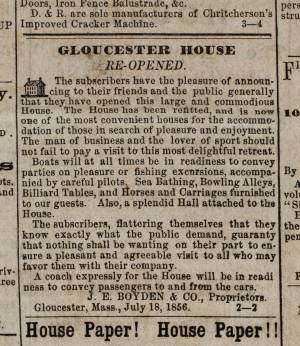
Ad for Gloucester House
Courtesy of the American Antiquarian Society, Worcester, Mass.
See p. 4, column 2.
Also filed under: Newspaper / Journal Articles » // Party Boat »
High Street is the old name for the west end of what is now Prospect Street. Originally, it was Back Street, to go with Middle and Front Streets. Front Street became Main Street. Middle Street is still Middle Street. Back Street became High Street, and then adopted the name Prospect Street which already had gone from Pleasant Street east.
– Sarah Dunlap
Glass plate negative from Benham Collection
Cape Ann Museum Library & Archive
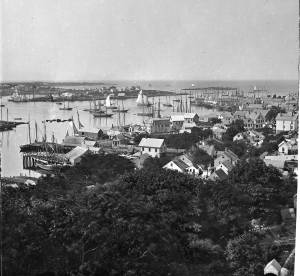
View of Gloucester Harbor from Friend Street Wharves, Five Pound Island segment at far left, Rocky Neck, Eastern Point and Ten Pound Island in background.
Also filed under: Eastern Point » // Five Pound Island »
44 x 34 in.
Henry Francis Walling, Map of the Towns of Gloucester and Rockport, Essex Co. Massachusetts. Philadelphia, A. Kollner, 1851
Cape Ann Museum Library & Archive
"Map of the Towns of Gloucester and Rockport, Massachusetts. H.F. Walling, Civil Engineer. John Hanson, Publisher. 1851. Population of Gloucester in 1850 7,805. Population of Rockport in 1850 3,213."
Also filed under: Gloucester Bank » // Low, Capt. Frederick Gilman » // Maps » // Stacy, Eben Hough »
Stereograph card Cape Ann Museum Library & Archive
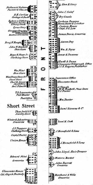
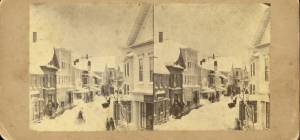
Looking east down Main Street after storm of April 5, 1861; Centre Street enters from the left at "Job Printing" and John C. Calef, dry goods shop is on the right. (Buck and Dunlap, p. 97).
Also filed under: Historic Photographs » // J. C. Calef Dry Goods »
Original print not available; image from copy negative in collection of the Cape Ann Museum.
Also filed under: Historic Photographs »
44 x 34 in.
Henry Francis Walling, Map of the Towns of Gloucester and Rockport, Essex Co. Massachusetts. Philadelphia, A. Kollner, 1851
Cape Ann Museum Library & Archive
"Map of the Towns of Gloucester and Rockport, Massachusetts. H.F. Walling, Civil Engineer. John Hanson, Publisher. 1851. Population of Gloucester in 1850 7,805. Population of Rockport in 1850 3,213."
Also filed under: Maps » // Procter Brothers »
Oil on canvas
15 x 24 in.
Cape Ann Museum, Gloucester, Mass., Gift of Harold and Betty Bell, 1980 (2211)
Also filed under: Elwell, D. Jerome » // Town House »
Stereograph card Cape Ann Museum Library & Archive
Also filed under: Historic Photographs »
possibly 1884 Stereograph card Cape Ann Museum Library & Archive
Also filed under: Historic Photographs » // Sawyer Free Library »
Stereograph card Cape Ann Museum Library & Archive
Also filed under: Gloucester Harbor, Inner / Harbor Cove » // Historic Photographs »
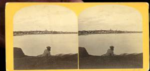
c.1870s Stereograph card Cape Ann Museum Library & Archive
From East Gloucester looking towards Gloucester.
Also filed under: Gloucester Harbor, Inner / Harbor Cove » // Historic Photographs »
c.1870 Stereograph card Cape Ann Museum Library & Archive
Also filed under: Half Moon Beach » // Historic Photographs » // Stage Rocks / Stage Fort / Stage Head » // Steepbank »
c.1870 Stereograph card Cape Ann Museum Library & Archive
Also filed under: Historic Photographs » // Stage Rocks / Stage Fort / Stage Head »
Stereograph card Cape Ann Museum Library & Archive
1775–1875 Gloucester's Centennial, August 9th. Stereoscopic views of the celebration.
Also filed under: Historic Photographs »
c.1890 Stereograph card Cape Ann Museum Library & Archive
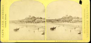
"In the foreground is a clear sheet of water which washes upon the beach beyond. The Pavilion is quite prominent, while upon the rising background can be seen the steeples of the several churchs, the tower of the first Town House, and the Collins School House."
Also filed under: Historic Photographs » // Pavilion Hotel » // Stage Rocks / Stage Fort / Stage Head »
c.1880 Stereograph card Cape Ann Museum Library & Archive
"Bond's Hill is a high eminence on the west side of Gloucester Harbor. The foreground is very rocky and shows a portion of the old road to West Gloucester and Essex, used before the road was built across the marsh, which is to be seen in the center of the picture. Beyond the marsh road is the canal with its dyke. Then the ground rises and dwelling houses appear, till Lookout Hill (or Mount Vernon Street.) can be seen on the left of the background. On the right of the picture is the 'Cut' road, the only carriage entrance into the main part of the town. Beyond it is to be seen 'Crescent Beach,' with the Pavilion and 'old Fort' and a portion of East Gloucester in the background. In the centre of the picture can be seen the unfinished tower of the Town House, and in the distance is the open sea, with Thatcher's Island and its lighthouses just discernible."
Also filed under: Historic Photographs » // Pavilion Hotel »
Cape Ann Museum Library & Archive
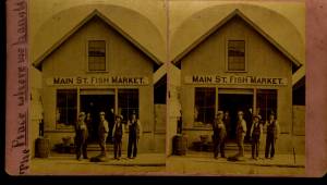
View shows Main Street Fish Market, Gloucester, Mass.
Also filed under: Fishing » // Historic Photographs »
In 1828, the Methodists built the Harbor Methodist Church towards the eastern end of Prospect Street. This was also called the "Church on the Rock," for they followed Matthew's advice and planted it firmly on a granite outcropping. Lane's mother, the widow Sarah Haskell Lane, and his brother Edward Lane were members in high standing of this congregation. In fact, Edward was on its Board of Trustees and served as a steward and a "class leader." Even after the Riverdale Methodist Meetinghouse was built in 1838, on Washington Street overlooking Mill River, and even after the Lanes had sold their house on Middle Street and moved to the old Whittemore house near Oak Grove Cemetery, Edward Lane and his mother continued to be members of the Harbor Methodist Society. Lane’s mother died in 1853, but when Lane painted the 1852 Gloucester Harbor, she and her son were still active members. The ministers in 1851 and 1852 were Rev. Jarvis Wilson and Rev. Linus Fish; there were about 115 members. This building was used as the Harbor's Methodist meetinghouse until 1858, when the society bought and moved into another meetinghouse on Elm Street and sold this building to George H. Rogers for $300.
It is probable that the church is the Prospect Street Church mentioned in a petition to the Selectmen of Gloucester in January 1859, by citizens who wished that the Town would buy and convert it into a schoolhouse. The building was still standing in 1876 but no longer exists.
Methodism began in Europe in 1738, came to New York City in 1760, and to Gloucester in 1806. The first meetings in town were in the house of John Edney on the eastern edge of the Mill Pond in the Town Parish (now Riverdale). In 1823, Rev. George Pickering arrived in town and meetings were held in the old first parish meetinghouse at the Green, near the White-Ellery House.
Current address: Southeast corner of Prospect and Taylor Streets.
– Sarah Dunlap (August, 2013)
1851 44 x 34 in. Henry Francis Walling, Map of the Towns of Gloucester and Rockport, Essex Co. Massachusetts. Philadelphia, A. Kollner, 1851 Cape Ann Museum Library & Archive
"Map of the Towns of Gloucester and Rockport, Massachusetts. H.F. Walling, Civil Engineer. John Hanson, Printer. 1851. Population of Gloucester in 1850 7,805. Population of Rockport in 1850 3,213."
Also filed under: Baptist Church (Old, First, 1830) (Pleasant Street) » // Burnham Brothers Marine Railway » // Duncan's Point » // Five Pound Island » // Flake Yard » // Gloucester Harbor, Inner / Harbor Cove » // Low (Frederick G.) wharves » // Pavilion Hotel » // Procter Brothers » // Ropewalk » // Vincent's Cove » // Western Shore »
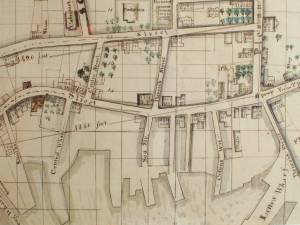
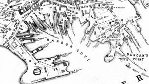
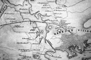
In the 1850s, Captain Frederick G. Low owned fully one-third of the land comprising Duncan's point, including the lot purchased by Lane for his home and studio. Much of his property fronted the Inner Harbor, including two wharves in Harbor Cove and a third jutting southeast from the point toward Harbor Rock (see Walling & Hanson map below.)
Low's wharves are not conspicuous in any of Lane's depictions of Gloucester Harbor, which is ironic because many of his harbor scenes were sketched from Low's property. In The Fort and Ten Pound Island, Gloucester (Harbor Scene), 1848 (inv. 58), his wharf adjacent to the Collins estate wharf is obscured by a building on the Collins wharf and a ship tied up to his own wharf. In Gloucester Harbor, 1852 (inv. 38), his wharf extending to Harbor Rock is concealed by the rocks off Fort Point with only a bark to mark the head of the wharf to which it is tied up.
Gloucester Harbor from Rocky Neck, 1844 (inv. 14), depicting the town from Rocky Neck, is the only painting which shows the shore line where Lowe's wharves were located (or to be located, given the early, 1844, date of this work). Lane's lithograph of 1846 (View of Gloucester, (From Rocky Neck), 1846 (inv. 57)) is similarly problematic, and his 1859 version () shows so many changes that the earlier wharves are no longer discernible.
– Erik Ronnberg
Watercolor on paper
Cape Ann Museum Library & Archive
Also filed under: Maps » // Unitarian Church / First Parish Church (Middle Street) »
1851 44 x 34 in. Henry Francis Walling, Map of the Towns of Gloucester and Rockport, Essex Co. Massachusetts. Philadelphia, A. Kollner, 1851 Cape Ann Museum Library & Archive
"Map of the Towns of Gloucester and Rockport, Massachusetts. H.F. Walling, Civil Engineer. John Hanson, Printer. 1851. Population of Gloucester in 1850 7,805. Population of Rockport in 1850 3,213."
Also filed under: Baptist Church (Old, First, 1830) (Pleasant Street) » // Burnham Brothers Marine Railway » // Duncan's Point » // Five Pound Island » // Flake Yard » // Gloucester Harbor, Inner / Harbor Cove » // Harbor Methodist Church (Prospect Street) » // Pavilion Hotel » // Procter Brothers » // Ropewalk » // Vincent's Cove » // Western Shore »

1834–35 Lithograph 24 x 38 in. Gloucester City Archives
"Drawn on a scale of one hundred feet to an inch. By John Mason 1834–45 from Actual Survey showing every Lott and building then standing on them giving the actual size of the buildings and width of the streets from the Canal to the head of the Harbour & part of Eastern point as farr as Smith's Cove and the Shore of the same with all the wharfs then in use. Gloucester Harbor 1834–35."
This map shows the location of F. E. Low's wharf and the ropewalk. Duncan's Point, the site where Lane would eventually build his studio, is also marked.
The later notes on the map are believed to be by Mason.
Also filed under: Duncan's Point » // Gloucester Harbor, Inner / Harbor Cove » // Low, Capt. Frederick Gilman » // Maps » // Mason, John » // Residences » // Ropewalk » // Somes, Capt. John »
44 x 34 in.
Henry Francis Walling, Map of the Towns of Gloucester and Rockport, Essex Co. Massachusetts. Philadelphia, A. Kollner, 1851
Cape Ann Museum Library & Archive
"Map of the Towns of Gloucester and Rockport, Massachusetts. H.F. Walling, Civil Engineer. John Hanson, Publisher. 1851. Population of Gloucester in 1850 7,805. Population of Rockport in 1850 3,213."
Segment of Harbor Village portion of map showing Low's, Rogers', and other wharves in the Inner Harbor.
Also filed under: Rogers's (George H.) wharves »
44 x 34 in.
Henry Francis Walling, Map of the Towns of Gloucester and Rockport, Essex Co. Massachusetts. Philadelphia, A. Kollner, 1851
Cape Ann Museum Library & Archive
"Map of the Towns of Gloucester and Rockport, Massachusetts. H.F. Walling, Civil Engineer. John Hanson, Publisher. 1851. Population of Gloucester in 1850 7,805. Population of Rockport in 1850 3,213."

44 x 34 in.
John Hanson, Publisher
Cape Ann Museum Library & Archive
"Map of the Towns of Gloucester and Rockport, Massachusetts. H.F. Walling, Civil Engineer. John Hanson, Publisher. 1851. Population of Gloucester in 1850 7,805. Population of Rockport in 1850 3,213."
Also filed under: Fort (The) and Fort Point » // Maps » // Rogers's (George H.) wharves » // Town / Public Landings » // Waterfront, Gloucester » // Windmill »
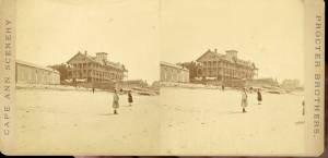
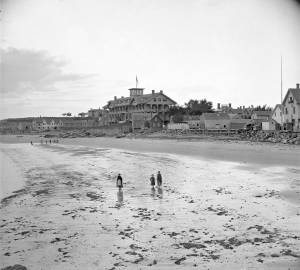
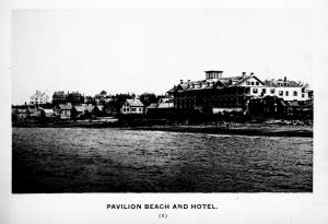
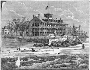
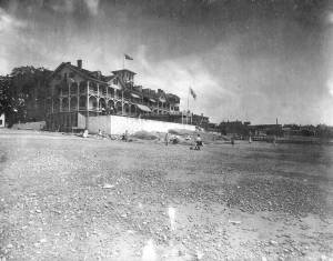
The Pavilion, built in 1849 for Sidney Mason, was Gloucester's first summer resort hotel. Mason was a patron of Lane, and he commissioned him to paint three views of scenes of his mercantile successes: New York Harbor, San Juan [Saint John] Harbor, and Gloucester Harbor, 1852 (inv. 38), in which the hotel, with all its porches, towers and tracery, is a prominent feature. Mason himself helped the architect S. Charles Bugbee design the building, that was then constructed by White and Winchester. A grist windmill, originally owned by Ignatius Webber and then by Sidney Mason's father, John Mason, had stood on the hill since 1814, but, in preparation for the Pavilion Hotel, was moved to the inner-harbor side of the old Fort and eventually burned in 1877. Both the windmill and the Fort can be seen in several Lane harbor paintings and drawings.
Sidney Mason lived in New York City at this time but was closely connected to his home town of Gloucester and owned another, traveler's hotel, the Gloucester House. But the Pavilion brought in an entirely new and different type of visitor to the fishing and trading town of Gloucester. The railroad from Boston had reached Salem in 1839 and Gloucester in November 1847. This not only led to Lane's return to Gloucester after his fifteen year residence in Boston, it also facilitated an influx of summer people. Before this time, a combination of stagecoaches, ferries, steamers and trains was needed to make the trip. Now, the wealthy from New York and Philadelphia could travel easily to Gloucester, as well as to other North Shore communities.
The hotel was not isolated from the business of the town. Next door to the west was one of the several long ropewalks in town. It was built by Ignatius Webber in 1803 and produced many of the miles of hemp rope and twine needed in the maritime trading and fishing trades. To the east, along the beach, were flake yards, where acres of split cod and other fish were laid out to dry in the sun. Lane did not include these in his painting. Nor is there any sign of tension between the tourist hotel and the local inhabitants and industries.
The Pavilion Hotel offered spectacular views and walks, both coastal and inland, and bathing was available all along the public beach that stretched to the Fort. The hotel itself was advertised as elegant, with luxurious sitting rooms, gas lighting and modern conveniences. Its first years were not entirely successful under the management of Dr. H.T. Haughey, once manager of Delaware's Brandywine Springs. But in 1852, Col. Abijah Peabody, manager of Mason's other hotel, the Gloucester House, took over the Pavilion and it flourished.
The Pavilion Hotel grounds were used during the Civil War as a recruiting office. It became the Surfside Hotel, and burned on Saturday, October 17, 1914. It was soon replaced by the Tavern, and that building still exists although no longer as a hotel and without the elegance and architectural flare of the original Pavilion.
Current address: 28–30 Western Avenue, The Tavern.
– Sarah Dunlap (September, 2013)
Stereograph card
Cape Ann Museum Library & Archive
Pavilion Hotel and the beach looking west from the Fort, Beach Court and Western Avenue.
Also filed under: Pavilion (Publick) Beach »
1834–35 Lithograph 24 x 38 in. Gloucester City Archives
"Drawn on a scale of one hundred feet to an inch. By John Mason 1834–45 from Actual Survey showing every Lott and building then standing on them giving the actual size of the buildings and width of the streets from the Canal to the head of the Harbour & part of Eastern point as farr as Smith's Cove and the Shore of the same with all the wharfs then in use. Gloucester Harbor 1834–1835."
This section of the map shows the location of the Pavilion Hotel and ropewalk along the beach.
Also filed under: Maps » // Mason, John » // Pavilion (Publick) Beach » // Ropewalk » // Windmill »
1851 44 x 34 in. Henry Francis Walling, Map of the Towns of Gloucester and Rockport, Essex Co. Massachusetts. Philadelphia, A. Kollner, 1851 Cape Ann Museum Library & Archive
"Map of the Towns of Gloucester and Rockport, Massachusetts. H.F. Walling, Civil Engineer. John Hanson, Printer. 1851. Population of Gloucester in 1850 7,805. Population of Rockport in 1850 3,213."
Also filed under: Baptist Church (Old, First, 1830) (Pleasant Street) » // Burnham Brothers Marine Railway » // Duncan's Point » // Five Pound Island » // Flake Yard » // Gloucester Harbor, Inner / Harbor Cove » // Harbor Methodist Church (Prospect Street) » // Low (Frederick G.) wharves » // Procter Brothers » // Ropewalk » // Vincent's Cove » // Western Shore »
Newspaper
Gloucester Telegraph p. 2 col. 2
Boston Public Library
Accession # G587
"Charlotte Cushman leaves for Europe today in steamship Asia, from New York,– She takes with her two of Lane's finest marine paintings, which she purchased on Monday."
Also filed under: Cushman, Charlotte » // Newspaper / Journal Articles »
1854 Newspaper "Letters on Art. - No. IV"
"In that space [four years] the town has grown greatly . . . a great ugly, yellow "Pavilion" suns itself on the rocks . . . I said there are only two stone buildings in this town of Gloucester: one is "the Bank," the other belongs to Mr. F. H. Lane, whose name ought to be known from Maine to Georgia as the best marine painter in the country.
If Mr. Lane is not as well known as he ought to be, he has at least no reason to complain of neglect or want of appreciation. He has been painting only fifteen years, and his pictures are in great demand; hitherto chiefly among sea-faring men, but now winning way in other circles. In former times I used to be often in Mr. Lane's painting-room, and it was with real pleasure that I found my way to his new house, built from his own design, of native granite, as I mentioned, handsome, peculiar, stable, and commanding a wide sweep of land and ocean from its ample windows. The house is the best that has been built in Gloucester for fifty years. . .
Mr. Lane has put few pictures in his studio at present; for he is very industrious, and sends his canvases off as fast as they are filled. If you were to meet him in the street, you would hardly take him for an artist. A man apparently of forty years, walking with difficulty, supported by crutches, hard-handed, browned by the sun and exposure, with a nose indicating less the artist sensibility than the artist resolution . . .
His early pictures had something in them too hard and practical to permit enthusiastic admiration; the water was salt, the ships sailed, the waves moved, but it was the sea before the Spirit of God moved upon the face of the deep.
His pictures early delighted sailors by their perfect truth. Lane knows the name and place of every rope on a vessel; he knows the construction, the anatomy, the expression – and to a seaman every thing that sails has expression and individuality . . . [Lane] has earned his money thus far mostly by painting "portraits" of vessels for sailors and ship-owners. It is owing to this necessity, perhaps, that he has fallen into the fault of too great literalness of treatment, which I have mentioned as characterizing some of his earlier works; but with the rapid advance he has made in the past four years, there is no longer any fear that he is incapable of treating a subject with genuine imagination . . .
He has indulged in no tricks and no vagaries; he has slighted nothing, despised nothing. If I appear to think less of his early pictures than they deserve, it is not because they are carefully even painfully studied, and because no detail has escaped his eye or brush; it is not that he has too much conscience; but simply because I missed in them the creative imagination of the artist. But it may well be a question whether at this day, when slight and untruthful work prevails, when artists will not paint with conscience, and the public does not strenuously demand it, conscience and love are not higher needs than imagination, and whether Mr. Lane's early pictures, the landmarks on his toilsome, earnest journey to his present place, have not a great value of their own. There is not one of them that I have seen, without some valuable passage, showing acute observation and careful, studious execution.
A sea-piece, "Off the coast of Maine, with Desert-Island in the distance," is the finest picture that Mr. Lane has yet painted. The time is sunset after a storm. The dun and purple clouds roll away to the south-west, the sun sinks in a glory of yellow light, flooding the sea with transparent splendor. Far away in the offing, hiding the sun, sails a brig fully rigged . . . I urged Mr. Lane to send this picture to New-York for exhibition . . ."
Also filed under: Newspaper / Journal Articles » // Residences »
Newsprint
Gloucester Telegraph
Cape Ann Museum Library & Archive
At a Sanitary Fair held at the Pavilion "obtained through the favor and generosity of the owner, Mr. SIDNEY MASON, of New York, and to whom many thanks are due." "... hangs a fine picture, the generous gift of our own Artist, Mr. Lane. The Subject is "Coffin's Beach," as seen from the "Loaf." This is the most costly article on sale in the rooms, and is valued at $100. It will be disposed of by tickets $1 each."
Two paintings by Lane, Little Good Harbor Beach and View from the Loaf were on sale at the Fair.
c.1870s Stereograph card Cape Ann Museum Library & Archive
Stereo view of the Pavilion from the southern or sea side.
Also filed under: Historic Photographs » // Pavilion (Publick) Beach »
Stereograph card Hervey Friend, Gloucester, Mass., Publisher Cape Ann Museum Library & Archive
Stereo view of the Pavilion Hotel from the street side.
Also filed under: Historic Photographs »
c.1890 Stereograph card Cape Ann Museum Library & Archive
"In the foreground is a clear sheet of water which washes upon the beach beyond. The Pavilion is quite prominent, while upon the rising background can be seen the steeples of the several churchs, the tower of the first Town House, and the Collins School House."
Also filed under: Gloucester – City Views » // Historic Photographs » // Stage Rocks / Stage Fort / Stage Head »
c.1880 Stereograph card Cape Ann Museum Library & Archive
"Bond's Hill is a high eminence on the west side of Gloucester Harbor. The foreground is very rocky and shows a portion of the old road to West Gloucester and Essex, used before the road was built across the marsh, which is to be seen in the center of the picture. Beyond the marsh road is the canal with its dyke. Then the ground rises and dwelling houses appear, till Lookout Hill (or Mount Vernon Street.) can be seen on the left of the background. On the right of the picture is the 'Cut' road, the only carriage entrance into the main part of the town. Beyond it is to be seen 'Crescent Beach,' with the Pavilion and 'old Fort' and a portion of East Gloucester in the background. In the centre of the picture can be seen the unfinished tower of the Town House, and in the distance is the open sea, with Thatcher's Island and its lighthouses just discernible."
Also filed under: Gloucester – City Views » // Historic Photographs »
c.1870s Stereograph card Cape Ann Museum Library & Archive
Also filed under: Historic Photographs » // Pavilion (Publick) Beach »
c.1870s Stereograph card Cape Ann Museum Library & Archive
Also filed under: Historic Photographs » // Pavilion (Publick) Beach »
c.1870 Cape Ann Museum Library & Archive
Taken from Fort Point looking west. Ropewalk just to west of hotel.
Also filed under: Historic Photographs » // Pavilion (Publick) Beach » // Ropewalk »
c.1900.
Also filed under: Pavilion (Publick) Beach »
George H. Rogers was one of Gloucester's most enterprising citizens of the mid-nineteenth century. In the early 1830s, he ventured into the Surinam trade with great success, leading him to acquire a wharf at the foot of Sea Street. Due to Harbor Cove's shallow bottom at low tide, berthings at wharves had to be done at high tide, leaving the ships grounded at other times. Many deep-loaded vessels had to anchor outside Harbor cove and be partially off-loaded by "lighters" (shallow-draft vessels that could transfer cargo to the wharves) before final unloading at wharfside. To lessen this problem, Rogers had an unattached extension built out from his wharf into deeper water (see The Fort and Ten Pound Island, Gloucester (Harbor Scene), 1848 (inv. 58), right middle ground). The space between the old wharf and the extension may have been a way to evade harbor regulations limiting how far a pier head could extend into the harbor. Stricter rules were not long in coming after this happened!
About 1848, Rogers acquired land on the east end of Fort Point, first putting up a large three-story building adjacent to Fort Defiance, then a very large wharf jutting out into Harbor Cove. Lane's depictions of Harbor Cove and Fort Point show progress of this construction in 1848 (The Fort and Ten Pound Island, Gloucester (Harbor Scene), 1848 (inv. 58)), 1850 (Gloucester Inner Harbor, 1850 (inv. 240)), and c.1851 (Gloucester Harbor at Dusk, c.1852 (inv. 563)). A corner of the new wharf under construction can also be seen more closely in Ten Pound Island, Gloucester, 1850s (inv. 17) and Ten Pound Island in Gloucester Harbor, 1864 (inv. 104) (foregrounds). This new wharf provided better frontage for large ships to load and unload, as well as larger warehouses and lofts for storage of goods and vessel gear.
By 1860, Rogers was unloading his Surinam cargos at Boston, as ever-larger ships and barks were more easily berthed there. His Gloucester wharves continued to be used for deliveries of trade goods by smaller vessels. In the late 1860s, Rogers' wharf at Fort Point (called "Fort Wharf" in Gloucester directories) was acquired by (Charles D.) Pettingill & (Nehemiah) Cunningham for use in "the fisheries" as listed by the directory. in 1876, it was sold to (John J.) Stanwood & Company, also for use in "the fisheries." (1)
Lowe's Wharf, adjacent to Fort Wharf, was acquired by (Sylvester) Cunningham & (William) Thompson, c.1877 and used in "the fisheries" as well. That wharf and its buildings were enlarged considerably as the business grew. By this time, Harbor Cove was completely occupied by businesses in the fisheries or providing services and equipment to the fishing fleet. In photographs of Fort Point from this period, it is difficult to distinguish one business from another, so closely are they adjoined.
– Erik Ronnberg
Reference:
1. A city atlas, dated 1899, indicates that Rogers's wharf at Fort Point was still listed as part of his estate. If so, then Stanwood & Co. would have been leasing that facility from the Rogers's estate.
44 x 34 in.
Henry Francis Walling, Map of the Towns of Gloucester and Rockport, Essex Co. Massachusetts. Philadelphia, A. Kollner, 1851
Cape Ann Museum Library & Archive
"Map of the Towns of Gloucester and Rockport, Massachusetts. H.F. Walling, Civil Engineer. John Hanson, Publisher. 1851. Population of Gloucester in 1850 7,805. Population of Rockport in 1850 3,213."
Segment of Harbor Village portion of map showing Low's, Rogers', and other wharves in the Inner Harbor.
Also filed under: Low (Frederick G.) wharves »
44 x 34 in.
Henry Francis Walling, Map of the Towns of Gloucester and Rockport, Essex Co. Massachusetts. Philadelphia, A. Kollner, 1851
Cape Ann Museum Library & Archive
"Map of the Towns of Gloucester and Rockport, Massachusetts. H.F. Walling, Civil Engineer. John Hanson, Publisher. 1851. Population of Gloucester in 1850 7,805. Population of Rockport in 1850 3,213."
44 x 34 in.
John Hanson, Publisher
Cape Ann Museum Library & Archive
"Map of the Towns of Gloucester and Rockport, Massachusetts. H.F. Walling, Civil Engineer. John Hanson, Publisher. 1851. Population of Gloucester in 1850 7,805. Population of Rockport in 1850 3,213."
Also filed under: Fort (The) and Fort Point » // Low (Frederick G.) wharves » // Maps » // Town / Public Landings » // Waterfront, Gloucester » // Windmill »

1865 41 x 29 inches Courtesy of the Massachusetts Archives Maps and Plans, Third Series Maps, v.66:p.1, no. 2352, SC1/series 50X
.
Also filed under: Burnham Brothers Marine Railway » // Collins's, William (estate wharf) » // Gloucester Harbor, Inner / Harbor Cove » // Maps »

1876 Photograph Cape Ann Museum Library & Archive
Ignatius Weber's windmill (now defunct) is shown.
Also filed under: Flake Yard » // Fort (The) and Fort Point » // Gloucester Harbor, Inner / Harbor Cove » // Historic Photographs » // Schooner (Fishing) » // Waterfront, Gloucester » // Windmill »
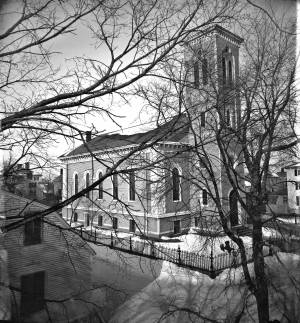
The Trinity Congregational Church, visible in Lane paintings such as Gloucester Harbor, 1852 (inv. 38), was built in 1831, during the time of the reconstruction of downtown Gloucester after the devastating 1830 fire. But this church was not built to replace one lost in that conflagration. It was built to house a large faction of the original First Parish Church (the four -pointed square tower visible in several paintings, just to the east on Middle Street) that was dismayed by the Unitarian drift of the parish. The rise of Unitarianism, and the hiring of new ministers with that leaning, caused those who continued to embrace the older Puritan, Calvinist, Congregational beliefs to secede and form their own church. It was a split between the more radical, newer element of the Unitarians and those who wished to maintain their older, Trinitarian roots.
The minister of the Trinitarian church in 1852 was James Aiken, who did not stay in town long. Nor did the building serve long as a church. In 1854, the building was sold, cut in half, and moved. Both halves now stand on Mason Street, facing south, across School Street from the Central Fire Station.
A second Trinity Congregational Church, with a steeple higher than any other in town, was immediately erected on same site in 1854. This 153-foot, octagonal steeple, visible in Gloucester from Steepbank, c.1855 (inv. 125) was removed in 1865. The church building was totally destroyed by fire in July 1979. A third church stands on the site today.
Current address: 70 Middle Street at the corner of School Street. However, the building that appears in pre-1854 Lane works was cut in half and moved to 2–8 Mason Street.
– Sarah Dunlap (August, 2013)
On Middle St., the building of the new Orthodox Church will soon be commenced. …we understand that the church when completed, will be the finest in the country. It is to be surmounted by a steeple higher than any other in town, and will be a prominent land mark. The contractors, Messrs. Smith & Babson, are young and enterprising mechanics, and will spare no pains to render the completion of the edifice as perfect and handsome as can be accomplished. The old church having been cut in two, and moved back on Mason Street, is being fitted up, and will be made into two large double dwelling houses. Another building has also been moved into this street and is being fitted up for a dwelling house.
The First Parish (Unitarian) meeting house, located on Middle Street, was a wooden framed, clapboard-sheathed structure with a distinctive four-pointed neo-Gothic inspired tower. It was built in 1828, as the First Parish Church, replacing an earlier structure built on the site in 1738, when the "first" parish moved to the Harbor from its original location on the Annisquam River near where the Rte. 128 Grant Circle now is laid out. The parish system dated from the Massachusetts Bay Colony times, when both religious and civic business was conducted in the parish meetinghouses. This 1828 building was a descendant of that system. It became the Unitarian Church gradually in the 1830s, when more traditional members separated, formed their own society and built the Congregational/Trinitarian Church two doors to the west on Middle Street. The Universalists, Methodists, and Baptists had already seceded and formed their own congregations, and the parish system was at an end.
The Unitarian William Mountford, newly arrived from England, preached in this church from 1850 to 1853. In 1852, a new organ was dedicated on July 4, and Rev. Mountford was installed formally on August 3. (1) It is not known if Lane himself was a member of this or any church, but he shared several traits with Mountford: they both walked with a limp, and they were both interested in Spiritualism. Mountford moved to Boston in 1853 to pursue Transcendentalism and Spiritualism, and seldom returned to Gloucester. But he did come back in August, 1865, to officiate at Fitz Henry Lane's funeral, although Rev. Robert P. Rogers was minister at the time. It was from this church that Lane's body made its final journey to the Oak Grove Cemetery, where he was buried in the family plot of Joseph L. Stevens, Jr.
This building remained the Unitarian Church through the 1940s; however, the congregation had dwindled significantly and was no longer able to maintain the structure. The Gothic steeple was removed during this time. By 1950, the few remaining congregants were meeting with the Universalists further along Middle Street and the assets of the church were divided up: the church silver, made by Paul Revere, went to the Cape Ann Museum; endowment funds went to the Unitarian headquarters in Boston and the meeting house was sold to the local Jewish community who transformed it into Temple Ahavat Achim. Another victim of fire, it was destroyed in the conflagration that began in the next-door Lorraine Apartments on a wintry night of December, 2007.
Current Address: 86 Middle Street, site of Temple Ahavat Achim.
– Sarah Dunlap
Reference:
1. Babson, History of Gloucester, p. 497.
Watercolor on paper
Cape Ann Museum Library & Archive
Also filed under: Low (Frederick G.) wharves » // Maps »
c.1868 Glass plate negative
Also filed under: Lane's Stone House, Duncan's Point » // Residences »
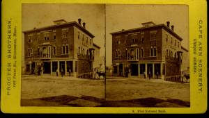
Stereograph card Cape Ann Museum Library & Archive
Also filed under: Historic Photographs » // Procter Brothers »
44 x 34 in.
Henry Francis Walling, Map of the Towns of Gloucester and Rockport, Essex Co. Massachusetts. Philadelphia, A. Kollner, 1851
Cape Ann Museum Library & Archive
"Map of the Towns of Gloucester and Rockport, Massachusetts. H.F. Walling, Civil Engineer. John Hanson, Publisher. 1851. Population of Gloucester in 1850 7,805. Population of Rockport in 1850 3,213."
See p. 498. This shows the First Parish Meeting House before it was rebuilt in 1828.
Also filed under: Babson History of the Town of Gloucester »

Stereograph card
Cape Ann Museum Library & Archive
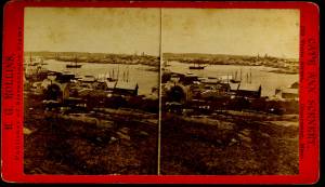
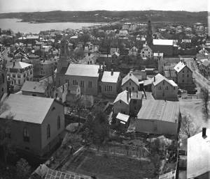
View from top of Unitarian Church on Middle Street looking southeast, showing the Fort and Ten Pound Island. Tappan Block and Main Street buildings between Center and Hancock in foreground.
Also filed under: Fort (The) and Fort Point » // Ten Pound Island »
Cape Ann Museum Library & Archive
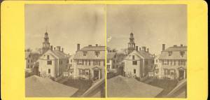
Middle Street looking west. At the corner of Dale Avenue is the Sanders-Davidson house, later Sawyer Free Library. Also shown: Unitarian Church, Congregational Church.
Also filed under: Sanders-Davidson House »
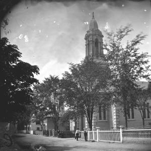
This large steepled building is Gloucester's Universalist Church. Universalism had found fertile ground here in Gloucester before the Revolution under the leadership of John Murray, who brought the teachings of James Relly from England in 1774. With adherents among the town's leaders such as Winthrop Sargent and his daughter, Judith Sargent Stevens Murray, it spread and flourished. The Gloucester adherents to Universalism refused to support quasi-governmental parish churches, specifically the First Parish in the Harbor district, and, speaking as well for all other non-parish churches, their dissent led to the Constitutional separation of Church and State. The first Universalist meetings were held on Sargent property at what was then Spring and Water Streets, now near the corner of Main and Duncan Streets. In 1805, under a new minister, Thomas Jones, this towering structure of the Universalist Church was erected by the local architect and builder, Jacob Smith.
The church's interior and foundation have been changed slightly since Lane's 1852 painting: in the 1860s, the foundation was raised seven feet to allow for a hall in the basement, and the lovely curved vestry staircases were installed. But the steeple remains as Smith, and Lane, saw it. It still houses a Paul Revere bell—for many years the only large bell in town. In 1852, this was the tallest structure on the skyline and a beacon to returning vessels. Its height was increased by the addition of a 'blind story' to the stack of belfry, lantern and cupola.
In 1852, the minister of the church was Amory D. Mayo, but in three years William R.G. Mellen would occupy the pulpit. He and his brother Charles Mellen were both Universalist ministers. Charles' wife was Mary Blood Mellen, Lane's student and copyist, but Charles was never a minister in Gloucester.
Current address: 50 Middle Street.
– Sarah Dunlap (May, 2014)
Cape Ann Museum Library & Archive
Stereo view of a front and side view of the Church, taken when there was no foliage upon the trees. Church street is also given throughout its length.
Also filed under: Historic Photographs »
1865 Stereograph card Cape Ann Museum Library & Archive
Also filed under: Historic Photographs »
44 x 34 in.
Henry Francis Walling, Map of the Towns of Gloucester and Rockport, Essex Co. Massachusetts. Philadelphia, A. Kollner, 1851
Cape Ann Museum Library & Archive
"Map of the Towns of Gloucester and Rockport, Massachusetts. H.F. Walling, Civil Engineer. John Hanson, Publisher. 1851. Population of Gloucester in 1850 7,805. Population of Rockport in 1850 3,213."

1834–35 24 x 38 in. Gloucester City Archives
"Drawn on a scale of one hundred feet to an inch. By John Mason 1834–45 from Actual Survey showing every Lott and building then standing on them giving the actual size of the buildings and width of the streets from the Canal to the head of the Harbour & part of Eastern point as farr as Smith's Cove and the Shore of the same with all the wharfs then in use. Gloucester Harbor 1834–35."
This map is especially helpful in showing the wharves of the inner harbor at the foot of Washington Street.
Also filed under: Dale, Eben B. » // Eastern Railroad » // Flake Yard » // Gloucester Harbor, Inner / Harbor Cove » // Hough, Benjamin Kent » // Maps » // Pavilion (Publick) Beach » // Ropewalk » // Sawyer, Samuel » // Town / Public Landings »

4 x 6 in.
Cape Ann Museum, Benham Collection
George Steele sail loft, William Jones spar yard, visible across harbor. Photograph is taken from high point on the Fort, overlooking business buildings on the Harbor Cove side.
Also filed under: Fort (The) and Fort Point » // Gloucester Harbor, Inner / Harbor Cove » // Town House » // Waterfront, Gloucester »
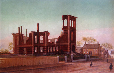
Through the years, this point and its fortifications had many names: Watch House Point, the Old Battery, Fort Defiance, Fort Head, and now just "The Fort." In 1793, Fort Defiance was turned over to the young United States government and was allowed to deteriorate. During the War of 1812 it was described as being "in ruins," and any remaining buildings burned in 1833. It was resuscitated in the Civil War and two batteries of guns were installed. The City of Gloucester did not regain ownership of the land until 1925.
The first fortifications on this point, guarding the entrance to the Inner Harbor, were put up in the 1740s, when fear of attack from the French led to the construction of a battery armed with twelve-pounder guns. Greater breastworks were thrown up in 1775, after Capt. Lindsay and his sloop-of-war the "Falcon" attacked the unprepared town. They were small and housed only a few cannon and local soldiers. Several other fortifications were at various times erected around the harbor: Fort Conant at what is now Stage Fort Park, another on Duncan's Point (near site of Lane's house) and the Civil War fort on Eastern Point. None of these preparations was ever called upon to actually defend the town.
Lane during his lifetime created a long series of images of the point and the condition of its fortifications. In 1832 there were still buildings standing, and the point had not yet been used for major wharves and warehouses. By the time of his painting Gloucester Harbor, 1852 (inv. 38), one can see that the earthwork foundation, but no superstructures, survived.
– Sarah Dunlap

1860 In John J. Babson, History of the Town Gloucester (Gloucester, MA: Procter Brothers, 1860) Cape Ann Museum Library & Archives, Gloucester, Mass.
See p. 474.
View related catalogue entries (4) »
Also filed under: Babson History of the Town of Gloucester » // Chebacco Boat / Dogbody / Pinky » // Gloucester Harbor, Inner / Harbor Cove » // Gloucester, Mass. - "Ten Pound Island Light » // Schooner (Coasting / Lumber / Topsail / Packet / Marsh Hay) » // Ten Pound Island »
Newsprint
Gloucester Telegraph
About picture of Old Fort hanging in the Gloucester Bank: "This picture is chiefly of interest on account of its preserving so accurately the features of a view so familiar to many of our citizens and which can never exist in reality."
Also filed under: Chronology » // Gloucester Bank » // Gloucester, Mass. – Gloucester Bank » // Newspaper / Journal Articles »

24 x 38 in.
Gloucester City Archives
"Drawn on a scale of one hundred feet to an inch. By John Mason 1834–45 from Actual Survey showing every Lott and building then standing on them giving the actual size of the buildings and width of the streets from the Canal to the head of the Harbour & part of Eastern point as farr as Smith's Cove and the Shore of the same with all the wharfs then in use. Gloucester Harbor 1834–35."
This map is especially useful in showing the Fort.
Also filed under: Flake Yard » // Maps » // Mason, John » // Pavilion (Publick) Beach » // Town / Public Landings »
44 x 34 in.
John Hanson, Publisher
Cape Ann Museum Library & Archive
"Map of the Towns of Gloucester and Rockport, Massachusetts. H.F. Walling, Civil Engineer. John Hanson, Publisher. 1851. Population of Gloucester in 1850 7,805. Population of Rockport in 1850 3,213."
Also filed under: Low (Frederick G.) wharves » // Maps » // Rogers's (George H.) wharves » // Town / Public Landings » // Waterfront, Gloucester » // Windmill »
Newsprint
Cape Ann Advertiser
Cape Ann Museum Library & Archive
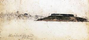
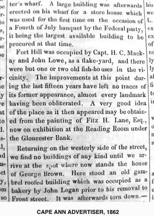
"Fort Hill was occupied by Capt. H. C. Mackay and John Lowe, as a flake-yard, and there were but one or two old fish-houses in the vicinity. The improvements at this point during the last fifteen years have left no traces of its former appearance, almost every landmark having been obliterated. A very good idea of the place as it then appeared may be obtained from the painting of Fitz H. Lane, Esq., now on exhibition at the Reading Room under the Gloucester Bank."
Also filed under: Gloucester Bank » // Newspaper / Journal Articles »
Newspaper
Gloucester Telegraph
"By the will of the late Fitz H. Lane, Esq., his handsome painting of the Old Fort, Ten Pound Island, etc., now on exhibition at the rooms of the Gloucester Maritime Insurance Co., was given to the town... It will occupy its present position until the town has a suitable place to receive it."
Also filed under: Funeral & Burial » // Gloucester, Mass. – Marine Insurance Company » // Newspaper / Journal Articles » // Ten Pound Island »
Newsprint
Gloucester Telegraph
At the dedication of the Town House, speaker, "read the following letter:
To the Selectmen of Gloucester: / Gents: The will of our late Townsman, Fitz. H. Lane, contains this provision: / I give to the inhabitants of the Town of Gloucester, the picture of the Old Fort, to be kept as a memento[sic] of one of the localities of olden time; the said picture now hanging in the Reading Room under the Gloucester Bank, and to be there kept until the Town of Gloucester shall furnish a suitable and safe place to hang it. / The original sketch was taken twenty-five years ago, but the boats and vessels introduced are those of a quarter of a century earlier still. The painting was executed in 1859, six years before his decease."
Also filed under: Documents / Objects » // Newspaper / Journal Articles » // Town House »
Stereograph card
Cape Ann Museum Library & Archive
View from top of Unitarian Church on Middle Street looking southeast, showing the Fort and Ten Pound Island. Tappan Block and Main Street buildings between Center and Hancock in foreground.
Also filed under: Ten Pound Island » // Unitarian Church / First Parish Church (Middle Street) »
1876 Photograph Cape Ann Museum Library & Archive
Ignatius Weber's windmill (now defunct) is shown.
Also filed under: Flake Yard » // Gloucester Harbor, Inner / Harbor Cove » // Historic Photographs » // Rogers's (George H.) wharves » // Schooner (Fishing) » // Waterfront, Gloucester » // Windmill »
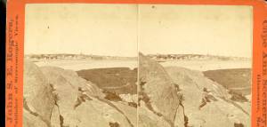
Gloucester Outer Harbor served as a staging area for deep draft or heavily laden vessels waiting to come into the wharves in the shallow Old Harbor at high tide, or waiting to discharge cargo into smaller vessels. While Lane's paintings typically show one or two vessels in the harbor, works by other artists from the period, as well as contemporary descriptions, demonstrate that the harbor was usually crowded with vessels, especially in bad weather. The Outer Harbor could accommodate as many as three hundred vessels when they needed to shelter during a storm.
There were two deep spots where they could wait, the "Deep Hole" between Ten Pound Island and the Fort; and the "Pancake Grounds" between Ten Pound Island and Eastern Point. The "Pancake Grounds" also served as a quarantine area for ships arriving from foreign ports. "Deep Hole" was named for the (relatively) deep water between Rocky Neck and Fort Point to the Outer Harbor. Deeply loaded vessels had to anchor there for “lightering” (partial unloading by boats called “lighters”) prior to final unloading at wharfside. "Deep Hole" was 20–25 feet deep at low tide, when Harbor Cove was only 1–6 feet deep with bare ground around some wharves. "Deep Hole" is where you see ships anchored in Gloucester Harbor from Rocky Neck, 1844 (inv. 14), The Old Fort and Ten Pound Island, Gloucester, 1850s (inv. 30), , Gloucester Inner Harbor, 1850 (inv. 240), The Fort and Ten Pound Island, Gloucester, Massachusetts, 1847 (inv. 271), and Gloucester Harbor, 1848 (inv. 335) (which is coming to anchor).
The term "Deep Hole" is apparently a post-Bellum term. Prior to that, it was known as "The Stream" and, as later, served as anchorage where deeply loaded vessels could be lightered prior to docking in Harbor Cove. Alfred Mansfield Brooks in his book Gloucester Recollected uses this term on page 53. After the Civil War, merchant shipping in Gloucester was dominated by salt ships and later coal carriers, bringing a whole new culture to the harbor, and with it new names for old places.

John Heywood Photo for Hervey Friend
Cape Ann Museum Library & Archive (2013.068)
Schooners anchored on the Pancake Ground, taken from from Wonson's Cove, easterly side of the Rocky Neck causeway. Eastern Point Fort and garrison in background to far left.
Also filed under: Eastern Point »

c.1870 Stereograph card Procter Brothers, Publisher Cape Ann Museum Library & Archive
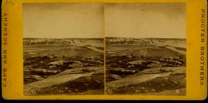
"Gloucester Harbor from Rocky Neck, Looking Southwest. This gives a portion of the Harbor lying between Ten Pound Island and Eastern Point. At the time of taking this picture the wind was from the northeast, and a large fleet of fishing and other vessels were in the harbor. In the range of the picture about one hundred vessels were at anchor. In the small Cove in the foreground quite a number of dories are moored. Eastern Point appears on the left in the background."
Southeast Harbor was known for being a safe harbor.
Also filed under: Historic Photographs » // Rocky Neck » // Schooner (Fishing) » // Small Craft – Wherries, and Dories »

Collection of Erik Ronnberg
View related catalogue entries (2) »
Also filed under: Dolliver's Neck » // Fresh Water Cove » // Gloucester Harbor, Inner / Harbor Cove » // Maps »

c.1870 Stereograph card Procter Brothers, Publisher Cape Ann Museum Library & Archive
View from Civil War fort on Eastern Point.
Also filed under: Eastern Point » // Historic Photographs »


44 x 34 in.
Henry Francis Walling, Map of the Towns of Gloucester and Rockport, Essex Co. Massachusetts. Philadelphia, A. Kollner, 1851
Cape Ann Museum Library & Archive
"Map of the Towns of Gloucester and Rockport, Massachusetts. H.F. Walling, Civil Engineer. John Hanson, Publisher. 1851. Population of Gloucester in 1850: 7,805. Population of Rockport in 1850: 3,213."
Also filed under: Annisquam River » // Brookbank » // Dolliver's Neck » // Fresh Water Cove » // Maps » // Norman's Woe » // Stage Rocks / Stage Fort / Stage Head » // Steepbank » // West Gloucester – Little River » // Western Shore »
Newsprint
Cape Ann Advertiser
Cape Ann Museum Library & Archive
Notice in the Cape Ann Advertiser announcing arrival of ships into the port of Gloucester, with details of their cargo.
Also filed under: Newspaper / Journal Articles » // Trade Routes and Statistics »
Newspaper
"Lane's studio seldom presents so many attractions to visitors as at the present time. With unwonted rapidity his easel has turned off pictures in answer to the numerous orders which have poured in from all quarters."
Also filed under: Chronology » // Newspaper / Journal Articles » // Studio Descriptions »
Electrotype impression
Collection of Erik Ronnberg
Also filed under: Gloucester Harbor, Inner / Harbor Cove » // Maps »

c.1870 Stereograph card Procter Brothers, Publisher Cape Ann Museum Library & Archive
Also filed under: Historic Photographs » // Stage Rocks / Stage Fort / Stage Head »

Pencil and ink on paper
15 x 22 1/8 in.
Cape Ann Museum, Gloucester, Mass., Gift of Mr. Donald K. Usher, in memory of Mrs. Margaret Campbell Usher, 1984 (2401.19)
Also filed under: Beacons / Monuments / Spindles » // Mackerel Fishing »

Watercolor on paper
8 3/4 x 19 3/4 in.
Cape Ann Museum, Gloucester, Mass., Gift of Rev. and Mrs. A. A. Madsen, 1950
Accession # 1468
Fishing schooners in Gloucester's outer harbor, probably riding out bad weather.
Also filed under: Elwell, D. Jerome » // Schooner (Fishing) »
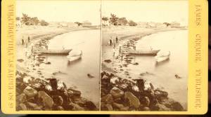
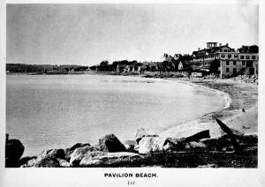
Pavilion Beach is an approximately 1/5 mile long sandy beach that runs along the south side of Commercial Street from Fort Square to the public landing at the easterly end of Western Avenue. The beach faces out over Gloucester Harbor.
Pavilion Beach has long played an important role in the history of Gloucester’s Harbor Village. During Colonial times, the sandy beach was recognized as a crucial barrier between the potentially turbulent waters of Gloucester’s Outer Harbor and the tranquility of Harbor Cove, an inlet which offered a safe area for the construction of wharves and the berthing of vessels. So important was the barrier that during the 1720s town officials awarded a handful of respected merchants a land grant encompassing 80 feet of uplands with the proviso that they promptly build a wharf and maintain it in order to prevent the sea from washing over. During the 1730s, as maritime based commerce slowly took hold around Gloucester Harbor, additional grants were made designed to increase investment in the land and encourage its responsible use. Historian John J. Babson noted that at that same time (c.1730) a group of citizens was enlisted to form a committee… to repair the beach, that the sea might not break over it ‘& spoyl the harbour…” In 1742, funds were appropriated by the General Court of the Commonwealth for the construction of a fortification at the seaward end of Pavilion Beach. The citizens of Gloucester had been asking for protection from possible attacks by sea since the early 1700s. Once commitments were made to the project, the preservation of Pavilion Beach became even more crucial.
For many of Fitz Henry Lane’s generation, here on Cape Ann and afar, Pavilion Beach was synonymous with sightings of the famous Gloucester sea serpent. Reports of a serpent frolicking in Gloucester Harbor were first made in August 1817. So credible were the reports that testimony was formally gathered under oath by the New England Linnaean Society and published in a small tract. The serpent returned in subsequent years generating a flood of publicity which helped jump start Cape Ann’s early summer tourist business in the decades leading up to the Civil War.
– Martha Oaks (April, 2015)
Stereograph card
Cape Ann Museum Library & Archive
Pavilion Hotel and the beach looking west from the Fort, Beach Court and Western Avenue.
Also filed under: Pavilion Hotel »
24 x 38 in.
Gloucester City Archives
"Drawn on a scale of one hundred feet to an inch. By John Mason 1834–45 from Actual Survey showing every Lott and building then standing on them giving the actual size of the buildings and width of the streets from the Canal to the head of the Harbour & part of Eastern point as farr as Smith's Cove and the Shore of the same with all the wharfs then in use. Gloucester Harbor 1834–35."
This map is especially useful in showing the Fort.
Also filed under: Flake Yard » // Fort (The) and Fort Point » // Maps » // Mason, John » // Town / Public Landings »
c.1870s Stereograph card Cape Ann Museum Library & Archive
Also filed under: Historic Photographs » // Pavilion Hotel »
1834–35 Lithograph 24 x 38 in. Gloucester City Archives
"Drawn on a scale of one hundred feet to an inch. By John Mason 1834–45 from Actual Survey showing every Lott and building then standing on them giving the actual size of the buildings and width of the streets from the Canal to the head of the Harbour & part of Eastern point as farr as Smith's Cove and the Shore of the same with all the wharfs then in use. Gloucester Harbor 1834–1835."
This section of the map shows the location of the Pavilion Hotel and ropewalk along the beach.
Also filed under: Maps » // Mason, John » // Pavilion Hotel » // Ropewalk » // Windmill »
1834–35 24 x 38 in. Gloucester City Archives
"Drawn on a scale of one hundred feet to an inch. By John Mason 1834–45 from Actual Survey showing every Lott and building then standing on them giving the actual size of the buildings and width of the streets from the Canal to the head of the Harbour & part of Eastern point as farr as Smith's Cove and the Shore of the same with all the wharfs then in use. Gloucester Harbor 1834–35."
This map is especially helpful in showing the wharves of the inner harbor at the foot of Washington Street.
Also filed under: Dale, Eben B. » // Eastern Railroad » // Flake Yard » // Gloucester Harbor, Inner / Harbor Cove » // Hough, Benjamin Kent » // Maps » // Ropewalk » // Sawyer, Samuel » // Town / Public Landings » // Universalist Church (Middle and Church Streets) »
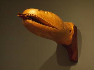
Carved wood with paint and gilt
12 x 22 x 8 in.
Cape Ann Museum. Gift of George W. Woodbury, 1936 (747)
This sea serpent billet head came from the schooner "Diadem" which was built in Essex, Massachusetts, in 1855 and owned by D. Elwell Woodbury and John H. Welsh of Gloucester.
Sea serpents were reportedly sighted here on Cape Ann from colonial times through the mid-nineteenth century. In 1817, more than 50 people, many of them prominent members of the community, reported seeing a serpent in the waters of Gloucester Harbor just off Pavilion Beach. So credible were the reports that the Linnaean Society of New England collected depositions from witnesses and published their findings in a small pamphlet entitled Report of a Committee of the Linnaean Society of New England relative to a Large Marine Animal Supposed to be A Serpent, seen Near Cape Ann, Massachusetts, in August 1817.
Also filed under: Objects » // Vessel Details: Decorations / Ship Carvings »
c.1870s Stereograph card Cape Ann Museum Library & Archive
Stereo view of the Pavilion from the southern or sea side.
Also filed under: Historic Photographs » // Pavilion Hotel »
c.1870s Stereograph card Cape Ann Museum Library & Archive
Also filed under: Historic Photographs » // Pavilion Hotel »
c.1870 Cape Ann Museum Library & Archive
Taken from Fort Point looking west. Ropewalk just to west of hotel.
Also filed under: Historic Photographs » // Pavilion Hotel » // Ropewalk »
c.1900.
Also filed under: Pavilion Hotel »
From Colonial times to the present, Gloucester and other shore-side communities have maintained certain tracts of land as public landings, assuring everyone the right of free access to and from tidal waters. Such ways are carefully delineated in deeds, are to be kept clear of encumbrances and be available for all to pass over. For communities like Gloucester whose economies were based solidly on maritime pursuits throughout the eighteenth and nineteenth centuries, allowing access to navigable waters was essential.
Public landings were designated across Cape Ann including at Folly Cove, the historic Town Green, Done Fudging, Lobster Cove, Cripple Cove and Stanwood Point in West Gloucester. While public access to the water has gradually constricted in recent decades, even during Fitz Henry Lane’s lifetime, landowners guarded their property rights fiercely, making public landings all that more important.
Gloucester's first public landing was on the Annisquam River at the site of the old First Parish (now occupied by the Grant Circle rotary where Route 128 intersects Washington Street). Given the shallows of the river, most goods had to be landed in scows or gundalows—goods such as marsh hay, lumber, livestock, domestic needs, and business wares—in short, everything from the rest of the world.
As one of the earliest pockets of settlement in Gloucester, Fresh Water Cove was another logical and practical place for a public landing to be located and indeed one was laid out there by the town’s founders. It was over that tract of land that granite from the upland quarry, located in what is now Ravenswood, was transported to awaiting sloops in the Cove. The landing was also how shore fishermen would access their boats and carry supplies to and from their homes.
– Martha Oaks
1851 44 x 34 in. Henry Francis Walling, Map of the Towns of Gloucester and Rockport, Essex Co. Massachusetts. Philadelphia, A. Kollner, 1851 Cape Ann Museum Library & Archive
"Map of the Towns of Gloucester and Rockport, Massachusetts. H.F. Walling, Civil Engineer. John Hanson, Publisher. 1851. Population of Gloucester in 1850 7,805. Population of Rockport in 1850 3,213."
Also filed under: Babson House » // Cut, The (Stacy Blvd.) » // White-Ellery House »
1834–35 24 x 38 in. Gloucester City Archives
"Drawn on a scale of one hundred feet to an inch. By John Mason 1834–45 from Actual Survey showing every Lott and building then standing on them giving the actual size of the buildings and width of the streets from the Canal to the head of the Harbour & part of Eastern point as farr as Smith's Cove and the Shore of the same with all the wharfs then in use. Gloucester Harbor 1834–35."
This map is especially helpful in showing the wharves of the inner harbor at the foot of Washington Street.
Also filed under: Dale, Eben B. » // Eastern Railroad » // Flake Yard » // Gloucester Harbor, Inner / Harbor Cove » // Hough, Benjamin Kent » // Maps » // Pavilion (Publick) Beach » // Ropewalk » // Sawyer, Samuel » // Universalist Church (Middle and Church Streets) »
24 x 38 in.
Gloucester City Archives
"Drawn on a scale of one hundred feet to an inch. By John Mason 1834–45 from Actual Survey showing every Lott and building then standing on them giving the actual size of the buildings and width of the streets from the Canal to the head of the Harbour & part of Eastern point as farr as Smith's Cove and the Shore of the same with all the wharfs then in use. Gloucester Harbor 1834–35."
This map is especially useful in showing the Fort.
Also filed under: Flake Yard » // Fort (The) and Fort Point » // Maps » // Mason, John » // Pavilion (Publick) Beach »
44 x 34 in.
John Hanson, Publisher
Cape Ann Museum Library & Archive
"Map of the Towns of Gloucester and Rockport, Massachusetts. H.F. Walling, Civil Engineer. John Hanson, Publisher. 1851. Population of Gloucester in 1850 7,805. Population of Rockport in 1850 3,213."
Also filed under: Fort (The) and Fort Point » // Low (Frederick G.) wharves » // Maps » // Rogers's (George H.) wharves » // Waterfront, Gloucester » // Windmill »
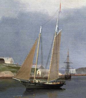
In the ninteenth century, the term "bark" was applied to a large sailing vessel having three masts, the first two (fore and main) being square-rigged; the third (mizzen), fore-and-aft rigged. The reduced square-rig made the vessel easier and more economical to handle, using a smaller crew. (1)
Barks had significant presence in mid-nineteenth-century America, as indicated by Lane’s depictions of them. Hardly any are to be found in his scenes of major ports, but some do appear in his Cape Ann scenes (see The Fort and Ten Pound Island, Gloucester (Harbor Scene), 1848 (inv. 58), View of Gloucester, 1859 (inv. 91), Gloucester Harbor, 1850s (inv. 391), and Bark "Eastern Star" of Boston, 1853 (inv. 571)), also in views of other small ports and of coastal shipping (see Clipper Ship "Southern Cross" in Boston Harbor, 1851 (inv. 253), Merchantmen Off Boston Harbor, 1853 (inv. 267), Approaching Storm, Owl's Head, 1860 (inv. 399), and Bark "Mary", n.d. (inv. 629)).
Brigs, and to a lesser extent ships, were the vessels of choice for Gloucester’s foreign trade in the first half of the nineteenth century. They brought cargos from the West Indies, South America, and Europe, anchoring in the deeper parts of the Inner Harbor while lighters off-loaded the goods and landed them at the wharves in Harbor Cove, by then too shallow for the newer, larger merchant vessels coming into use. (2) By mid-century, barks were gradually replacing brigs and ships, while the trade with Surinam was removed to Boston in 1860. (3)
Some bulk cargos still had to be landed in Gloucester, salt for curing fish being the most important. “Salt barks” brought Tortugas salt from the West Indies, and in the 1870s, Italian salt barks began bringing Trapani salt from Sicily. The importation of salt by sailing ships ended with the outbreak of World War I. (4)
The term barkentine, like the bark, pre-dates the nineteenth century, but in the mid- to late 1800s referred to a large vessel of three masts (or more), with only the fore mast square-rigged, the others being fore-and-aft-rigged. In Lane’s time, the term was little known in the United States, while many other names were coined for the rig. One of these early terms was demi-bark, probably from the French demi-barque, which was applied to a very different kind of vessel. (5) Lane’s depictions of these rigs include a lithograph of the steam demi-bark "Antelope" View of Newburyport, (From Salisbury), 1845 (inv. 499) and at least three depictions of Cunard steamships The "Britannia" Entering Boston Harbor, 1848 (inv. 49), Cunard Steamship Entering Boston Harbor, n.d. (inv. 197), and Cunard Liner "Britannia", 1842 (inv. 259). (6) None of these subjects typify the barkentine rig as applied to sails-only rigs as they developed in the years after Lane’s death.
– Erik Ronnberg (May, 2015)
References:
1. R[ichard] H[enry] Dana, Jr., The Seaman's Friend (Boston; Thomas Groom & Co., 1841. 13th ed., 1873), 97 and Plate IV with captions; and M.H. Parry, et al., Aak to Zumbra: A Dictionary of the World's Watercraft (Newport News, VA: The Mariners’ Museum, 2000), 43.
2. Alfred Mansfield Brooks, Gloucester Recollected (Gloucester, MA: Peter Smith, 1974), 56, note 10; 67, note 7.
3. James R. Pringle, History of the Town and City of Gloucester (1892. Reprint: Gloucester, MA, 1997), 106–08.
4. Raymond McFarland, A History of the New England Fisheries (Philadelphia: University of Pennsylvania, 1911), 95–96; and Mark Kurlansky, Salt: A World History (New York: Walker & Co., 2002), 419–420.
5. Parry, 44, 167. Dana has neither definition nor illustration of this rig.
6. J[ohn] W. Griffiths, “The Japan and China Propeller Antelope," U.S. Nautical Magazine III (October 1855): 11–17. This article includes an impression of Lane’s lithograph on folded tissue.
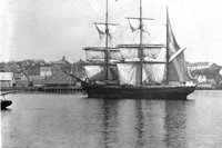
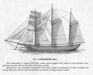
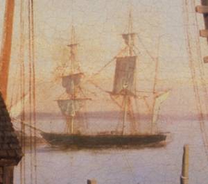
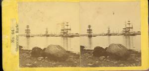
c.1875 Stereograph card Cape Ann Museum Library & Archive
This view of Gloucester's Inner Harbor shows three square-rigged vessels in the salt trade at anchor. The one at left is a (full-rigged) ship; the other two are barks. By the nature of their cargos, they were known as "salt ships" and "salt barks" respectively. Due to their draft (too deep to unload at wharfside) they were partially unloaded at anchor by "lighters" before being brought to the wharves for final unloading.
– Erik Ronnberg
Also filed under: Historic Photographs » // Salt » // Waterfront, Gloucester »
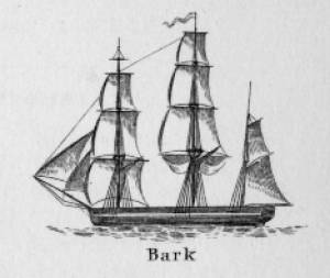

In general, brigs were small to medium size merchant vessels, generally ranging between 80 and 120 feet in hull length. Their hull forms ranged from sharp-ended (for greater speed; see Brig "Antelope" in Boston Harbor, 1863 (inv. 43)) to “kettle-bottom” (a contemporary term for full-ended with wide hull bottom for maximum cargo capacity; see Ships in Ice off Ten Pound Island, Gloucester, 1850s (inv. 44) and Boston Harbor, c.1850 (inv. 48)). The former were widely used in the packet trade (coastwise or transoceanic); the latter were bulk-carriers designed for long passages on regular routes. (1) This rig was favored by Gloucester merchants in the Surinam Trade, which led to vessels so-rigged being referred to by recent historians as Surinam brigs (see Brig "Cadet" in Gloucester Harbor, late 1840s (inv. 13) and Gloucester Harbor at Dusk, c.1852 (inv. 563)). (2)
Brigs are two-masted square-rigged vessels which fall into three categories:
Full-rigged brigs—simply called brigs—were fully square-rigged on both masts. A sub-type—called a snow—had a trysail mast on the aft side of the lower main mast, on which the spanker, with its gaff and boom, was set. (3)
Brigantines were square-rigged on the fore mast, but set only square topsails on the main mast. This type was rarely seen in America in Lane’s time, but was still used for some naval vessels and European merchant vessels. The term is commonly misapplied to hermaphrodite brigs. (4)
Hermaphrodite brigs—more commonly called half-brigs by American seamen and merchants—were square-rigged only on the fore mast, the main mast being rigged with a spanker and a gaff-topsail. Staysails were often set between the fore and main masts, there being no gaff-rigged sail on the fore mast.
– Erik Ronnberg
References:
1. Howard I. Chapelle, The National Watercraft Collection (Washington, DC: Smithsonian Institution, 1960), 64–68.
2. Alfred Mansfield Brooks, Gloucester Recollected: A Familiar History (Gloucester, MA: Peter Smith, 1974), 62–74. A candid and witty view of Gloucester’s Surinam Trade, which employed brigs and barks.
3. R[ichard] H[enry] Dana, Jr., The Seaman's Friend (Boston: Thomas Groom & Co., 1841. 13th ed., 1873), 100 and Plate 4 and captions; and M.H. Parry, et al., Aak to Zumbra: A Dictionary of the World's Watercraft (Newport News, VA: The Mariners’ Museum, 2000), 95.
4. Parry, 95, see Definition 1.
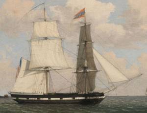
Oil on canvas
17 1/4 x 25 3/4 in.
Cape Ann Museum, Gloucester, Mass., Gift of Isabel Babson Lane, 1946 (1147.a)
Photo: Cape Ann Museum
Detail of brig "Cadet."
Also filed under: "Cadet" (Brig) »
Painting on board
72 x 48 in.
Collection of Erik Ronnberg
Chart showing the voyage of the brig Cadet to Surinam and return, March 10–June 11, 1840.
Also filed under: "Cadet" (Brig) » // Surinam Trade »
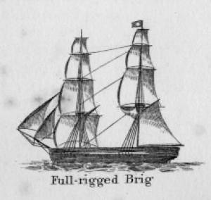
The colonial American shallop is the ancestor of many regional types of New England fishing craft found in Lane's paintings and drawings, including "New England Boats" (known as "boats"), and later descendents, such as "Chebacco Boats," "Dogbodies," and "Pinkies." (discussed elsewhere)
These boats were very common work boat types on Cape Ann throughout the 1800s. They were primarily used for inshore coastal fishing, which included lobstering, gill-netting, fish-trapping, hand-lining, and the like. They were usually sailed by one or two men, sometimes with a boy, and could be rowed as well as sailed. An ordinary catch would include rock cod, flounder, fluke, dabs, or other small flat fish. The catch would be eaten fresh, or salted and stored for later consumption, or used as bait fish. Gill-netting would catch herring and alewives when spawning. Wooden lobster traps were marked with buoys much as they are today, and hauled over the low sides of the boat, emptied of lobsters and any by-catch, re-baited and thrown back.
THE SHALLOP
Like other colonial vessel types, shallops were defined in many ways, including size, construction, and rig. Most commonly, they were open boats with square or sharp sterns, 20 to 30 feet in length, two-masted rigs, and heavy sawnframe construction which in time became lighter. (1)
The smaller shallops developed into a type called the Hampton Boat early in the nineteenth century, becoming the earliest named regional variant of what is now collectively termed the New England Boat. Other variants were named for their regions of origin: Isles of Shoals Boat, Casco Bay Boat, No Mans Land Boat, to name a few. No regional name for a Cape Ann version has survived, and "boat," or "two-masted boat" seems to have sufficed. (2)
Gloucester's New England Boats were mostly double-enders (sharp sterns) ranging in length from 25 to 30 feet, with two masts and two sails (no bowsprit or jib). They were used in the shore fisheries: handlining, gillnetting, and gathering or trapping shellfish (see View from Kettle Cove, Manchester-by-the-Sea, 1847 (inv. 94), View of Gloucester Harbor, 1848 (inv. 97), and /entry: 240/). (3)
Larger, double-ended shallops became decked and evolved in Ipswich (the part now called Essex) to become Chebacco Boats. (4) This variant retained the two-mast, two-sail rig, but evolved further, acquiring a bowsprit and jib and becoming known as a pinky (see Gloucester Harbor from Rocky Neck, 1844 (inv. 14), The Western Shore with Norman's Woe, 1862 (inv. 18), and The Old Fort and Ten Pound Island, Gloucester, 1850s (inv. 30)). The Chebacco Boat became a distinct type by the mid-eighteenth century giving rise to the pinky in the early ninetennth century; the latter, by the early 1900s. (5)
References:
1. William A. Baker, Sloops & Shallops (Barre, MA: Barre Publishing Co., 1966), 27–33; and “Vessel Types of Colonial Massachusetts,” in Seafaring in Colonial Massachusetts (Boston: The Colonial Society of Massachusetts, 1980), 13–15, see figs. 10, 11.
2. Howard I. Chapelle, American Small Sailing Craft (New York: W.W. Norton & Co., 1951), 136–45.
3. Ibid., 145, upper photo, fourth page of plates.
4. Baker, 82–91.
5. Chapelle, The American Fishing Schooners, 1825–1935 (New York: W.W. Norton & Co., 1973), 23–54.
THE NEW ENGLAND BOAT
By the 1840s, the Gloucester version of the New England Boat had evolved into a distinct regional type. Referred to locally as “boats,” the most common version was a double-ender, i.e. having a pointed stern, unlike the less common version having a square stern.
Both variants had two masts, a foresail, a mainsail, but no bowsprit or jib. Lane depicted both in several paintings, beginning in the mid-1840s (see View from Kettle Cove, Manchester-by-the-Sea, 1847 (inv. 94), View of Gloucester Harbor, 1848 (inv. 97), and /entry: 240/), all ranging 25 to 30 feet in length. In View of Gloucester Harbor, 1848 (inv. 97) and Gloucester Inner Harbor, 1850 (inv. 240), a double-ender can be seen on the beach while a square-stern version lies at anchor in the harbor, just to the right of the former. (1)
Lane’s depictions of the double-enders show lapstrake hull planking in View of Gloucester Harbor, 1848 (inv. 97) and Gloucester Inner Harbor, 1850 (inv. 240), and cuddies (short decking) inboard at the ends for shelter and stowage of fishing gear in View from Kettle Cove, Manchester-by-the-Sea, 1847 (inv. 94). The few square-stern examples (see View of Gloucester Harbor, 1848 (inv. 97) and Gloucester Inner Harbor, 1850 (inv. 240)) suggest carvel (smooth) planking and paint finish, rather than oil and tar. The presence of an example of the latter variant in Boston Harbor, as noted in Boston Harbor, c.1850 (inv. 48), suggests a broader geographical range for this subtype. (2)
The primary use of Cape Ann’s “boats” was fishing, making “day trips” to coastal grounds for cod, herring, mackerel, hake, flounder, and lobster, depending on the season. Fishing gear included hooks and lines, gill nets, and various traps made of wood and fish net.
Some boats worked out of Gloucester Harbor, but other communities on Cape Ann had larger fleets, such as Sandy Bay, Pigeon Cove, Folly Cove, Lanesville, Bay View, and Annisquam. Lane’s depictions of these places and their boats are rare to nonexistent. (3)
The double-ended boat served Lane in marking the passage of time in Gloucester Harbor. In View from Kettle Cove, Manchester-by-the-Sea, 1847 (inv. 94), we see new boats setting out to fish, but in View of Gloucester Harbor, 1848 (inv. 97) and Gloucester Inner Harbor, 1850 (inv. 240), a boat of the same type is depicted in a progressively worn state. In Stage Fort across Gloucester Harbor, 1862 (inv. 237), the boat is a stove hulk on a beach, and in the same year, Lane depicted the type’s shattered bottom frame and planking lying on the shore at Norman’s Woe in Norman's Woe, Gloucester Harbor, 1862 (inv. 1).
Regional variants of the New England Boat appear in Lane’s paintings of Maine harbors, including one and two-masted versions, collectively called Hampton Boats (see Bear Island, Northeast Harbor, 1855 (inv. 24), Ten Pound Island at Sunset, 1851 (inv. 25), Fishing Party, 1850 (inv. 50), Father's (Steven's) Old Boat, 1851 (inv. 190), and "General Gates" at Anchor off Our Encampment at Bar Island in Somes Sound, Mount Desert, Maine, 1850 (inv. 192)). Some distinctive regional types were given names, i.e. Casco Bay Boats ("General Gates" at Anchor off Our Encampment at Bar Island in Somes Sound, Mount Desert, Maine, 1850 (inv. 192) may be one), but many local type names, if they were coined, have been lost. (4)
References:
1. Howard I. Chapelle, American Small Sailing Craft (New York: W.W. Norton & Co., 1951), 141–42.
2. Ibid., 152–55.
3. Sylvanus Smith, Fisheries of Cape Ann (Gloucester, MA: Press of the Gloucester Times, 1915), 96–97, 102–05, 110–13.
4. Chapelle, 152–55.
Also filed under: Ship Models »
Also filed under: Ship Models »
"Party boat" is a colloquial term for any kind of small craft adapted or used for taking guests (customarily for hire) on sightseeing trips or fishing for pleasure. (1) The term survives to this day on Cape Ann and other places for vessels engaged in the same activities. (2) In Lane's time, party boating was a calling of opportunity, and a fisherman's boat might be used in season - regularly or occasionally - to take "rusticators" fishing. Likewise, a boat used for its owner's own pleasure might be hired to take sightseers sailing for an afternoon. The latter use is seen in Lane's 1844 view of Gloucester Harbor from Rocky Neck (see the yawl-rigged sailboat in the foreground of Gloucester Harbor from Rocky Neck, 1844 (inv. 14)).
By the early 1850s, summer visitor activity, encouraged by the building of the Pavilion Hotel on Gloucester's waterfront, led to increased pleasure boating activity, if Lane's painting Gloucester Harbor, 1852 (inv. 38) of Pavilion Beach and Sidney Mason's hotel is any indication. (3) Lane's Gloucester Harbor scenes from this decade show a number of pleasure craft suitable for taking passengers for hire (see Fresh Water Cove from Dolliver's Neck, Gloucester, Early 1850s (inv. 45), Coming Ashore near Brace's Rock, Gloucester, Massachusetts, c.1860 (inv. 60), and View of Gloucester from "Brookbank," the Sawyer Homestead, c.1856 (inv. 95)). Small working craft suitable for this purpose are seen in The Old Fort and Ten Pound Island, Gloucester, 1850s (inv. 30), Gloucester Harbor, 1852 (inv. 38) (right foreground), View of Gloucester, 1859 (inv. 91) (foreground), and Watch House Point, 1860 (inv. 292) (right foreground). In View of Gloucester Harbor, 1848 (inv. 97), we see passengers boarding a small sloop-rigged boat hidden by the rocks at Duncan's Point (left middle ground).
In coastal waters south of Gloucester, a few of Lane's paintings offer pleasure craft as candidates for taking paying passengers. Phantom of Boston, c.1850s (inv. 574) depicts a cruising yawl "Phantom" of Boston, beached with hunting gear unloaded alongside while two of the crew await an approaching party in a rowing boat. The location is unidentified, but a possibility is the barrier beach around the marshes of Lynn, Massachusetts, which were once very popular hunting grounds for migrating waterfowl. A second candidate is a small sloop with a party of four on an evening sail off Halfway Rock in Becalmed Off Halfway Rock, 1860 (inv. 344) (far right).
Lane found similar uses of working watercraft in Maine, where the families of a small coastal community would travel by their workboats to a gathering place for a clambake or similar festive outing (see View of Indian Bar Cove, Brooksville, Maine, 1850 (inv. 61)). The artist became a "rusticator" himself when he, Joseph Stevens, and friends explored Mount Desert Island and vicinity in the "General Gates," a sloop-rigged Maine version of a New England Boat (View of Bar Island and Mount Desert Mountains, from the Bay in Front of Somes Settlement, 1850 (inv. 177) and Castine Harbor and Town, 1851 (inv. 272)).
When Lane traveled to New Bedford in 1856 to observe and sketch a regatta held by the New York Yacht Club, he observed and sketched it while on board an unknown vessel near the starting and finishing line, formed by the race committee boat "Emblem" and her yawl-boat.
Close by was a small party boat with observers on board, probably a fishing sloop, given its work-a-day looks. In the ensuing year, Lane painted four detailed views of this race, the party boat appearing in New York Yacht Club Regatta (1), 1856 (inv. 66) (right foreground); New York Yacht Club Regatta (2), 1856 (inv. 270) (right margin); New York Yacht Club Regatta (3), After 1856 (inv. 396) (center); and New York Yacht Club Regatta (4), 1857 (inv. 397) (left foreground). (4)
– Erik Ronnberg
References:
1. M. H. Parry and others, Aak to Zumbra: A Dictionary of the World's Watercraft (Newport News, VA: The Mariners' Museum, 2000), 436.
2. Ibid.
3. Proctor's Able Sheet (a Gloucester newspaper), January 1857: "Gloucester House reopened—refitted—boats always ready to take parties cruising or fishing..."
4. John Wilmerding, Fitz Henry Lane, 2nd ed. (Cape Ann, MA: Cape Ann Historical Association, 2005), 52–54. Lane's 1852 cruise in the Mount Desert region in the sloop "Superior" was reprinted as an appendix to Wilmerding's essay in Paintings by Fitz Hugh Lane (Washington, DC: National Gallery of Art, 1988), 125–26.
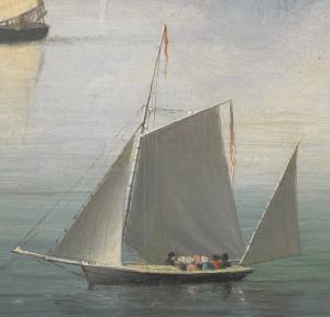
Oil on canvas
34 x 45 3/4 in.
Cape Ann Museum, Gloucester, Mass., Gift of Mrs. Jane Parker Stacy (Mrs. George O. Stacy),1948 (1289.1a)
Detail of party boat.
Also filed under: Gloucester Harbor, Inner / Harbor Cove »

Oil on canvas
22 x 36 in.
Cape Ann Museum, Gloucester, Mass., deposited by the Collection of Addison Gilbert Hospital, 1978 (DEP. 201)
Detail of party boat.
Also filed under: Ten Pound Island »
Newspaper
Ad in Gloucester Telegraph
FISHING AND SAILING PARTIES
"Persons desirous of enjoying a SAILING or FISHING EXCURSION, are informed that the subscriber will be in readiness with the Boat EUREKA, to attend to all who may favor him with their patronage. JOHN J. FERSON"
Also filed under: Gloucester Harbor – Use » // Newspaper / Journal Articles »
Newsprint
Ad for Gloucester House
Courtesy of the American Antiquarian Society, Worcester, Mass.
See p. 4, column 2.
Also filed under: Brick Houses / Gloucester House Hotel » // Newspaper / Journal Articles »
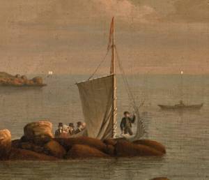
Schooners in Lane’s time were, with few exceptions, two-masted vessels carrying a fore-and-aft rig having one or two jibs, a fore staysail, gaff-rigged fore- and main sails, and often fore- and main topsails. One variant was the topsail schooner, which set a square topsail on the fore topmast. The hulls of both types were basically similar, their rigs having been chosen for sailing close to the wind. This was an advantage in the coastal trade, where entering confined ports required sailing into the wind and frequent tacking. The square topsail proved useful on longer coastwise voyages, the topsail providing a steadier motion in offshore swells, reducing wear and tear on canvas from the slatting of the fore-and-aft sails. (1)
Schooners of the types portrayed by Lane varied in size from 70 to 100 feet on deck. Their weight was never determined, and the term “tonnage” was a figure derived from a formula which assigned an approximation of hull volume for purposes of imposing duties (port taxes) oncargoes and other official levies. (2)
Crews of smaller schooners numbered three or four men. Larger schooners might carry four to six if a lengthy voyage was planned. The relative simplicity of the rig made sail handling much easier than on a square-rigged vessel. Schooner captains often owned shares in their vessels, but most schooners were majority-owned by land-based firms or by individuals who had the time and business connections to manage the tasks of acquiring and distributing the goods to be carried. (3)
Many schooners were informally “classified” by the nature of their work or the cargoes they carried, the terminology coined by their owners, agents, and crews—even sometimes by casual bystanders. In Lane’s lifetime, the following terms were commonly used for the schooner types he portrayed:
Fishing Schooners: While the port of Gloucester is synonymous with fishing and the schooner rig, Lane depicted only a few examples of fishing schooners in a Gloucester setting. Lane’s early years coincided with the preeminence of Gloucester’s foreign trade, which dominated the harbor while fishing was carried on from other Cape Ann communities under far less prosperous conditions than later. Only by the early 1850s was there a re-ascendency of the fishing industry in Gloucester Harbor, documented in a few of Lane’s paintings and lithographs. Depictions of fishing schooners at sea and at work are likewise few. Only A Smart Blow, c.1856 (inv. 9), showing cod fishing on Georges Bank (4), and At the Fishing Grounds, 1851 (inv. 276), showing mackerel jigging on Georges Bank, are known examples. (5)
– Erik Ronnberg
References:
1. Howard I. Chapelle, The History of American Sailing Ships (New York: W.W. Norton & Co., 1935), 258. While three-masted schooners were in use in Lane’s time, none have appeared in his surviving work; and Charles S. Morgan, “New England Coasting Schooners”, The American Neptune 23, no. 1 (DATE): 5–9, from an article which deals mostly with later and larger schooner types.
2. John Lyman, “Register Tonnage and its Measurement”, The American Neptune V, nos. 3–4 (DATE). American tonnage laws in force in Lane’s lifetime are discussed in no. 3, pp. 226–27 and no. 4, p. 322.
3. Ship Registers of the District of Gloucester, Massachusetts, 1789–1875 (Salem, MA: The Essex Institute, 1944). Vessels whose shipping or fishing voyages included visits to foreign ports were required to register with the Federal Customs agent at their home port. While the vessel’s trade or work was unrecorded, their owners and master were listed, in addition to registry dimensions and place where built. Records kept by the National Archives can be consulted for information on specific voyages and ports visited.
4. Howard I. Chapelle, The National Watercraft Collection (Washington, DC: Smithsonian Institution, 1960), 74–76.
5. Howard I. Chapelle, The American Fishing Schooners (New York: W.W. Norton & Co., 1973), 58–75, 76–101.
1852
Oil on canvas
28 x 48 1/2 in.
Cape Ann Museum, Gloucester, Mass., Deposited by the City of Gloucester, 1952. Given to the city by Mrs. Julian James in memory of her grandfather Sidney Mason, 1913 (DEP. 200)
Detail of fishing schooner.
Also filed under: Gloucester Harbor, Inner / Harbor Cove »
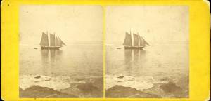
c.1865 Stereograph card Frank Rowell, Publisher stereo image, "x " on card, "x" Cape Ann Museum Library & Archive
View showing a sharpshooter fishing schooner, circa 1850. Note the stern davits for a yawl boat, which is being towed astern in this view.
Also filed under: Historic Photographs »
Model made for marine artist Thomas M. Hoyne
scale: 3/8" = 1'
Thomas M. Hoyne Collection, Mystic Seaport, Conn.
While this model was built to represent a typical Marblehead fishing schooner of the early nineteenth century, it has the basic characteristics of other banks fishing schooners of that region and period: a sharper bow below the waterline and a generally more sea-kindly hull form, a high quarter deck, and a yawl-boat on stern davits.
The simple schooner rig could be fitted with a fore topmast and square topsail for making winter trading voyages to the West Indies. The yawl boat was often put ashore and a "moses boat" shipped on the stern davits for bringing barrels of rum and molasses from a beach to the schooner.
– Erik Ronnberg
References:
Jeffrey Bolster, Black Jacks: African American Seafarers in the Age of Sail (Cambridge, MA: Harvard University Press, 1997).
Howard I. Chapelle, American Small Sailing Craft (New York: W.W. Norton & Co., 1951), 29–31.
Also filed under: Hand-lining » // Ship Models »

20 x 14 in.
Cape Ann Museum Library & Archive, Gloucester, Mass.
The image, as originally drafted, showed only spars and sail outlines with dimensions, and an approximate deck line. The hull is a complete overdrawing, in fine pencil lines with varied shading, all agreeing closely with Lane's drawing style and depiction of water. Fishing schooners very similar to this one can be seen in his painting /entry:240/.
– Erik Ronnberg
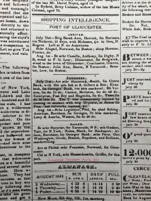
Newspaper
"Shipping Intelligence: Port of Gloucester"
"Fishermen . . . The T. [Tasso] was considerably injured by coming in contact with brig Deposite, at Salem . . ."
Also filed under: Newspaper / Journal Articles »
Newsprint
From bound volume owned by publisher Francis Procter
Collection of Fred and Stephanie Buck
"A Prize Race—We have heard it intimated that some of our fishermen intend trying the merits of their "crack" schooners this fall, after the fishing season is done. Why not! . . .Such a fleet under full press of sail, would be worth going many a mile to witness; then for the witchery of Lane's matchless pencil to fix the scene upon canvass. . ."
Also filed under: Fishing » // Newspaper / Journal Articles »
Also filed under: Cape Ann Advertiser Masthead »
c.1870 Stereograph card Procter Brothers, Publisher Cape Ann Museum Library & Archive
"Gloucester Harbor from Rocky Neck, Looking Southwest. This gives a portion of the Harbor lying between Ten Pound Island and Eastern Point. At the time of taking this picture the wind was from the northeast, and a large fleet of fishing and other vessels were in the harbor. In the range of the picture about one hundred vessels were at anchor. In the small Cove in the foreground quite a number of dories are moored. Eastern Point appears on the left in the background."
Southeast Harbor was known for being a safe harbor.
Also filed under: Gloucester Harbor, Outer » // Historic Photographs » // Rocky Neck » // Small Craft – Wherries, and Dories »
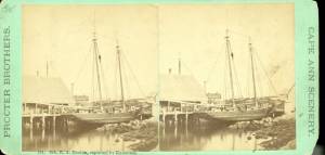
1870s Stereograph card Cape Ann Museum Library & Archive
"Said schooner was captured about the first of September, 1871, by Capt. Torry, of the Dominion Cutter 'Sweepstakes,' for alleged violation of the Fishery Treaty. She was gallantly recaptured from the harbor of Guysboro, N.S., by Capt. Harvey Knowlton., Jr., (one of her owners,) assisted by six brave seamen, on Sunday night, Oct. 8th. The Dominion Government never asked for her return, and the United States Government very readily granted her a new set of papers."
Also filed under: Fishing » // Historic Photographs » // Waterfront, Gloucester »
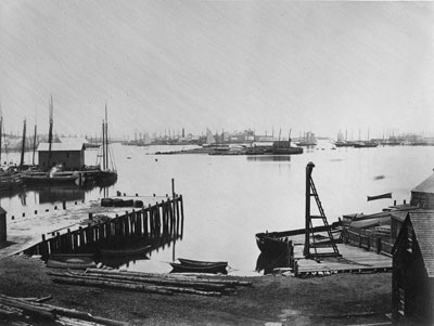
1876 Photograph Cape Ann Museum Library & Archive
Also filed under: Gloucester Harbor, Inner / Harbor Cove » // Historic Photographs » // Waterfront, Gloucester »

c.1870 Cape Ann Museum Library & Archive (2013.068)
Schooner fleet anchored in the inner harbor. Looking east from Rocky Neck, Duncan's Point wharves and Lane house (at far left), Sawyer School cupola on Friend Street.
Also filed under: Duncan's Point » // Gloucester Harbor, Inner / Harbor Cove » // Historic Photographs » // Waterfront, Gloucester »
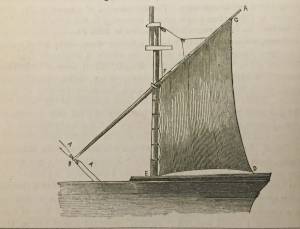
See p. 254.
As Erik Ronnberg has noted, Lane's engraving follows closely the French publication, Jal's "Glossaire Nautique" of 1848.
Also filed under: Babson History of the Town of Gloucester »
Wood, cordage, acrylic paste, metal
~40 in. x 30 in.
Erik Ronnberg
Model shows mast of fishing vessel being unstepped.
Also filed under: Burnham Brothers Marine Railway » // Fishing »
Watercolor on paper
8 3/4 x 19 3/4 in.
Cape Ann Museum, Gloucester, Mass., Gift of Rev. and Mrs. A. A. Madsen, 1950
Accession # 1468
Fishing schooners in Gloucester's outer harbor, probably riding out bad weather.
Also filed under: Elwell, D. Jerome » // Gloucester Harbor, Outer »
1876 Photograph Cape Ann Museum Library & Archive
Ignatius Weber's windmill (now defunct) is shown.
Also filed under: Flake Yard » // Fort (The) and Fort Point » // Gloucester Harbor, Inner / Harbor Cove » // Historic Photographs » // Rogers's (George H.) wharves » // Waterfront, Gloucester » // Windmill »
Print from bound volume of Gloucester scenes sent to the Philadelphia Centennial Exhibition.
11 x 14 in.
Cape Ann Museum Library & Archives
Schooner "Grace L. Fears" at David A. Story Yard in Vincent's Cove.
Also filed under: Historic Photographs » // Shipbuilding / Repair » // Vincent's Cove »
The term “wherry”—variously spelled—has a long history with many hull types, some dating from the fifteenth century. (1) The version known to Lane appears to be a variant of the dory hull form and probably was developed by French and English fishermen in the Newfoundland fisheries before 1700. (2) From that time, the wherry and the dory co-evolved, their similarities the result of their construction, their differences the result of use. By the early nineteenth century, their forms reached their final states, if fragments of contemporary descriptions are any indication. (3)
By the time Lane was depicting wherries, the type (as used for fishing) resembled a larger, wider version of a dory. The extra width was due to greater bottom width (both types had flat bottoms), with a wider transom at the stern instead of the narrow, v-shaped “tombstone.” These features are easy to see in one of his drawings (see Three Men, One in a Wherry, n.d. (inv. 225)) and a painting (see Sunrise through Mist, 1852 (inv. 98)), the latter depicted alongside a dory, clearly showing the differences.
No published descriptions of the uses of wherries on Cape Ann in Lane’s time have come to light, but an example in broadside view offers one use. In Becalmed Off Halfway Rock, 1860 (inv. 344), a pinky (in right foreground) has a dory and a wherry in tow, the latter loaded with a gill net for catching mackerel. (4) The greater size of the wherry is required for stowing the net, as well as setting it while the dory tows away one end to set it in way of the mackerel school.
In Lane’s time, wherries would have been used where bulky gear was called for in the coastal fisheries, i.e. gill nets, and fish traps such as pound nets, fyke nets, and lobster traps. Migrating fish schools (herring, mackerel) and shellfish were the target species.
The dory’s development was first dictated by its use in shore fishing, where small size and light weight made it easy to maneuver around rocks and shallows, and to haul ashore at the end of a day’s work. Its simple design made it easy and cheap to build. This is borne out by the standardized construction and sizes used by Simon Lowell’s boat shop at Salisbury Point, Massachusetts at the turn of the nineteenth century. Lowell called his boats “wherries,” but in Swampscott, Massachusetts, the fishermen, who used them called them “dories,” which may mark the beginning of the latter term’s wider use. (5)
The dories we see in Lane’s paintings are in virtually every way like the ones we know today. One of the best examples (see View from Kettle Cove, Manchester-by-the-Sea, 1847 (inv. 94)) even shows interior detail, including frames, leaving no doubt about its construction. Other good examples are found in Salem Harbor, 1853 (inv. 53), View of Gloucester Harbor, 1848 (inv. 97), and Sunrise through Mist, 1852 (inv. 98).
For inshore fishing, dories were used to catch mackerel and herring, either with hook and line or with small nets. Hooks and line were used for flat fish (flounder, dab, and fluke), rock cod, hake, and cunner. Eels were speared (see View from Kettle Cove, Manchester-by-the-Sea, 1847 (inv. 94)), clams were dug, and lobsters trapped. In Lane’s later years, the use of dories in trawling (setting long “trawl lines” with many baited hooks) was in its earliest. This method required six to ten dories carried on board a schooner to fish on the distant banks off New England and Canada. Early records of dory trawling in New England are fragmentary, giving the mid-1840s as the time of introduction. (6) The Gloucester-owned schooner "Anna" made a successful dory trawling trip to the Grand Banks in 1854, but no depiction of this vessel by Lane has been found or recorded. (5) Despite successful early efforts, dory trawling from Gloucester was slow to be accepted, and the fishery had very limited growth prior to 1860. (7)
– Erik Ronnberg
References:
1. M.H. Parry et al., Aak to Zumbra (Newport News, VA: The Mariners’ Museum, 2000), 634.
2. John Gardner, The Dory Book (Camden, ME: International Marine Publishing Company, 1978), 5–9.
3. Ibid., 25–29.
4. John Wilmerding, ed., Paintings by Fitz Hugh Lane (Washington, DC: National Gallery of Art, 1988), 89, 92. The “possibly discarded whaleboat” is definitely a wherry.
5. Gardner, 9, 10.
6. Wesley George Pierce, Goin’ Fishin’ (Salem, MA: Marine Research Society, 1934), 63–64.
7. Raymond McFarland, A History of New England Fisheries (Philadelphia: University of Pennsylvania, 1911), 279.
c.1870 Stereograph card Procter Brothers, Publisher Cape Ann Museum Library & Archive
"Gloucester Harbor from Rocky Neck, Looking Southwest. This gives a portion of the Harbor lying between Ten Pound Island and Eastern Point. At the time of taking this picture the wind was from the northeast, and a large fleet of fishing and other vessels were in the harbor. In the range of the picture about one hundred vessels were at anchor. In the small Cove in the foreground quite a number of dories are moored. Eastern Point appears on the left in the background."
Southeast Harbor was known for being a safe harbor.
Also filed under: Gloucester Harbor, Outer » // Historic Photographs » // Rocky Neck » // Schooner (Fishing) »
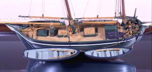
Also filed under: Chebacco Boat / Dogbody / Pinky » // Ship Models »
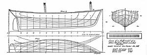
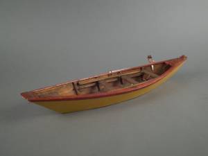
Gloucester, MA
4 x 33 1/2 x 7 1/4 in (10.16 x 85.09 x 18.415 cm)
Peabody Essex Museum
Also filed under: Objects » // Ship Models »
The yawl boat was a ninteenth-century development of earlier ships' boats built for naval and merchant use. Usually twenty feet long or less, they had round bottoms and square sterns; many had raking stem profiles. Yawl boats built for fishing tended to have greater beam than those built for vessels in the coastal trades. In the hand-line fisheries, where the crew fished from the schooner's rails, a single yawl boat was hung from the stern davits as a life boat or for use in port. Their possible use as lifeboats required greater breadth to provide room for the whole crew. In port, they carried crew, provisions, and gear between schooner and shore. (1)
Lane's most dramatic depictions of fishing schooners' yawl-boats are found in his paintings Gloucester Outer Harbor, from the Cut, 1850s (inv. 109) and /entry:311. Their hull forms follow closely that of Chapelle's lines drawing. (2) Similar examples appear in the foregrounds of Gloucester Harbor, 1852 (inv. 38), Ships in Ice off Ten Pound Island, Gloucester, 1850s (inv. 44), and The Fort and Ten Pound Island, Gloucester, Massachusetts, 1847 (inv. 271). A slightly smaller example is having its bottom seams payed with pitch in the foreground of Gloucester Harbor, 1847 (inv. 23). In Gloucester Inner Harbor, 1850 (inv. 240), a grounded yawl boat gives an excellent view of its seating arrangement, while fishing schooners in the left background have yawl boats hung from their stern davits, or floating astern.
One remarkable drawing, Untitled, n.d. (inv. 219) illustrates both the hull geometry of a yawl boat and Lane's uncanny accuracy in depicting hull form in perspective. No hull construction other than plank seams is shown, leaving pure hull form to be explored, leading in turn to unanswered questions concerning Lane's training to achieve such understanding of naval architecture.
– Erik Ronnberg
References:
1. Howard I. Chapelle, American Small Sailing Craft (New York: W.W. Norton & Co., 1951), 222–23.
2. Ibid., 223.
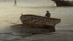
Oil on canvas
12 1/8 x 19 3/4 in.
Museum of Fine Arts, Boston, Bequest of Martha C. Karolik for the M.and M. Karolik Collection of American Paintings, 1815-1865 (48.447)
A schooner's yawl lies marooned in the ice-bound harbor in this detail.

Gill netting is a fishing method wherein a fish swims into a net, entangling its gill covers in the mesh and is thus unable to free itself. This method works especially well with smaller species (mackerel and herring) which swim in large schools near the surface and are caught in large numbers. Gill nets with larger mesh sizes have caught larger species, such as cod, but under special situations and with nets set at various depths. These nets came to the fisheries in the 1870s, the nets of Lane's time being set on the surface with wooden floats on their surface edges and weights on their bottom edges.
Lane's depiction of gill netting in Gloucester Harbor in the foreground of Gloucester Harbor, 1852 (inv. 38) could be for either mackerel or herring. A yawl boat (with sail) and a wherry are working with two separate nets which will probably be connected when the wherry has completed setting the one at left. The second net was probably set after the size and direction of the school was determined.
Gill netting in Ipswich Bay was done on a larger scale, using larger nets and larger boats. It was usual practice to leave the nets set overnight, hauling them at midnight and again in the morning. Night haulings involved the use of torches, whose light was a strong attraction to the fish and could significantly improve the catch. Ipswich Bay was lit up over much of its expanse by these lights on a busy summer night.
– Erik Ronnberg
In G. Brown Goode, The Fisheries and Fishery Industries of the United States (Washington, DC: Government Printing Office)
Cape Ann Museum Library & Archive, Gloucester, Mass.
Also filed under: Fishing »
In G. Brown Goode, The Fisheries and Fishery Industries of the United States (Washington, DC: Government Printing Office)
See pl. 45.
Underrunning cod gill-nets in Ipswich Bay, Mass.
Also filed under: Fishing »
Fishing and commerce came late to Gloucester Harbor, other harbors on Cape Ann having been developed sooner for these purposes. The rich and varied stocks of fish in Ipswich Bay and off Sandy Bay made the coves and harbors of Cape Ann's northern and eastern shores more convenient for shore fishermen in colonial times. The early successful permanent settlements on Cape Ann were in Annisquam Harbor and along the Annisquam River, leading to the establishment of Cape Ann's First Parish in that area. (1)
Shipbuilding in Gloucester Harbor began in the mid-seventeenth century, and by its end had produced a sizeable fleet of vessels which were active in the Grand Banks fishery. By the early 18th century, Gloucester Harbor was a busy fishing port becoming the economic center of Cape Ann—a reality finally recognized in 1740, when the First Parish built a new meeting house at the harbor, officially confirming its leading role. (2)
Gloucester's fishing enterprise was fueled by a demand for fish in Europe and their colonies in the West Indies. Vessels shipping fish to Europe returned with domestic wares and materials unavailable locally. Shipments of dried fish of lower grades went to plantations in the West Indies to feed their slaves; return cargos were usually sugar, molasses, and fine hardwoods to be used for cabinetry. By the 19th century, this trade had extended to Surinam, where fine Dutch domestic wares were added to the imports list. The Surinam Trade became Gloucester's dominant maritime activity in the first half of the nineteenth century. (3)
Success in the Surinam Trade led to using ever larger vessels to carry the goods - a problem for a shallow harbor with no dredging facilities. This forced Gloucester shipowners to move their port facilities and offices to Boston; after 1850, very few Surinam goods were landed at Gloucester. This opened Harbor Cove (Gloucester's prime port facility) to the fishing industry, just as momentous changes were to take place in fishing technology. (4)
Improvements to fishing methods and gear, namely dory trawling and mackerel seining, dramatically improved catches of cod and mackerel—at a cost. The gear was expensive. Gloucester was in a unique position to take advantage of this gear, thanks to banks and insurance firms with strong interests in the industry, local manufacturers of the new fishing gear, and a steady influx of young men eager for the work. The post-Civil War years saw a rapid rebuilding of Gloucester's fishing industry which could not be matched by rival New England fishing ports. (5)
– Erik Ronnberg
References:
1. Mary Ray, and Sarah V. Dunlap, Gloucester, Massachusetts Historical Time-line, 1000–1999 (Gloucester, MA: Archives, 2002), 10–16.
2. Ibid., 12, 17, 20, 24–25, 27–28, 30.
3. Alfred Mansfield Brooks, Gloucester recollected: A Familiar History (Gloucester, MA: Peter Smith, 1974), 50–69.
4. Ibid.
5. Wayne M. O'Leary, Maine Sea Fisheries (Boston: Northeastern University Press, 1996), 160–79.
Newspaper
Ad in Gloucester Telegraph
FISHING AND SAILING PARTIES
"Persons desirous of enjoying a SAILING or FISHING EXCURSION, are informed that the subscriber will be in readiness with the Boat EUREKA, to attend to all who may favor him with their patronage. JOHN J. FERSON"
Also filed under: Newspaper / Journal Articles » // Party Boat »
"Hand-lining" was fishing with a single line which had one or sometimes two hooks, as opposed to "trawling," in which a single line had many hooks. Hand-lining was the exclusive American fishing method from colonial times to the mid-19th century, and continued in use, taking second place to dory trawling only after the Civil War. Even then, it persisted into the twentieth century for some offshore fishing grounds, while hand-lining from dories remained a favored method for the shore fisheries.
Hand-line fishing on the offshore banks was done in relatively shallow water (10 to 45 fathoms), often over rocky bottom. This method depended on catching fish at mid-levels as well as on the bottom, hence the lines were relatively short, seldom longer than 75 fathoms. Each fisherman worked two lines, fishing from the schooner's rail. Bait could be salted clams, fresh-caught squid, and even birds.
Hand-lining by American schooners on the Grand Banks declined in the 1830s as they turned to Georges Bank to exploit that neglected resource. In doing so, they turned to a highly modified hand-lining gear using two hooks on a single line. The hooks were on a pair of long gangings (leaders), joined at the sinker and spread apart 12 to 18 inches by a metal rod (or wooden spreader) called a "sling ding." The hand-line itself was much longer - as much as 900 feet, allowing the gear to cover a broad area over a shallow sandy bottom with few obstructions.
On Georges Bank, the schooners anchored where the wind would set the vessels broadside to tidal currents, with the crew fishing from the down-current side. This allowed the lines to be paid out without getting tangled with each other or bunching up astern. The long hand-lines, combined with heavy sinkers and (hopefully) two large cod on the hooks made for strenuous hauling, made all the more so by the tidal current. Georges fishermen were regarded as the strongest in the Cape Ann fisheries.
The wealth of resources and the proximity of Georges Bank was offset by its hazards in heavy weather, as many of Gloucester's widows could testify. Breaking shallows, mountainous waves and winter storms took their toll, but this danger was compounded when numerous vessels anchored within sight of each other. A parted anchor cable could send a vessel crashing into another with the loss of both with their crews.
Steel engraving after drawing in G. Brown Goode, The Fisheries and Fishery Industries of the United States (Washington, DC: Government Printing Office)
8 1/2 x 11 in. (page size)
Cape Ann Museum Library & Archive, Gloucester, Mass.
See pl. 31.
Shows the two basic types of hand-line gear in use in mid-ninteenth century. At left is the Georges gear, developed for fishing on Georges Bank. At right is shoal water gear, as commonly used in the inshore fisheries using dories and other small craft. The spreader, or "sling-ding" was used on this type of gear with the advent of dory hand-lining on offshore grounds.
Also filed under: Cod / Cod Fishing »
Steel engraving after drawing in G. Brown Goode, The Fisheries and Fishery Industries of the United States (Washington, DC: Government Printing Office, 1883)
8 1/2 x 11 in. (page size)
Cape Ann Museum Library & Archive, Gloucester, Mass.
See pl. 32.
Also filed under: Cod / Cod Fishing » // Georges Bank, Mass. »
Model made for marine artist Thomas M. Hoyne
scale: 3/8" = 1'
Thomas M. Hoyne Collection, Mystic Seaport, Conn.
While this model was built to represent a typical Marblehead fishing schooner of the early nineteenth century, it has the basic characteristics of other banks fishing schooners of that region and period: a sharper bow below the waterline and a generally more sea-kindly hull form, a high quarter deck, and a yawl-boat on stern davits.
The simple schooner rig could be fitted with a fore topmast and square topsail for making winter trading voyages to the West Indies. The yawl boat was often put ashore and a "moses boat" shipped on the stern davits for bringing barrels of rum and molasses from a beach to the schooner.
– Erik Ronnberg
References:
Jeffrey Bolster, Black Jacks: African American Seafarers in the Age of Sail (Cambridge, MA: Harvard University Press, 1997).
Howard I. Chapelle, American Small Sailing Craft (New York: W.W. Norton & Co., 1951), 29–31.
Also filed under: Schooner (Fishing) » // Ship Models »
Sidney Mason (1799–1871) was the second of the four sons of John Mason and Phene Shipley. One of his brothers, Alphonso, was killed in the famous disaster of the burning of the steamship "Lexington." His father was master of the Gloucester workhouse, and a tavern keeper who owned the Puritan House hotel. His father, John Mason, was also the cartographer who drew the 1830/31 map of Gloucester. Lane may have been paid to color this map for sale by W.E.P. Rogers.
At the age of twelve, Sidney went to Boston, where he got a job polishing brasses. Over the course of several years, he rose to the position of clerk. In 1820, he went to the West Indies as supercargo and settled in San Juan, Puerto Rico, where he became a wealthy sugar merchant. From 1829 to 1835, he was also the first United Sates Consul in San Juan and it was there that he met and married his first wife Marequita B. Dorado. They had two children, Catalina Julia and Sidney Alphonso, and returned to live in Gloucester where Marequita died in 1835.
After her death, Sidney installed his children in American schools and embarked on an extensive tour of Europe, only returning on the death of his son in 1841. He took up residence in New York, and two years later he married Catherine Gartz Robb, a schoolmate of his daughter. She outlived him by several decades, retiring to Paris, where she ran a small hotel “frequented by the musical and artistic celebrities of the day.” (1)
His daughter Catalina married Theodorus Bailey Myers. It was their daughter, Cassie Mason Mayers, who married Julian James, and in 1913, gave to the City of Gloucester the “beautiful and interesting painting of Gloucester and its harbor painted some sixty years ago by Mr. Lane." It had previously hung in her grandfather’s New York house. (2)
In 1849, Sidney purchased a lot of land next to Pavilion Beach in Gloucester and, removing the old windmill that stood on it, built the Pavilion Hotel there. By 1850, he also owned the old family hostelry—the Atlantic House hotel (now the Blackburn Tavern) on the corner of Washington and Main Streets.
Sidney Mason owned several Lane paintings, including one of his former San Juan estate that he commissioned Lane to paint c.1850.
– Stephanie Buck (2015)
(1) Cassie Mason (Meyers) James, Biographical Sketches of the Bailey-Myers-Mason Families (Library of Congress, 1908), 48.
(2) Gloucester City Archives: Letters to City Council for July 15, 1913, #230.
Newspaper
Gloucester Telegraph
"The Cape Ann Sanitary Fair: [Held Tues–Fri in the Pavilion Hotel by favor of the owner Sidney Mason of New York] In another part of the Hall hangs a fine picture, the generous gift of our own Artist, Mr. Lane. The Subject is "Coffin's Beach," as seen from the "Loaf." This is the most costly article on sale in the rooms, and is valued at $100. It will be disposed of by tickets of $1 each."
Also filed under: Chronology » // Coffin's Beach » // Gloucester, Mass. – 1863 Sanitary Fair » // Newspaper / Journal Articles »
Newsprint
Gloucester Telegraph
Cape Ann Museum Library & Archive
At a Sanitary Fair held at the Pavilion "obtained through the favor and generosity of the owner, Mr. SIDNEY MASON, of New York, and to whom many thanks are due." "... hangs a fine picture, the generous gift of our own Artist, Mr. Lane. The Subject is "Coffin's Beach," as seen from the "Loaf." This is the most costly article on sale in the rooms, and is valued at $100. It will be disposed of by tickets $1 each."
Two paintings by Lane, Little Good Harbor Beach and View from the Loaf were on sale at the Fair.