An online project under the direction of the CAPE ANN MUSEUM
Catalogue Entry
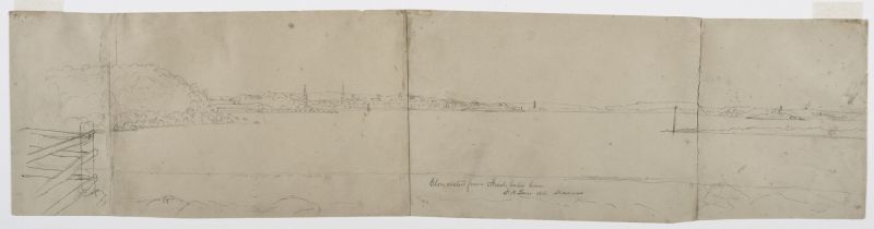
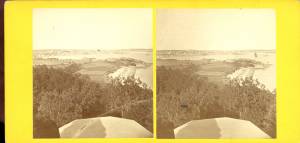
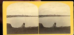
Lane often sketched and painted the landscape around Brookbank, the home of Samuel Sawyer. In this drawing, Lane has used four pieces of paper in order to capture the panoramic view of Gloucester Harbor. Similar to the painting View of Gloucester from "Brookbank," the Sawyer Homestead, c.1856 (inv. 95), the composition includes Ten Pound Island, the town of Gloucester, the Fort, and Stage Rocks. In this drawing, Lane has included the fence to his left, which provides an interesting contrast between the foreground and distant town. Two noteworthy but easily overlooked elements of this drawing are the beacon pole on the flat end of Dolliver's Neck (to the right) and the flagpole on top of the hill at the entrance to Freshwater Cove. The distinctive pointed dormers of Lane's own house appear above the Fort in the distance. It is hard to determine what is represented by the smokestack to the right; it is most likely Burnham's planing mill, which is shown on an 1851 map.
- Subject Types
: - Cape Ann Locales
: - Objects
:
Historical Materials
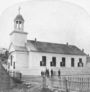
The old Baptist church appears in several Lane works. This was the first of three Baptist churches built on Pleasant Street. Baptists had been meeting on Cape Ann since 1808, originally in Sandy Bay (Rockport). But in 1830, a small group of Gloucester Baptists raised the funds to build a simple, unornamented, steeple-less white wooden building and chose this site near Franklin Square. Lane lithographs and paintings document the history of the building. In 1836, he showed it without a steeple. The building was improved in 1837 with the addition of a choir and the steeple, as seen in Lane's 1844 painting.
The building was not a church at the time of the painting of Gloucester Harbor in 1852, where it can be seen between the square four-spiked steeple of the First Parish Church and the mast of the closest, central boat. The Baptists, having recently built the large Italianate church seen just to the right in that 1852 painting, had sold the old Baptist church to Benjamin S. Corliss and other neighbors in 1850. Then in 1855, the Catholic community of Gloucester bought and moved the old church building around the corner to Prospect Street. The first Catholic mass had been held in 1849, in a private home, although the town hall was also available for masses. By 1855, the Catholic community established St. Ann's Parish, first in the old Baptist building (once again without a steeple, probably lost during the move from Pleasant Street), and then, when the current large stone church was built in 1876, this building became a school. It was replaced by the still-standing brick St. Ann's Parochial School in 1913.
– Sarah Dunlap (August, 2013)
Newspaper clipping
Cape Ann Advertiser
Collection of Fred and Stephanie Buck
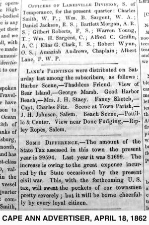
"LANE'S PAINTINGS were distributed on Saturday last among the subscribers, as follows: Harbor Scene, – Thaddeus Friend. View of Bear Island, – George Marsh. Good Harbor Beach, – Mrs. J. H. Stacy. Fancy Sketch, – Capt. Charles Fitz. Scene at Town Parish, – J. H. Johnson, Salem. Beach Scene, – Pattillo & Center. View near Done Fudging, – Ripley Ropes, Salem."
Also filed under: Alex Patillo Dry Goods » // Center & Co. » // Center, Henry » // Done Fudging » // Fitz, Capt. Charles » // Friend, Thaddeus » // Johnson, J. H. » // Marsh, George » // Newspaper / Journal Articles » // Patillo, Alex » // Ropes, Ripley » // Stacy, Mr. and Mrs. John Hancock »

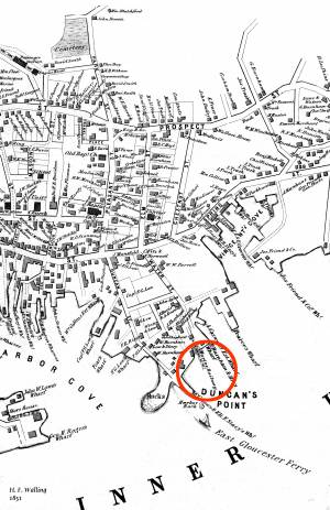
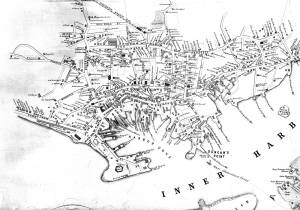
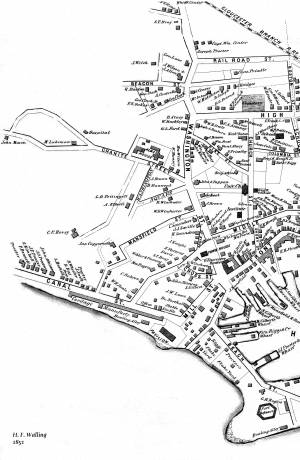
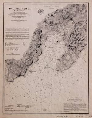
1851 44 x 34 in. Henry Francis Walling, Map of the Towns of Gloucester and Rockport, Essex Co. Massachusetts. Philadelphia, A. Kollner, 1851 Cape Ann Museum Library & Archive
"Map of the Towns of Gloucester and Rockport, Massachusetts. H.F. Walling, Civil Engineer. John Hanson, Printer. 1851. Population of Gloucester in 1850 7,805. Population of Rockport in 1850 3,213."
Also filed under: Burnham Brothers Marine Railway » // Duncan's Point » // Five Pound Island » // Flake Yard » // Gloucester Harbor, Inner / Harbor Cove » // Harbor Methodist Church (Prospect Street) » // Low (Frederick G.) wharves » // Pavilion Hotel » // Procter Brothers » // Ropewalk » // Vincent's Cove » // Western Shore »
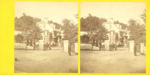
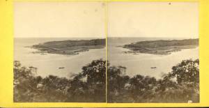
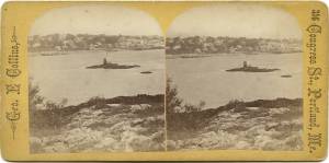
Brookbank was an early eighteenth-century white gambrel-roofed house on Fresh Water Cove which was owned and occupied by Samuel Sawyer and his ancestors. It is possible to trace apparent renovations to the house through Lane's pictures; at first it is depicted as a white house without dormers and a simple brown barn Fresh Water Cove, Gloucester, c.1864 (inv. 112); then dormers appear on the house and the barn is white with a cupola Fresh Water Cove, etc., from Dolliver's Neck, 1850s (inv. 113). In Gloucester from Brookbank, 1848 (inv. 42) a cobb wharf (log cabin-like structure) and boardwalk are visible. By Fresh Water Cove from Dolliver's Neck, Gloucester, Early 1850s (inv. 45) the house seems to have additions.
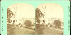
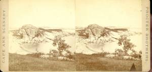
Stereograph card Cape Ann Museum Library & Archive
Stereo view of Brookbank guest house or boathouse.
Also filed under: Historic Photographs »
Published by Frank Rowell Cape Ann Museum Library & Archive
Stereograph card
Also filed under: Historic Photographs »
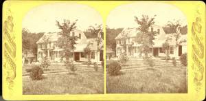
n.d. Stereographic card Cape Ann Museum Library & Archive
Penciled on reverse: "Mansion House, Brook Bank [sic], Sam'l Sawyer now Hammond, Freshwater Cove"
Also filed under: Historic Photographs » // Sawyer, Samuel »

44 x 34 in.
Henry Francis Walling, Map of the Towns of Gloucester and Rockport, Essex Co. Massachusetts. Philadelphia, A. Kollner, 1851
Cape Ann Museum Library & Archive
"Map of the Towns of Gloucester and Rockport, Massachusetts. H.F. Walling, Civil Engineer. John Hanson, Publisher. 1851. Population of Gloucester in 1850: 7,805. Population of Rockport in 1850: 3,213."
Also filed under: Annisquam River » // Dolliver's Neck » // Fresh Water Cove » // Gloucester Harbor, Outer » // Maps » // Norman's Woe » // Stage Rocks / Stage Fort / Stage Head » // Steepbank » // West Gloucester – Little River » // Western Shore »
Samuel Sawyer Papers
Cape Ann Museum Library & Archives
Archive Collection
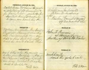
"August 25. Called to see Mr. Lane to make a sketch of old Homestead for Haughtons."
Also filed under: Diaries / Ledgers / Etc. » // Haughton, James » // Sawyer, Samuel »
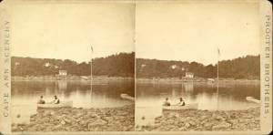
1860s Stereograph card Cape Ann Museum Library & Archive
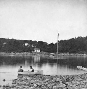
A view of a Cove on the western side of Gloucester Harbor, with the landing at Brookbank. Houses are seen in the woods back. A boat with two men is in the foreground.
Also filed under: American ensign / flag » // Fresh Water Cove » // Historic Photographs »
Stereograph card
Cape Ann Museum Library & Archive
Also filed under: Fresh Water Cove »
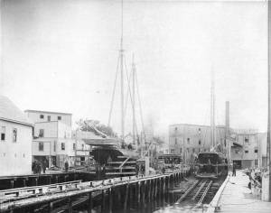
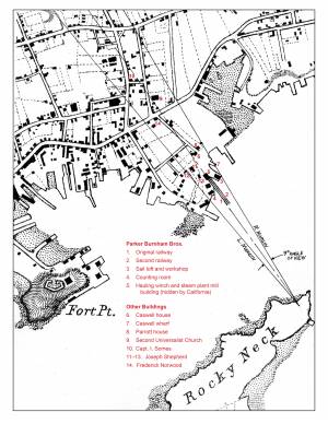
Lane was commissioned by his neighbor John Trask to paint a sign for his shop at the Burnham Brothers' Marine Railway, as seen in Three Master on the Gloucester Railways, 1857 (inv. 29). The railway, built in 1849-50, was a vital component of the ship building and repair trade, allowing large ships to be hauled out of the water to repair and clean the hulls. Originally there was just one railway, but a second was added due to increased demand. It consisted of a heavily reinforced timber structure anchored with iron spikes and topped with pairs of iron rails fitted with cast iron rollers. The vessel was hauled onto a wood cradle using a steam-powered winch, where it remained, blocked to prevent movement, for the duration of the repairs. Upgrades to the steam power plant can be observed when comparing the height of the smokestack in the painting with that in the later print View of Gloucester, 1859 (inv. 446). This may also be visible in drawings such as Gloucester from Fresh Water Cove, 1850s (inv. 144). Burnham’s was probably up-dating its steam power plant, not just to run power saws, but to power the steam winch which pulled the cradle with a ship on it up the rails.
Gloucester City Archives, Valuations for Harbor Parish, East Ward, 1851, 1852, 1853, 1854.
Valuations for wharf facilities and railway, 1851: $3,280; 1852: $4,800; 1853: $6,000; 1854: $9,000.
This steady and substantial growth is hard to explain in any other way than in the form of mechanical improvements, including steam-powered machinery to operate the hauling winch and power saws for a mill building for shipbuilding timber and planking. A note in the 1853 valuation, simply stating “new railway”, probably refers to the addition of a second railway, which would account for the significantly higher valuation in 1854.
Erik Ronnberg
Mounted print
8 x 10 in.
Cape Ann Museum Library & Archive
Railway at the tip of Duncan's Point. Vessels on the ways are "Isabell Leighton" and "Hattie B. West."
Also filed under: Duncan's Point »
Wood, cordage, acrylic paste, metal
~40 in. x 30 in.
Erik Ronnberg
Model shows mast of fishing vessel being unstepped.
Also filed under: Fishing » // Schooner (Fishing) »
1851 44 x 34 in. Henry Francis Walling, Map of the Towns of Gloucester and Rockport, Essex Co. Massachusetts. Philadelphia, A. Kollner, 1851 Cape Ann Museum Library & Archive
"Map of the Towns of Gloucester and Rockport, Massachusetts. H.F. Walling, Civil Engineer. John Hanson, Printer. 1851. Population of Gloucester in 1850 7,805. Population of Rockport in 1850 3,213."
Also filed under: Baptist Church (Old, First, 1830) (Pleasant Street) » // Duncan's Point » // Five Pound Island » // Flake Yard » // Gloucester Harbor, Inner / Harbor Cove » // Harbor Methodist Church (Prospect Street) » // Low (Frederick G.) wharves » // Pavilion Hotel » // Procter Brothers » // Ropewalk » // Vincent's Cove » // Western Shore »
Newsprint
From bound volume owned by publisher Francis Procter
Collection of Fred and Stephanie Buck
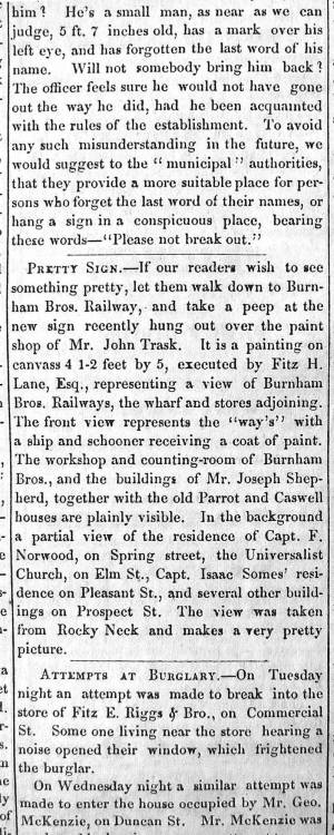
“PRETTY SIGN. – If our readers wish to see something pretty, let them walk down to Burnham Bros. Railway, and take a peep at the new sign recently hung out over the paint shop of Mr. John Trask. It is a painting on canvass 4 1-2 feet by 5, executed by Fitz H. Lane, Esq., representing a view of Burnham Bros. Railways, the wharf and stores adjoining. The front view represents the ‘way’s’ with a ship and schooner receiving a coat of paint. The workshop and counting-room of Burnham Bros., and the buildings of Mr. Joseph Shepherd, together with the old Parrot and Caswell houses are plainly visible. In the background a partial view of the residence of Capt. F. Norwood, on Spring street, the Universalist Church, on Elm St., Capt. Isaac Somes’ residence on Pleasant St., and several other buildings on Prospect St. The view was taken from Rocky Neck and makes a very pretty picture.”
Also filed under: Chronology » // John Trask Paint Store » // Newspaper / Journal Articles » // Trask, John »
Newspaper
Fire in the steam planing mill of Parker Burnham & Bros, foot of Water St. It spread through the block that included Ignatius Winter's sash-and-blind factory and John Trask's paint shop.
Also filed under: Newspaper / Journal Articles » // Trask, John » // Winter, Ignatius »

1865 41 x 29 inches Courtesy of the Massachusetts Archives Maps and Plans, Third Series Maps, v.66:p.1, no. 2352, SC1/series 50X
.
Also filed under: Collins's, William (estate wharf) » // Gloucester Harbor, Inner / Harbor Cove » // Maps » // Rogers's (George H.) wharves »
Newspaper obituary
Obituary of Parker Burnham, Esq.
Sawyer Free Library
Parker Burnham, Esq., the alderman from Ward 5, died at his residence on Spring Street on Thursday morning, of neuralgia of the heart, after a few days’ illness. Mr. Burnham was a native of Essex, son of the venerable Parker Burnham, recently deceased, but settled in Gloucester when quite a young man, and has been closely identified with the business interests of the town and city. On his removal to Gloucester, in connection with his brothers, Joseph B. and Elias, he established a shipyard, and the firm, under the name of Burnham Brothers, were successfully engaged in the building and repairing of vessels. Subsequently they built the first marine railways ever constructed in Gloucester, and in the business connected therewith Mr. Burnham remained to the time of his death. He was a man of marked character, honest in his dealings, kindly in his intercourse with his fellows, correct in his deportment and unassuming in his manners, devoting himself to his business without stepping aside to seek notoriety or distinction from his fellow citizens. In religion he was a Universalist and a regular attendant upon the services of the Independent Christian Church. In politics he was a Republican from the earliest formation of the party, and fully in accord with its principles, although he was elected upon the Board of Aldermen upon a democratic nomination, unsought, by a large majority. Since the organization of the city government Mr. Burnham has devoted a large portion of his time to the interests of the city, being constant in his attendance upon the meetings of the board and taking an active part in its deliberations. As chairman of the joint standing committee upon public property he had the oversight upon the Collins School House and the investigations concerning the remodeling of the City Hall; he was also a member of the committees upon finance and highways. His loss will be deeply felt by his associates in the city council, and by the community generally. His funeral took place on Saturday afternoon, and was attended by the members of the city council in a body.
Newspaper obituary
Obituary of Elias Burnham
Sawyer Free Library
Mr. Elias Burnham, whose severe illness was alluded to in our last issue, died at eleven o’clock on Saturday morning, having been unconscious for several hours before his death. He had been in his usual health until within a little over a week before his departure, when he was taken with an ill turn at the camp of his son, Mr. Elias P. Burnham, at West Gloucester, and grew rapidly worse until the end. Mr. Burnham was a native of Essex, being a son of Parker Burnham of that town. He was a ship carpenter by trade, and came to Gloucester over forty years ago with his brothers Parker and Joseph B., and engaged in the vessel building business on Pearce’s wharf, under the name of Burnham Brothers. Subsequently the firm purchased the Hough wharf, now owned by Walen & Son, and on the flats adjoining built the first marine railway ever constructed in Gloucester. To this business they afterwards added a planing mill, doing an extensive business. Mr. Joseph B. Burnham withdrew from the firm several years ago, carrying on for several years a planing mill on Pearce Street, and Mr. Parker Burnham, the oldest of the brothers, died in 1874, the firm of late years consisting of Elias, Elias P., son of Elias, and Parker H. and Enoch, sons of Parker. Identified for nearly half a century with the business interests of Gloucester, Mr. Burnham won a high place in the regard of his fellow citizens by his industrious habits, by the promptness and honesty which characterized all his business transactions, by his kindly social nature, his unassuming manners, and his respect for the rights and opinions of others. He was a prominent member of and liberal contributor to the support of the First Baptist Church, and his loss will be deeply felt by the members of that communion. He leaves a widow, son and daughter. His funeral took place from his late residence on Elm Street on Wednesday afternoon, his pastor, Rev. Dr. Morris officiating, and was largely attended.
Newspaper obituary
Obituary of Joseph Burnham, Esq.
Sawyer Free Library
Mr. Joseph Burnham, for many years a well known resident of this city, died very suddenly at his residence in West Gloucester on Tuesday, of paralysis, in the 67th year of his age. Although in somewhat feeble health of late years, he was able to keep about, and was out of doors the evening before his death. He was a son of Parker Burnham of Essex, and was formerly a member of the firm of Burnham Brothers (Parker, Joseph B. and Elias), who commenced ship- building in this city some two score years and more ago, and afterwards built the first marine railway in Gloucester and established a planing mill. Subsequently he retired from the firm and carried on a planing mill on Pearce Street for a number of years. He was also engaged in the remeasurement of our fishing fleet when the new tonnage law went into effect. Later, he purchased a farm in Rowley, but after a short residence there returned to Gloucester and took up his permanent residence at his summer camp at West Gloucester, where his death occurred.
He was an ingenious mechanic, steady, honest and industrious, and his sudden death will be deeply deplored by a large circle of friends. Mr. Burnham was a veteran Odd Fellow, having long been a member of Ocean Lodge, and was one of the seven charter members of Cape Ann Encampment, from which he withdrew about five years ago. His death is the second among the seven charter members of the Encampment, Capt. Edward Staten having been the first to depart from the earth life. The funeral of the deceased took place yesterday afternoon, Rev. Wm. H. Rider officiating, and was attended by the brethren of Ocean Lodge.

Detail views: marine railway and hauling cradle for vessel Wood rails, metal rollers, chain; wood cradle. Scale: ½" = 1' (1:24) Original diorama components made, 1892; replacements made, 1993. Cape Ann Museum, from Gloucester Chamber of Commerce, 1925 (2014.071)
A schooner is shown hauled out on a cradle which travels over racks of rollers on a wood and metal track.
Also filed under: Marine Railways » // Schooner (Coasting / Lumber / Topsail / Packet / Marsh Hay) »
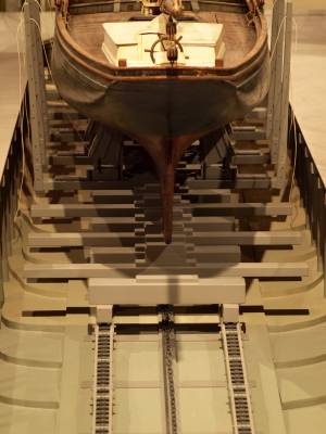
Wood rails, metal rollers, chain; wood cradle. Scale: ½" = 1' (1:24)
Original diorama components made, 1892; replacements made, 1993.
Cape Ann Museum, from Gloucester Chamber of Commerce, 1925 (2014.071)
Close up showing detail of rollers and hauling chain.
Also filed under: Marine Railways »
44 x 34 in.
John Hanson, Publisher
Cape Ann Museum Library & Archive
Also filed under: Marine Railways »
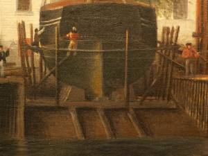
Oil on canvas
39 1/4 x 59 1/4 in.
Detail showing construction of marine railway. Details of the rollers and chain are obscured due to past cleaning efforts.
Also filed under: Marine Railways »
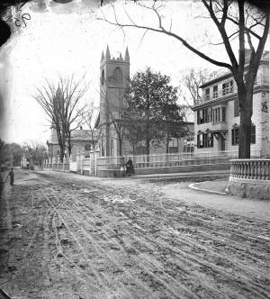
The Trinity Congregational Church, visible in Lane paintings such as Gloucester Harbor, 1852 (inv. 38), was built in 1831, during the time of the reconstruction of downtown Gloucester after the devastating 1830 fire. But this church was not built to replace one lost in that conflagration. It was built to house a large faction of the original First Parish Church (the four -pointed square tower visible in several paintings, just to the east on Middle Street) that was dismayed by the Unitarian drift of the parish. The rise of Unitarianism, and the hiring of new ministers with that leaning, caused those who continued to embrace the older Puritan, Calvinist, Congregational beliefs to secede and form their own church. It was a split between the more radical, newer element of the Unitarians and those who wished to maintain their older, Trinitarian roots.
The minister of the Trinitarian church in 1852 was James Aiken, who did not stay in town long. Nor did the building serve long as a church. In 1854, the building was sold, cut in half, and moved. Both halves now stand on Mason Street, facing south, across School Street from the Central Fire Station.
A second Trinity Congregational Church, with a steeple higher than any other in town, was immediately erected on same site in 1854. This 153-foot, octagonal steeple, visible in Gloucester from Steepbank, c.1855 (inv. 125) was removed in 1865. The church building was totally destroyed by fire in July 1979. A third church stands on the site today.
Current address: 70 Middle Street at the corner of School Street. However, the building that appears in pre-1854 Lane works was cut in half and moved to 2–8 Mason Street.
– Sarah Dunlap (August, 2013)
On Middle St., the building of the new Orthodox Church will soon be commenced. …we understand that the church when completed, will be the finest in the country. It is to be surmounted by a steeple higher than any other in town, and will be a prominent land mark. The contractors, Messrs. Smith & Babson, are young and enterprising mechanics, and will spare no pains to render the completion of the edifice as perfect and handsome as can be accomplished. The old church having been cut in two, and moved back on Mason Street, is being fitted up, and will be made into two large double dwelling houses. Another building has also been moved into this street and is being fitted up for a dwelling house.
The Union School was built in 1823, as one of Gloucester's public district schools in 1823. It was situated on land lying between High Street (now called Prospect) and Columbia Streets near what is now the site of McPherson Park. (In the Walling map below it is in the middle of the block bordered by Church, Columbia, High, and School Streets.) While Lane went to school, the number of such district schools increased from eleven in 1804 to twenty-three by 1840. This Union School was one of them, and stood for the rest of Lane's life. The land, given by Mrs. Abigail Collins, was the southern portion of the present lot, being that portion closer to Columbia Street. In the 1860s, more land was purchased and in 1864 the Collins School was built closer to Prospect Street. The original Union School, by now called the "old Collins School House," was not torn down until after Lane’s death, when it was auctioned off and purchased by F.E. Riggs in November 1865, along with its blocking and lumber and the privy, for $1,152. John W. Lurvey, a carpenter who lived around the corner on Washington Street, was hired to prepare it for sale, and he received $16.50 for six days' work. The second Collins School, was demolished in 1947. McPherson Park, an elderly housing complex, opened in 1976 and still stands on this lot.
Address: 31 Prospect Street, known as High Street in Lane's time.
– Sarah Dunlap (May, 2014)
44 x 34 in.
Henry Francis Walling, Map of the Towns of Gloucester and Rockport, Essex Co. Massachusetts. Philadelphia, A. Kollner, 1851
Cape Ann Museum Library & Archive
"Map of the Towns of Gloucester and Rockport, Massachusetts. H.F. Walling, Civil Engineer. John Hanson, Publisher. 1851. Population of Gloucester in 1850 7,805. Population of Rockport in 1850 3,213."
Segment of Harbor Village portion of map showing Lane-Winter property on Duncan's Point.
Also filed under: Duncan's Point » // Maps » // Winter, Ignatius »
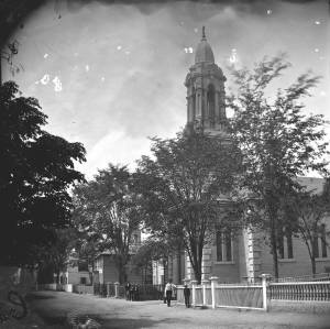
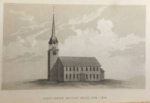
The First Parish (Unitarian) meeting house, located on Middle Street, was a wooden framed, clapboard-sheathed structure with a distinctive four-pointed neo-Gothic inspired tower. It was built in 1828, as the First Parish Church, replacing an earlier structure built on the site in 1738, when the "first" parish moved to the Harbor from its original location on the Annisquam River near where the Rte. 128 Grant Circle now is laid out. The parish system dated from the Massachusetts Bay Colony times, when both religious and civic business was conducted in the parish meetinghouses. This 1828 building was a descendant of that system. It became the Unitarian Church gradually in the 1830s, when more traditional members separated, formed their own society and built the Congregational/Trinitarian Church two doors to the west on Middle Street. The Universalists, Methodists, and Baptists had already seceded and formed their own congregations, and the parish system was at an end.
The Unitarian William Mountford, newly arrived from England, preached in this church from 1850 to 1853. In 1852, a new organ was dedicated on July 4, and Rev. Mountford was installed formally on August 3. (1) It is not known if Lane himself was a member of this or any church, but he shared several traits with Mountford: they both walked with a limp, and they were both interested in Spiritualism. Mountford moved to Boston in 1853 to pursue Transcendentalism and Spiritualism, and seldom returned to Gloucester. But he did come back in August, 1865, to officiate at Fitz Henry Lane's funeral, although Rev. Robert P. Rogers was minister at the time. It was from this church that Lane's body made its final journey to the Oak Grove Cemetery, where he was buried in the family plot of Joseph L. Stevens, Jr.
This building remained the Unitarian Church through the 1940s; however, the congregation had dwindled significantly and was no longer able to maintain the structure. The Gothic steeple was removed during this time. By 1950, the few remaining congregants were meeting with the Universalists further along Middle Street and the assets of the church were divided up: the church silver, made by Paul Revere, went to the Cape Ann Museum; endowment funds went to the Unitarian headquarters in Boston and the meeting house was sold to the local Jewish community who transformed it into Temple Ahavat Achim. Another victim of fire, it was destroyed in the conflagration that began in the next-door Lorraine Apartments on a wintry night of December, 2007.
Current Address: 86 Middle Street, site of Temple Ahavat Achim.
– Sarah Dunlap
Reference:
1. Babson, History of Gloucester, p. 497.
Watercolor on paper
Cape Ann Museum Library & Archive
Also filed under: Low (Frederick G.) wharves » // Maps »
c.1868 Glass plate negative
Also filed under: Lane's Stone House, Duncan's Point » // Residences »
Stereograph card Cape Ann Museum Library & Archive
Also filed under: Historic Photographs » // Procter Brothers »
44 x 34 in.
Henry Francis Walling, Map of the Towns of Gloucester and Rockport, Essex Co. Massachusetts. Philadelphia, A. Kollner, 1851
Cape Ann Museum Library & Archive
"Map of the Towns of Gloucester and Rockport, Massachusetts. H.F. Walling, Civil Engineer. John Hanson, Publisher. 1851. Population of Gloucester in 1850 7,805. Population of Rockport in 1850 3,213."
See p. 498. This shows the First Parish Meeting House before it was rebuilt in 1828.
Also filed under: Babson History of the Town of Gloucester »

Stereograph card
Cape Ann Museum Library & Archive
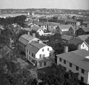
View from top of Unitarian Church on Middle Street looking southeast, showing the Fort and Ten Pound Island. Tappan Block and Main Street buildings between Center and Hancock in foreground.
Also filed under: Fort (The) and Fort Point » // Ten Pound Island »
Cape Ann Museum Library & Archive
Middle Street looking west. At the corner of Dale Avenue is the Sanders-Davidson house, later Sawyer Free Library. Also shown: Unitarian Church, Congregational Church.
Also filed under: Sanders-Davidson House »
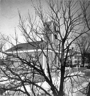
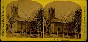
This large steepled building is Gloucester's Universalist Church. Universalism had found fertile ground here in Gloucester before the Revolution under the leadership of John Murray, who brought the teachings of James Relly from England in 1774. With adherents among the town's leaders such as Winthrop Sargent and his daughter, Judith Sargent Stevens Murray, it spread and flourished. The Gloucester adherents to Universalism refused to support quasi-governmental parish churches, specifically the First Parish in the Harbor district, and, speaking as well for all other non-parish churches, their dissent led to the Constitutional separation of Church and State. The first Universalist meetings were held on Sargent property at what was then Spring and Water Streets, now near the corner of Main and Duncan Streets. In 1805, under a new minister, Thomas Jones, this towering structure of the Universalist Church was erected by the local architect and builder, Jacob Smith.
The church's interior and foundation have been changed slightly since Lane's 1852 painting: in the 1860s, the foundation was raised seven feet to allow for a hall in the basement, and the lovely curved vestry staircases were installed. But the steeple remains as Smith, and Lane, saw it. It still houses a Paul Revere bell—for many years the only large bell in town. In 1852, this was the tallest structure on the skyline and a beacon to returning vessels. Its height was increased by the addition of a 'blind story' to the stack of belfry, lantern and cupola.
In 1852, the minister of the church was Amory D. Mayo, but in three years William R.G. Mellen would occupy the pulpit. He and his brother Charles Mellen were both Universalist ministers. Charles' wife was Mary Blood Mellen, Lane's student and copyist, but Charles was never a minister in Gloucester.
Current address: 50 Middle Street.
– Sarah Dunlap (May, 2014)
Cape Ann Museum Library & Archive
Stereo view of a front and side view of the Church, taken when there was no foliage upon the trees. Church street is also given throughout its length.
Also filed under: Historic Photographs »
1865 Stereograph card Cape Ann Museum Library & Archive
Also filed under: Historic Photographs »
44 x 34 in.
Henry Francis Walling, Map of the Towns of Gloucester and Rockport, Essex Co. Massachusetts. Philadelphia, A. Kollner, 1851
Cape Ann Museum Library & Archive
"Map of the Towns of Gloucester and Rockport, Massachusetts. H.F. Walling, Civil Engineer. John Hanson, Publisher. 1851. Population of Gloucester in 1850 7,805. Population of Rockport in 1850 3,213."

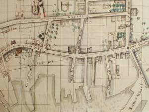
1834–35 24 x 38 in. Gloucester City Archives
"Drawn on a scale of one hundred feet to an inch. By John Mason 1834–45 from Actual Survey showing every Lott and building then standing on them giving the actual size of the buildings and width of the streets from the Canal to the head of the Harbour & part of Eastern point as farr as Smith's Cove and the Shore of the same with all the wharfs then in use. Gloucester Harbor 1834–35."
This map is especially helpful in showing the wharves of the inner harbor at the foot of Washington Street.
Also filed under: Dale, Eben B. » // Eastern Railroad » // Flake Yard » // Gloucester Harbor, Inner / Harbor Cove » // Hough, Benjamin Kent » // Maps » // Pavilion (Publick) Beach » // Ropewalk » // Sawyer, Samuel » // Town / Public Landings »

4 x 6 in.
Cape Ann Museum, Benham Collection
George Steele sail loft, William Jones spar yard, visible across harbor. Photograph is taken from high point on the Fort, overlooking business buildings on the Harbor Cove side.
Also filed under: Fort (The) and Fort Point » // Gloucester Harbor, Inner / Harbor Cove » // Town House » // Waterfront, Gloucester »
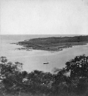
Lane did a remarkable series of paintings from Brookbank, the Sawyer homestead, which overlooks Fresh Water Cove. They show Dolliver’s Neck and how it protects the cove from the harbor. It is also visible in Dolliver's Neck and the Western Shore from Field Beach, 1857 (inv. 3), though somewhat disguised by the rest of the western shore in that view. He did a drawing and painting from Dolliver’s Neck looking west in Fresh Water Cove from Dolliver's Neck, Gloucester, Early 1850s (inv. 45).
Dolliver’s Neck is a small arm of land pointing north off the western shore of the Gloucester’s Outer Harbor. It is the cradling arm that creates Fresh Water Cove, a small cove where Samuel de Champlain found fresh water on his first visit to Gloucester Harbor in 1606. It was named for Samuel Dolliver who came from Marblehead in 1652 and bought a farm there.
In Lane’s time there were a few fishing shacks visible in some of his paintings where onshore fishermen could put their boats in from the pebble beach and salt marsh and be out in the center of the harbor without the long row or sail from the Inner Harbor. Fresh Water Cove itself is not deep enough at low tide for larger vessels to moor there so it has retained its small scale and intimate feel down through the years.
In 1900 a Coast Guard lifesaving station was built and manned on Dolliver’s Neck and many lives were saved along that rocky and treacherous coast between Gloucester and Magnolia.
Newsprint
From bound volume owned by publisher Francis Procter
Collection of Fred and Stephanie Buck
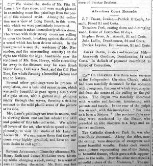
"We visited the studio of Mr. Fitz H. Lane a few days since, and were much pleased in examining some fine paintings from the pencil of this talented artist. Among the collection was a view of Long Beach, in this town, with which we were particularly interested.
The scene is taken immediately after a storm. The waves with their snowy crests are rolling in upon the beach, breaking against the sides of a vessel which has been driven ashore. In the background is seen the residence of Mr. Fessenden, and the surrounding scenery; on the right are visible the high headlands near the residence of Mr. Geo. Hovey, while stretching far away in the distance may be seen Fresh Water Cove, Dolliver's Neck, and the Old Pine Tree, the whole forming a beautiful picture and true to Nature.
Several other paintings were in process of completion, one a beautiful sunset scene, which was really beautiful to gaze upon; also a view of a gale at sea, with a gallant ship plunging madly through the waves, forming a striking contrast to the mild placid scene of the picture at its side.
Mr. Lane's paintings are true to nature, and in viewing them one can but admire the skill and genius of this talented artist, We advise all lovers of the art, who wish to spend an hour pleasantly, to visit the studio of Mr. Lane on Locust St. We can assure them that they will come away highly gratified, and have an earnest desire to call again." (1)
(1) See p. 2, column 3, Courtesy of the American Antiquarian Society
Also filed under: Chronology » // Fessenden, C. B. » // Fresh Water Cove » // Lone Pine » // Newspaper / Journal Articles » // Steepbank » // Studio Descriptions »
44 x 34 in.
Henry Francis Walling, Map of the Towns of Gloucester and Rockport, Essex Co. Massachusetts. Philadelphia, A. Kollner, 1851
Cape Ann Museum Library & Archive
"Map of the Towns of Gloucester and Rockport, Massachusetts. H.F. Walling, Civil Engineer. John Hanson, Publisher. 1851. Population of Gloucester in 1850: 7,805. Population of Rockport in 1850: 3,213."
Also filed under: Annisquam River » // Brookbank » // Fresh Water Cove » // Gloucester Harbor, Outer » // Maps » // Norman's Woe » // Stage Rocks / Stage Fort / Stage Head » // Steepbank » // West Gloucester – Little River » // Western Shore »

Engraving of 1819 survey taken from American Coast Pilot 14th edition
9 1/2 x 8 in.
Cape Ann Museum Library & Archive
D32 FF5
Also filed under: Eastern Point » // Maps » // Norman's Woe » // Ten Pound Island »
Newspaper
"Mr. Lane has just completed a third picture of the Western Shore of Gloucester Harbor, including the distance from 'Norman's Woe Rock' to 'Half Moon Beach.' It was painted for Mr. William E. Coffin of Boston, and will be on exhibition at the artist's rooms for only a few days; we advise all our readers who admire works of art, and would see one of the best pictures Mr. Lane has ever executed..."
"...solitary pine, so many years a familiar object and landmark to the fisherman."
c.1860 Stereograph card Cape Ann Museum Library & Archive
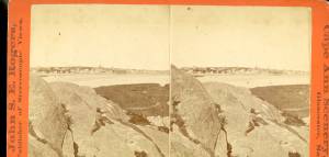
Taken from Steepbank, on the western side of Gloucester Harbor, and showing a small boat at anchor in the cove, then the Neck, and the sea beyond.
Also filed under: Fresh Water Cove » // Historic Photographs » // Lone Pine » // Steepbank »
1860s Stereograph card Cape Ann Museum Library & Archive
"Cape Ann Scenery, John S. E. Rogers, Low's Block. #54 Dolliver's Neck. Taken from Steepbank, on the western side of Gloucester Harbor, and showing a small boat at anchor in the cove, then the Neck and the sea beyond."
Also filed under: Historic Photographs »
4 x 5 in.
Cape Ann Museum Library & Archive
Freshwater Cove and Dolliver's Neck from the water off Stage Fort.
Also filed under: Fresh Water Cove »
The owner of this flagpole has not been determined, but it is an interesting landmark in Lane's paintings. Often it appears in his drawings and not in his paintings, and Western Shore of Gloucester Outer Harbor, 1857 (inv. 107) contains the only image of a flag actually flying from the pole.
Through the years, this point and its fortifications had many names: Watch House Point, the Old Battery, Fort Defiance, Fort Head, and now just "The Fort." In 1793, Fort Defiance was turned over to the young United States government and was allowed to deteriorate. During the War of 1812 it was described as being "in ruins," and any remaining buildings burned in 1833. It was resuscitated in the Civil War and two batteries of guns were installed. The City of Gloucester did not regain ownership of the land until 1925.
The first fortifications on this point, guarding the entrance to the Inner Harbor, were put up in the 1740s, when fear of attack from the French led to the construction of a battery armed with twelve-pounder guns. Greater breastworks were thrown up in 1775, after Capt. Lindsay and his sloop-of-war the "Falcon" attacked the unprepared town. They were small and housed only a few cannon and local soldiers. Several other fortifications were at various times erected around the harbor: Fort Conant at what is now Stage Fort Park, another on Duncan's Point (near site of Lane's house) and the Civil War fort on Eastern Point. None of these preparations was ever called upon to actually defend the town.
Lane during his lifetime created a long series of images of the point and the condition of its fortifications. In 1832 there were still buildings standing, and the point had not yet been used for major wharves and warehouses. By the time of his painting Gloucester Harbor, 1852 (inv. 38), one can see that the earthwork foundation, but no superstructures, survived.
– Sarah Dunlap

1860 In John J. Babson, History of the Town Gloucester (Gloucester, MA: Procter Brothers, 1860) Cape Ann Museum Library & Archives, Gloucester, Mass.
See p. 474.
View related catalogue entries (4) »
Also filed under: Babson History of the Town of Gloucester » // Chebacco Boat / Dogbody / Pinky » // Gloucester Harbor, Inner / Harbor Cove » // Gloucester, Mass. - "Ten Pound Island Light » // Schooner (Coasting / Lumber / Topsail / Packet / Marsh Hay) » // Ten Pound Island »
Newsprint
Gloucester Telegraph
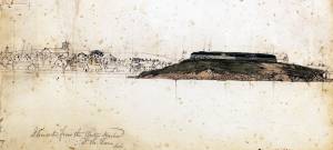
About picture of Old Fort hanging in the Gloucester Bank: "This picture is chiefly of interest on account of its preserving so accurately the features of a view so familiar to many of our citizens and which can never exist in reality."
Also filed under: Chronology » // Gloucester Bank » // Gloucester, Mass. – Gloucester Bank » // Newspaper / Journal Articles »

24 x 38 in.
Gloucester City Archives
"Drawn on a scale of one hundred feet to an inch. By John Mason 1834–45 from Actual Survey showing every Lott and building then standing on them giving the actual size of the buildings and width of the streets from the Canal to the head of the Harbour & part of Eastern point as farr as Smith's Cove and the Shore of the same with all the wharfs then in use. Gloucester Harbor 1834–35."
This map is especially useful in showing the Fort.
Also filed under: Flake Yard » // Maps » // Mason, John » // Pavilion (Publick) Beach » // Town / Public Landings »

44 x 34 in.
John Hanson, Publisher
Cape Ann Museum Library & Archive
"Map of the Towns of Gloucester and Rockport, Massachusetts. H.F. Walling, Civil Engineer. John Hanson, Publisher. 1851. Population of Gloucester in 1850 7,805. Population of Rockport in 1850 3,213."
Also filed under: Low (Frederick G.) wharves » // Maps » // Rogers's (George H.) wharves » // Town / Public Landings » // Waterfront, Gloucester » // Windmill »
Newsprint
Cape Ann Advertiser
Cape Ann Museum Library & Archive
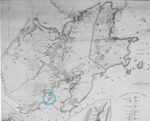
"Fort Hill was occupied by Capt. H. C. Mackay and John Lowe, as a flake-yard, and there were but one or two old fish-houses in the vicinity. The improvements at this point during the last fifteen years have left no traces of its former appearance, almost every landmark having been obliterated. A very good idea of the place as it then appeared may be obtained from the painting of Fitz H. Lane, Esq., now on exhibition at the Reading Room under the Gloucester Bank."
Also filed under: Gloucester Bank » // Newspaper / Journal Articles »
Newspaper
Gloucester Telegraph
"By the will of the late Fitz H. Lane, Esq., his handsome painting of the Old Fort, Ten Pound Island, etc., now on exhibition at the rooms of the Gloucester Maritime Insurance Co., was given to the town... It will occupy its present position until the town has a suitable place to receive it."
Also filed under: Funeral & Burial » // Gloucester, Mass. – Marine Insurance Company » // Newspaper / Journal Articles » // Ten Pound Island »
Newsprint
Gloucester Telegraph
At the dedication of the Town House, speaker, "read the following letter:
To the Selectmen of Gloucester: / Gents: The will of our late Townsman, Fitz. H. Lane, contains this provision: / I give to the inhabitants of the Town of Gloucester, the picture of the Old Fort, to be kept as a memento[sic] of one of the localities of olden time; the said picture now hanging in the Reading Room under the Gloucester Bank, and to be there kept until the Town of Gloucester shall furnish a suitable and safe place to hang it. / The original sketch was taken twenty-five years ago, but the boats and vessels introduced are those of a quarter of a century earlier still. The painting was executed in 1859, six years before his decease."
Also filed under: Documents / Objects » // Newspaper / Journal Articles » // Town House »
Stereograph card
Cape Ann Museum Library & Archive
View from top of Unitarian Church on Middle Street looking southeast, showing the Fort and Ten Pound Island. Tappan Block and Main Street buildings between Center and Hancock in foreground.
Also filed under: Ten Pound Island » // Unitarian Church / First Parish Church (Middle Street) »

1876 Photograph Cape Ann Museum Library & Archive
Ignatius Weber's windmill (now defunct) is shown.
Also filed under: Flake Yard » // Gloucester Harbor, Inner / Harbor Cove » // Historic Photographs » // Rogers's (George H.) wharves » // Schooner (Fishing) » // Waterfront, Gloucester » // Windmill »
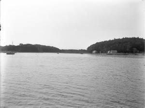
Gloucester Outer Harbor served as a staging area for deep draft or heavily laden vessels waiting to come into the wharves in the shallow Old Harbor at high tide, or waiting to discharge cargo into smaller vessels. While Lane's paintings typically show one or two vessels in the harbor, works by other artists from the period, as well as contemporary descriptions, demonstrate that the harbor was usually crowded with vessels, especially in bad weather. The Outer Harbor could accommodate as many as three hundred vessels when they needed to shelter during a storm.
There were two deep spots where they could wait, the "Deep Hole" between Ten Pound Island and the Fort; and the "Pancake Grounds" between Ten Pound Island and Eastern Point. The "Pancake Grounds" also served as a quarantine area for ships arriving from foreign ports. "Deep Hole" was named for the (relatively) deep water between Rocky Neck and Fort Point to the Outer Harbor. Deeply loaded vessels had to anchor there for “lightering” (partial unloading by boats called “lighters”) prior to final unloading at wharfside. "Deep Hole" was 20–25 feet deep at low tide, when Harbor Cove was only 1–6 feet deep with bare ground around some wharves. "Deep Hole" is where you see ships anchored in Gloucester Harbor from Rocky Neck, 1844 (inv. 14), The Old Fort and Ten Pound Island, Gloucester, 1850s (inv. 30), , Gloucester Inner Harbor, 1850 (inv. 240), The Fort and Ten Pound Island, Gloucester, Massachusetts, 1847 (inv. 271), and Gloucester Harbor, 1848 (inv. 335) (which is coming to anchor).
The term "Deep Hole" is apparently a post-Bellum term. Prior to that, it was known as "The Stream" and, as later, served as anchorage where deeply loaded vessels could be lightered prior to docking in Harbor Cove. Alfred Mansfield Brooks in his book Gloucester Recollected uses this term on page 53. After the Civil War, merchant shipping in Gloucester was dominated by salt ships and later coal carriers, bringing a whole new culture to the harbor, and with it new names for old places.

John Heywood Photo for Hervey Friend
Cape Ann Museum Library & Archive (2013.068)
Schooners anchored on the Pancake Ground, taken from from Wonson's Cove, easterly side of the Rocky Neck causeway. Eastern Point Fort and garrison in background to far left.
Also filed under: Eastern Point »

c.1870 Stereograph card Procter Brothers, Publisher Cape Ann Museum Library & Archive
"Gloucester Harbor from Rocky Neck, Looking Southwest. This gives a portion of the Harbor lying between Ten Pound Island and Eastern Point. At the time of taking this picture the wind was from the northeast, and a large fleet of fishing and other vessels were in the harbor. In the range of the picture about one hundred vessels were at anchor. In the small Cove in the foreground quite a number of dories are moored. Eastern Point appears on the left in the background."
Southeast Harbor was known for being a safe harbor.
Also filed under: Historic Photographs » // Rocky Neck » // Schooner (Fishing) » // Small Craft – Wherries, and Dories »

Collection of Erik Ronnberg
View related catalogue entries (2) »
Also filed under: Dolliver's Neck » // Fresh Water Cove » // Gloucester Harbor, Inner / Harbor Cove » // Maps »

c.1870 Stereograph card Procter Brothers, Publisher Cape Ann Museum Library & Archive
View from Civil War fort on Eastern Point.
Also filed under: Eastern Point » // Historic Photographs »

44 x 34 in.
Henry Francis Walling, Map of the Towns of Gloucester and Rockport, Essex Co. Massachusetts. Philadelphia, A. Kollner, 1851
Cape Ann Museum Library & Archive
"Map of the Towns of Gloucester and Rockport, Massachusetts. H.F. Walling, Civil Engineer. John Hanson, Publisher. 1851. Population of Gloucester in 1850: 7,805. Population of Rockport in 1850: 3,213."
Also filed under: Annisquam River » // Brookbank » // Dolliver's Neck » // Fresh Water Cove » // Maps » // Norman's Woe » // Stage Rocks / Stage Fort / Stage Head » // Steepbank » // West Gloucester – Little River » // Western Shore »
Newsprint
Cape Ann Advertiser
Cape Ann Museum Library & Archive
Notice in the Cape Ann Advertiser announcing arrival of ships into the port of Gloucester, with details of their cargo.
Also filed under: Newspaper / Journal Articles » // Trade Routes and Statistics »
Newspaper
"Lane's studio seldom presents so many attractions to visitors as at the present time. With unwonted rapidity his easel has turned off pictures in answer to the numerous orders which have poured in from all quarters."
Also filed under: Chronology » // Newspaper / Journal Articles » // Studio Descriptions »
Electrotype impression
Collection of Erik Ronnberg
Also filed under: Gloucester Harbor, Inner / Harbor Cove » // Maps »

c.1870 Stereograph card Procter Brothers, Publisher Cape Ann Museum Library & Archive
Also filed under: Historic Photographs » // Stage Rocks / Stage Fort / Stage Head »

Pencil and ink on paper
15 x 22 1/8 in.
Cape Ann Museum, Gloucester, Mass., Gift of Mr. Donald K. Usher, in memory of Mrs. Margaret Campbell Usher, 1984 (2401.19)
Also filed under: Beacons / Monuments / Spindles » // Mackerel Fishing »

Watercolor on paper
8 3/4 x 19 3/4 in.
Cape Ann Museum, Gloucester, Mass., Gift of Rev. and Mrs. A. A. Madsen, 1950
Accession # 1468
Fishing schooners in Gloucester's outer harbor, probably riding out bad weather.
Also filed under: Elwell, D. Jerome » // Schooner (Fishing) »
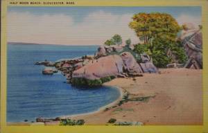
Half Moon Beach is a small crescent of sand, nestled into Stage Fort Park, between Stage Point (where the remains of a Revolutionary War earthworks fort still stands) and a large ledge outcropping that on the far side houses the tablet commemorating the original 1623 settlement of the area by the Dorchester Company. At the time Lane painted his views of the Harbor in which one can see this beach, the entire little peninsula, once known as Fisherman's Field, was probably owned by the B. K. Hough family. The area, including this beach, is now public. From the beach, one can see much of the Outer Harbor, Pavilion Beach, and Ten Pound Island.
– Sarah Dunlap (June, 2015)
c.1870 Stereograph card Cape Ann Museum Library & Archive
Also filed under: Historic Photographs » // Stage Rocks / Stage Fort / Stage Head » // Western Shore »
c.1870 Stereograph card Cape Ann Museum Library & Archive
Also filed under: Historic Photographs »
Newspaper
"Mr. Lane has just completed a third picture of the Western Shore of Gloucester Harbor, including the distance from 'Norman's Woe Rock' to 'Half Moon Beach.' It was painted for Mr. William E. Coffin of Boston, and will be on exhibition at the artist's rooms for only a few days; we advise all our readers who admire works of art, and would see one of the best pictures Mr. Lane has ever executed..."
"...solitary pine, so many years a familiar object and landmark to the fisherman."
c.1870 Stereograph card Cape Ann Museum Library & Archive
Also filed under: Gloucester – City Views » // Historic Photographs » // Stage Rocks / Stage Fort / Stage Head » // Steepbank »
29 x 25 in.
Cape Ann Museum Library & Archive (#089)
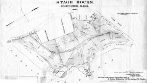
Ernest Bowditch was a landscape gardener. This map shows some of the various names of landmarks around Stage Rocks.
Also filed under: Field Beach / Crescent (or Cressy's) Beach / Long Beach » // Maps » // Stage Rocks / Stage Fort / Stage Head »
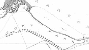
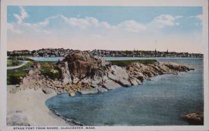
The Stage, as it was known in Lane’s time, now Stage Fort Park, rises from the western shore of the Outer Harbor, just south and west of the Cut and the Blynman Bridge as you leave Gloucester. This was the first settlement of the Massachusetts Bay Colony in 1623 where fourteen men of the Dorchester Company landed and tried in vain to settle and survive through a combination of fishing and farming. They were successful at neither, and in 1626 they moved on and founded Salem.
During the Revolution the Gloucester patriots built a fort on the north side of Half Moon Beach to defend against British invaders which was never needed. The fort was restored for the War of 1812 and again for the Civil War, but again saw no action.
During Lane’s lifetime this area was the Hough farm. Townspeople were generally given free run of the place for strolling and picnics overlooking the harbor. The enormous rounded boulders and ledge outcroppings rose dramatically from the fields above the harbor without the tree cover that partially obscures them today.
Lane did numerous paintings of this area, including many views looking westward from the vantage point onboard a boat in the harbor. In Stage Rocks and the Western Shore of Gloucester Outer Harbor, 1857 (inv. 8) the Stage Rocks frame the west side of Gloucester Harbor and provided a peaceful and bucolic counterpoint to the intense activity of the city waterfront only a mile away across the harbor. Lane also painted the Stage Rocks from the beach just to the north near the Cut and Field Beach, which is on the southern side of the Stage Rocks facing out the harbor entrance to the sea.
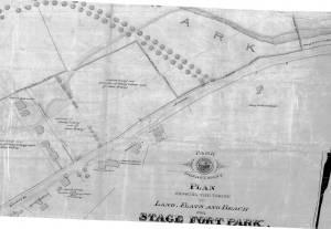
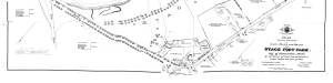
Commonwealth of Massachusetts: Southern Essex District Registry of Deeds
1543 plan 0141_0002
The third of the three plans has the references on it. "Plan showing the taking of land, flats and beach for Stage Fort Park…1898..."
Includes a reference to the home of Mary Turnbull which is Steepbank.
Also filed under: Maps » // Steepbank »
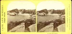
c.1870 Stereograph card Cape Ann Museum Library & Archive
Also filed under: Gloucester – City Views » // Half Moon Beach » // Historic Photographs » // Steepbank »
44 x 34 in.
Henry Francis Walling, Map of the Towns of Gloucester and Rockport, Essex Co. Massachusetts. Philadelphia, A. Kollner, 1851
Cape Ann Museum Library & Archive
"Map of the Towns of Gloucester and Rockport, Massachusetts. H.F. Walling, Civil Engineer. John Hanson, Publisher. 1851. Population of Gloucester in 1850: 7,805. Population of Rockport in 1850: 3,213."
Also filed under: Annisquam River » // Brookbank » // Dolliver's Neck » // Fresh Water Cove » // Gloucester Harbor, Outer » // Maps » // Norman's Woe » // Steepbank » // West Gloucester – Little River » // Western Shore »
c.1870 Stereograph card Cape Ann Museum Library & Archive
Also filed under: Half Moon Beach » // Historic Photographs » // Western Shore »
c.1870 Stereograph card Cape Ann Museum Library & Archive
Also filed under: Gloucester – City Views » // Historic Photographs »
c.1890 Stereograph card Cape Ann Museum Library & Archive
"In the foreground is a clear sheet of water which washes upon the beach beyond. The Pavilion is quite prominent, while upon the rising background can be seen the steeples of the several churchs, the tower of the first Town House, and the Collins School House."
Also filed under: Gloucester – City Views » // Historic Photographs » // Pavilion Hotel »
Cape Ann Museum Library & Archive
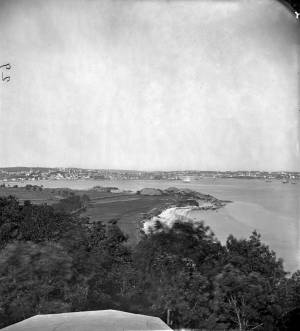
Stage Fort from Hough's Farm, showing a panorama of the harbor from Pavilion Beach to Fort Point and Rocky Neck.
Also filed under: Field Beach / Crescent (or Cressy's) Beach / Long Beach »
c.1870 Stereograph card Procter Brothers, Publisher Cape Ann Museum Library & Archive
Also filed under: Gloucester Harbor, Outer » // Historic Photographs »
Commonwealth of Massachusetts. Southern Essex District Registry of Deeds. 1543 plan 0141_0003
salemdeeds.com
The third of the three plans has the references on it “Plan showing the taking of land, flats and beach for Stage Fort Park…1898…"
Includes a reference to the home of “Mary Turnbull” which is Steepbank.
Also filed under: Maps »
Commonwealth of Massachusetts: Southern Essex District Registry of Deeds
1543 plan 0141_0001
The third of the three plans has the references on it “Plan showing the taking of land, flats and beach for Stage Fort Park…1898…”
Includes a reference to the home of Mary Turnbull which is Steepbank.
Also filed under: Field Beach / Crescent (or Cressy's) Beach / Long Beach » // Maps » // Steepbank »
Colored lithograph
Cape Ann Museum Library and Archive
Also filed under: Western Shore »
29 x 25 in.
Cape Ann Museum Library & Archive (#089)
Ernest Bowditch was a landscape gardener. This map shows some of the various names of landmarks around Stage Rocks.
Also filed under: Field Beach / Crescent (or Cressy's) Beach / Long Beach » // Half Moon Beach » // Maps »
Ten Pound Island guards the entrance to Gloucester’s Inner Harbor and provides a crucial block to heavy seas running southerly down the Outer Harbor from the open ocean beyond. The rocky island and its welcoming lighthouse is seen, passed, and possibly blessed by every mariner entering the safety of Gloucester’s Inner Harbor after outrunning a storm at sea. Ten Pound Island is situated such that the Inner Harbor is protected from open water on all sides making it one of the safest harbors in all New England.
Legend has it that the island was named for the ten pound sum paid to the Indians for the island, and the smaller Five Pound Island deeper in the Inner Harbor was purchased for that lesser sum. None of it makes much financial sense when the entirety of Cape Ann was purchased for only seven pounds from the Indian Samuel English, grandson of Masshanomett the Sagamore of Agawam in 1700. From approximately 1640 on the island was used to hold rams, and anyone putting female sheep on the island was fined. Gloucester historian Joseph Garland has posited that the name actually came from the number of sheep pens it held, or pounds as they were called, and the smaller Five Pound Island was similarly named.
The island itself is only a few acres of rock and struggling vegetation but is central to the marine life of the harbor as it defines the eastern edge of the deep channel used to turn the corner and enter the Inner Harbor. The first lighthouse was lit there in 1821, and a house was built for the keeper adjacent to the lighthouse.
In the summer of 1880 Winslow Homer boarded with the lighthouse keeper and painted some of his most masterful and evocative watercolor views of the busy harbor life swirling about the island at all times of day. Boys rowing dories, schooners tacking in and out in all weather, pleasure craft drifting in becalmed water, seen together they tell a Gloucester story of light, water and sail much as Lane’s work did only several decades earlier.

Colored lithograph
Cape Ann Museum Library and Archive
Also filed under: Gloucester, Mass. - "Ten Pound Island Light »

Photograph
From The Illustrated Coast Pilot with Sailing Directions. The Coast of New England from New York to Eastport, Maine including Bays and Harbors, N. L. Stebbins, 1891.
Also filed under: Gloucester, Mass. - "Ten Pound Island Light »


Oil on canvas
22 x 36 in.
Cape Ann Museum, Gloucester, Mass., deposited by the Collection of Addison Gilbert Hospital, 1978 (DEP. 201)
Detail of party boat.
Also filed under: Party Boat »
Engraving of 1819 survey taken from American Coast Pilot 14th edition
9 1/2 x 8 in.
Cape Ann Museum Library & Archive
D32 FF5
Also filed under: Dolliver's Neck » // Eastern Point » // Maps » // Norman's Woe »
Newspaper
Gloucester Telegraph
"By the will of the late Fitz H. Lane, Esq., his handsome painting of the Old Fort, Ten Pound Island, etc., now on exhibition at the rooms of the Gloucester Maritime Insurance Co., was given to the town... It will occupy its present position until the town has a suitable place to receive it."
Stereograph card
Cape Ann Museum Library & Archive
View from top of Unitarian Church on Middle Street looking southeast, showing the Fort and Ten Pound Island. Tappan Block and Main Street buildings between Center and Hancock in foreground.
Also filed under: Fort (The) and Fort Point » // Unitarian Church / First Parish Church (Middle Street) »
1860 In John J. Babson, History of the Town Gloucester (Gloucester, MA: Procter Brothers, 1860) Cape Ann Museum Library & Archives, Gloucester, Mass.
See p. 474.
View related catalogue entries (4) »
Also filed under: Babson History of the Town of Gloucester » // Chebacco Boat / Dogbody / Pinky » // Fort (The) and Fort Point » // Gloucester Harbor, Inner / Harbor Cove » // Gloucester, Mass. - "Ten Pound Island Light » // Schooner (Coasting / Lumber / Topsail / Packet / Marsh Hay) »
The ensign of the United States refers to the flag of the United States when used as a maritime flag to indentify nationality. As required on entering port, a vessel would fly her own ensign at the stern, but a conventional token of respect to the host country would be to fly the flag of the host country (the United States in Boston Harbor, for example) at the foremast. See The "Britannia" Entering Boston Harbor, 1848 (inv. 49) for an example of a ship doing this. The American ensign often had the stars in the canton arranged in a circle with one large star in the center; an alternative on merchant ensigns was star-shaped constellation. In times of distress a ship would fly the ensign upside down, as can be seen in Wreck of the Roma, 1846 (inv. 250).
The use of flags on vessels is different from the use of flags on land. The importance and history of the flagpole in Fresh Water Cove in Gloucester is still being studied.
The modern meaning of the flag was forged in December 1860, when Major Robert Anderson moved the U.S. garrison from Fort Moultrie to Fort Sumter in Charleston Harbor. Adam Goodheart argues this was the opening move of the American Civil War, and the flag was used throughout northern states to symbolize American nationalism and rejection of secessionism.
Before that day, the flag had served mostly as a military ensign or a convenient marking of American territory, flown from forts, embassies, and ships, and displayed on special occasions like American Independence day. But in the weeks after Major Anderson's surprising stand, it became something different. Suddenly the Stars and Stripes flew—as it does today, and especially as it did after the September 11 attacks in 2001—from houses, from storefronts, from churches; above the village greens and college quads. For the first time American flags were mass-produced rather than individually stitched and even so, manufacturers could not keep up with demand. As the long winter of 1861 turned into spring, that old flag meant something new. The abstraction of the Union cause was transfigured into a physical thing: strips of cloth that millions of people would fight for, and many thousands die for.
– Adam Goodheart, Prologue of 1861: The Civil War Awakening (2011).
1860s Stereograph card Cape Ann Museum Library & Archive
A view of a Cove on the western side of Gloucester Harbor, with the landing at Brookbank. Houses are seen in the woods back. A boat with two men is in the foreground.
Also filed under: Brookbank » // Fresh Water Cove » // Historic Photographs »
Courtesy American Antiquarian Society, Worcester, Mass. (CL.F9116.011.1854 CL.F9116.011.1854)
Also filed under: Oak Hall »
Courtesy American Antiquarian Society, Worcester, Mass. (CL.F9116.011.1854)
Also filed under: Oak Hall »
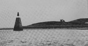
A "spindle" is a fixed marker to indicate a hazard to navigation (such as a rock which couldn't be seen at high tide). It serves the same purpose as a channel buoy, a "light beacon," or a “monument,” to warn vessels away from dangerous places or stretches of coastline. Spindles are usually iron rods with some sort of geometric object (round, flat, or triangular) on top, brightly painted (usually red) for visibility. Monuments, like the ones you see in Lane’s depictions of Half Way Rock or Norman’s Woe Reef, were made of stone and look like stumpy obelisks—or grave monuments. They were also essential as reference points for the early coastal surveys in their efforts to make more accurate charts.
In Castine, the notable square monument in the center of the harbor marked Hosmer's Ledge.
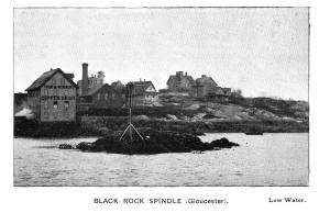
Photograph in The Illustrated Coast Pilot with Sailing Directions. The Coast of New England from New York to Eastport, Maine including Bays and Harbors, published by N. L. Stebbins, Boston
Also filed under: Gloucester Harbor, Inner / Harbor Cove »
Pencil and ink on paper
15 x 22 1/8 in.
Cape Ann Museum, Gloucester, Mass., Gift of Mr. Donald K. Usher, in memory of Mrs. Margaret Campbell Usher, 1984 (2401.19)
Also filed under: Gloucester Harbor, Outer » // Mackerel Fishing »
Stereograph card Castine Historical Society Collections (1996.1)
View related catalogue entries (2) »
Also filed under: Castine » // Historic Photographs »
The Ten Pound Island light was built on a three-and-a-half acre island at the eastern end of Gloucester Harbor. Built as a conical stone tower, the original 20-foot-tall Ten Pound Island Light was first lit in October, 1821 after the Commonwealth of Massachusetts and the Town of Gloucester ceded 1.7 acres to the U.S. Government for the construction of an inner harbor lighthouse to help mariners navigate the harbor. Ten Pound Island light was a popular subject with artists, including Winslow Homer, who boarded with the lighthouse keeper at Ten Pound Island in the summer of 1880. It is frequently featured in Lane's paintings of Gloucester Harbor.
This information has been shared with the Lane project by Jeremy D'Entremont. More information can be found at his website, www.newenglandlighthouses.net or in The Lighthouse Handbook New England. This information has also been summarized from Paul St. Germain's book, Lighthouses and Lifesaving Stations on Cape Ann.

Colored lithograph
Cape Ann Museum Library and Archive
Also filed under: Ten Pound Island »
Photograph
From The Illustrated Coast Pilot with Sailing Directions. The Coast of New England from New York to Eastport, Maine including Bays and Harbors, N. L. Stebbins, 1891.
Also filed under: Ten Pound Island »

Sidney Mason (1799–1871) was the second of the four sons of John Mason and Phene Shipley. One of his brothers, Alphonso, was killed in the famous disaster of the burning of the steamship "Lexington." His father was master of the Gloucester workhouse, and a tavern keeper who owned the Puritan House hotel. His father, John Mason, was also the cartographer who drew the 1830/31 map of Gloucester. Lane may have been paid to color this map for sale by W.E.P. Rogers.
At the age of twelve, Sidney went to Boston, where he got a job polishing brasses. Over the course of several years, he rose to the position of clerk. In 1820, he went to the West Indies as supercargo and settled in San Juan, Puerto Rico, where he became a wealthy sugar merchant. From 1829 to 1835, he was also the first United Sates Consul in San Juan and it was there that he met and married his first wife Marequita B. Dorado. They had two children, Catalina Julia and Sidney Alphonso, and returned to live in Gloucester where Marequita died in 1835.
After her death, Sidney installed his children in American schools and embarked on an extensive tour of Europe, only returning on the death of his son in 1841. He took up residence in New York, and two years later he married Catherine Gartz Robb, a schoolmate of his daughter. She outlived him by several decades, retiring to Paris, where she ran a small hotel “frequented by the musical and artistic celebrities of the day.” (1)
His daughter Catalina married Theodorus Bailey Myers. It was their daughter, Cassie Mason Mayers, who married Julian James, and in 1913, gave to the City of Gloucester the “beautiful and interesting painting of Gloucester and its harbor painted some sixty years ago by Mr. Lane." It had previously hung in her grandfather’s New York house. (2)
In 1849, Sidney purchased a lot of land next to Pavilion Beach in Gloucester and, removing the old windmill that stood on it, built the Pavilion Hotel there. By 1850, he also owned the old family hostelry—the Atlantic House hotel (now the Blackburn Tavern) on the corner of Washington and Main Streets.
Sidney Mason owned several Lane paintings, including one of his former San Juan estate that he commissioned Lane to paint c.1850.
– Stephanie Buck (2015)
(1) Cassie Mason (Meyers) James, Biographical Sketches of the Bailey-Myers-Mason Families (Library of Congress, 1908), 48.
(2) Gloucester City Archives: Letters to City Council for July 15, 1913, #230.
Newspaper
Gloucester Telegraph
"The Cape Ann Sanitary Fair: [Held Tues–Fri in the Pavilion Hotel by favor of the owner Sidney Mason of New York] In another part of the Hall hangs a fine picture, the generous gift of our own Artist, Mr. Lane. The Subject is "Coffin's Beach," as seen from the "Loaf." This is the most costly article on sale in the rooms, and is valued at $100. It will be disposed of by tickets of $1 each."
Also filed under: Chronology » // Coffin's Beach » // Gloucester, Mass. – 1863 Sanitary Fair » // Newspaper / Journal Articles »
Newsprint
Gloucester Telegraph
Cape Ann Museum Library & Archive
At a Sanitary Fair held at the Pavilion "obtained through the favor and generosity of the owner, Mr. SIDNEY MASON, of New York, and to whom many thanks are due." "... hangs a fine picture, the generous gift of our own Artist, Mr. Lane. The Subject is "Coffin's Beach," as seen from the "Loaf." This is the most costly article on sale in the rooms, and is valued at $100. It will be disposed of by tickets $1 each."
Two paintings by Lane, Little Good Harbor Beach and View from the Loaf were on sale at the Fair.
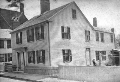
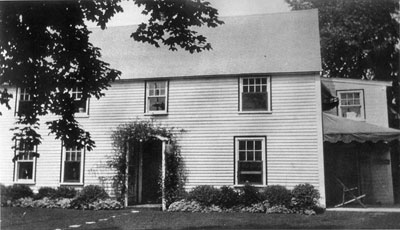
The Lane family was living at what is now 85 Middle Street, Gloucester, Massachusetts when Nathaniel Rogers Lane was born on December 19, 1804, and he continued to reside there until he moved to Boston, as Fitz Henry Lane, around 1832. This house is now gone, replaced by the brick building of the old Gloucester Cooperative Bank. Also in the house had been his father Jonathan Dennison Lane, a sail-maker, who died in 1816; his mother Sarah Haskell Lane and his older brother Edward who lived there until 1839; and his younger sister Sarah Ann Lane who lived there until she married Ignatius Winter in 1834 and moved to Boston.
Fitz Henry's residence in Boston lasted from the early 1830s until his return to Gloucester in 1849, but his home addresses are not established. He had studios at various locations—7 Summer Street, 17 School Street, 16 Tremont Temple, and 28 Joy's Building at 77–85 Washington Street. It is possible that he lived with his sister and her husband and their growing family near Haymarket Square, mostly on the now-lost Friend Street. Ron Polito has established his studio in room 16 of Tremont Temple for the years 1843 to 1850.
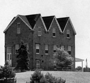
When Lane visited Gloucester while living in Boston, he stayed at his family's house on Middle Street until 1839, and then at his mother and brother's house at 179 Washington Street, near the entrance to the Oak Grove Cemetery. He also had a studio on Elm Street, where now a parking lot lies behind the Cape Ann Museum. This accommodation lasted until the stone house on Ivy Court, Duncan's Point, was completed in 1851 and he and the large Winter family moved into it. Fitz Henry lived in the Stone House for the rest of his life. His sister Sarah, her husband Ignatius Winter, and their seven surviving children, lived there also until they were evicted by a bit of legal and real-estate dealing by Lane's friend Joseph L. Stevens. After that, Lane lived in peace with a housekeeper, probably his cousin Mrs. Elizabeth Haskell Galacar and her daughter Allie, from 1862 until August 13, 1865, when he died.
– Sarah Dunlap (June, 2015)
1882
85 Middle Street is Lane's birthplace. In Lane's day the house wouldn't have had the extension in the back.
Also filed under: Chronology »
The house at 179 Washington Street, at one time the home of Fitz Henry Lane, was built c. 1700 of plank frame construction.
Also filed under: Chronology »
c.1979
Ivy Court was the name of the street where Lane built his stone house. "A path that became known as Ivy Court ran up the hill to the southeast from Locust Street. Lane built his stone house on top of the hill, along the southwest side of Ivy Court . . ."
From Buck and Dunlop, Fitz Henry Lane: Family and Friends, p. 152.
Also filed under: Chronology » // Lane's Stone House, Duncan's Point »
9.18.1830 Newspaper "Distressing Fire" col. 1 Gloucester Telegraph American Antiquarian Society
A great fire swept through Main St. in Gloucester:
“We have been called to witness the most distressing calamity which has ever visited our citizens. A considerable part of our town is in ruins. On Thursday morning, about 4 o’clock fire was discovered in the house owned and occupied by Samuel Gilbert, in Front Street, and is supposed to have commenced in a building in rear of said house, though the exact spot in which it originated is not accurately known, The flames spread with such rapidity, notwithstanding the calmness of the atmosphere, that no effectual check could be given, until they had destroyed upwards of 20 dwelling houses, together with about 40 stores, mechanic’s shops and other smaller buildings. These were mostly on the south side of the street, and between it and the water. Crossing the street, however, it destroyed several buildings, but was fortunately arrested at the store of Kimball & Hough, by demolishing two small buildings adjoining. It was finally checked by the arrival of assistance from Sandy Bay, Essex, Manchester and Ipswich, the engines from those places rendering the most important services, as without them the greater part of the village must have been consumed. We feel very grateful to the citizens of the above named places as well as to those of Salem, Beverly, Danvers & Marblehead. They set out very promptly at the first information of our distress, but in consequence of the general confusion & anxiety that prevailed, suitable measures were not taken to obtain seasonable aid from the most distant of these towns.
The disaster has fallen upon that part of our town in which the most business was transacted, and the sufferers are among our most active and enterprising citizens. No correct estimate of the losses sustained can, at present be made. – Great praise is due to the citizens generally for their intrepidity and vigorous exertions on this occasion . . . “
Lane was not mentioned by name, but he would have removed his furniture along with others.
Also filed under: Biographical information » // Chronology » // Newspaper / Journal Articles »

1834–35 Lithograph 24 x 38 in. Gloucester City Archives
"Drawn on a scale of one hundred feet to an inch. By John Mason 1834–45 from Actual Survey showing every Lott and building then standing on them giving the actual size of the buildings and width of the streets from the Canal to the head of the Harbour & part of Eastern point as farr as Smith's Cove and the Shore of the same with all the wharfs then in use. Gloucester Harbor 1834–35."
This map shows the location of F. E. Low's wharf and the ropewalk. Duncan's Point, the site where Lane would eventually build his studio, is also marked.
The later notes on the map are believed to be by Mason.
Also filed under: Duncan's Point » // Gloucester Harbor, Inner / Harbor Cove » // Low (Frederick G.) wharves » // Low, Capt. Frederick Gilman » // Maps » // Mason, John » // Ropewalk » // Somes, Capt. John »
1837 9 x 14 in. Cape Ann Museum Library & Archive
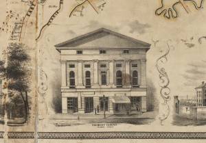
Showing Lane's neighborhood while working in Boston. Lane had studios at the intersection of Washington and State Streets, Summer, Tremont and School Streets.
Also filed under: Boston City Views » // Lane & Scott's, Lith. – Boston » // Maps » // Professional » // Tremont Temple »
1847 Map insert to Boston Almanac and Directory Cape Ann Museum Library & Archive
Also filed under: Boston City Views » // Maps » // Tremont Temple »
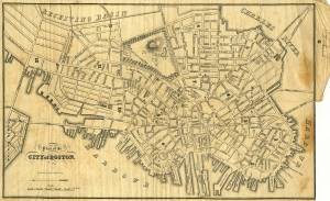
1852 Boston Boston Public Library: Norman B. Leventhal Map Center Call Number: G3764.B6 1852.M35
Also filed under: Boston City Views » // Maps »
1852 Boston Norman B. Leventhal Map Center at Boston Public Library Call Number: G3764.B6 1852.M35
Lane's studio was in the vicinity of the Tremont Temple
Also filed under: Tremont Temple »
1854 Newspaper "Letters on Art. - No. IV"
"In that space [four years] the town has grown greatly . . . a great ugly, yellow "Pavilion" suns itself on the rocks . . . I said there are only two stone buildings in this town of Gloucester: one is "the Bank," the other belongs to Mr. F. H. Lane, whose name ought to be known from Maine to Georgia as the best marine painter in the country.
If Mr. Lane is not as well known as he ought to be, he has at least no reason to complain of neglect or want of appreciation. He has been painting only fifteen years, and his pictures are in great demand; hitherto chiefly among sea-faring men, but now winning way in other circles. In former times I used to be often in Mr. Lane's painting-room, and it was with real pleasure that I found my way to his new house, built from his own design, of native granite, as I mentioned, handsome, peculiar, stable, and commanding a wide sweep of land and ocean from its ample windows. The house is the best that has been built in Gloucester for fifty years. . .
Mr. Lane has put few pictures in his studio at present; for he is very industrious, and sends his canvases off as fast as they are filled. If you were to meet him in the street, you would hardly take him for an artist. A man apparently of forty years, walking with difficulty, supported by crutches, hard-handed, browned by the sun and exposure, with a nose indicating less the artist sensibility than the artist resolution . . .
His early pictures had something in them too hard and practical to permit enthusiastic admiration; the water was salt, the ships sailed, the waves moved, but it was the sea before the Spirit of God moved upon the face of the deep.
His pictures early delighted sailors by their perfect truth. Lane knows the name and place of every rope on a vessel; he knows the construction, the anatomy, the expression – and to a seaman every thing that sails has expression and individuality . . . [Lane] has earned his money thus far mostly by painting "portraits" of vessels for sailors and ship-owners. It is owing to this necessity, perhaps, that he has fallen into the fault of too great literalness of treatment, which I have mentioned as characterizing some of his earlier works; but with the rapid advance he has made in the past four years, there is no longer any fear that he is incapable of treating a subject with genuine imagination . . .
He has indulged in no tricks and no vagaries; he has slighted nothing, despised nothing. If I appear to think less of his early pictures than they deserve, it is not because they are carefully even painfully studied, and because no detail has escaped his eye or brush; it is not that he has too much conscience; but simply because I missed in them the creative imagination of the artist. But it may well be a question whether at this day, when slight and untruthful work prevails, when artists will not paint with conscience, and the public does not strenuously demand it, conscience and love are not higher needs than imagination, and whether Mr. Lane's early pictures, the landmarks on his toilsome, earnest journey to his present place, have not a great value of their own. There is not one of them that I have seen, without some valuable passage, showing acute observation and careful, studious execution.
A sea-piece, "Off the coast of Maine, with Desert-Island in the distance," is the finest picture that Mr. Lane has yet painted. The time is sunset after a storm. The dun and purple clouds roll away to the south-west, the sun sinks in a glory of yellow light, flooding the sea with transparent splendor. Far away in the offing, hiding the sun, sails a brig fully rigged . . . I urged Mr. Lane to send this picture to New-York for exhibition . . ."
Also filed under: Newspaper / Journal Articles » // Pavilion Hotel »
9.1855 Newspaper
"Business Directory Listings"
Artists – Fitz H. Lane, residence on Duncan Street
Addison Center, residence on Washington St.
Also filed under: Center, Addison » // Newspaper / Journal Articles »
"Mr. Fitz H. Lane informs us that he counted on one strawberry plant in his garden, 205 berries. He had several plants which bore 150. We have not heard of any one's going ahead of this – If it has been eclipsed we would like to publish it."
Also filed under: Chronology » // Newspaper / Journal Articles »
1857 Newsprint Courtesy of the American Antiquarian Society, Worcester, Mass.
See p. 1, columns 1 and 2.
"Artists. / Fitz H. Lane, residence on Duncan street. / Addison Center, residence on Washington street. / Alfred J. Wiggin, Annisquam."
Also filed under: Newspaper / Journal Articles » // Procter Brothers » // Professional » // Winter, Ignatius »
Newsprint, various dates, from bound volume owned by publisher Francis Procter. Collection of Fred and Stephanie Buck.
"We saw on Thursday afternoon some full-blown 'ladies' delights,' picked in the open garden of Mr. Fitz H. Lane. they were as bright and beautiful as in their own proper season."
Also filed under: Chronology » // Newspaper / Journal Articles »
6.28.1861 Newsprint Cape Ann Advertiser Collection of Fred and Stephanie Buck
About the two magnolia trees in his garden:
"THE MAGNOLIA SEASON has arrived, and we have been favored with a fine bunch the present week from a friend, who will please accept our hearty thanks. It has been supposed that this fragrant flower could not be transplanted into our gardens and live, but must be confined to the swamps where they originally grow, but this is a mistaken idea, for there are several magnolia trees in town which have been transplanted, and are dowing well. Mr. Fitz H. Lane has two trees in a very flourishing condition in his garden, and the flowers are much larger than those in the wild state; all that is necessary is to keep them well watered, and protect them in winter by covering them with straw. We wonder that there are not more of them cultivated, for certainly they are the most fragrant of all flowers."
Also filed under: Chronology » // Newspaper / Journal Articles »
6.11.1879 Newspaper Cape Ann Bulletin Advertisement for the late Fitz H. Lane's house Cape Ann Museum Library & Archives
Desirable Residence For Sale.
The stone cottage house, on Ivy Hill, Gloucester, built by the late Fitz H. Lane, marine artist, and lately occupied by Capt. F.G. Low, deceased, is to be sold. It commands a fine view of the harbor and city, has a large lot of land well stocked with fruit and ornamental trees and shrubs, and is very near Post Office and Railroad Station, making it a desirable summer or permanent residence. For particulars apply to David W. Low, Gloucester, Mass.
1903 Four-page letter Collection of the Cape Ann Museum Library & Archive, Gloucester, Mass.
"[The painting] is offered you for $150 on as long time and in as many notes at 3% interest as you choose. . . I believe this to be the only important painting of Gloucester Harbor that Lane never duplicated. . . .Returning from a Gloucester visit while I was still under the roof there, father brought a print of Lane's first Gloucester view, bought of the artist at his Tremont Temple studio in Boston. An extra dollar had been paid for coloring it. For a few years it was a home delight.. . .I had been a few years in Gloucester when Lane began to come, for part of the time a while, if I remember rightly. He painted in his brother's house, "up in town" it then was. I recall visits there to see his pictures. But it was long after, that I could claim more than a simple speaking acquaintance. The Stacys were very kind, aiding him as time went on in selling paintings by lot. I invested in a view of Gloucester from Rocky Neck, thus put on sale at the old reading room, irreverently called "Wisdom Hall." And they bought direct of him to some extent, before other residents. Lane was much my senior and yet we gradually drifted together. Our earliest approach to friendship was after his abode began in Elm Street as an occupant of the old Prentiss [sic-corrected Stacy] house, moved there from Pleasant. I was a frequenter of this studio to a considerable extent, yet little compared with my intimacy at the next and last in the new stone house on the hill. Lane's art books and magazines were always at my service and a great inspiration and delight—notably the London Art Journal to which he long subscribed. I have here a little story to tell you. A Castine man came to Gloucester on business that brought the passing of $60 through my hands at 2 1/2 % commission. I bought with the $1.50 thus earned Ruskin's Modern Painters, my first purchase of an artbook. I dare say no other copy was then owned in town. . . .Lane was frequently in Boston, his sales agent being Balch who was at the head of his guild in those days. So in my Boston visits – I was led to Balch's fairly often – the resort of many artists and the depot of their works. Thus through, Lane in various ways I was long in touch with the art world, not only of New England but of New York and Philadelphia. I knew of most picture exhibits and saw many. The coming of the Dusseldorf Gallery to Boston was an event to fix itself in one's memory for all time. What talks of all these things Lane and I had in his studio and by my fireside!
For a long series of years I knew nearly every painting he made. I was with him on several trips to the Maine coast where he did much sketching, and sometimes was was [sic] his chooser of spots and bearer of materials when he sketched in the home neighborhood. Thus there are many paintings whose growth I saw both from brush and pencil. For his physical infirmity prevented his becoming an out-door colorist."
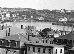
c.1869 Glass plate negative Cape Ann Museum Library & Archive Detail from CAHA#00279
The magnificent views of Gloucester Harbor and the islands from the top floor of the stone house at Duncan's Point where Lane had his studio were the inspiration for many of his paintings.
From Buck and Dunlop, Fitz Henry Lane: Family, and Friends, pp. 59–74.
Also filed under: Duncan's Point » // Gloucester Harbor, Inner / Harbor Cove » // Lane's Stone House, Duncan's Point »
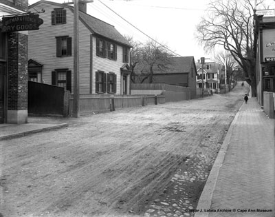
1897
Elm Street looking toward Prospect Street 1897. Gambrel moved from 17 Pleasant Street in 1842 by Harvey Coffin McKay to build his new house. F. H. Lane lived and worked in this Gambrel at 8 Elm Street with his sister and brother-in-law for several years until the stone house on Duncan Street was built in 1850. See Stephanie Buck,Fitz Henry Lane, Family and Friends, p. 51.
2020, Urban Renewal and the Fitz Henry Lane House Online Exhibition, Cape Ann Museum
This online archival exhibition details the survival of Lane's house on Duncan's Point through the efforts of civic leaders during Urban Renewal in Gloucester in the 1950s.
Also filed under: Lane's Stone House, Duncan's Point »
Marks: Inscribed upper left (in red ink): 71 [numbering system used by curator A. M. Brooks upon Samuel H. Mansfield's donation of the drawings to the Cape Ann Museum]