An online project under the direction of the CAPE ANN MUSEUM
Catalogue Entry
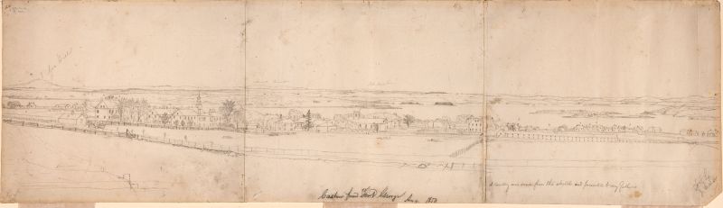
Most of the inscriptions on Lane's drawings are believed to be by his friend and the executor of his estate, Joseph Stevens, Jr. This has led to some confusion about the original owner of the painting made after this drawing, now thought to be Joseph Stevens, Sr.
- Subject Types
: - Landscape Types
: - Maine Buildings & Locales
: - New England Locales
: - Maine »
- Building Types
:
Historical Materials
Newsprint
Gloucester Daily Telegraph
Article by Joseph L. Stevens
"The beauties of this place [Maine] are well known and appreciated among artists. We heard of Bonfield and Williams who had reluctantly left but a short time before. Fishe had spent several weeks there. Champney and Kensett were then in another part of the island, and we have reason to believe that Church and some others were in the immediate vicinity–Lane who was with us, made good additions to his portfolio."
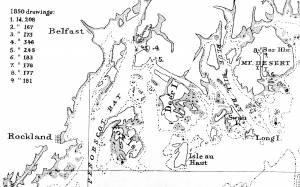
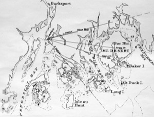
Chart
U.S. Coast Survey
View related catalogue entries (9) »
Filed under: Penobscot Bay »
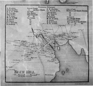
Blue Hill is a community east of Castine, across the water from Mount Desert, with a protected harbor. The hill which gives the town its name can also be seen from Castine. In 1850 the population was 1939 (Maine Register). Blue Hill had a fair amount of ship-building, but also quarrying and shipping of granite. According to the 1855 Maine Register, "There is shipped from Bluehill from twenty to fifty thousand dollars worth of rough and hewed granite, per annum." (1)
Awan-adjo, from "Awan," "fog and mist," and "-adjo, "lone hill of the sugar loaf type," perhaps of recent origin, or "K'chi-awan-adn-ock," "the big hazy mountain," was a landmark for the Wabenaki traveling to and fro along the "Minnewo'kun." Parson Jonathan Fisher called it Bluehill in his journal of April 1, 1809. The 934 foot "mountain" appears to be hazy or blue, depending upon your fancy, as you gaze upon its heights from the sea. Township 5, as it was designated in the survey of 1762, sits on Bluehill Bay, but it was not until 1788 that the citizens decided to rename the town Bluehill. The Act of Incorporation spelled the name Blue Hill, and this has led to a continual controversy over the name, as some still prefer Bluehill over Blue Hill.
"There is here a remarkable neat little village chiefly of farmers and the lands are good," so wrote Alexander Baring of London of his grand tour of North America, from the Hudson River to the St. Lawrence, and from the St. Lawrence and the St. John River to the Downeast Coast in 1797. This neat little village opened its own Bluehill Academy in 1803, providing an excellent education in science, mathematics, language, history, and literature for both young men and women, and published its own newspaper 1830-32. Joseph Wood and John Roundy arrived at Bluehill Bay on April 7, 1762, from Beverly, MA, and commenced getting out staves near Fore Falls. By 1768 lumber was being shipped to the West Indies. The Carleton brothers built a tide sawmill near the Salt Pond in 1770. As with every community Downeast, sawmills, fish houses, shipyards, and small, tidy farms were quickly established, and by the 1850s, Bluehill had blossomed into a neat, prosperous village of mariners, farmers, merchants, shipwrights, and millmen.
– Mark Honey
Reference:
1. George Adams. The Maine Register for the Year 1855, p.258
Also see:
Fannie Hardy Eckstrom, Indian Place-Names of the Penobscot Valley and the Maine Coast, University of Maine Studies, 2nd Series, #55, November 1941, reprinted 1960 by the University of Maine Press. DeLorme's Atlas, Frank G Speck's Penobscot Man, University Of Pennsylvania Press, 1940, and Eckstorm, among others, provide useful information on Minnewo'kun.
William Hinckley (1913–83), Bits of Local History, a compendium of re-published articles originally written for "The Weekly Packet" of Bluehill. As printed April 17, 1975 and August 11, 1977
Mark E. Honey, "Abigail & Sarah Hawes of Castine," in Navigators & Educators, with Lois Moore Cyr, 1996.
Mark E. Honey, "King Pine, Queen Spruce, Jack Tar," in An Intimate History of Lumbering on the Union River, vols. 1–5. This source, in its entirety, lays down the foundation of Downeast Maine's unique culture which was built upon pine lumber and timber, the cod fisheries, coasting, shipbuilding, and the interrelationships of family and community.
Personal diary
Wilson Museum, Castine, Maine (A00060-1a-1h)
Description of an excursion taken by Joseph Stevens, Jr., Lane, Witherle, Samuel Adams, Jr., and George Tilden around the islands of Maine near Mt. Desert. The group hired the Sloop "Superior" which was owned by Pilot Getchell. In his diary, Witherle mentions multiple times that "Lane took a sketch" especially when the water was calm. Lane often stayed on board the boat, while the others went ashore.
Excerpts of the diary include:
August 16: "Lane has a knack for frying fish."
August 17: "leaving Lane to take a sketch, we took a climb."
August 19: "went to ascend one of the highest mountains. 3/4 the way up we had to wait – once in a while for Lane who with his crutches could not keep up with us – but got along faster than we thought possible . . .Lane got up about an hour after the rest of us."
The entire text is transcribed in an account published by the Wilson Museum.
View related catalogue entries (6) »
Also filed under: "Superior" (Sloop) » // Adams, Samuel, Jr. » // Biographical information » // Castine » // Chronology » // Diaries / Ledgers / Etc. » // Mount Desert Island & Rock » // Somes Sound » // Stevens, Joseph, Jr. » // Tilden, George » // Witherle, William Howe »
Brooksville is on the point of land located just across the harbor from Castine, and islands, such as Ram Island (located between Castine and Cape Rosier) would have been easily accessible by boat from Castine.
Indian Bar, on Cape Rosier, was one the routes of the Wabenaki Indians from the Penobscot River to Mount Desert, Deer Isle, or the islands of Penobscot Bay. The Indian Bar provided a short portage into Smith Cove, crossing Cape Rosier to Horseshoe Cove, and from thence to Eggemoggin Reach, from whence one could follow one route to Benjamin River and Salt Pond to Bluehill Harbor, another to Naskeag and Mount Desert, a third to Deer Isle and the outer islands of Penobscot Bay, and a fourth from Billings Cove and Walkers Pond to the Bagaduce River. Coming full circle, one crossed from the Bagaduce to Hatch's or Poverty Cove, above Castine village, to Wadsworth's Cove, and from thence north along the Penobscot. Wadsworth's Cove was the beginning or ending of the Minnewo'kun, "the many directions route."
There isn't much history to relate about Ram Island, other than, as its name suggests, it was used as a sheep pasture, perhaps in connection with the farm at Holbrook Island. Holbrook, or Smart's Island, was occupied prior to the Revolution, and was purchased by Smart's brother-in-law, John Bakeman, and was thus known as Bakeman's Island in 1779. John Bakeman, a shipbuilder and sawmill owner at Goose Falls, Cape Rosier, sold the island to Capt. Jesse Holbrook for £150 in 1783. Capt. Jesse Holbrook died on the island on September 20, 1791 and is buried there with some of his children.
Capt. Jonathan Holbrook, Capt. Jesse's son, sold the island to Capt. Elisha Dyer of Castine in 1801 and removed his family to Northport. The extended Holbrook family would include shipbuilders at Penobscot, Castine, and Islesboro, a fraternity of shipwrights and a pattern of craftsmanship that would define shipbuilding in Hancock County in the nineteenth century. Capt. Holbrook lost his schooner "President," built at Islesboro by his brother-in-law Mighill Parker 1796, to French privateers in the West Indies in 1797, and the schooner "Active" to French privateers, who were interned captured by English privateers in 1800. Benjamin Hook Senior and Abraham Moor, farmers, were living together in an extended household, in 1850, on Holbrook Island, which included Robert Bowden, a mariner. Moor, according to oral history, was expelled from Yale, and spent the remainder of his life as a local eccentric. The Neymans, who also lived on the island, are alleged to be the children of Hook's inamorata Mrs. Ryder.
– Mark Honey
References:
Fannie Hardy Eckstorm, "Indian Place-Names of the Penobscot Valley and the Maine Coast," University of Maine Studies, 2nd Series, #55, November 1941, reprinted 1960 by the University of Maine Press. DeLorme's Atlas, Frank G Speck's "Penobscot Man," University Of Pennsylvania Press, 1940, and Eckstorm, among others, provide useful information on Minnewo'kun.
Mark E. Honey, "Before the Mast," vol. IV, articles 7–9, Holbrook Island and the Holbrook family, and in particular, Robert Applebee, "Vessels of the Penobscot Customs District," Stephan Phillips Memorial Library, Penobscot Marine Museum, Searsport, which source also has the diaries of Capt. Jonathan Holbrook and the genealogy of the Holbrook family in the Priscilla Jones collection. The "Before the Mass" series can be found in the collections of the Castine Historical Society and the Wilson Museum, both in Castine.
Charles B. McLane, and Carol Evarts McLane, "Islands of the Mid-Maine Coast," Penobscot Bay, vol. 1, rev. ed., (Gardiner, ME: Tilbury House; in association with the Island Institute, Rockland, ME, 1982).
Harald E. L. Prins, and Bunny McBride, "Asticou's Island Domain: Wabenaki Peoples at Mount Desert Island," 1500–2000, Acadia National Park, Ethnographic Overview and Assessment, vol. 1, repaired under cooperative agreement with The Abbe Museum, Bar Harbor, Maine, Northeast Regional Ethnography Program, National Park Service, Boston, Massachusetts, September, 2007.
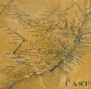
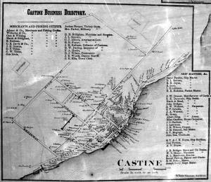
Castine is a town located on a sheltered harbor in Maine's Penobscot Bay. According to the Maine Register of 1850 it had a population of 1260.
Castine, as the seat of customs, registered 31.4% of Maine's sea fisheries tonnage in 1850. Castine's merchants serviced the needs of Penobscot Bay's fishermen, fitting up supplies and salt, and offering both employment and opportunities for investment in the cod fisheries. Beginning about 1824 Castine fitted out at least 300 vessels with more than two thousand men in a year. (1) Castine's shipyards built both fishing schooners and large ships, ships which carried cotton from New Orleans to the cotton mills of Great Britain, and returned with salt from Liverpool and Cadiz. Castine was at the height of its economic power in the 1850s, the commercial hub for the broader community of Penobscot Bay. (2)
In Gloucester, some aspects of the fishing industry were changing. The fishing vessels of Penobscot Bay tended to be smaller in size, more democratic in ownership, and more intimate with regard to crew, who were more often than not members of an extended family or from the same communities.
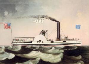
The steamboat lines began connecting Maine to Boston in 1824. In 1845 Captain Sanford's Independent Line tried his "Penobscot I" on the route that would become standard, an overnight route to Boston. He also initiated in 1846 "the Blue Hill line" which used the 130-foot "T. F.Secor" to connect with the Boston boat at Belfast and run up to Bangor and as far east as Blue Hill with landings both ways. During the 1850s steamers became larger and more luxurious, with competing steamer lines, and steamships also used in the lumber trade. (3)
References:
1.W.H. Bunting, A Day's Work: A Sampler of Historic Maine Photographs (Portland, ME: Maine Preservation), p.56.
2. Roger F. Duncan, "Coastal Maine, A Maritime History," WW Norton & Company, New York, 1992. Mark Honey, "King Pine, Queen Spruce, Jack Tar," An Intimate History of Lumbering on the Union River, Volumes 1-5. This source, in its entirety, lays down the foundation of Downeast Maine's unique culture which was built upon pine lumber and timber, the cod fisheries, coasting, shipbuilding, and the interrelationships of family and community.
3. Allie Ryan, Penobscot Bay Mount Desert, and Eastport Steamboat Album (Camden, ME: Downeast Magazine, 1972).
Honey, Mark E, "Abigail & Sarah Hawes of Castine," Navigators & Educators, with Lois Moore Cyr, 1996.
Honey, Mark E, "Before the Mast," Volume IV, articles 7-9, Holbrook Island and the Holbrook family, and in particular, Robert Applebee, "Vessels of the Penobscot Customs District," Stephan Phillips Memorial Library, Penobscot Marine Museum, Searsport, which source also has the diaries of Capt. Jonathan Holbrook and the genealogy of the Holbrook family in the Priscilla Jones collection. The "Before the Mass" series can be found in the collections of the Castine Historical Society and the Wilson Museum, both in Castine.
McLane, Charles B, and McLane, Carol Evarts, "Islands of the Mid-Maine Coast," Penobscot Bay, Volume 1, Revised Edition, Tilbury House, Publishers, Gardiner, Maine, and the Island Institute, Rockland, Maine.
McLane, Charles B, and McLane, Carol Evarts, "Islands of the Mid-Maine Coast," Mount Desert to Machias Bay, Volume 2, The Kennebec River club Press, Incorporated, Falmouth, 1989.
O'Leary, Wayne M, "Maine Sea Fisheries," The Rise and Fall of a Native Industry, 1830-1890, Northeastern University Press, Boston, 1996, pages 350-351, for the percentage of sea fisheries in 1850.
Personal journal
Wilson Museum, Castine, Maine
Box 2, F1 (A00772)
John Stevens was the younger brother of Joseph Stevens, and acquainted with Lane, spending time with him in Gloucester and at the family home in Castine. His journal, quoted below, includes reference to hunting plover and teal, school, sailing, local events. Mentions Castine mill, lighthouse, and block house.
"Friday [September] 17th: Cloudy all day. Wind N. blowing quite hard. A British Rig loaded with salt from Liverpool came into port last night. She run way up by the Monument and got aground. They kedged her off this P.M. and came down. She came in with one of these old English charts as her guide. They have the town set down on the Brooksville side, two miles + three quarters from the lighthouse."
"Wednesday [September] 22. . .Went down to the Indians Camp on the Back Cove. There were five camps of them."
Visits Gloucester from Castine:
"Wednesday [October] 27th. . .Left for Gloucester [from Boston] at 5 o'clock this P.M. arrived there safe + sound at 6 1/2 o'clock; went right down to the store and saw Joe. We then went up to his house and got supper.
"Thursday [October] 28th. At. Gloucester. Pleasant day. Went down to the "Cut" a gunning this morning before breakfast but saw no birds. Went out in the harbor this forenoon alone, had a fine sail but couldn't get a chance at any birds. Went out again this P.M. got down to East Point Light and the wind died all away, so I had to scull home."
"Friday 29th. Very pleasant day, went out in the harbor this morning with Joe. Took a walk this A.M. with "Lina", called on Mr. Lane + Doct. Hildreth. Joe + I went out in the harbor this P.M. I fired at some birds several times, but didn't get any. . . ."
Also filed under: Biographical information » // Bird Hunting » // Castine – School » // Chronology » // Cut, The (Stacy Blvd.) » // Diaries / Ledgers / Etc. » // Stevens, Joseph, Jr. »
Newspaper
"Mr. F. H. Lane of Gloucester . . .visits here nearly every summer"
Also filed under: Chronology » // Newspaper / Journal Articles »
Personal diary
Castine Historical Society
From July 25-August 16,1848, Castine native Noah Brooks made a return visit to his hometown. He was eighteen at the time, and had been living in Boston. In his diary, there is no mention of Lane, but he recounts Castine gossip, and writes about visits with the Stevens and Witherle familes, accounts of swimming in Back Cove, and reading Wuthering Heights. The daily arrival of "the boat" (the "T.F.S." or the "Secor")—the way it was anticipated and observed by Castine residents—is notable.
Also filed under: "T. F. Secor" (Steamboat) » // Brooks, Noah » // Diaries / Ledgers / Etc. » // Steamers » // Stevens, Joseph, Sr. and Dorothy Little » // Witherle, William Howe »
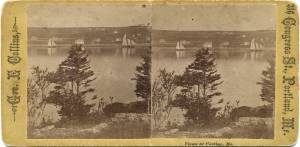
Stereograph card Castine Historical Society Collections (1996.1)
Also filed under: Historic Photographs »
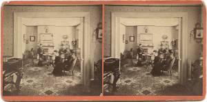
Stereograph card Castine Historical Society Collections (1998.34)
Also filed under: Historic Photographs »
Chart
U.S. Coast Survey
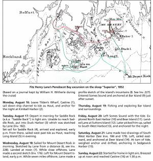
Chart with key showing the route of an excursion on the sloop "Superior" out of Castine made by William H. Witherle, Lane, Stevens and friends during which Lane made several sketches of Mt. Desert scenery. The trip was chronicled by Witherle in his diary of 1852.
Handwritten list
Wilson Museum, Castine, Maine (A00787-1a-1d)
Also filed under: Castine – Witherle & Co.'s Store » // Lithography (Sales & Exhibitions) » // Noyes, Samuel » // Publications » // Stevens, Joseph, Jr. » // Witherle, William Howe »
Stereograph card Castine Historical Society Collections (1996.1)
Also filed under: Castine, Maine – Dice (Dyce) Head Lighthouse » // Historic Photographs »
Photograph
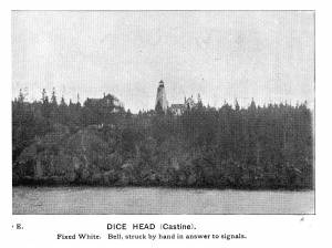
In The Illustrated Coast Pilot with sailing directions. The Coast of New England from New York to Eastport, Maine including Bays and Harbors, published by N. L. Stebbins, Boston, Mass.
Also filed under: Castine, Maine – Dice (Dyce) Head Lighthouse »
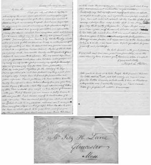
Letter
Cape Ann Museum, Gloucester, Mass.
Also filed under: "General Gates" (New England Boat; Casco Bay Boat) » // Chronology » // Letters » // Stevens, Joseph, Sr. and Dorothy Little »
1903 Four-page letter Collection of the Cape Ann Museum Library & Archive, Gloucester, Mass.
"[The painting] is offered you for $150 on as long time and in as many notes at 3% interest as you choose. . . I believe this to be the only important painting of Gloucester Harbor that Lane never duplicated. . . .Returning from a Gloucester visit while I was still under the roof there, father brought a print of Lane's first Gloucester view, bought of the artist at his Tremont Temple studio in Boston. An extra dollar had been paid for coloring it. For a few years it was a home delight.. . .I had been a few years in Gloucester when Lane began to come, for part of the time a while, if I remember rightly. He painted in his brother's house, "up in town" it then was. I recall visits there to see his pictures. But it was long after, that I could claim more than a simple speaking acquaintance. The Stacys were very kind, aiding him as time went on in selling paintings by lot. I invested in a view of Gloucester from Rocky Neck, thus put on sale at the old reading room, irreverently called "Wisdom Hall." And they bought direct of him to some extent, before other residents. Lane was much my senior and yet we gradually drifted together. Our earliest approach to friendship was after his abode began in Elm Street as an occupant of the old Prentiss [sic-corrected Stacy] house, moved there from Pleasant. I was a frequenter of this studio to a considerable extent, yet little compared with my intimacy at the next and last in the new stone house on the hill. Lane's art books and magazines were always at my service and a great inspiration and delight—notably the London Art Journal to which he long subscribed. I have here a little story to tell you. A Castine man came to Gloucester on business that brought the passing of $60 through my hands at 2 1/2 % commission. I bought with the $1.50 thus earned Ruskin's Modern Painters, my first purchase of an artbook. I dare say no other copy was then owned in town. . . .Lane was frequently in Boston, his sales agent being Balch who was at the head of his guild in those days. So in my Boston visits – I was led to Balch's fairly often – the resort of many artists and the depot of their works. Thus through, Lane in various ways I was long in touch with the art world, not only of New England but of New York and Philadelphia. I knew of most picture exhibits and saw many. The coming of the Dusseldorf Gallery to Boston was an event to fix itself in one's memory for all time. What talks of all these things Lane and I had in his studio and by my fireside!
For a long series of years I knew nearly every painting he made. I was with him on several trips to the Maine coast where he did much sketching, and sometimes was was [sic] his chooser of spots and bearer of materials when he sketched in the home neighborhood. Thus there are many paintings whose growth I saw both from brush and pencil. For his physical infirmity prevented his becoming an out-door colorist."
Single sheet, writing both sides
Cape Ann Museum Library & Archives, Gloucester, Mass.
"My dear Sir,
I hope you will not attribute the delay in acknowledging the receipt of your splendid, and most unexpected Gift to a want of a due appreciation of it. Many reasons have consipired to prevent my doing it – unnecessary to repeat. But I can no longer defer the expressions of our warmest acknowledgements for a present in itself so valuable, and endeared to us by many associations, as a representation of scenery often admired, and which I have many times wished could be transferred to canvas, although vary far from thinking that wish would ever be gratified. You must premit me, however, to say that the Painting, valuable as it is as a work of Art, and pleased as I may be as the possessor of it, is less appreciated by us than the delicate and very generous manner in which its acceptance has been tendered. My love of Art, to which you do politely allude, I am sensible has only wanted opportunity of indulgence to have amounted to a passion. From my earliest days I have wished for opportunities to visit places, where that desire could be gratified, and my reading has only had the effect of increasing my regrets for the want of them, and of encouraging envy for those more fortunate - I feel, too, under great obligations for the Drawing of the "Siege"(1) – I had no expectations you could have produced anything so good from so rough a copy. I shall have it framed for presentation and future reference. Several gentlemen who have called in to see the painting have expressed a desire to have a drawing from you of our town, similar to yours of Gloucester, which they much admire, and of lithographs, I have no doubts copies enough could be disposed of to remunerate you. That of Homans you are aware is feebly drawn, & still worse printed. I feel desirous myself it should be done, if it suits your wishes. There are several points of view, which you did not see, & to which it will be my pleasure, next summer, to carry you. I know many of our citizens would be gratified to have this done by you. Our house we shall expect to be your home, and if, as you suggested in Gloucester, you should come in your Boat, this place could be made the rendezvous, from whence you could start to any place that convenience & inclination might dictate – . . . Permit me again to tender acknowledgements for the picture. It hangs in our parlor, & I never come in to the house, without looking in to see it, & can never cease to feel grateful for your generosity and politeness. "
(1) Joseph Stevens was very interested the Revolutionary war event known as the "Penobscot Expedition" or the "Siege of Castine" by the British on July 25, 1779. In 1852 he handwrote an account of it and many articles are in the family's scrapbook at the Wilson Museum in Castine.
Details about Maine's fishing industry, see pp. 256–57.
Also filed under: Grand Bank, Newfoundland, Canada » // Statistics »
"The Maine Register for the Year 1855, embracing State and County Officers, and an abstract of the law and resolves; together with a complete business directory of the state, and a variety of useful information."
Details about Maine's lumber trade in 1855, see pp. 250–52
Also filed under: Lumber Industry » // Schooner (Coasting / Lumber / Topsail / Packet / Marsh Hay) »
Details about Maine's shipbuilding industry, see pp. 252–57.
Also filed under: Shipbuilding / Repair »
Oil on canvas
Maine Maritime Museum
Also filed under: Steamship / Engine-Powered Vessel / Coastal Steamer »
Steamer schedules for 1855, including the schedule for the steamer, "T. F. Secor" which served Castine, see pp. 234–35.
Also filed under: "T. F. Secor" (Steamboat) » // Publications » // Steamers » // Steamship / Engine-Powered Vessel / Coastal Steamer »
Wilson Museum, Castine, Maine.
Library of Congress Catalog Number 2011588006
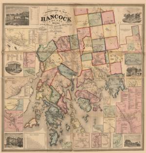
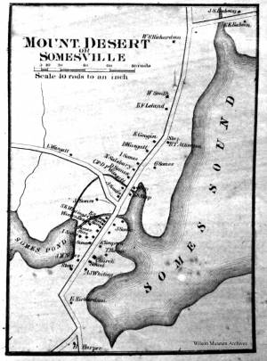
1860 map, including census of towns.
Also filed under: Maps » // Mount Desert Island & Rock » // Penobscot Bay »
1860
Also filed under: Maps »
Library of Congress catalog number 2011588006
Wilson Museum, Castine, Maine also has a copy of the map
Also filed under: Maps »
Wilson Museum, Castine, Maine also has a copy of the map
Library of Congress catalog number 2011588006
Also filed under: Maps »
Bouvé and Sharp, Lithographers, 221 Washington Street, Boston
Boston Athenaeum
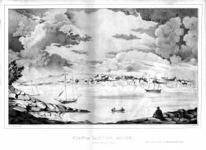
Looking at Castine from Hospital Island. Joseph Stevens, Sr. mentions this print in the letter he wrote to Lane encouraging Lane to make a lithograph of Castine.
Also filed under: Bouvé & Sharp, Lith. – Boston » // Homan, S.V. » // Stevens, Joseph, Sr. and Dorothy Little »
Personal diary
Wilson Museum, Castine, Maine (A00060-1a-1h)
Description of an excursion taken by Joseph Stevens, Jr., Lane, Witherle, Samuel Adams, Jr., and George Tilden around the islands of Maine near Mt. Desert. The group hired the Sloop "Superior" which was owned by Pilot Getchell. In his diary, Witherle mentions multiple times that "Lane took a sketch" especially when the water was calm. Lane often stayed on board the boat, while the others went ashore.
Excerpts of the diary include:
August 16: "Lane has a knack for frying fish."
August 17: "leaving Lane to take a sketch, we took a climb."
August 19: "went to ascend one of the highest mountains. 3/4 the way up we had to wait – once in a while for Lane who with his crutches could not keep up with us – but got along faster than we thought possible . . .Lane got up about an hour after the rest of us."
The entire text is transcribed in an account published by the Wilson Museum.
View related catalogue entries (6) »
Also filed under: "Superior" (Sloop) » // Adams, Samuel, Jr. » // Biographical information » // Blue Hill » // Chronology » // Diaries / Ledgers / Etc. » // Mount Desert Island & Rock » // Somes Sound » // Stevens, Joseph, Jr. » // Tilden, George » // Witherle, William Howe »
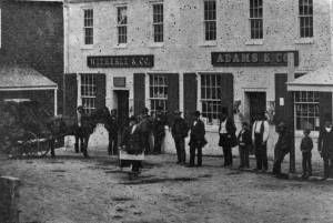
Photograph
Wilson Museum, Castine, Maine
Accession number a02600a
Also filed under: Castine – Witherle & Co.'s Store » // Witherle, William Howe »
John Dresser built a ropewalk in Castine; by 1826 the family had two ropewalks (one in Thomaston run by his brother Israel, and one in Castine run by John). Ropewalks were long wooden structures built so that men could walk the length and weave hemp into the line. They were apt to burn.
J. W. Dresser was John's son and born in 1826. He later operated the Castine rope walk, which remained in the family until 1900 despite having burned twice and having to be rebuilt. "The foreman was a pleasant and capable Italian who was called 'Mr.Surry' (which was not his name but easy to pronounce). He devised an improvement in the process which kept the line from kinking or snarling easily and the 'Castine line' was famous from the Maritime provinces to at least Boston" (Sargent MS letter at Wilson Museum as in Doudiet p. 65).
Among the collection of Stevens papers at the Wilson Museum is a receipt received by Joseph L. Stevens, Sr. from John Dresser in 1838 for rope purchased (A00778).
Wilson Museum, Castine (A02428)
On the back of the photo, written:"Business was run by John Dresser – but the sacred process of curing the lines was devised by an employee – and Italian– but called "Surry." "The Castine Lines" were well known in fishing interests from Boston to the Provinces.
After the long lease was out of this land, Mr. E. H. Carpenter built a new factory on rhe north end. The new factory was struck by big storm."
Also filed under: Historic Photographs »
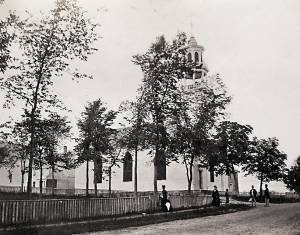
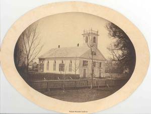
At 88 Court Street, Castine, was the church built between 1790–96 as First Parish Church and greatly remodeled in 1831. It served as the First Parish (Congregational) Church from 1796–1866, after which it became a Unitarian parish. It is noteworthy for its distinctive belfry and spire. Part of the 1831 reconstruction was this new tower, as well as the sending back of the original Revere bell to Boston in exchange for a larger one. Dr. Joseph Stevens was listed as a pew holder in this church in 1832. (2) During the 1840s the congregation at this church dwindled, but the church was still used for town events such as the 4th of July during the Civil War. (2)
References:
1. Lynn Hudson Parsons, Missions and Meeting Houses, Chapels and Churches: Fuor Centuries of Faith in Castine, Maine (Castine, ME: Historical Society, 2012), 60.
2. Ibid., 75.
Photograph Castine Historical Society Collections
Also filed under: Historic Photographs »
Fort George is located on the hill above the harbor town of Castine. By Lane's time, like many old forts, it was used for walking, visiting the historic sites, and sporting and celebratory (4th of July) events.
During Lane's time the school in town that was visible from the water was the one that served as the high school and was a two-story building on the town green. The building is still standing and is called the Adams school; it is now Castine's elementary school. In his diary of 1852 John Stevens (Joseph Stevens's younger brother) documents his days at this school during the autumn hours when he was not bird hunting.
Personal journal
Wilson Museum, Castine, Maine
Box 2, F1 (A00772)
John Stevens was the younger brother of Joseph Stevens, and acquainted with Lane, spending time with him in Gloucester and at the family home in Castine. His journal, quoted below, includes reference to hunting plover and teal, school, sailing, local events. Mentions Castine mill, lighthouse, and block house.
"Friday [September] 17th: Cloudy all day. Wind N. blowing quite hard. A British Rig loaded with salt from Liverpool came into port last night. She run way up by the Monument and got aground. They kedged her off this P.M. and came down. She came in with one of these old English charts as her guide. They have the town set down on the Brooksville side, two miles + three quarters from the lighthouse."
"Wednesday [September] 22. . .Went down to the Indians Camp on the Back Cove. There were five camps of them."
Visits Gloucester from Castine:
"Wednesday [October] 27th. . .Left for Gloucester [from Boston] at 5 o'clock this P.M. arrived there safe + sound at 6 1/2 o'clock; went right down to the store and saw Joe. We then went up to his house and got supper.
"Thursday [October] 28th. At. Gloucester. Pleasant day. Went down to the "Cut" a gunning this morning before breakfast but saw no birds. Went out in the harbor this forenoon alone, had a fine sail but couldn't get a chance at any birds. Went out again this P.M. got down to East Point Light and the wind died all away, so I had to scull home."
"Friday 29th. Very pleasant day, went out in the harbor this morning with Joe. Took a walk this A.M. with "Lina", called on Mr. Lane + Doct. Hildreth. Joe + I went out in the harbor this P.M. I fired at some birds several times, but didn't get any. . . ."
Also filed under: Biographical information » // Bird Hunting » // Castine » // Chronology » // Cut, The (Stacy Blvd.) » // Diaries / Ledgers / Etc. » // Stevens, Joseph, Jr. »
Stereograph card Castine Historical Society Collections (2007.09)
Also filed under: Historic Photographs »
In 1820 there was a split among the parishioners of Castine's Congregational Parish, some of whom split off to form the Trinitarian Society of Castine. They constructed a building in 1829 at 68 Main Street, which was, for many years referred to as Castine's Second Parish.
Reference:
Lynn Hudson Parsons, Missions and Meeting Houses, Chapels and Churches: Four Centuries of Faith in Castine, Maine (Castine, ME: Historical Society, 2012), for more information on the history of Castine's churches.
after 1850 Wilson Museum, Castine, Maine (a2045-1)
Also filed under: Historic Photographs »
Mount Desert was in the Frenchman's Bay Customs District, and in 1850 the district ranked 4th, at 11.2%, among Maine's 13 customs districts, for its investment in the cod fisheries. The thick, old-growth forest provided ample opportunity for sawmills and the export of pine lumber and timber, as well as shipbuilding, which went hand-in-hand with fishing vessels for the cod fisheries.The coasters of the island found ample freight in the shipment of lumber from the sawmills of the Union River at Ellsworth. The rugged interior of the island limited settlements to the coastal fringe, creating a number of independent, isolated communities. Mount Desert's small fishing and farming communities, in the early 1850s, were set like small diamonds in an incredible crown of natural beauty. These small, isolated villages, clinging to a jagged coastline which stood resolute against the breaking sea, would have reminded artists like Lane of an America untouched by the progress of time. This was New England as it had once been, and there were few places in coastal New England where this claim could still be made.
Mount Desert, as it is colloquially known, has been known by many names throughout its history. The Etchemin called it Pem-etn-ic, "a range of mountains," as seen from the sea, "where the hills rise in a long saw-toothed range," Champlain called the island, notable for its granite mountains, of which one rises 1530 feet , "Isle des Monts Deserts," "barren mountains Island," and Sieur de la Mothe de Cadillac, who was granted a large tract at the head of Frenchman Bay in 1687, called Douaquet. Cadillac is one of a number of Frenchman whose presence in history is denoted by Frenchman's Bay.
At the beginning of recorded history Asticou was an Etchemin Sakom who lived seasonally on Mount Desert with his band. His larger homeland, Ketakamigwa, "the big land on the seacoast," was "an ecologically diverse coastal woodland environment, combining a saltwater archipelago with a 1000 mi.² freshwater hinterland broken by hills, swamps, lakes and ponds, and drained by a few major rivers in numerous smaller streams." The highly mobile Wabenaki families, ethnically identified as Etchemins, inhabited Penobscot Bay, making full use of the abundance of natural resources, including the building of a fish weir, K'chi-siti-mokan'gan, "The Great Fish Weir," between Little and Big Deer Isle, from which Eggemoggin Reach is derived), and shaping the natural environment to suit their needs.
Asticou, or members of his band, were on hand to greet Champlain in 1604, and he was at Manchester Point in 1613 when Father Baird and three Jesuit priests dropped anchor on their way to establish a Catholic mission on the Penobscot River. Asticou invited them to stay, the invitation was accepted, and the mission of St. Sauveur at Fernald Point began to be built. The work had barely begun when the mission was destroyed by Capt. Samuel Argall, an English privateer from Jamestown.
Champlain named Mount Desert but left its sentinel rock, 26 miles off shore, unidentified. The island was given the name of Mount Desert Dry Rock in the 18th century, and shortened somewhat after this. The island served as a navigational aid, not a hazard, for coastal seamen. The US government purchased this pile of rocks from the State of Maine in 1829, there surely must have been a few laughs over this transaction, and the government authorized $5000 to build a light station, which began operation in 1830.
– Mark Honey
References:
Conkling, Philip W, "Islands in Time," A Natural and Cultural History of the Islands of the Gulf of Maine, Island Institute, Rockland, and Downeast Books, Camden.
Eckstorm, Fannie Hardy, "Indian Place-Names of the Penobscot Valley and the Maine Coast," University of Maine Studies, 2nd Series, #55, November 1941, reprinted 1960 by the University of Maine Press. Frank G Speck's "Penobscot Man," University of Pennsylvania Press, 1940.
Duncan, Roger F, "Coastal Maine, A Maritime History," WW Norton & Company, New York, 1992.
Prins, Harald E L, and McBride, Bunny, "Asticou's Island Domain: Wabenaki Peoples at Mount Desert Island," 1500-2000, Acadia National Park, Ethnographic Overview and Assessment, Volume 1, repaired under cooperative agreement with The Abbe Museum, Bar Harbor, Maine, Northeast Regional Ethnography Program, National Park Service, Boston, Massachusetts, September, 2007.
Rowe, William Hutchinson, "The Maritime History of Maine," Harpswell Press, 1996.
Newsprint
Gloucester Daily Telegraph
Article by Joseph L. Stevens
"The beauties of this place [Maine] are well known and appreciated among artists. We heard of Bonfield and Williams who had reluctantly left but a short time before. Fishe had spent several weeks there. Champney and Kensett were then in another part of the island, and we have reason to believe that Church and some others were in the immediate vicinity–Lane who was with us, made good additions to his portfolio."
View related catalogue entries (12) »
Also filed under: Chronology » // Newspaper / Journal Articles » // Stevens, Joseph, Jr. »
Newspaper
Gloucester Telegraph p. 2, col. 3
Boston Public Library
Accession # G587
"PICTURES. – Two of Lane's finest paintings are on exhibition at the Marine Insurance Reading Room. One is a most spirited representation of a gale on the sea coast. Huge rollers come rumbling towards the rocky foreground where the spray dashes high and the receding wave is thrown up sharp and wedgelike by the great crested breaker under which it is speedily overwhelmed. In the middle distance a bald headland receives the sun's rays which slant through the mist from an opening in the heavy clouds. A close reefed ship leaps proudly over the waves and safely weathers the dangerous point beyond.
The companion-piece is a bay scene in which the setting sun throws a flood of golden light over the placid water. Vessels of different kinds, with sails in light and shadow, enliven the picture. A homely old sloop getting underweigh well sets off the most prominent object - a handsome ship under full canvass, slowly gliding over the ground-swell with a light breeze afloat, while there is hardly enough below to make a cat's paw.
These pictures were painted for the spring exhibition of the National Academy at New York, whither they will go unless stopped by some appreciative purchaser.
In Lane's studio are several gems of art. - Wind against Tide on Georges, a stirring pure marine, and Recollections of Mount Desert, an exquisite bit of landscape, evince a versatility of pencil which he is not generally known to possess.
The demand for a View of Gloucester worth having (as that poor caricature of Tidd's is not) has induced Lane to supply another, which is the third and largest of his series. It is taken from Rocky Neck, like its predecessor. Of course all the modern improvements visible from that point of view are represented with the artist's usual accuracy of drawing. To the first 300 subscribers the print will be offered at the low price of $2.25 per copy. The original painting from which it is lithographed, and several other of his pictures, will be distributed by lot among those who choose to take their copies at $2.75 – a price which the print alone will command before the entire edition is exhausted."
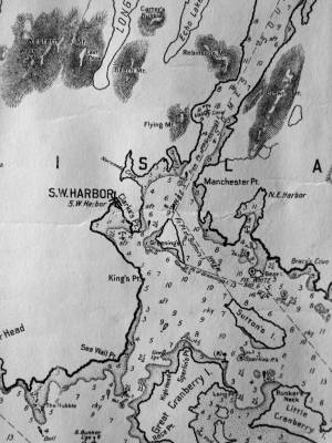
Chart G
Charles G. Hutchinson, Publisher
Private Collection
George W. Eldridge was a Boston-based publisher of charts, pilot books, and tide tables for yachtsmen cruising in the New York–New England region. Detail of the Mount Desert portion of a much larger chart.
Also filed under: Maps » // Northeast Harbor » // Somes Sound »
Chart
U.S. Coast Survey
Chart with key showing the route of an excursion on the sloop "Superior" out of Castine made by William H. Witherle, Lane, Stevens and friends during which Lane made several sketches of Mt. Desert scenery. The trip was chronicled by Witherle in his diary of 1852.
View related catalogue entries (6) »
Also filed under: "Superior" (Sloop) » // Castine » // Penobscot Bay » // Southwest Harbor » // Witherle, William Howe »
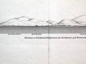
Illustration
"U.S. Coast Pilot, Atlantic Coast, Parts I–II." First edition. Published by Washington GPO, 1891
Folded plate between pp. 62 and 63
Also filed under: Bear Island » // Maps » // Northeast Harbor, Maine – Bear Island Lighthouse » // Southwest Harbor »
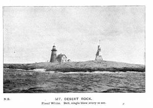
Photograph
From The Illustrated Coast Pilot with sailing directions. The Coast of New England from New York to Eastport, Maine including Bays and Harbors, published by N. L. Stebbins, Boston, Mass.
Also filed under: Mount Desert, Maine – Mount Desert Rock Light »
Wilson Museum, Castine, Maine.
Library of Congress Catalog Number 2011588006
1860 map, including census of towns.
Also filed under: Castine » // Maps » // Penobscot Bay »
Personal diary
Wilson Museum, Castine, Maine (A00060-1a-1h)
Description of an excursion taken by Joseph Stevens, Jr., Lane, Witherle, Samuel Adams, Jr., and George Tilden around the islands of Maine near Mt. Desert. The group hired the Sloop "Superior" which was owned by Pilot Getchell. In his diary, Witherle mentions multiple times that "Lane took a sketch" especially when the water was calm. Lane often stayed on board the boat, while the others went ashore.
Excerpts of the diary include:
August 16: "Lane has a knack for frying fish."
August 17: "leaving Lane to take a sketch, we took a climb."
August 19: "went to ascend one of the highest mountains. 3/4 the way up we had to wait – once in a while for Lane who with his crutches could not keep up with us – but got along faster than we thought possible . . .Lane got up about an hour after the rest of us."
The entire text is transcribed in an account published by the Wilson Museum.
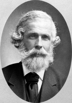
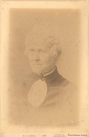
Joseph Lowe Stevens, Jr. (1823–1908) was Lane's closest friend and traveling companion. He was also executor of Lane's estate, and a tireless promoter of Lane's work. He was a supporter of abolition and animal welfare, and an active member of the Gloucester Lyceum. It was the Stevens family who encouraged Lane to make a print of Castine and who published and promoted it there Castine, from Hospital Island, 1855 (inv. 448). Joseph first worked as a dry goods salesman and in later life “engaged in the wholesale dry-goods and woollen trade on Summer St. Boston, travelling daily to and fro” on the train. (1)
Joseph's father, Dr. Joseph Lowe Stevens, Sr., was born in Andover, Massachusetts, and raised in Gloucester, Massachusetts. He married Dorothy Little of Castine, Maine, where the couple settled, and where Joseph Jr. was born in 1823. In the spring of 1840, at the age of seventeen, Joseph, Jr. left Maine and moved to Gloucester to work in his uncle’s Samuel Stevens' dry goods store and to live with his grandfather, Zachariah Stevens. Seven years later, Joseph, Jr. married his second cousin, Caroline Stevens Foster. The couple eventually had five children, one of whom died very young.
Like most of the educated population of the town, Joseph joined the Gloucester Lyceum shortly after arriving in town; the signature of John J. Piper appears next in the membership book; and the next after him was Fitz Henry Lane. (2) Joseph remained involved with the Gloucester Lyceum and Library for most of his life, acting as director for many years, and was the superintendent at the time it became incorporated as the Gloucester Lyceum and Sawyer Free Library.
Joseph also helped his father work on a history of Castine, and he was sufficiently concerned about the welfare of animals to serve on the boards of three animal-aid societies. He became the secretary of the Society for the Prevention of Cruelty to Animals and the New England Humane Education Society, and treasurer of the Band of Mercy. (3) Joseph was committed to more than animal welfare; he involved himself in the Free Soil movement and the slavery debate, to the extent that he left Gloucester for Kansas in 1855 “to see for himself what was going on,” returning about two years later. (4)
Joseph L. Stevens, Jr. first became friends with Lane after the artist had returned from Boston and had set up a studio on Elm Stree. That same year, Joseph invited Lane to accompany him to Castine. It was the first of many such trips to the Maine coast, where Lane sketched and painted and visited with Joseph’s parents.
When Lane fell out with his brother-in-law, Joseph Stevens came to the rescue by purchasing the contested stone house from Lane and evicting the troublesome in-laws. He was also at Lane’s side when he died and was named as one of two executors in Lane’s will. In addition, he inherited two-thirds of the residual property of the estate.
Joseph’s wife Caroline died in 1886, and Joseph left Gloucester nine years later to marry Charlotte M. Todd of Milton. He remained there until his own death. He is buried in Oak Grove cemetery alongside Caroline and their infant son. Lane is also buried in their family plot.
– Stephanie Buck
(1) Joseph L. Stevens Jr., letter written as Superintendent of the Sawyer Free Library, for the 1876 Women’s Time Capsule. Gloucester Archives, CC195 and AS300.
(2) Gloucester Lyceum Records, vol. 1, 1830–1852.
(3) The New England Humane Education Society is not to be confused with the coastal lifesaving institution which was then known as the Massachusetts Humane Society. The Band of Mercy was associated with the Massachusetts SPCA.
(4) F. A. Sharf, "Fitz Hugh Lane: Visits to the Maine Coast, 1848–1855," Essex Institute Historical Collection 98, no. 2 (April 1962): 112.
n.d. Photograph Wilson Museum, Castine, Maine (a02156)
Also filed under: Historic Photographs »
Newsprint
Gloucester Daily Telegraph
Article by Joseph L. Stevens
"The beauties of this place [Maine] are well known and appreciated among artists. We heard of Bonfield and Williams who had reluctantly left but a short time before. Fishe had spent several weeks there. Champney and Kensett were then in another part of the island, and we have reason to believe that Church and some others were in the immediate vicinity–Lane who was with us, made good additions to his portfolio."
Personal journal
Wilson Museum, Castine, Maine
Box 2, F1 (A00772)
John Stevens was the younger brother of Joseph Stevens, and acquainted with Lane, spending time with him in Gloucester and at the family home in Castine. His journal, quoted below, includes reference to hunting plover and teal, school, sailing, local events. Mentions Castine mill, lighthouse, and block house.
"Friday [September] 17th: Cloudy all day. Wind N. blowing quite hard. A British Rig loaded with salt from Liverpool came into port last night. She run way up by the Monument and got aground. They kedged her off this P.M. and came down. She came in with one of these old English charts as her guide. They have the town set down on the Brooksville side, two miles + three quarters from the lighthouse."
"Wednesday [September] 22. . .Went down to the Indians Camp on the Back Cove. There were five camps of them."
Visits Gloucester from Castine:
"Wednesday [October] 27th. . .Left for Gloucester [from Boston] at 5 o'clock this P.M. arrived there safe + sound at 6 1/2 o'clock; went right down to the store and saw Joe. We then went up to his house and got supper.
"Thursday [October] 28th. At. Gloucester. Pleasant day. Went down to the "Cut" a gunning this morning before breakfast but saw no birds. Went out in the harbor this forenoon alone, had a fine sail but couldn't get a chance at any birds. Went out again this P.M. got down to East Point Light and the wind died all away, so I had to scull home."
"Friday 29th. Very pleasant day, went out in the harbor this morning with Joe. Took a walk this A.M. with "Lina", called on Mr. Lane + Doct. Hildreth. Joe + I went out in the harbor this P.M. I fired at some birds several times, but didn't get any. . . ."
Also filed under: Biographical information » // Bird Hunting » // Castine » // Castine – School » // Chronology » // Cut, The (Stacy Blvd.) » // Diaries / Ledgers / Etc. »
Newspaper
Gloucester Telegraph
"Ignatius Winter v. Joseph L. Stevens, Jr.—This was an action of tort brought by the plaintiff to recover damages for personal injury in ejecting him from his dwelling house, as the plaintiff claimed. Defendant justified his expulsion of the plaintiff on the ground that he expelled him from his own, the defendant's house, using no more force than was reasonably necessary to accomplish this."
Also filed under: Newspaper / Journal Articles » // Winter, Ignatius »
Samuel Sawyer Papers
Cape Ann Museum Library & Archives
Archive Collection
"Met Mr. Tuckerman the artist walking with Jos. Stevens."
Also filed under: Diaries / Ledgers / Etc. » // Sawyer, Samuel » // Tuckerman, Stephen Salisbury »
Newspaper
Letter to the editor: "Fitz H. Lane's will and gift of the Old Fort painting in the Town Hall, sketched in 1859, from T. Sewell Lancaster and Joseph L. Stevens, executors."
Reply from Selectmen: "Mr. Lane was much esteemed by his townsmen not only for his skill as an artist, but also for his character, as a gentleman of Honor and Integrity."
Also filed under: Biographical information » // Funeral & Burial » // Lancaster, T. Sewall » // Newspaper / Journal Articles »
Handwritten list
Wilson Museum, Castine, Maine (A00787-1a-1d)
Also filed under: Castine » // Castine – Witherle & Co.'s Store » // Lithography (Sales & Exhibitions) » // Noyes, Samuel » // Publications » // Witherle, William Howe »
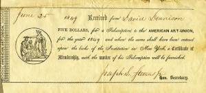
Printed paper receipt with handwritten entries by Joseph L. Stevens, Jr.
Cape Ann Museum, Gloucester, Mass.
Also filed under: New York – American Art Union »
Letter regarding the burning of the packet ship "Boston"
Cape Ann Museum, Gloucester, Mass.
"Dear Sir, Agreeable to your request that I would write something to attach to the picture in your possession of the Burning of the Packet Ship Boston in 1830, your object I suppose more fully to establish the fact that it is really one of the early productions of our fellow townsman and afterward most distinguished artist Fitz H. Lane.
The picture was drawn the same year by Mr. Lane from a sketch I made soon after the disaster aided by one of the passengers S.S. Osgood Esq. afterward a distinguished portrait painter. Mr. Lane had made not reputation of course at this time as an artist. And probably had received no instruction. It afforded me great pleasure to present this picture to you who was so devoted to him, knowing full well tho nothing very great of itself would be highly appreciative [...] as the early work of that [...] particular friend."
Also filed under: "Boston" (Packet Ship) » // Knight, Elias Davis » // Letters »
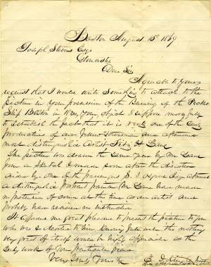
Letter
Cape Ann Museum Library & Archive, Gloucester, Mass.
". . . will fully appreciate all that I have done in my garden, in ornamenting it, with flowers and plants, Rustic Arbours and Statues, and I only wish that you could be here to witness and enjoy his [Dr. J. L. Stevens] expressions of delight and interest, when a new flower attracts his attention, or some beauty of arrangement meets his eye. Samuel [B. Stevens of Castine] he tells me came up with the expectation of going on a voyage to Australia, but when he arrived in Boston he found the vessel with her compliment of men, and it is very uncertain if he goes in her. Your Mother and all at home are well. I yesterday made a sketch of Stage Fort and the surrounding scenery, from the water. Piper has given me an order for a picture from this point of view, to be treated as a sunset. I shall try to make something out of it, but it will require some management, as there is no foreground but water and vessels. One o’clock, it is very hot, the glass indicates 84° in my room, with the windows all open and a light breeze from the east, this is the warmest day . . .
. . . than devoting it to you. Since writing you last I have painted but one picture worth talking about and that one I intend for you if you should be pleased with it. It is a View of the beach between Stage Fort and Steep bank including Hovey’s Hill and residence, Fresh water cove and the point of land with the lone pine tree. Fessenden’s house, likewise comes into the picture. The effect is a mid day light with a cloudy sky, a patch of sunlight is thrown across the beach and the breaking waves, an old vessel lies stranded on the beach with two or three figures, there are a few vessels in the distance and the Field rocks likewise show at the left of the picture. I think you will be pleased with this picture, for it is a very picturesque scene especially the beach, as there are many rocks which come in to destroy the monotony of a plain sand beach, and I have so arranged the light and shade that the effect I think is very good indeed, however you will be better able to judge of that when you see it, the size is 20 x 33. . ."
Letter
Castine Historical Society, Maine
"[John] says Charles proposes to come down on Saturday—to return on Monday—so that may be so—I think of defering sending the pictures till then—it has been my intention to have sent them tomorrow. [??] went away on Monday last before I had time to have them boxed. Mr. Noyes will see to that. The have been, for a day or two, in Witherle & Co.'s store, where they were much admired—& a little remarkable, among the visitors there yesterday was Mr. King—the son of the Keeper of the Light—who was engaged in catching herring while you was at the Rock. He was very much pleased—thought it as natural as life—as it was to his recollection—having only left there a week since. He observed that he would not have believed Mr. Lane had so much in him. In case Charles does not come on Saturday how shall I direct the box—for I shall send it by express to Boston—I don't remember any thing was said about that. I hope you will come over to Owl's Head, as proposed—if so, you & Lane must come & spend one night at least. Our two teacher boarders came in the boat that took you away—but we can continue to accommodate some way or other. Mary is to leave on Monday next."
1903 Four-page letter Collection of the Cape Ann Museum Library & Archive, Gloucester, Mass.
"[The painting] is offered you for $150 on as long time and in as many notes at 3% interest as you choose. . . I believe this to be the only important painting of Gloucester Harbor that Lane never duplicated. . . .Returning from a Gloucester visit while I was still under the roof there, father brought a print of Lane's first Gloucester view, bought of the artist at his Tremont Temple studio in Boston. An extra dollar had been paid for coloring it. For a few years it was a home delight.. . .I had been a few years in Gloucester when Lane began to come, for part of the time a while, if I remember rightly. He painted in his brother's house, "up in town" it then was. I recall visits there to see his pictures. But it was long after, that I could claim more than a simple speaking acquaintance. The Stacys were very kind, aiding him as time went on in selling paintings by lot. I invested in a view of Gloucester from Rocky Neck, thus put on sale at the old reading room, irreverently called "Wisdom Hall." And they bought direct of him to some extent, before other residents. Lane was much my senior and yet we gradually drifted together. Our earliest approach to friendship was after his abode began in Elm Street as an occupant of the old Prentiss [sic-corrected Stacy] house, moved there from Pleasant. I was a frequenter of this studio to a considerable extent, yet little compared with my intimacy at the next and last in the new stone house on the hill. Lane's art books and magazines were always at my service and a great inspiration and delight—notably the London Art Journal to which he long subscribed. I have here a little story to tell you. A Castine man came to Gloucester on business that brought the passing of $60 through my hands at 2 1/2 % commission. I bought with the $1.50 thus earned Ruskin's Modern Painters, my first purchase of an artbook. I dare say no other copy was then owned in town. . . .Lane was frequently in Boston, his sales agent being Balch who was at the head of his guild in those days. So in my Boston visits – I was led to Balch's fairly often – the resort of many artists and the depot of their works. Thus through, Lane in various ways I was long in touch with the art world, not only of New England but of New York and Philadelphia. I knew of most picture exhibits and saw many. The coming of the Dusseldorf Gallery to Boston was an event to fix itself in one's memory for all time. What talks of all these things Lane and I had in his studio and by my fireside!
For a long series of years I knew nearly every painting he made. I was with him on several trips to the Maine coast where he did much sketching, and sometimes was was [sic] his chooser of spots and bearer of materials when he sketched in the home neighborhood. Thus there are many paintings whose growth I saw both from brush and pencil. For his physical infirmity prevented his becoming an out-door colorist."
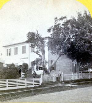
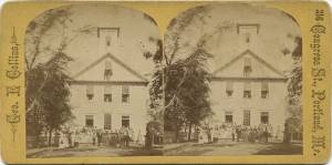
1871 Photograph Maine Historic Preservation Commission (2000.24)
Also filed under: Castine – Stevens Home » // Historic Photographs » // Stevens, Joseph, Sr. and Dorothy Little »
Single sheet, writing both sides
Cape Ann Museum Library & Archives, Gloucester, Mass.
"My dear Sir,
I hope you will not attribute the delay in acknowledging the receipt of your splendid, and most unexpected Gift to a want of a due appreciation of it. Many reasons have consipired to prevent my doing it – unnecessary to repeat. But I can no longer defer the expressions of our warmest acknowledgements for a present in itself so valuable, and endeared to us by many associations, as a representation of scenery often admired, and which I have many times wished could be transferred to canvas, although vary far from thinking that wish would ever be gratified. You must premit me, however, to say that the Painting, valuable as it is as a work of Art, and pleased as I may be as the possessor of it, is less appreciated by us than the delicate and very generous manner in which its acceptance has been tendered. My love of Art, to which you do politely allude, I am sensible has only wanted opportunity of indulgence to have amounted to a passion. From my earliest days I have wished for opportunities to visit places, where that desire could be gratified, and my reading has only had the effect of increasing my regrets for the want of them, and of encouraging envy for those more fortunate - I feel, too, under great obligations for the Drawing of the "Siege"(1) – I had no expectations you could have produced anything so good from so rough a copy. I shall have it framed for presentation and future reference. Several gentlemen who have called in to see the painting have expressed a desire to have a drawing from you of our town, similar to yours of Gloucester, which they much admire, and of lithographs, I have no doubts copies enough could be disposed of to remunerate you. That of Homans you are aware is feebly drawn, & still worse printed. I feel desirous myself it should be done, if it suits your wishes. There are several points of view, which you did not see, & to which it will be my pleasure, next summer, to carry you. I know many of our citizens would be gratified to have this done by you. Our house we shall expect to be your home, and if, as you suggested in Gloucester, you should come in your Boat, this place could be made the rendezvous, from whence you could start to any place that convenience & inclination might dictate – . . . Permit me again to tender acknowledgements for the picture. It hangs in our parlor, & I never come in to the house, without looking in to see it, & can never cease to feel grateful for your generosity and politeness. "
(1) Joseph Stevens was very interested the Revolutionary war event known as the "Penobscot Expedition" or the "Siege of Castine" by the British on July 25, 1779. In 1852 he handwrote an account of it and many articles are in the family's scrapbook at the Wilson Museum in Castine.
View related catalogue entries (2) »
Also filed under: Castine » // Homan, S.V. » // Letters » // Stevens, Joseph, Sr. and Dorothy Little »
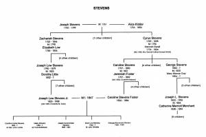
Appendix G: Family Trees, in Sarah Dunlap and Stephanie Buck, Fitz Henry Lane: Family and Friends (Gloucester, MA: Church & Mason Publishing; in association with the Cape Ann Historical Museum, 2007), 164–66.
Also filed under: Stevens, Caroline Foster » // Stevens, Joseph, Sr. and Dorothy Little »
Personal notebook
Wilson Museum, Castine, Maine
Note about historical importance of this Castine landmark: "On Saturday afternoon, August 11, 1855, with my friend the marine artist Fitz. H. Lane of Gloucester" visited Trask's Rock
Also filed under: Biographical information »
October 3, 1865 Essex County Probate Records, Volume 424, Leaves 34 & 35
The will disposed of Lane's property (including watch and diamond breast pin), his monetary assets, and gave to the city of Gloucester a painting of the Old Fort. Joseph Stevens, Jr. and T. Sewall Lancaster were named executors. It was signed by Lane on March 10, 1865.
Also filed under: Chronology » // Davidson, Dr. Herman Elvas » // Documents / Objects » // Funeral & Burial » // Galacar, Elizabeth » // Lancaster, T. Sewall » // Mellen, Mary Blood » // Page, Eben » // Stevens, Caroline Foster » // Wilbur, Horace B. »
Personal diary
Wilson Museum, Castine, Maine (A00060-1a-1h)
Description of an excursion taken by Joseph Stevens, Jr., Lane, Witherle, Samuel Adams, Jr., and George Tilden around the islands of Maine near Mt. Desert. The group hired the Sloop "Superior" which was owned by Pilot Getchell. In his diary, Witherle mentions multiple times that "Lane took a sketch" especially when the water was calm. Lane often stayed on board the boat, while the others went ashore.
Excerpts of the diary include:
August 16: "Lane has a knack for frying fish."
August 17: "leaving Lane to take a sketch, we took a climb."
August 19: "went to ascend one of the highest mountains. 3/4 the way up we had to wait – once in a while for Lane who with his crutches could not keep up with us – but got along faster than we thought possible . . .Lane got up about an hour after the rest of us."
The entire text is transcribed in an account published by the Wilson Museum.
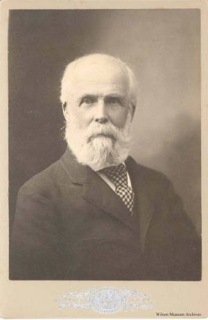
Joseph L. Stevens, Sr. was born in Gloucester, Massachusetts on August 15, 1790. He attended Andover and then Harvard, from which he graduated in 1810. He was also part of the medical class of 1814. In 1819, an Andover classmate of his—a Dr. Gage—was leaving Castine, Maine, and recommended that Stevens move to Castine to start his practice. Stevens did so, and in 1821, he married Dorothy Little of Castine. Their son Joseph moved back to Gloucester, and for several summers, he traveled back to Castine to visit his parents and siblings, bringing Lane with him. After Joseph, Sr.'s death, Dorothy moved to Gloucester in 1881. She wanted to be near her sons, Joseph, Jr. and Dr. George B. Stevens, both of whom were living in Gloucester at that time. (1)
(1) Sarah Dunlap and Stephanie Buck, Fitz Henry Lane: Family and Friends (Gloucester, MA: Church & Mason Publishing; in association with the Cape Ann Historical Museum, 2007), 76.
Newspaper clipping from scrapbook with clippings from other dates
Cape Ann Museum Library & Archive
References Mr. Joseph Stevens as secretary of the American Art-Union, having provided Transactions for 1848, containing 'two paintings by Fitz Henry Lane Esq., of this town, viz. "Rockport Beach" and "Ipswich Bay."'
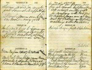
Personal diary
Castine Historical Society
From July 25-August 16,1848, Castine native Noah Brooks made a return visit to his hometown. He was eighteen at the time, and had been living in Boston. In his diary, there is no mention of Lane, but he recounts Castine gossip, and writes about visits with the Stevens and Witherle familes, accounts of swimming in Back Cove, and reading Wuthering Heights. The daily arrival of "the boat" (the "T.F.S." or the "Secor")—the way it was anticipated and observed by Castine residents—is notable.
Also filed under: "T. F. Secor" (Steamboat) » // Brooks, Noah » // Castine » // Diaries / Ledgers / Etc. » // Steamers » // Witherle, William Howe »
Letter
Cape Ann Museum, Gloucester, Mass.
Also filed under: "General Gates" (New England Boat; Casco Bay Boat) » // Castine » // Chronology » // Letters »
Letter
Cape Ann Museum Library & Archives, Gloucester, Mass.
Thanks for "View of Owl's Head", a moonlight scene: "Mr. Lane, Dear Sir, when I expressed to you, during your visit to us, the last summer, my admiration of moonlight scenes, I did not for a moment suppose that I should ever become the possessor of one, and that so beautiful as "The View of Owls Head," which you have so kindly, and in so delicate a manner presented to me, and for which, I now beg you to accept my heartfelt thanks, also, be assured, if your pleasure in giving has been half equal to mine in receiving, you have been amply repaid for your kindness, and I alone, am the debtor. . . ."
View related catalogue entries (2) »
Also filed under: Castine – Stevens Home » // Chronology » // Letters » // Owl's Head » // Rockland Harbor, Maine – Owl's Head Light »
Letter
Castine Historical Society, Maine
Writing to her son, Joseph, about selling the house. Also, "Mrs. Nellie Johnson of (Glap?) borough and daughter of Bob Perkins was in, and is very anxious to get one of those pictures of Castine, her husband has always wanted one as we have none, I thought possibly you or Edward or George might have an extra one and told her I would inquire as I was writing. She expressed great pleasure at the thought of my doing so . . . if you have one you can bring or send it with the price and she will gladly take the engraving"
Also filed under: Castine – Stevens Home »
Letter
Cape Ann Museum Library & Archive, Gloucester, Mass.
". . . will fully appreciate all that I have done in my garden, in ornamenting it, with flowers and plants, Rustic Arbours and Statues, and I only wish that you could be here to witness and enjoy his [Dr. J. L. Stevens] expressions of delight and interest, when a new flower attracts his attention, or some beauty of arrangement meets his eye. Samuel [B. Stevens of Castine] he tells me came up with the expectation of going on a voyage to Australia, but when he arrived in Boston he found the vessel with her compliment of men, and it is very uncertain if he goes in her. Your Mother and all at home are well. I yesterday made a sketch of Stage Fort and the surrounding scenery, from the water. Piper has given me an order for a picture from this point of view, to be treated as a sunset. I shall try to make something out of it, but it will require some management, as there is no foreground but water and vessels. One o’clock, it is very hot, the glass indicates 84° in my room, with the windows all open and a light breeze from the east, this is the warmest day . . .
. . . than devoting it to you. Since writing you last I have painted but one picture worth talking about and that one I intend for you if you should be pleased with it. It is a View of the beach between Stage Fort and Steep bank including Hovey’s Hill and residence, Fresh water cove and the point of land with the lone pine tree. Fessenden’s house, likewise comes into the picture. The effect is a mid day light with a cloudy sky, a patch of sunlight is thrown across the beach and the breaking waves, an old vessel lies stranded on the beach with two or three figures, there are a few vessels in the distance and the Field rocks likewise show at the left of the picture. I think you will be pleased with this picture, for it is a very picturesque scene especially the beach, as there are many rocks which come in to destroy the monotony of a plain sand beach, and I have so arranged the light and shade that the effect I think is very good indeed, however you will be better able to judge of that when you see it, the size is 20 x 33. . ."
Letter
Castine Historical Society, Maine
"[John] says Charles proposes to come down on Saturday—to return on Monday—so that may be so—I think of defering sending the pictures till then—it has been my intention to have sent them tomorrow. [??] went away on Monday last before I had time to have them boxed. Mr. Noyes will see to that. The have been, for a day or two, in Witherle & Co.'s store, where they were much admired—& a little remarkable, among the visitors there yesterday was Mr. King—the son of the Keeper of the Light—who was engaged in catching herring while you was at the Rock. He was very much pleased—thought it as natural as life—as it was to his recollection—having only left there a week since. He observed that he would not have believed Mr. Lane had so much in him. In case Charles does not come on Saturday how shall I direct the box—for I shall send it by express to Boston—I don't remember any thing was said about that. I hope you will come over to Owl's Head, as proposed—if so, you & Lane must come & spend one night at least. Our two teacher boarders came in the boat that took you away—but we can continue to accommodate some way or other. Mary is to leave on Monday next."
Also filed under: Biographical information » // Castine – Witherle & Co.'s Store » // Castine, Maine – 1856 Witherle & Co. » // Chronology » // Letters » // Noyes, Samuel » // Stevens, Joseph, Jr. » // Witherle, William Howe »
1903 Four-page letter Collection of the Cape Ann Museum Library & Archive, Gloucester, Mass.
"[The painting] is offered you for $150 on as long time and in as many notes at 3% interest as you choose. . . I believe this to be the only important painting of Gloucester Harbor that Lane never duplicated. . . .Returning from a Gloucester visit while I was still under the roof there, father brought a print of Lane's first Gloucester view, bought of the artist at his Tremont Temple studio in Boston. An extra dollar had been paid for coloring it. For a few years it was a home delight.. . .I had been a few years in Gloucester when Lane began to come, for part of the time a while, if I remember rightly. He painted in his brother's house, "up in town" it then was. I recall visits there to see his pictures. But it was long after, that I could claim more than a simple speaking acquaintance. The Stacys were very kind, aiding him as time went on in selling paintings by lot. I invested in a view of Gloucester from Rocky Neck, thus put on sale at the old reading room, irreverently called "Wisdom Hall." And they bought direct of him to some extent, before other residents. Lane was much my senior and yet we gradually drifted together. Our earliest approach to friendship was after his abode began in Elm Street as an occupant of the old Prentiss [sic-corrected Stacy] house, moved there from Pleasant. I was a frequenter of this studio to a considerable extent, yet little compared with my intimacy at the next and last in the new stone house on the hill. Lane's art books and magazines were always at my service and a great inspiration and delight—notably the London Art Journal to which he long subscribed. I have here a little story to tell you. A Castine man came to Gloucester on business that brought the passing of $60 through my hands at 2 1/2 % commission. I bought with the $1.50 thus earned Ruskin's Modern Painters, my first purchase of an artbook. I dare say no other copy was then owned in town. . . .Lane was frequently in Boston, his sales agent being Balch who was at the head of his guild in those days. So in my Boston visits – I was led to Balch's fairly often – the resort of many artists and the depot of their works. Thus through, Lane in various ways I was long in touch with the art world, not only of New England but of New York and Philadelphia. I knew of most picture exhibits and saw many. The coming of the Dusseldorf Gallery to Boston was an event to fix itself in one's memory for all time. What talks of all these things Lane and I had in his studio and by my fireside!
For a long series of years I knew nearly every painting he made. I was with him on several trips to the Maine coast where he did much sketching, and sometimes was was [sic] his chooser of spots and bearer of materials when he sketched in the home neighborhood. Thus there are many paintings whose growth I saw both from brush and pencil. For his physical infirmity prevented his becoming an out-door colorist."
View related catalogue entries (4) »
Also filed under: Balch, William Y. » // Castine » // Drawing Manuals » // Residences » // Stacy, Mr. and Mrs. John Hancock » // Stevens, Joseph, Jr. » // Tremont Temple »
Personal diary
Wilson Museum, Castine, Maine
Monday, July 13, 1857: "Spent the Day in visiting round Gloucester - Mr. Lane's house, studio + garden, the cemetaries, Eastern Point, +c - the town has increased wonderfully since my youth."
Friday, December 12, 1862: "Went down to Rockport in co of Mr. Lane and Lancaster"
Thursday, August 27, 1863: "Joseph & Mr. Lane came today"
Tuesday, September 1, 1863: "Joseph & Mr. Lane went in stage to Bucksport, for home"
Also filed under: Biographical information » // Chronology » // Diaries / Ledgers / Etc. »
1871 Photograph Maine Historic Preservation Commission (2000.24)
Also filed under: Castine – Stevens Home » // Historic Photographs » // Stevens, Joseph, Jr. »
Single sheet, writing both sides
Cape Ann Museum Library & Archives, Gloucester, Mass.
"My dear Sir,
I hope you will not attribute the delay in acknowledging the receipt of your splendid, and most unexpected Gift to a want of a due appreciation of it. Many reasons have consipired to prevent my doing it – unnecessary to repeat. But I can no longer defer the expressions of our warmest acknowledgements for a present in itself so valuable, and endeared to us by many associations, as a representation of scenery often admired, and which I have many times wished could be transferred to canvas, although vary far from thinking that wish would ever be gratified. You must premit me, however, to say that the Painting, valuable as it is as a work of Art, and pleased as I may be as the possessor of it, is less appreciated by us than the delicate and very generous manner in which its acceptance has been tendered. My love of Art, to which you do politely allude, I am sensible has only wanted opportunity of indulgence to have amounted to a passion. From my earliest days I have wished for opportunities to visit places, where that desire could be gratified, and my reading has only had the effect of increasing my regrets for the want of them, and of encouraging envy for those more fortunate - I feel, too, under great obligations for the Drawing of the "Siege"(1) – I had no expectations you could have produced anything so good from so rough a copy. I shall have it framed for presentation and future reference. Several gentlemen who have called in to see the painting have expressed a desire to have a drawing from you of our town, similar to yours of Gloucester, which they much admire, and of lithographs, I have no doubts copies enough could be disposed of to remunerate you. That of Homans you are aware is feebly drawn, & still worse printed. I feel desirous myself it should be done, if it suits your wishes. There are several points of view, which you did not see, & to which it will be my pleasure, next summer, to carry you. I know many of our citizens would be gratified to have this done by you. Our house we shall expect to be your home, and if, as you suggested in Gloucester, you should come in your Boat, this place could be made the rendezvous, from whence you could start to any place that convenience & inclination might dictate – . . . Permit me again to tender acknowledgements for the picture. It hangs in our parlor, & I never come in to the house, without looking in to see it, & can never cease to feel grateful for your generosity and politeness. "
(1) Joseph Stevens was very interested the Revolutionary war event known as the "Penobscot Expedition" or the "Siege of Castine" by the British on July 25, 1779. In 1852 he handwrote an account of it and many articles are in the family's scrapbook at the Wilson Museum in Castine.
View related catalogue entries (2) »
Also filed under: Castine » // Homan, S.V. » // Letters » // Stevens, Joseph, Jr. »
n.d. Photograph Wilson Museum, Castine, Maine (a02153)
Also filed under: Historic Photographs »
n.d. Photograph Wilson Museum, Castine, Maine (a02152)
Also filed under: Historic Photographs »
Appendix G: Family Trees, in Sarah Dunlap and Stephanie Buck, Fitz Henry Lane: Family and Friends (Gloucester, MA: Church & Mason Publishing; in association with the Cape Ann Historical Museum, 2007), 164–66.
Also filed under: Stevens, Caroline Foster » // Stevens, Joseph, Jr. »
Bouvé and Sharp, Lithographers, 221 Washington Street, Boston
Boston Athenaeum
Looking at Castine from Hospital Island. Joseph Stevens, Sr. mentions this print in the letter he wrote to Lane encouraging Lane to make a lithograph of Castine.
Also filed under: Bouvé & Sharp, Lith. – Boston » // Castine » // Homan, S.V. »
Marks: Inscribed upper left (in red ink): 24 [numbering system used by curator A. M. Brooks upon Samuel H. Mansfield's donation of the drawings to the Cape Ann Museum]