An online project under the direction of the CAPE ANN MUSEUM
Catalogue Entry
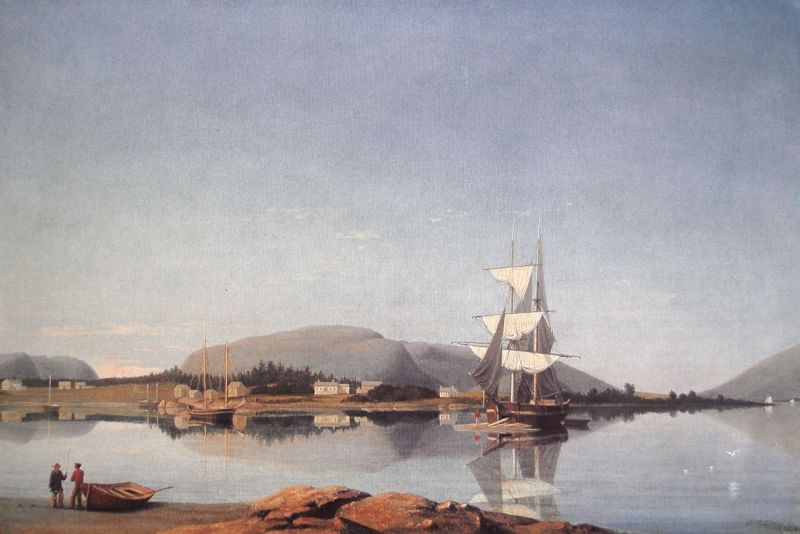
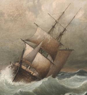
Lane’s depictions of lumber brigs (which were actually half-brigs), while not as common as lumber schooners, are particularly informative in two of his paintings. View of Southwest Harbor, Maine: Entrance to Somes Sound, 1852 (inv. 260) depicts the loading of a lumber brig while anchored in Southwest Harbor, Maine. Lane made the drawing for this scene from on board the sloop Superior, looking from the southern side of the harbor, north to Clarke’s Point.
Somes Sound lies just beyond Clarke’s Point and Greening’s Island lies beyond the right margin. The mountains flanking the sound loom in the background. It is mid-afternoon and the anchored lumber brig is loading the last of the planks brought to it on a log raft. The open bow port, necessary for getting long planks into the hold, will be securely covered and made watertight for the voyage to come. Once the hold is filled, several raft-loads of lumber will be needed for the deck load, which could reach six feet or more in height for a deck-load on a vessel this size. Extra care must be taken to lash the deck cargo down securely with rope and short pieces of lumber lashed vertically along the sides - also horizontally across the top of the deck load - to prevent shifting and loss of cargo.
This scene depicts the late afternoon of a calm summer day on the Maine Coast, which will be followed by cool night air and a heavy morning dew. To prevent the cotton canvas sails from getting soaked and subject to rot, they are allowed to “hang in the gear”- the staysails partially hoisted and the square sails clewed-up in loose bights. This was done routinely in calm weather to permit ventilation and drying while at anchor or wharfside, and can be seen in many of Lane’s port paintings, wherever he went.
Twilight on the Kennebec, 1849 (inv. 258), one of Lane’s earliest depictions of Maine, is not a coastal scene, but of the lower Kennebec River, a tidal river from its mouth to as far north as Augusta. As in View of Southwest Harbor, Maine: Entrance to Somes Sound, 1852 (inv. 260), the brig’s hold will be loaded through a bow port, the boards being too long to be passed down through the hatch on deck. Once the hold is filled, raft loads of lumber will be brought alongside and carefully stowed on deck. All deck space, rail to rail, from main mast to fore mast, will be carefully stacked with lumber to a height of six feet or more. Due to its exposed location, the deck load must be secured with boards and lashings as described previously, to prevent shifting and loss of cargo in heavy weather.
– Erik A. R. Ronnberg, Jr.
- Vessel Types
: - Brig »
- Brig (Half) »
- Maine Buildings & Locales
: - New England Locales
: - Maine »
Historical Materials
Newsprint
Gloucester Daily Telegraph
Article by Joseph L. Stevens
"The beauties of this place [Maine] are well known and appreciated among artists. We heard of Bonfield and Williams who had reluctantly left but a short time before. Fishe had spent several weeks there. Champney and Kensett were then in another part of the island, and we have reason to believe that Church and some others were in the immediate vicinity–Lane who was with us, made good additions to his portfolio."
19 x 28 in.
Survey of the Coast of the United States, Washington, D.C.
Filed under: Bear Island » // Maps » // Northeast Harbor, Maine – Bear Island Lighthouse » // Somes Sound »
Mount Desert "displays several U-shaped valleys, almost perfectly parallel and trending a bit east of south; Somes Sound, nearly dividing the island in two, is of particular interest because it is a fjord, a valley cut much deeper than sea level by a glacier that extended an unknown distance out to sea. The Valley was later filled by the sea when the meltwater from the wasting ice raised sea level to its present elevation."
Abraham Somes is alleged to have made seasonal fishing trips to Somes Sound as early as 1755, though he did not begin the process of settlement until 1761. He removed his family through the Head of the Sound in 1762 and erected a sawmill. The Sound and the village bear his name. Through extended family kinships, the Somes family would be connected to the sawmill families of Flye of Union River and the Herrick's of Mount Desert, Sedgwick, and Penobscot.
– Mark Honey
References:
Honey, Mark E, "King Pine, Queen Spruce, Jack Tar," An Intimate History of Lumbering on the Union River, Volumes 1-5.
Kendall, David L, "Glaciers & Granite," A Guide to Maine's Landscape and Geology, Downeast Books, Camden, 1987
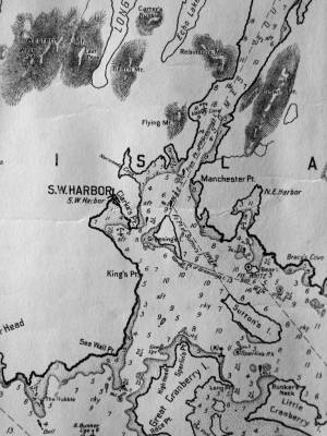
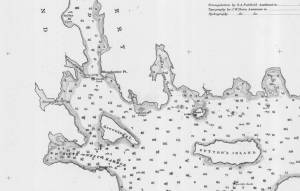
Chart G
Charles G. Hutchinson, Publisher
Private Collection
George W. Eldridge was a Boston-based publisher of charts, pilot books, and tide tables for yachtsmen cruising in the New York–New England region. Detail of the Mount Desert portion of a much larger chart.
Also filed under: Maps » // Mount Desert Island & Rock » // Northeast Harbor »
19 x 28 in.
Survey of the Coast of the United States, Washington, D.C.
Also filed under: Bear Island » // Maps » // Northeast Harbor, Maine – Bear Island Lighthouse »
Personal diary
Wilson Museum, Castine, Maine (A00060-1a-1h)
Description of an excursion taken by Joseph Stevens, Jr., Lane, Witherle, Samuel Adams, Jr., and George Tilden around the islands of Maine near Mt. Desert. The group hired the Sloop "Superior" which was owned by Pilot Getchell. In his diary, Witherle mentions multiple times that "Lane took a sketch" especially when the water was calm. Lane often stayed on board the boat, while the others went ashore.
Excerpts of the diary include:
August 16: "Lane has a knack for frying fish."
August 17: "leaving Lane to take a sketch, we took a climb."
August 19: "went to ascend one of the highest mountains. 3/4 the way up we had to wait – once in a while for Lane who with his crutches could not keep up with us – but got along faster than we thought possible . . .Lane got up about an hour after the rest of us."
The entire text is transcribed in an account published by the Wilson Museum.
View related catalogue entries (6) »
Also filed under: "Superior" (Sloop) » // Adams, Samuel, Jr. » // Biographical information » // Blue Hill » // Castine » // Chronology » // Diaries / Ledgers / Etc. » // Mount Desert Island & Rock » // Stevens, Joseph, Jr. » // Tilden, George » // Witherle, William Howe »
Southwest Harbor and Northeast Harbor flank Somes Sound of Mount Desert. The harbor is shared by two small villages, Manset, to the south, and Southwest Harbor and Clark Point to the north.The community often sent fishing vessels to the Labrador fleet. The swelling tide of artists, sightseers, philosophers, and pilgrims in the 1830s, '40s, and '50s would inspire such entrepreneurs as Deacon Henry H. Clark of Southwest Harbor, a shipwright, to build hotels to accommodate the travelers. This was a growth industry would sustain the prosperity of the island communities and their small farms in the years after the Civil War.
Southwest Harbor, which included Tremont until 1848, sent six schooners averaging 58 tons with the Labrador fleet in 1839. The smallest of these vessels was the 35 ton "Four Sisters" which could not have exceeded 50 feet. The Labrador fishery was ideal for such a small craft, for it allowed vessels to anchor in safe harbors, unbending their sails, and setting their men adrift in small boats near the shore. This practice would continue into the 1860s. These small vessels were ideal for men with limited capital who could easily afford to build and maintain these small vessels. More often than not, the crew would consist of a father and his sons, or all of the able-bodied men living in a small island community.
The British raided what is now Southwest Harbor in 1775 and attacked the home of John Manchester. The British killed or stole the livestock, took all of the winter provisions, and returned to the westward on board the "Falmouth Packet," but not before they told Mrs. Manchester that she could starve for all they cared. John Bunker, Manchester's brother-in-law, paddled his canoe westward in pursuit of the marauding British. He found them on the Sheepscot River at Wiscasset, and the "Falmouth Packet" at anchor with her crew on shore. He cut the lines in the dark of night, let the schooner drift with the tide, and then made sail, heading back to Mount Desert. The supplies were badly needed, as Downeast Maine was caught in the grip of a British embargo and families were starving. The supplies would carry the settlers through the winter. The British would come calling again on August 8, 1814, aboard the sloop of war "Tenados," and lost seven soldiers in a skirmish off Clark's Point. Capt. Benjamin Spurling of Cranberry Isle, whose grandson would be awarded the Medal of Honor after the Civil War, was in the thick of fighting with a ragtag band of fishermen who could only loosely be called a militia. Capt. Spurling would command a privateer during the war.
– Mark Honey
References:
Duncan, Roger F, "Coastal Maine, A Maritime History," WW Norton & Company, New York, 1992
O'Leary, Wayne M, "Maine Sea Fisheries," The Rise and Fall of a Native Industry, 1830-1890, Northeastern University Press, Boston, 1996.
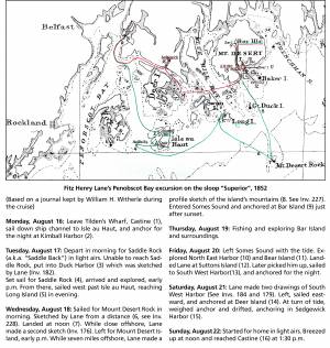
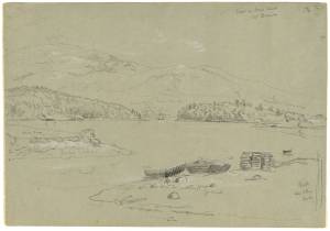
Chart
U.S. Coast Survey
Chart with key showing the route of an excursion on the sloop "Superior" out of Castine made by William H. Witherle, Lane, Stevens and friends during which Lane made several sketches of Mt. Desert scenery. The trip was chronicled by Witherle in his diary of 1852.
View related catalogue entries (6) »
Also filed under: "Superior" (Sloop) » // Castine » // Mount Desert Island & Rock » // Penobscot Bay » // Witherle, William Howe »
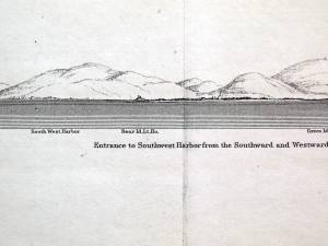
Illustration
"U.S. Coast Pilot, Atlantic Coast, Parts I–II." First edition. Published by Washington GPO, 1891
Folded plate between pp. 62 and 63
Also filed under: Bear Island » // Maps » // Mount Desert Island & Rock » // Northeast Harbor, Maine – Bear Island Lighthouse »
In general, brigs were small to medium size merchant vessels, generally ranging between 80 and 120 feet in hull length. Their hull forms ranged from sharp-ended (for greater speed; see Brig "Antelope" in Boston Harbor, 1863 (inv. 43)) to “kettle-bottom” (a contemporary term for full-ended with wide hull bottom for maximum cargo capacity; see Ships in Ice off Ten Pound Island, Gloucester, 1850s (inv. 44) and Boston Harbor, c.1850 (inv. 48)). The former were widely used in the packet trade (coastwise or transoceanic); the latter were bulk-carriers designed for long passages on regular routes. (1) This rig was favored by Gloucester merchants in the Surinam Trade, which led to vessels so-rigged being referred to by recent historians as Surinam brigs (see Brig "Cadet" in Gloucester Harbor, late 1840s (inv. 13) and Gloucester Harbor at Dusk, c.1852 (inv. 563)). (2)
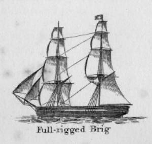
Brigs are two-masted square-rigged vessels which fall into three categories:
Full-rigged brigs—simply called brigs—were fully square-rigged on both masts. A sub-type—called a snow—had a trysail mast on the aft side of the lower main mast, on which the spanker, with its gaff and boom, was set. (3)
Brigantines were square-rigged on the fore mast, but set only square topsails on the main mast. This type was rarely seen in America in Lane’s time, but was still used for some naval vessels and European merchant vessels. The term is commonly misapplied to hermaphrodite brigs. (4)
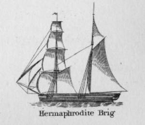
Hermaphrodite brigs—more commonly called half-brigs by American seamen and merchants—were square-rigged only on the fore mast, the main mast being rigged with a spanker and a gaff-topsail. Staysails were often set between the fore and main masts, there being no gaff-rigged sail on the fore mast.
– Erik Ronnberg
References:
1. Howard I. Chapelle, The National Watercraft Collection (Washington, DC: Smithsonian Institution, 1960), 64–68.
2. Alfred Mansfield Brooks, Gloucester Recollected: A Familiar History (Gloucester, MA: Peter Smith, 1974), 62–74. A candid and witty view of Gloucester’s Surinam Trade, which employed brigs and barks.
3. R[ichard] H[enry] Dana, Jr., The Seaman's Friend (Boston: Thomas Groom & Co., 1841. 13th ed., 1873), 100 and Plate 4 and captions; and M.H. Parry, et al., Aak to Zumbra: A Dictionary of the World's Watercraft (Newport News, VA: The Mariners’ Museum, 2000), 95.
4. Parry, 95, see Definition 1.
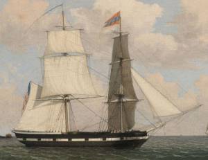
Oil on canvas
17 1/4 x 25 3/4 in.
Cape Ann Museum, Gloucester, Mass., Gift of Isabel Babson Lane, 1946 (1147.a)
Photo: Cape Ann Museum
Detail of brig "Cadet."
Also filed under: "Cadet" (Brig) »
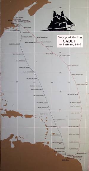
Painting on board
72 x 48 in.
Collection of Erik Ronnberg
Chart showing the voyage of the brig Cadet to Surinam and return, March 10–June 11, 1840.
Also filed under: "Cadet" (Brig) » // Surinam Trade »

Hermaphrodite brigs—more commonly called half-brigs by American seamen and merchants—were square-rigged only on the fore mast, the main mast being rigged with a spanker and a gaff-topsail. Staysails were often set between the fore and main masts, there being no gaff-rigged sail on the fore mast. (1)
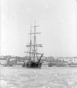
The half-brig was the most common brig type used in the coasting trade and appears often in Lane’s coastal and harbor scenes. The type was further identified by the cargo it carried, if it was conspicuously limited to a specialized trade. Lumber brigs (see Shipping in Down East Waters, 1854 (inv. 212) and View of Southwest Harbor, Maine: Entrance to Somes Sound, 1852 (inv. 260)) and hay brigs (see Lighthouse at Camden, Maine, 1851 (inv. 320)) were recognizable by their conspicuous deck loads. Whaling brigs were easily distinguished by their whaleboats carried on side davits (see ). (2)
– Erik Ronnberg
References:
1. M.H. Parry, et al., Aaak to Zumbra: A Dictionary of the World's Watercraft Newport News, VA: The Mariners’ Museum, 2000), 268, 274; and A Naval Encyclopaedia (L.R. Hamersly & Co., 1884. Reprint: Detroit, MI: Gale Research Company, 1971), 93, under "Brig-schooner."
2. W.H. Bunting, An Eye for the Coast (Gardiner, ME: Tilbury House: 1998), 52–54, 68–69; and W.H. Bunting, A Day's Work, part 1 (Gardiner, ME: Tilbury House: 1997), 52.
The timber trade played an important role in New England’s economy from Colonial days through the mid-19th century, supplying the vast quantities of lumber which a rapidly growing nation demanded. While Cape Ann’s woodlands were depleted early on, timber continued to be harvested from northern New England and the Maritime Provinces right up to the Civil War.
With a deep and safe harbor, Gloucester often served as a layover spot where vessels bound from Maine to Boston, New York or Baltimore and heavily laden with lumber could ride out bad weather. Because of this, Fitz Henry Lane’s paintings of Gloucester Harbor often show a schooner or a brig, loads of lumber clearly visible on their decks, sheltering along the Western Shore.
References:
Honey, Mark E., "King Pine, Queen Spruce, Jack Tar," An Intimate History of Lumbering on the Union River, Volumes 1-5. This source, in its entirety, lays down the foundation of Downeast Maine's unique culture which was built upon pine lumber and timber, the cod fisheries, coasting, shipbuilding, and the interrelationships of family and community.

1852 Photograph
Also filed under: Schooner (Coasting / Lumber / Topsail / Packet / Marsh Hay) »
Advertisement for The Bangor News Company, est. January 31, 1881 Castine Historical Society Collections (2008.02)
Also filed under: Historic Photographs »
"The Maine Register for the Year 1855, embracing State and County Officers, and an abstract of the law and resolves; together with a complete business directory of the state, and a variety of useful information."
Details about Maine's lumber trade in 1855, see pp. 250–52
Also filed under: Castine » // Schooner (Coasting / Lumber / Topsail / Packet / Marsh Hay) »