An online project under the direction of the CAPE ANN MUSEUM
Catalogue Entry
- Ten Pound Island
- George H. Rogers's wharf
- Merchant bark
- Schooner (coastal trade)
- Schooner (fishing)
- Schooner (fishing)
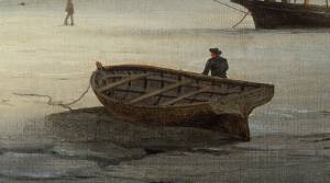
- Yawl boat
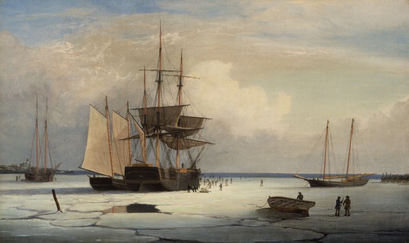
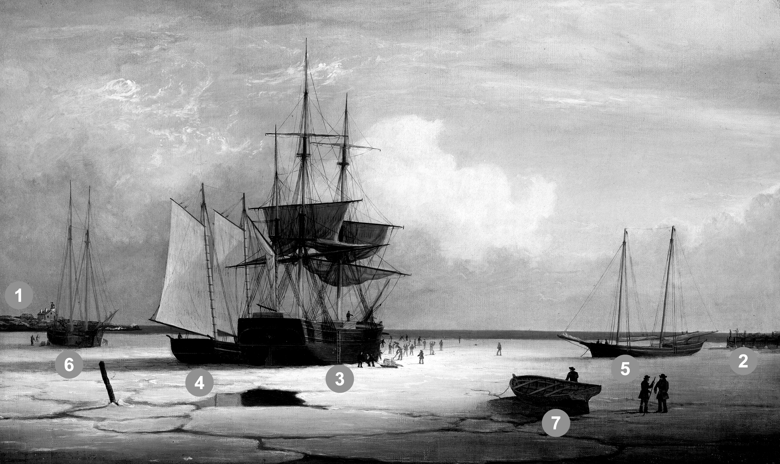
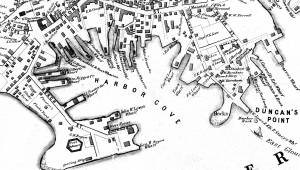
This painting might be more accurately titled “Ships in Ice off Fort Point,” as the vessels are much closer to that location, even if all we see is a corner of George H. Rogers’s wharf projecting from it.
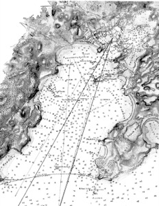
Winters on Cape Ann are seldom so severe that a significant part of Gloucester Harbor will freeze over. Two such events were indicated on the original U.S. Coast Survey chart of Gloucester Harbor, which was completed in 1853 and updated to 1875. The first freeze was in the winter of 1855–56 and was confined to the Inner Harbor east of a line from Duncan’s Point to Rocky Neck. The second took place the following winter, covering the entire harbor out to a line extending from Norman’s Woe to Eastern Point.
In Lane’s painting, the line of ice extends from Fort Point to Rocky Neck’s western shoreline, but not as far as Ten Pound Island. The extent of the ice eliminates the possibility that this was the 1855–56 freeze. Here is a view of the ice still advancing to the Outer Harbor entrance—or receding, having already reached its furthest extent.
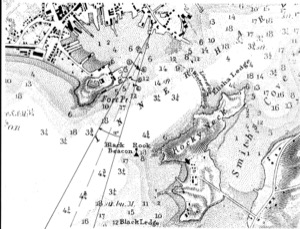
Finding the direction and scope (or angle) of this view meant plotting two lines: one intersecting Ten Pound Island; the other, a small corner of George H. Rogers’s wharf. Placing the background in the middle of the harbor entrance—so there could be no land on the painting’s horizon—led to a viewing point on Fears’ Wharf off Duncan’s Point. Moving that point anywhere else would cause the resulting twelve-degree angle of view to narrow even more, or bring Norman’s Woe into the right background. Interestingly, Lane’s house is very close to this angle’s median line if it is extended inland, but the house is too high for this view. It must have been drawn no more than 10-12 feet above sea level, suggesting that Lane was drawing while sitting on the wharf at high tide.
Another possibility is that Lane made his pencil sketch of this view in warm weather, then painted a winter version in the comfort of his studio. It is also possible that he used just a small section of a sketch with a much wider view. He had only to look out the window for colors, light, and cloud formations, then add vessels and human activity where he judged was most suitable. The result was a convincing winter scene, “painted from nature,” set in midafternoon with the midafternoon sun’s rays brightening wintry storm clouds off to the east.
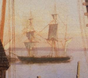
In left center is a merchant bark breaking through the ice to leave port. What appears to be boxes of provisions for the crew are being delivered by sled. Ahead of the bark is a team of men with picks and hammers, chopping and pounding the ice to form cracks and small pieces that the bark can dislodge and ride over. Astern in her shadow are loose blocks of ice that were pushed under and aside as the bark made headway. Secured to the bark’s side is a small schooner—probably used in the coasting trade—assisting in the ice-breaking process. With her sails set, she is forced by the wind to heel, bearing down on the ice and causing it to crack and break up, easing the bark’s task of breaking through.
The two other schooners (far left and far right) are probably fishing vessels, their finely modeled hulls showing the growing presence and influence of the “sharpshooter” and “clipper” schooners. Improved rail transportation to the midwest was beginning to generate greater demand for fish—fresh fish in particular. This meant the need for faster vessels to get fresh fish quickly from the fishing grounds to market, sparking a revival in Gloucester’s fishing industry just as its foreign trade was in decline. The juxtaposition of a merchant bark of antiquated design among two trendsetting examples of fishing schooners in antebellum Gloucester is probably an unintended mix of promise and foreboding on Lane’s part, but there it is.
– Erik Ronnberg
Historical Materials
Newsprint
From bound volume owned by publisher Francis Procter
Collection of Fred and Stephanie Buck
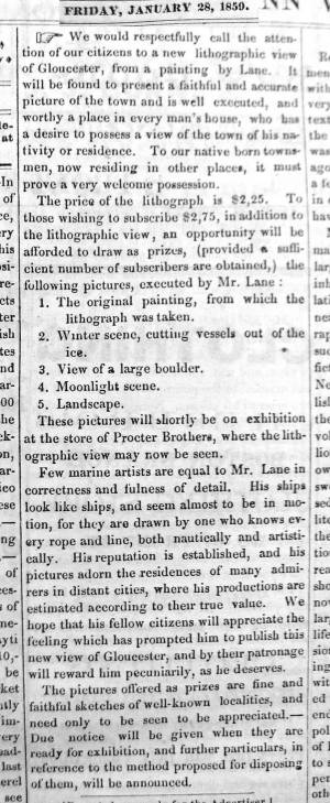
"We would respectfully call the attention of our citizens to a new lithographic view of Gloucester, from a painting by Lane. It will be found to present a faithful and accurate picture of the town and is well executed, and worthy a place in every man's house, who has a desire to possess a view of the town of his nativity or residence. To our native born townsmen, now residing in other places, it must prove a very welcome possession. The price of the lithograph is $2.25. To those wishing to subscribe $2.75, in addition to the lithographic view, an opportunity will be afforded to draw as prizes, (provided a sufficient number of subscribers are obtained,) the following pictures, executed by Mr. Lane:
1. The original painting, from which the lithograph was taken.
2. Winter scene, cutting vessels out of the ice.
3. View of a large boulder.
4. Moonlight scene.
5. Landscape.
These pictures will shortly be on exhibition at the store of Procter Brothers, where the lithographic view may now be seen.
Few marine artists are equal to Mr. Lane in correctness and fulness of detail. His ships look like ships, and seem almost to be in motion, for they are drawn by one who knows every rope and line, both nautically and artistically. His reputation and established, and his pictures adorn the residences of many admirers in distant cities, where his productions are estimated according to there true value. We hope that his fellow citizens will appreciate the feeling which has prompted him to publish this new view of Gloucester, and by their patronage will reward him pecuniarily, as he deserves.
The pictures offered as prizes are fine and faithful sketches of well-known localities, and need only to be seen to be appreciated. – Due notice will be given when they are ready for exhibition, and further particulars, in reference to the method proposed for disposing of them, will be announced."
Newspaper
"Home Pictures- Our citizens should be thankful to our fellow townsman, F.H. Lane, Esq., who has reproduced the scene of winter of '56-7 on canvas, so life-like that one can almost imagine himself in the ice again. The picture is to join the new views of Gloucester as a prize."
Filed under: Newspaper / Journal Articles »
9.21.1859 Newspaper Gloucester Telegraph, p. 2, col. 3 Boston Public Library Accession # G587
"DRAWING OF PAINTINGS.– The distribution of five oil paintings among the subscribers to Lane’s view of Gloucester, took place on Saturday Evening, at the store of Messrs. Procter Brothers. No. 125 took the first picture, being the original painting from which the view of Gloucester was engraved. It is a valuable picture, and Mr. John H. Whidden was the lucky holder of the number. The second picture, a winter scene, giving a representation of cutting vessels out of the ice, fell to No. 186, the holder of which was Mr. William Parsons, 2d. The third picture, a moonlight scene, was taken by No. 263, which was held by Mr. Joseph Richardson of Boston. The fourth, a landscape view, fell to No. 2, the owner of which was Mr. Solomon Pool. No. 93 took the fifth, a view of a large boulder, and Mr. William D. Winchester held the ticket."
Newspaper
"New lithographic view of Gloucester from a painting by Lane View of the Town, price 2.25. For 2.75 your name can be added to a draw. The prizes are "the following pictures executed by Mr. Lane:
1) the original painting, from which the lithograph was taken
2) Winter Scene, cutting vessels out of the ice.
3) View of a large boulder
4) Moonlight Scene
5) Landscape"
Oil on canvas
12 1/8 x 19 3/4 in.
Museum of Fine Arts, Boston, Bequest of Martha C. Karolik for the M.and M. Karolik Collection of American Paintings, 1815-1865 (48.447)
A schooner's yawl lies marooned in the ice-bound harbor in this detail.
Filed under: Yawl Boat »
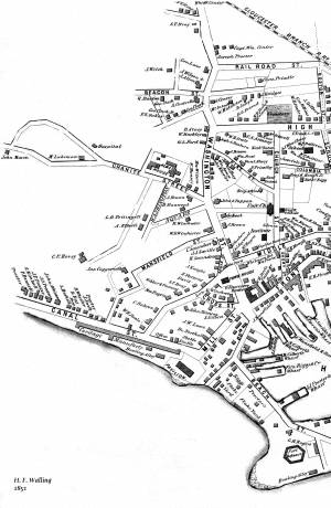
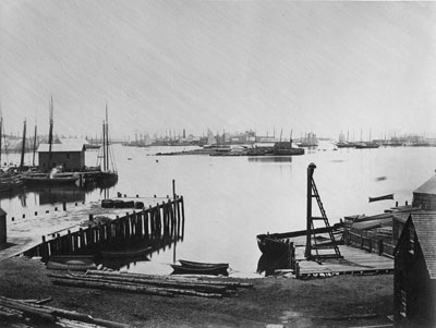
George H. Rogers was one of Gloucester's most enterprising citizens of the mid-nineteenth century. In the early 1830s, he ventured into the Surinam trade with great success, leading him to acquire a wharf at the foot of Sea Street. Due to Harbor Cove's shallow bottom at low tide, berthings at wharves had to be done at high tide, leaving the ships grounded at other times. Many deep-loaded vessels had to anchor outside Harbor cove and be partially off-loaded by "lighters" (shallow-draft vessels that could transfer cargo to the wharves) before final unloading at wharfside. To lessen this problem, Rogers had an unattached extension built out from his wharf into deeper water (see The Fort and Ten Pound Island, Gloucester (Harbor Scene), 1848 (inv. 58), right middle ground). The space between the old wharf and the extension may have been a way to evade harbor regulations limiting how far a pier head could extend into the harbor. Stricter rules were not long in coming after this happened!
About 1848, Rogers acquired land on the east end of Fort Point, first putting up a large three-story building adjacent to Fort Defiance, then a very large wharf jutting out into Harbor Cove. Lane's depictions of Harbor Cove and Fort Point show progress of this construction in 1848 (The Fort and Ten Pound Island, Gloucester (Harbor Scene), 1848 (inv. 58)), 1850 (Gloucester Inner Harbor, 1850 (inv. 240)), and c.1851 (Gloucester Harbor at Dusk, c.1852 (inv. 563)). A corner of the new wharf under construction can also be seen more closely in Ten Pound Island, Gloucester, 1850s (inv. 17) and Ten Pound Island in Gloucester Harbor, 1864 (inv. 104) (foregrounds). This new wharf provided better frontage for large ships to load and unload, as well as larger warehouses and lofts for storage of goods and vessel gear.
By 1860, Rogers was unloading his Surinam cargos at Boston, as ever-larger ships and barks were more easily berthed there. His Gloucester wharves continued to be used for deliveries of trade goods by smaller vessels. In the late 1860s, Rogers' wharf at Fort Point (called "Fort Wharf" in Gloucester directories) was acquired by (Charles D.) Pettingill & (Nehemiah) Cunningham for use in "the fisheries" as listed by the directory. in 1876, it was sold to (John J.) Stanwood & Company, also for use in "the fisheries." (1)
Lowe's Wharf, adjacent to Fort Wharf, was acquired by (Sylvester) Cunningham & (William) Thompson, c.1877 and used in "the fisheries" as well. That wharf and its buildings were enlarged considerably as the business grew. By this time, Harbor Cove was completely occupied by businesses in the fisheries or providing services and equipment to the fishing fleet. In photographs of Fort Point from this period, it is difficult to distinguish one business from another, so closely are they adjoined.
– Erik Ronnberg
Reference:
1. A city atlas, dated 1899, indicates that Rogers's wharf at Fort Point was still listed as part of his estate. If so, then Stanwood & Co. would have been leasing that facility from the Rogers's estate.
44 x 34 in.
Henry Francis Walling, Map of the Towns of Gloucester and Rockport, Essex Co. Massachusetts. Philadelphia, A. Kollner, 1851
Cape Ann Museum Library & Archive
"Map of the Towns of Gloucester and Rockport, Massachusetts. H.F. Walling, Civil Engineer. John Hanson, Publisher. 1851. Population of Gloucester in 1850 7,805. Population of Rockport in 1850 3,213."
Segment of Harbor Village portion of map showing Low's, Rogers', and other wharves in the Inner Harbor.
Also filed under: Low (Frederick G.) wharves »
44 x 34 in.
Henry Francis Walling, Map of the Towns of Gloucester and Rockport, Essex Co. Massachusetts. Philadelphia, A. Kollner, 1851
Cape Ann Museum Library & Archive
"Map of the Towns of Gloucester and Rockport, Massachusetts. H.F. Walling, Civil Engineer. John Hanson, Publisher. 1851. Population of Gloucester in 1850 7,805. Population of Rockport in 1850 3,213."

44 x 34 in.
John Hanson, Publisher
Cape Ann Museum Library & Archive
"Map of the Towns of Gloucester and Rockport, Massachusetts. H.F. Walling, Civil Engineer. John Hanson, Publisher. 1851. Population of Gloucester in 1850 7,805. Population of Rockport in 1850 3,213."
Also filed under: Fort (The) and Fort Point » // Low (Frederick G.) wharves » // Maps » // Town / Public Landings » // Waterfront, Gloucester » // Windmill »

1865 41 x 29 inches Courtesy of the Massachusetts Archives Maps and Plans, Third Series Maps, v.66:p.1, no. 2352, SC1/series 50X
.
Also filed under: Burnham Brothers Marine Railway » // Collins's, William (estate wharf) » // Gloucester Harbor, Inner / Harbor Cove » // Maps »

1876 Photograph Cape Ann Museum Library & Archive
Ignatius Weber's windmill (now defunct) is shown.
Also filed under: Flake Yard » // Fort (The) and Fort Point » // Gloucester Harbor, Inner / Harbor Cove » // Historic Photographs » // Schooner (Fishing) » // Waterfront, Gloucester » // Windmill »
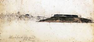
Through the years, this point and its fortifications had many names: Watch House Point, the Old Battery, Fort Defiance, Fort Head, and now just "The Fort." In 1793, Fort Defiance was turned over to the young United States government and was allowed to deteriorate. During the War of 1812 it was described as being "in ruins," and any remaining buildings burned in 1833. It was resuscitated in the Civil War and two batteries of guns were installed. The City of Gloucester did not regain ownership of the land until 1925.
The first fortifications on this point, guarding the entrance to the Inner Harbor, were put up in the 1740s, when fear of attack from the French led to the construction of a battery armed with twelve-pounder guns. Greater breastworks were thrown up in 1775, after Capt. Lindsay and his sloop-of-war the "Falcon" attacked the unprepared town. They were small and housed only a few cannon and local soldiers. Several other fortifications were at various times erected around the harbor: Fort Conant at what is now Stage Fort Park, another on Duncan's Point (near site of Lane's house) and the Civil War fort on Eastern Point. None of these preparations was ever called upon to actually defend the town.
Lane during his lifetime created a long series of images of the point and the condition of its fortifications. In 1832 there were still buildings standing, and the point had not yet been used for major wharves and warehouses. By the time of his painting Gloucester Harbor, 1852 (inv. 38), one can see that the earthwork foundation, but no superstructures, survived.
– Sarah Dunlap


1860 In John J. Babson, History of the Town Gloucester (Gloucester, MA: Procter Brothers, 1860) Cape Ann Museum Library & Archives, Gloucester, Mass.
See p. 474.
View related catalogue entries (4) »
Also filed under: Babson History of the Town of Gloucester » // Chebacco Boat / Dogbody / Pinky » // Gloucester Harbor, Inner / Harbor Cove » // Gloucester, Mass. - "Ten Pound Island Light » // Schooner (Coasting / Lumber / Topsail / Packet / Marsh Hay) » // Ten Pound Island »
Newsprint
Gloucester Telegraph
About picture of Old Fort hanging in the Gloucester Bank: "This picture is chiefly of interest on account of its preserving so accurately the features of a view so familiar to many of our citizens and which can never exist in reality."
Also filed under: Chronology » // Gloucester Bank » // Gloucester, Mass. – Gloucester Bank » // Newspaper / Journal Articles »

24 x 38 in.
Gloucester City Archives
"Drawn on a scale of one hundred feet to an inch. By John Mason 1834–45 from Actual Survey showing every Lott and building then standing on them giving the actual size of the buildings and width of the streets from the Canal to the head of the Harbour & part of Eastern point as farr as Smith's Cove and the Shore of the same with all the wharfs then in use. Gloucester Harbor 1834–35."
This map is especially useful in showing the Fort.
Also filed under: Flake Yard » // Maps » // Mason, John » // Pavilion (Publick) Beach » // Town / Public Landings »
44 x 34 in.
John Hanson, Publisher
Cape Ann Museum Library & Archive
"Map of the Towns of Gloucester and Rockport, Massachusetts. H.F. Walling, Civil Engineer. John Hanson, Publisher. 1851. Population of Gloucester in 1850 7,805. Population of Rockport in 1850 3,213."
Also filed under: Low (Frederick G.) wharves » // Maps » // Rogers's (George H.) wharves » // Town / Public Landings » // Waterfront, Gloucester » // Windmill »
Newsprint
Cape Ann Advertiser
Cape Ann Museum Library & Archive
"Fort Hill was occupied by Capt. H. C. Mackay and John Lowe, as a flake-yard, and there were but one or two old fish-houses in the vicinity. The improvements at this point during the last fifteen years have left no traces of its former appearance, almost every landmark having been obliterated. A very good idea of the place as it then appeared may be obtained from the painting of Fitz H. Lane, Esq., now on exhibition at the Reading Room under the Gloucester Bank."
Also filed under: Gloucester Bank » // Newspaper / Journal Articles »
Newspaper
Gloucester Telegraph
"By the will of the late Fitz H. Lane, Esq., his handsome painting of the Old Fort, Ten Pound Island, etc., now on exhibition at the rooms of the Gloucester Maritime Insurance Co., was given to the town... It will occupy its present position until the town has a suitable place to receive it."
Also filed under: Funeral & Burial » // Gloucester, Mass. – Marine Insurance Company » // Newspaper / Journal Articles » // Ten Pound Island »
Newsprint
Gloucester Telegraph
At the dedication of the Town House, speaker, "read the following letter:
To the Selectmen of Gloucester: / Gents: The will of our late Townsman, Fitz. H. Lane, contains this provision: / I give to the inhabitants of the Town of Gloucester, the picture of the Old Fort, to be kept as a memento[sic] of one of the localities of olden time; the said picture now hanging in the Reading Room under the Gloucester Bank, and to be there kept until the Town of Gloucester shall furnish a suitable and safe place to hang it. / The original sketch was taken twenty-five years ago, but the boats and vessels introduced are those of a quarter of a century earlier still. The painting was executed in 1859, six years before his decease."
Also filed under: Documents / Objects » // Newspaper / Journal Articles » // Town House »

Stereograph card
Cape Ann Museum Library & Archive
View from top of Unitarian Church on Middle Street looking southeast, showing the Fort and Ten Pound Island. Tappan Block and Main Street buildings between Center and Hancock in foreground.
Also filed under: Ten Pound Island » // Unitarian Church / First Parish Church (Middle Street) »
1876 Photograph Cape Ann Museum Library & Archive
Ignatius Weber's windmill (now defunct) is shown.
Also filed under: Flake Yard » // Gloucester Harbor, Inner / Harbor Cove » // Historic Photographs » // Rogers's (George H.) wharves » // Schooner (Fishing) » // Waterfront, Gloucester » // Windmill »
Ten Pound Island guards the entrance to Gloucester’s Inner Harbor and provides a crucial block to heavy seas running southerly down the Outer Harbor from the open ocean beyond. The rocky island and its welcoming lighthouse is seen, passed, and possibly blessed by every mariner entering the safety of Gloucester’s Inner Harbor after outrunning a storm at sea. Ten Pound Island is situated such that the Inner Harbor is protected from open water on all sides making it one of the safest harbors in all New England.
Legend has it that the island was named for the ten pound sum paid to the Indians for the island, and the smaller Five Pound Island deeper in the Inner Harbor was purchased for that lesser sum. None of it makes much financial sense when the entirety of Cape Ann was purchased for only seven pounds from the Indian Samuel English, grandson of Masshanomett the Sagamore of Agawam in 1700. From approximately 1640 on the island was used to hold rams, and anyone putting female sheep on the island was fined. Gloucester historian Joseph Garland has posited that the name actually came from the number of sheep pens it held, or pounds as they were called, and the smaller Five Pound Island was similarly named.
The island itself is only a few acres of rock and struggling vegetation but is central to the marine life of the harbor as it defines the eastern edge of the deep channel used to turn the corner and enter the Inner Harbor. The first lighthouse was lit there in 1821, and a house was built for the keeper adjacent to the lighthouse.
In the summer of 1880 Winslow Homer boarded with the lighthouse keeper and painted some of his most masterful and evocative watercolor views of the busy harbor life swirling about the island at all times of day. Boys rowing dories, schooners tacking in and out in all weather, pleasure craft drifting in becalmed water, seen together they tell a Gloucester story of light, water and sail much as Lane’s work did only several decades earlier.

Colored lithograph
Cape Ann Museum Library and Archive
Also filed under: Gloucester, Mass. - "Ten Pound Island Light »

Photograph
From The Illustrated Coast Pilot with Sailing Directions. The Coast of New England from New York to Eastport, Maine including Bays and Harbors, N. L. Stebbins, 1891.
Also filed under: Gloucester, Mass. - "Ten Pound Island Light »


Oil on canvas
22 x 36 in.
Cape Ann Museum, Gloucester, Mass., deposited by the Collection of Addison Gilbert Hospital, 1978 (DEP. 201)
Detail of party boat.
Also filed under: Party Boat »

Engraving of 1819 survey taken from American Coast Pilot 14th edition
9 1/2 x 8 in.
Cape Ann Museum Library & Archive
D32 FF5
Also filed under: Dolliver's Neck » // Eastern Point » // Maps » // Norman's Woe »
Newspaper
Gloucester Telegraph
"By the will of the late Fitz H. Lane, Esq., his handsome painting of the Old Fort, Ten Pound Island, etc., now on exhibition at the rooms of the Gloucester Maritime Insurance Co., was given to the town... It will occupy its present position until the town has a suitable place to receive it."
Stereograph card
Cape Ann Museum Library & Archive
View from top of Unitarian Church on Middle Street looking southeast, showing the Fort and Ten Pound Island. Tappan Block and Main Street buildings between Center and Hancock in foreground.
Also filed under: Fort (The) and Fort Point » // Unitarian Church / First Parish Church (Middle Street) »
1860 In John J. Babson, History of the Town Gloucester (Gloucester, MA: Procter Brothers, 1860) Cape Ann Museum Library & Archives, Gloucester, Mass.
See p. 474.
View related catalogue entries (4) »
Also filed under: Babson History of the Town of Gloucester » // Chebacco Boat / Dogbody / Pinky » // Fort (The) and Fort Point » // Gloucester Harbor, Inner / Harbor Cove » // Gloucester, Mass. - "Ten Pound Island Light » // Schooner (Coasting / Lumber / Topsail / Packet / Marsh Hay) »
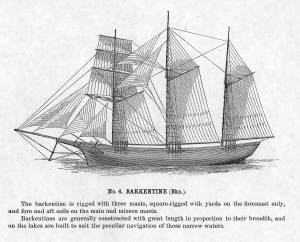
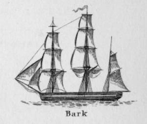
In the ninteenth century, the term "bark" was applied to a large sailing vessel having three masts, the first two (fore and main) being square-rigged; the third (mizzen), fore-and-aft rigged. The reduced square-rig made the vessel easier and more economical to handle, using a smaller crew. (1)
Barks had significant presence in mid-nineteenth-century America, as indicated by Lane’s depictions of them. Hardly any are to be found in his scenes of major ports, but some do appear in his Cape Ann scenes (see The Fort and Ten Pound Island, Gloucester (Harbor Scene), 1848 (inv. 58), View of Gloucester, 1859 (inv. 91), Gloucester Harbor, 1850s (inv. 391), and Bark "Eastern Star" of Boston, 1853 (inv. 571)), also in views of other small ports and of coastal shipping (see Clipper Ship "Southern Cross" in Boston Harbor, 1851 (inv. 253), Merchantmen Off Boston Harbor, 1853 (inv. 267), Approaching Storm, Owl's Head, 1860 (inv. 399), and Bark "Mary", n.d. (inv. 629)).
Brigs, and to a lesser extent ships, were the vessels of choice for Gloucester’s foreign trade in the first half of the nineteenth century. They brought cargos from the West Indies, South America, and Europe, anchoring in the deeper parts of the Inner Harbor while lighters off-loaded the goods and landed them at the wharves in Harbor Cove, by then too shallow for the newer, larger merchant vessels coming into use. (2) By mid-century, barks were gradually replacing brigs and ships, while the trade with Surinam was removed to Boston in 1860. (3)
Some bulk cargos still had to be landed in Gloucester, salt for curing fish being the most important. “Salt barks” brought Tortugas salt from the West Indies, and in the 1870s, Italian salt barks began bringing Trapani salt from Sicily. The importation of salt by sailing ships ended with the outbreak of World War I. (4)
The term barkentine, like the bark, pre-dates the nineteenth century, but in the mid- to late 1800s referred to a large vessel of three masts (or more), with only the fore mast square-rigged, the others being fore-and-aft-rigged. In Lane’s time, the term was little known in the United States, while many other names were coined for the rig. One of these early terms was demi-bark, probably from the French demi-barque, which was applied to a very different kind of vessel. (5) Lane’s depictions of these rigs include a lithograph of the steam demi-bark "Antelope" View of Newburyport, (From Salisbury), 1845 (inv. 499) and at least three depictions of Cunard steamships The "Britannia" Entering Boston Harbor, 1848 (inv. 49), Cunard Steamship Entering Boston Harbor, n.d. (inv. 197), and Cunard Liner "Britannia", 1842 (inv. 259). (6) None of these subjects typify the barkentine rig as applied to sails-only rigs as they developed in the years after Lane’s death.
– Erik Ronnberg (May, 2015)
References:
1. R[ichard] H[enry] Dana, Jr., The Seaman's Friend (Boston; Thomas Groom & Co., 1841. 13th ed., 1873), 97 and Plate IV with captions; and M.H. Parry, et al., Aak to Zumbra: A Dictionary of the World's Watercraft (Newport News, VA: The Mariners’ Museum, 2000), 43.
2. Alfred Mansfield Brooks, Gloucester Recollected (Gloucester, MA: Peter Smith, 1974), 56, note 10; 67, note 7.
3. James R. Pringle, History of the Town and City of Gloucester (1892. Reprint: Gloucester, MA, 1997), 106–08.
4. Raymond McFarland, A History of the New England Fisheries (Philadelphia: University of Pennsylvania, 1911), 95–96; and Mark Kurlansky, Salt: A World History (New York: Walker & Co., 2002), 419–420.
5. Parry, 44, 167. Dana has neither definition nor illustration of this rig.
6. J[ohn] W. Griffiths, “The Japan and China Propeller Antelope," U.S. Nautical Magazine III (October 1855): 11–17. This article includes an impression of Lane’s lithograph on folded tissue.
c.1875 Stereograph card Cape Ann Museum Library & Archive
This view of Gloucester's Inner Harbor shows three square-rigged vessels in the salt trade at anchor. The one at left is a (full-rigged) ship; the other two are barks. By the nature of their cargos, they were known as "salt ships" and "salt barks" respectively. Due to their draft (too deep to unload at wharfside) they were partially unloaded at anchor by "lighters" before being brought to the wharves for final unloading.
– Erik Ronnberg
Also filed under: Historic Photographs » // Salt » // Waterfront, Gloucester »

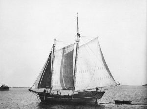
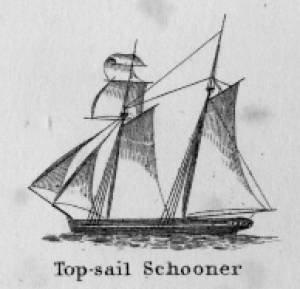
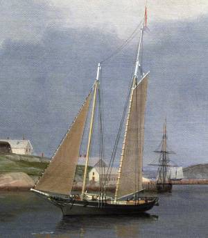
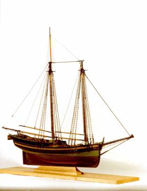
Schooners in Lane’s time were, with few exceptions, two-masted vessels carrying a fore-and-aft rig having one or two jibs, a fore staysail, gaff-rigged fore- and main sails, and often fore- and main topsails. One variant was the topsail schooner, which set a square topsail on the fore topmast. The hulls of both types were basically similar, their rigs having been chosen for sailing close to the wind. This was an advantage in the coastal trade, where entering confined ports required sailing into the wind and frequent tacking. The square topsail proved useful on longer coastwise voyages, the topsail providing a steadier motion in offshore swells, reducing wear and tear on canvas from the slatting of the fore-and-aft sails. (1)
Schooners of the types portrayed by Lane varied in size from 70 to 100 feet on deck. Their weight was never determined, and the term “tonnage” was a figure derived from a formula which assigned an approximation of hull volume for purposes of imposing duties (port taxes) on cargoes and other official levies. (2)
Crews of smaller schooners numbered three or four men. Larger schooners might carry four to six if a lengthy voyage was planned. The relative simplicity of the rig made sail handling much easier than on a square-rigged vessel. Schooner captains often owned shares in their vessels, but most schooners were majority-owned by land-based firms or by individuals who had the time and business connections to manage the tasks of acquiring and distributing the goods to be carried. (3)
Many schooners were informally “classified” by the nature of their work or the cargoes they carried, the terminology coined by their owners, agents, and crews—even sometimes by casual bystanders. In Lane’s lifetime, the following terms were commonly used for the schooner types he portrayed:
Coasting schooners: This is the most general term, applied to any merchant schooner carrying cargo from one coastal port to another along the United States coast (see Bar Island and Mt. Desert Mountains from Somes Settlement, 1850 (inv. 401), right foreground). (4)
Packet schooners: Like packet sloops, these vessels carried passengers and various higher-value goods to and from specific ports on regular schedules. They were generally better-maintained and finished than schooners carrying bulk cargoes (see The Old Fort and Ten Pound Island, Gloucester, 1850s (inv. 30), center; and Gloucester Inner Harbor, 1850 (inv. 240), stern view). (5)
Lumber schooners: Built for the most common specialized trade of Lane’s time, they were fitted with bow ports for loading lumber in their holds (see View of Southwest Harbor, Maine: Entrance to Somes Sound, 1852 (inv. 260)) and carried large deck loads as well (Stage Rocks and the Western Shore of Gloucester Outer Harbor, 1857 (inv. 8), right). Lumber schooners intended for long coastal trips were often rigged with square topsails on their fore masts (see Becalmed Off Halfway Rock, 1860 (inv. 344), left; ; and Lumber Schooner in a Gale, 1863 (inv. 552)). (6)
Schooners in other specialized trades. Some coasting schooners built for carrying varied cargoes would be used for, or converted to, special trades. This was true in the stone trade where stone schooners (like stone sloops) would be adapted for carrying stone from quarries to a coastal destination. A Lane depiction of a stone schooner is yet to be found. Marsh hay was a priority cargo for gundalows operating around salt marshes, and it is likely that some coasting schooners made a specialty of transporting this necessity for horses to urban ports which relied heavily on horses for transportation needs. Lane depicted at least two examples of hay schooners (see Gloucester Harbor, 1850s (inv. 391), left; and Coasting Schooner off Boon Island, c.1850 (inv. 564)), their decks neatly piled high with bales of hay, well secured with rope and tarpaulins.
– Erik Ronnberg
References:
1. Howard I. Chapelle, The History of American Sailing Ships (New York: W.W. Norton & Co., 1935), 258. While three-masted schooners were in use in Lane’s time, none have appeared in his surviving work; and Charles S. Morgan, “New England Coasting Schooners”, The American Neptune 23, no. 1 (DATE): 5–9, from an article which deals mostly with later and larger schooner types.
2. John Lyman, “Register Tonnage and its Measurement”, The American Neptune V, nos. 3–4 (DATE). American tonnage laws in force in Lane’s lifetime are discussed in no. 3, pp. 226–27 and no. 4, p. 322.
3. Ship Registers of the District of Gloucester, Massachusetts, 1789–1875 (Salem, MA: The Essex Institute, 1944). Vessels whose shipping or fishing voyages included visits to foreign ports were required to register with the Federal Customs agent at their home port. While the vessel’s trade or work was unrecorded, their owners and master were listed, in addition to registry dimensions and place where built. Records kept by the National Archives can be consulted for information on specific voyages and ports visited.
4. Howard I. Chapelle, The National Watercraft Collection (Washington, DC: Smithsonian Institution, 1960), 40, 42–43.
5. Ibid., 42–43, 73.
6. Ibid., 74–76.

In R. H. Dana, The Seaman's Friend, 13th ed. (Thomas Groom & Co. Publisher, 1873)
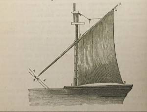
A topsail schooner has no tops at her foremast, and is fore-and-aft rigged at her mainmast. She differs from an hermaphrodite brig in that she is not properly square-rigged at her foremast, having no top, and carrying a fore-and-aft foresail instead of a square foresail and a spencer.

Detail views: marine railway and hauling cradle for vessel Wood rails, metal rollers, chain; wood cradle. Scale: ½" = 1' (1:24) Original diorama components made, 1892; replacements made, 1993. Cape Ann Museum, from Gloucester Chamber of Commerce, 1925 (2014.071)
A schooner is shown hauled out on a cradle which travels over racks of rollers on a wood and metal track.
Also filed under: Burnham Brothers Marine Railway » // Marine Railways »

c. 1900 Glass plate negative Collection of Erik Ronnberg
Also filed under: Lobstering »
"The Maine Register for the Year 1855, embracing State and County Officers, and an abstract of the law and resolves; together with a complete business directory of the state, and a variety of useful information."
Details about Maine's lumber trade in 1855, see pp. 250–52
Also filed under: Castine » // Lumber Industry »
Schooners in Lane’s time were, with few exceptions, two-masted vessels carrying a fore-and-aft rig having one or two jibs, a fore staysail, gaff-rigged fore- and main sails, and often fore- and main topsails. One variant was the topsail schooner, which set a square topsail on the fore topmast. The hulls of both types were basically similar, their rigs having been chosen for sailing close to the wind. This was an advantage in the coastal trade, where entering confined ports required sailing into the wind and frequent tacking. The square topsail proved useful on longer coastwise voyages, the topsail providing a steadier motion in offshore swells, reducing wear and tear on canvas from the slatting of the fore-and-aft sails. (1)
Schooners of the types portrayed by Lane varied in size from 70 to 100 feet on deck. Their weight was never determined, and the term “tonnage” was a figure derived from a formula which assigned an approximation of hull volume for purposes of imposing duties (port taxes) oncargoes and other official levies. (2)
Crews of smaller schooners numbered three or four men. Larger schooners might carry four to six if a lengthy voyage was planned. The relative simplicity of the rig made sail handling much easier than on a square-rigged vessel. Schooner captains often owned shares in their vessels, but most schooners were majority-owned by land-based firms or by individuals who had the time and business connections to manage the tasks of acquiring and distributing the goods to be carried. (3)
Many schooners were informally “classified” by the nature of their work or the cargoes they carried, the terminology coined by their owners, agents, and crews—even sometimes by casual bystanders. In Lane’s lifetime, the following terms were commonly used for the schooner types he portrayed:
Fishing Schooners: While the port of Gloucester is synonymous with fishing and the schooner rig, Lane depicted only a few examples of fishing schooners in a Gloucester setting. Lane’s early years coincided with the preeminence of Gloucester’s foreign trade, which dominated the harbor while fishing was carried on from other Cape Ann communities under far less prosperous conditions than later. Only by the early 1850s was there a re-ascendency of the fishing industry in Gloucester Harbor, documented in a few of Lane’s paintings and lithographs. Depictions of fishing schooners at sea and at work are likewise few. Only A Smart Blow, c.1856 (inv. 9), showing cod fishing on Georges Bank (4), and At the Fishing Grounds, 1851 (inv. 276), showing mackerel jigging on Georges Bank, are known examples. (5)
– Erik Ronnberg
References:
1. Howard I. Chapelle, The History of American Sailing Ships (New York: W.W. Norton & Co., 1935), 258. While three-masted schooners were in use in Lane’s time, none have appeared in his surviving work; and Charles S. Morgan, “New England Coasting Schooners”, The American Neptune 23, no. 1 (DATE): 5–9, from an article which deals mostly with later and larger schooner types.
2. John Lyman, “Register Tonnage and its Measurement”, The American Neptune V, nos. 3–4 (DATE). American tonnage laws in force in Lane’s lifetime are discussed in no. 3, pp. 226–27 and no. 4, p. 322.
3. Ship Registers of the District of Gloucester, Massachusetts, 1789–1875 (Salem, MA: The Essex Institute, 1944). Vessels whose shipping or fishing voyages included visits to foreign ports were required to register with the Federal Customs agent at their home port. While the vessel’s trade or work was unrecorded, their owners and master were listed, in addition to registry dimensions and place where built. Records kept by the National Archives can be consulted for information on specific voyages and ports visited.
4. Howard I. Chapelle, The National Watercraft Collection (Washington, DC: Smithsonian Institution, 1960), 74–76.
5. Howard I. Chapelle, The American Fishing Schooners (New York: W.W. Norton & Co., 1973), 58–75, 76–101.
1852
Oil on canvas
28 x 48 1/2 in.
Cape Ann Museum, Gloucester, Mass., Deposited by the City of Gloucester, 1952. Given to the city by Mrs. Julian James in memory of her grandfather Sidney Mason, 1913 (DEP. 200)
Detail of fishing schooner.
Also filed under: Gloucester Harbor, Inner / Harbor Cove »
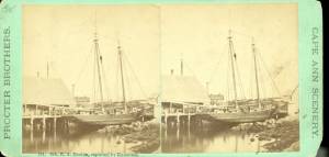
c.1865 Stereograph card Frank Rowell, Publisher stereo image, "x " on card, "x" Cape Ann Museum Library & Archive
View showing a sharpshooter fishing schooner, circa 1850. Note the stern davits for a yawl boat, which is being towed astern in this view.
Also filed under: Historic Photographs »
Model made for marine artist Thomas M. Hoyne
scale: 3/8" = 1'
Thomas M. Hoyne Collection, Mystic Seaport, Conn.
While this model was built to represent a typical Marblehead fishing schooner of the early nineteenth century, it has the basic characteristics of other banks fishing schooners of that region and period: a sharper bow below the waterline and a generally more sea-kindly hull form, a high quarter deck, and a yawl-boat on stern davits.
The simple schooner rig could be fitted with a fore topmast and square topsail for making winter trading voyages to the West Indies. The yawl boat was often put ashore and a "moses boat" shipped on the stern davits for bringing barrels of rum and molasses from a beach to the schooner.
– Erik Ronnberg
References:
Jeffrey Bolster, Black Jacks: African American Seafarers in the Age of Sail (Cambridge, MA: Harvard University Press, 1997).
Howard I. Chapelle, American Small Sailing Craft (New York: W.W. Norton & Co., 1951), 29–31.
Also filed under: Hand-lining » // Ship Models »

20 x 14 in.
Cape Ann Museum Library & Archive, Gloucester, Mass.
The image, as originally drafted, showed only spars and sail outlines with dimensions, and an approximate deck line. The hull is a complete overdrawing, in fine pencil lines with varied shading, all agreeing closely with Lane's drawing style and depiction of water. Fishing schooners very similar to this one can be seen in his painting /entry:240/.
– Erik Ronnberg
Newspaper
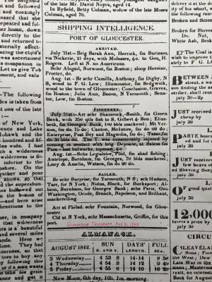
"Shipping Intelligence: Port of Gloucester"
"Fishermen . . . The T. [Tasso] was considerably injured by coming in contact with brig Deposite, at Salem . . ."
Also filed under: Newspaper / Journal Articles »
Newsprint
From bound volume owned by publisher Francis Procter
Collection of Fred and Stephanie Buck
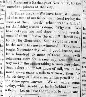
"A Prize Race—We have heard it intimated that some of our fishermen intend trying the merits of their "crack" schooners this fall, after the fishing season is done. Why not! . . .Such a fleet under full press of sail, would be worth going many a mile to witness; then for the witchery of Lane's matchless pencil to fix the scene upon canvass. . ."
Also filed under: Fishing » // Newspaper / Journal Articles »
Also filed under: Cape Ann Advertiser Masthead »

c.1870 Stereograph card Procter Brothers, Publisher Cape Ann Museum Library & Archive
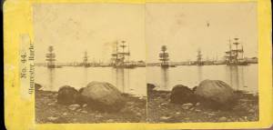
"Gloucester Harbor from Rocky Neck, Looking Southwest. This gives a portion of the Harbor lying between Ten Pound Island and Eastern Point. At the time of taking this picture the wind was from the northeast, and a large fleet of fishing and other vessels were in the harbor. In the range of the picture about one hundred vessels were at anchor. In the small Cove in the foreground quite a number of dories are moored. Eastern Point appears on the left in the background."
Southeast Harbor was known for being a safe harbor.
Also filed under: Gloucester Harbor, Outer » // Historic Photographs » // Rocky Neck » // Small Craft – Wherries, and Dories »
1870s Stereograph card Cape Ann Museum Library & Archive
"Said schooner was captured about the first of September, 1871, by Capt. Torry, of the Dominion Cutter 'Sweepstakes,' for alleged violation of the Fishery Treaty. She was gallantly recaptured from the harbor of Guysboro, N.S., by Capt. Harvey Knowlton., Jr., (one of her owners,) assisted by six brave seamen, on Sunday night, Oct. 8th. The Dominion Government never asked for her return, and the United States Government very readily granted her a new set of papers."
Also filed under: Fishing » // Historic Photographs » // Waterfront, Gloucester »
1876 Photograph Cape Ann Museum Library & Archive
Also filed under: Gloucester Harbor, Inner / Harbor Cove » // Historic Photographs » // Waterfront, Gloucester »

c.1870 Cape Ann Museum Library & Archive (2013.068)
Schooner fleet anchored in the inner harbor. Looking east from Rocky Neck, Duncan's Point wharves and Lane house (at far left), Sawyer School cupola on Friend Street.
Also filed under: Duncan's Point » // Gloucester Harbor, Inner / Harbor Cove » // Historic Photographs » // Waterfront, Gloucester »
See p. 254.
As Erik Ronnberg has noted, Lane's engraving follows closely the French publication, Jal's "Glossaire Nautique" of 1848.
Also filed under: Babson History of the Town of Gloucester »
Wood, cordage, acrylic paste, metal
~40 in. x 30 in.
Erik Ronnberg
Model shows mast of fishing vessel being unstepped.
Also filed under: Burnham Brothers Marine Railway » // Fishing »

Watercolor on paper
8 3/4 x 19 3/4 in.
Cape Ann Museum, Gloucester, Mass., Gift of Rev. and Mrs. A. A. Madsen, 1950
Accession # 1468
Fishing schooners in Gloucester's outer harbor, probably riding out bad weather.
Also filed under: Elwell, D. Jerome » // Gloucester Harbor, Outer »
1876 Photograph Cape Ann Museum Library & Archive
Ignatius Weber's windmill (now defunct) is shown.
Also filed under: Flake Yard » // Fort (The) and Fort Point » // Gloucester Harbor, Inner / Harbor Cove » // Historic Photographs » // Rogers's (George H.) wharves » // Waterfront, Gloucester » // Windmill »
Print from bound volume of Gloucester scenes sent to the Philadelphia Centennial Exhibition.
11 x 14 in.
Cape Ann Museum Library & Archives
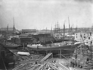
Schooner "Grace L. Fears" at David A. Story Yard in Vincent's Cove.
Also filed under: Historic Photographs » // Shipbuilding / Repair » // Vincent's Cove »
The yawl boat was a ninteenth-century development of earlier ships' boats built for naval and merchant use. Usually twenty feet long or less, they had round bottoms and square sterns; many had raking stem profiles. Yawl boats built for fishing tended to have greater beam than those built for vessels in the coastal trades. In the hand-line fisheries, where the crew fished from the schooner's rails, a single yawl boat was hung from the stern davits as a life boat or for use in port. Their possible use as lifeboats required greater breadth to provide room for the whole crew. In port, they carried crew, provisions, and gear between schooner and shore. (1)
Lane's most dramatic depictions of fishing schooners' yawl-boats are found in his paintings Gloucester Outer Harbor, from the Cut, 1850s (inv. 109) and /entry:311. Their hull forms follow closely that of Chapelle's lines drawing. (2) Similar examples appear in the foregrounds of Gloucester Harbor, 1852 (inv. 38), Ships in Ice off Ten Pound Island, Gloucester, 1850s (inv. 44), and The Fort and Ten Pound Island, Gloucester, Massachusetts, 1847 (inv. 271). A slightly smaller example is having its bottom seams payed with pitch in the foreground of Gloucester Harbor, 1847 (inv. 23). In Gloucester Inner Harbor, 1850 (inv. 240), a grounded yawl boat gives an excellent view of its seating arrangement, while fishing schooners in the left background have yawl boats hung from their stern davits, or floating astern.
One remarkable drawing, Untitled, n.d. (inv. 219) illustrates both the hull geometry of a yawl boat and Lane's uncanny accuracy in depicting hull form in perspective. No hull construction other than plank seams is shown, leaving pure hull form to be explored, leading in turn to unanswered questions concerning Lane's training to achieve such understanding of naval architecture.
– Erik Ronnberg
References:
1. Howard I. Chapelle, American Small Sailing Craft (New York: W.W. Norton & Co., 1951), 222–23.
2. Ibid., 223.
Oil on canvas
12 1/8 x 19 3/4 in.
Museum of Fine Arts, Boston, Bequest of Martha C. Karolik for the M.and M. Karolik Collection of American Paintings, 1815-1865 (48.447)
A schooner's yawl lies marooned in the ice-bound harbor in this detail.

The Ten Pound Island light was built on a three-and-a-half acre island at the eastern end of Gloucester Harbor. Built as a conical stone tower, the original 20-foot-tall Ten Pound Island Light was first lit in October, 1821 after the Commonwealth of Massachusetts and the Town of Gloucester ceded 1.7 acres to the U.S. Government for the construction of an inner harbor lighthouse to help mariners navigate the harbor. Ten Pound Island light was a popular subject with artists, including Winslow Homer, who boarded with the lighthouse keeper at Ten Pound Island in the summer of 1880. It is frequently featured in Lane's paintings of Gloucester Harbor.
This information has been shared with the Lane project by Jeremy D'Entremont. More information can be found at his website, www.newenglandlighthouses.net or in The Lighthouse Handbook New England. This information has also been summarized from Paul St. Germain's book, Lighthouses and Lifesaving Stations on Cape Ann.


Colored lithograph
Cape Ann Museum Library and Archive
Also filed under: Ten Pound Island »
Photograph
From The Illustrated Coast Pilot with Sailing Directions. The Coast of New England from New York to Eastport, Maine including Bays and Harbors, N. L. Stebbins, 1891.
Also filed under: Ten Pound Island »
