An online project under the direction of the CAPE ANN MUSEUM
Catalog entry
inv. 56
View of Gloucester Harbor
View of Gloucester
1852 Oil on canvas 20 1/2 x 30 1/2 in. (52.1 x 77.5 cm) Signed and dated lower right: F.H. Lane 1852
|
Explore catalog entries by keywords view all keywords »
Historical Materials
Below is historical information related to the Lane work above. To see complete information on a subject on the Historical Materials page, click on the subject name (in bold and underlined).
Oil on canvas
36 x 40 inches
Columbia Museum of Art, Columbia, SC
Filed under: Allston, Washington »
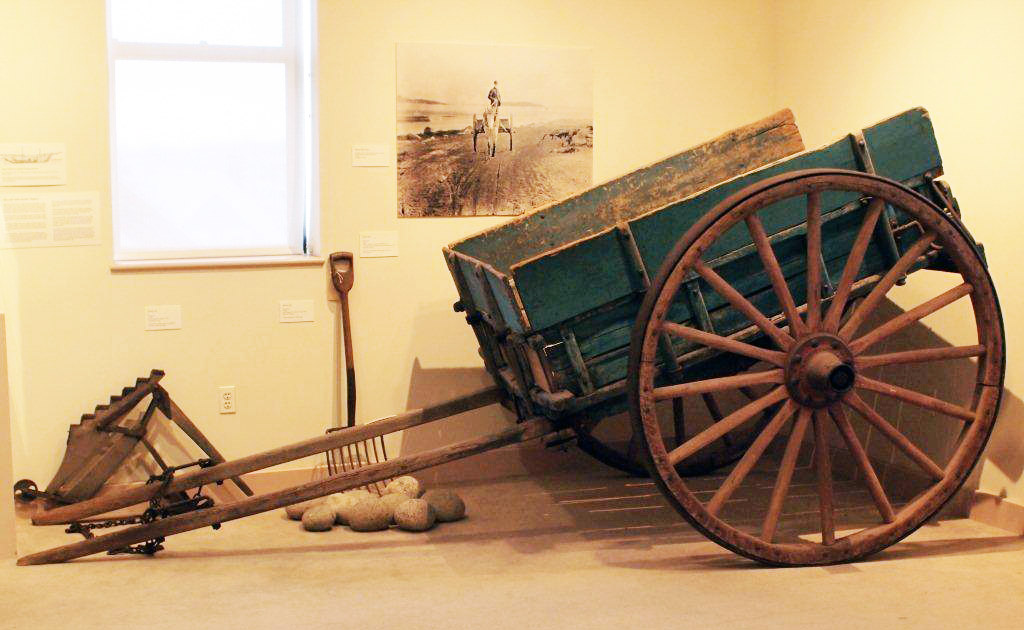
12' 5"l. x 7' I" w. x 4' 9" h.
19th and early 20th c.
Cape Ann Museum. Gift of Thomas A. Robinson, 1983 (2344)
While heavily constructed to transport ballast stone from local beaches, this style of cart was used for many purposes. It is otherwise identical in design to horse-drawn carts depicted in Lane’s paintings.
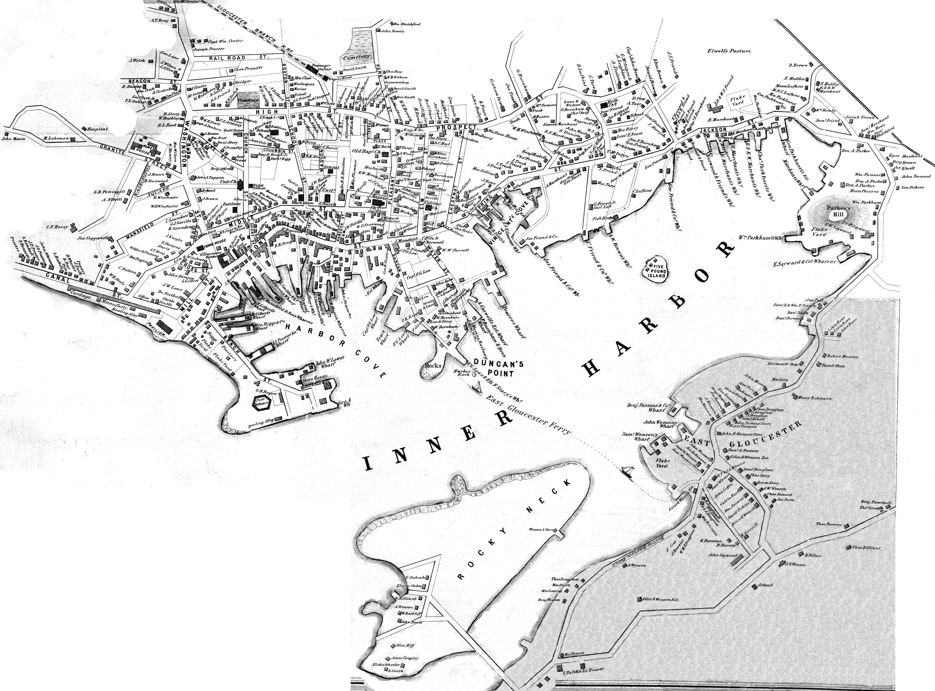
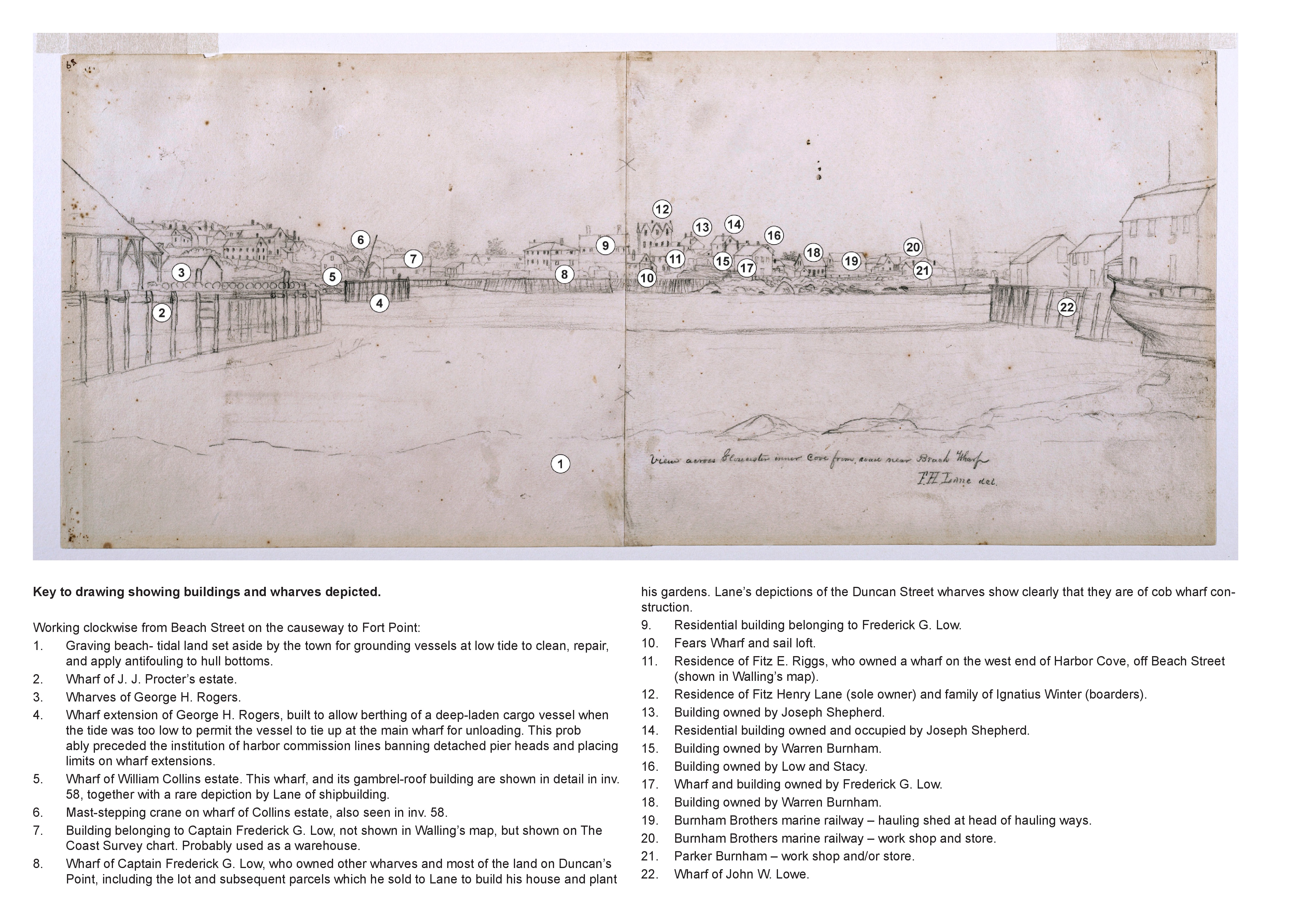
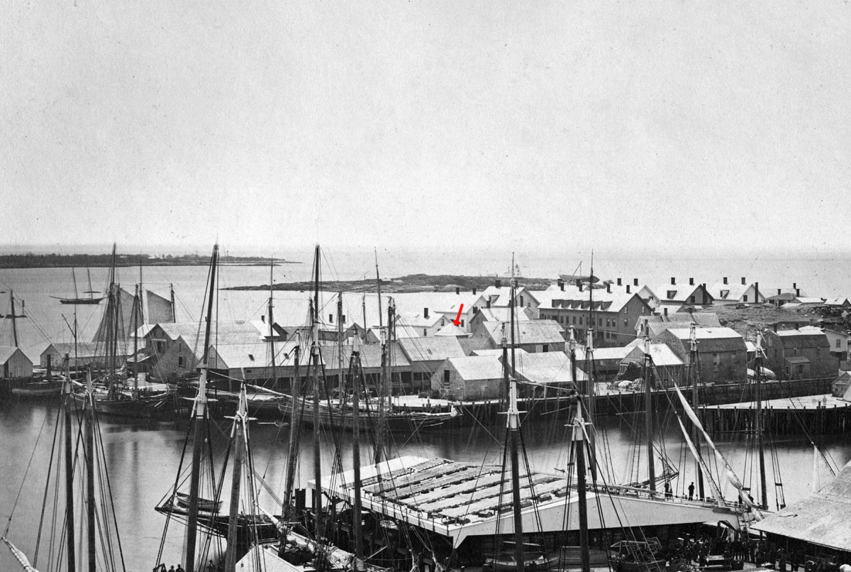
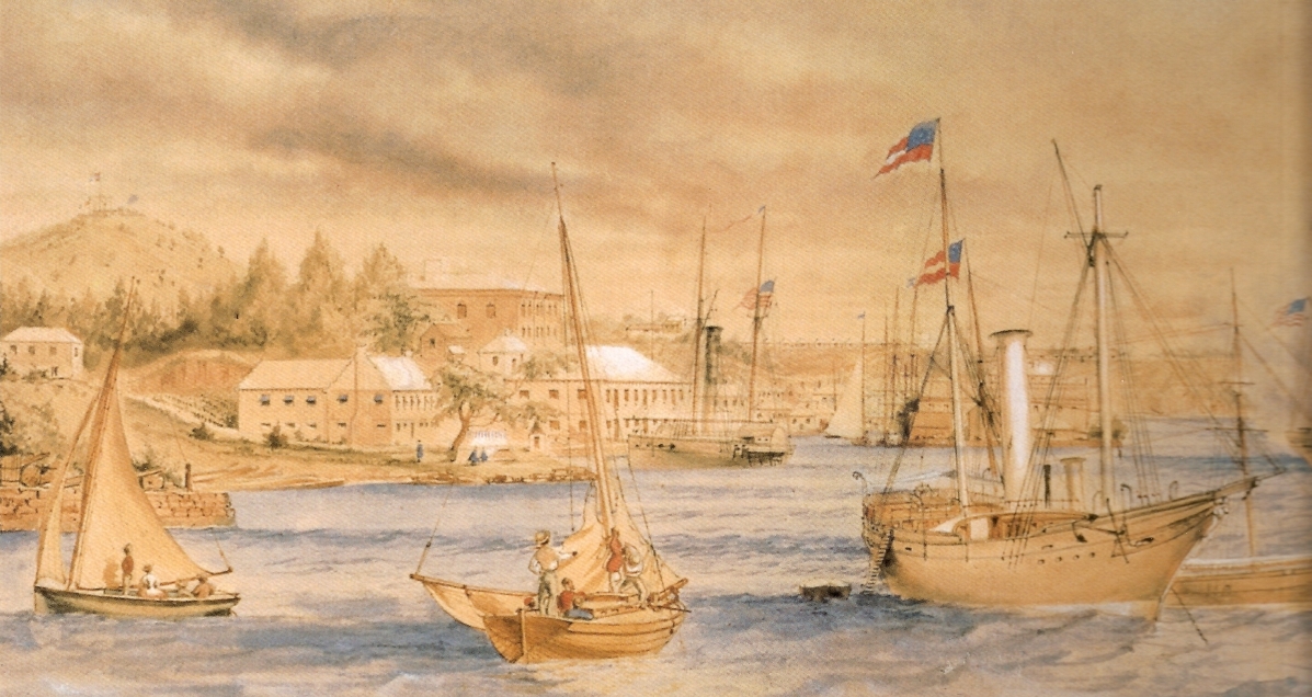
The northeast quarter of Gloucester Harbor is an inlet bounded by Fort Point and Rocky Neck at its entrance. It is further indented by three coves: Harbor Cove and Vincent’s Cove on its north side, and Smith’s Cove on its south side. The shallow northeast end is called Head of the Harbor. Collectively, this inlet with its coves and shallows is called Inner Harbor.
The entrance to Inner Harbor is a wide channel bounded by Fort Point and Duncan’s Point on its north side, and by Rocky Neck on its south side. From colonial times to the late nineteenth century, it was popularly known as “the Stream” and served as anchorage for deeply loaded vessels for “lightering” (partial off-loading). Subsequently it was known as “Deep Hole.”
Of Inner Harbor’s three coves, Harbor Cove (sometimes called “Old Harbor” in later years) was the deepest and most heavily used by fishing vessels in the Colonial Period, and largely dominated by the foreign trade in the first half of the nineteenth century. Its shallow bottom was the undoing of the foreign trade, as larger vessels became too deep to approach its wharves, and the cove returned to servicing a growing fishing fleet in the 1850s.
Vincent’s Cove, a smaller neighbor to Harbor Cove, was bare ground at low tide, and mostly useless for wharfage. Its shoreline was well suited for shipbuilding, and the cove was deep enough at high tide for launching. Records of shipbuilding there prior to the early 1860s have to date not been found.Smith’s Cove afforded wharfage for fishing vessels at its east entrance, as seen in Lane’s lithograph View of the Town of Gloucester, Mass., 1836 (inv. 86). The rest of the cove saw little use until the expansion of the fisheries after 1865.
The Head of the Harbor begins at the shallows surrounding Five Pound Island, extending to the harbor’s northeast end. Lane’s depiction of this area in Gloucester Harbor, 1847 (inv. 23) shows the problems faced by vessel owners at low tide. Despite the absence of deep water, this area saw rapid development after 1865 when a thriving fishing industry needed waterfront facilities, even if they were accessible only at high tide.
– Erik Ronnberg
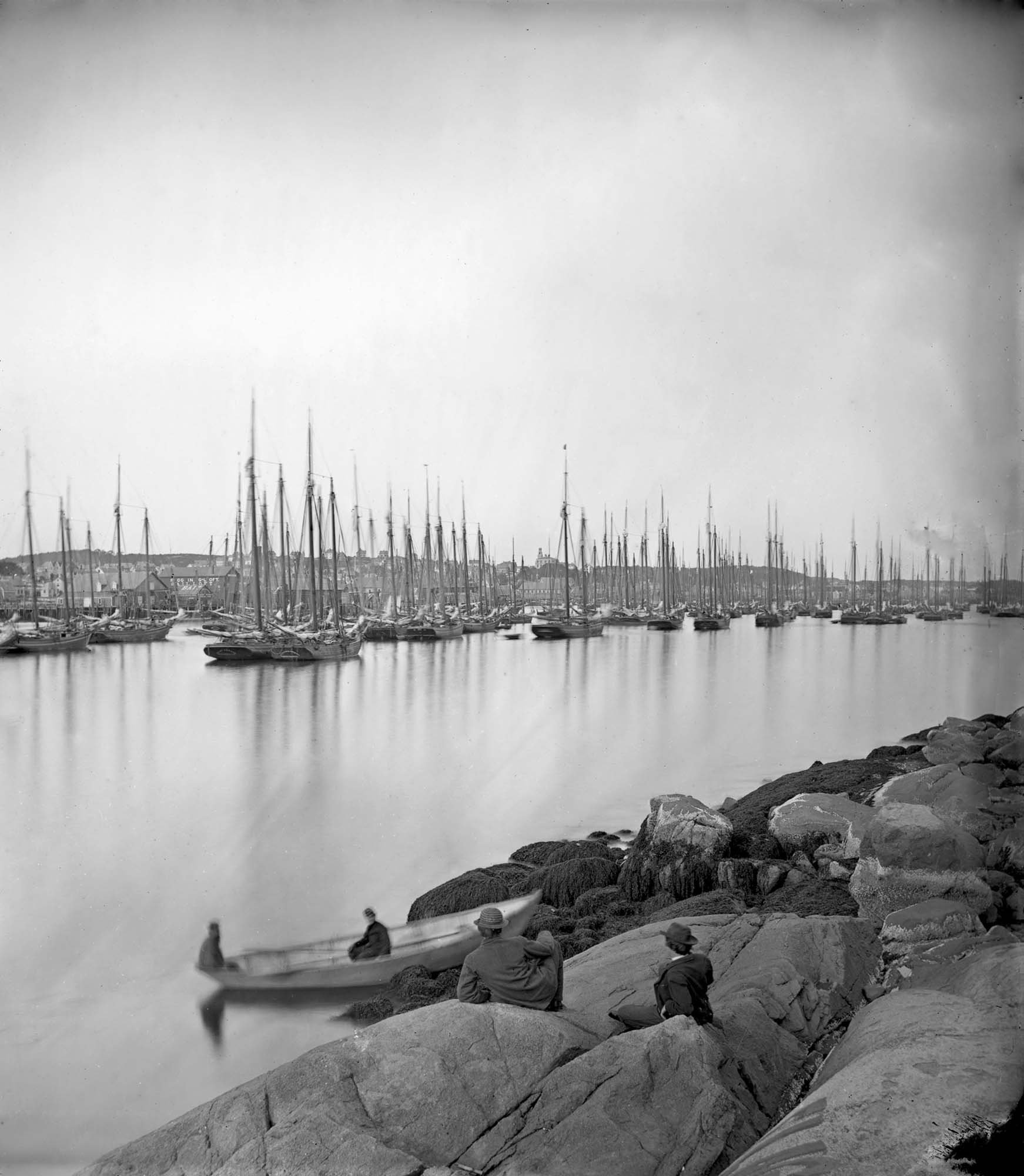
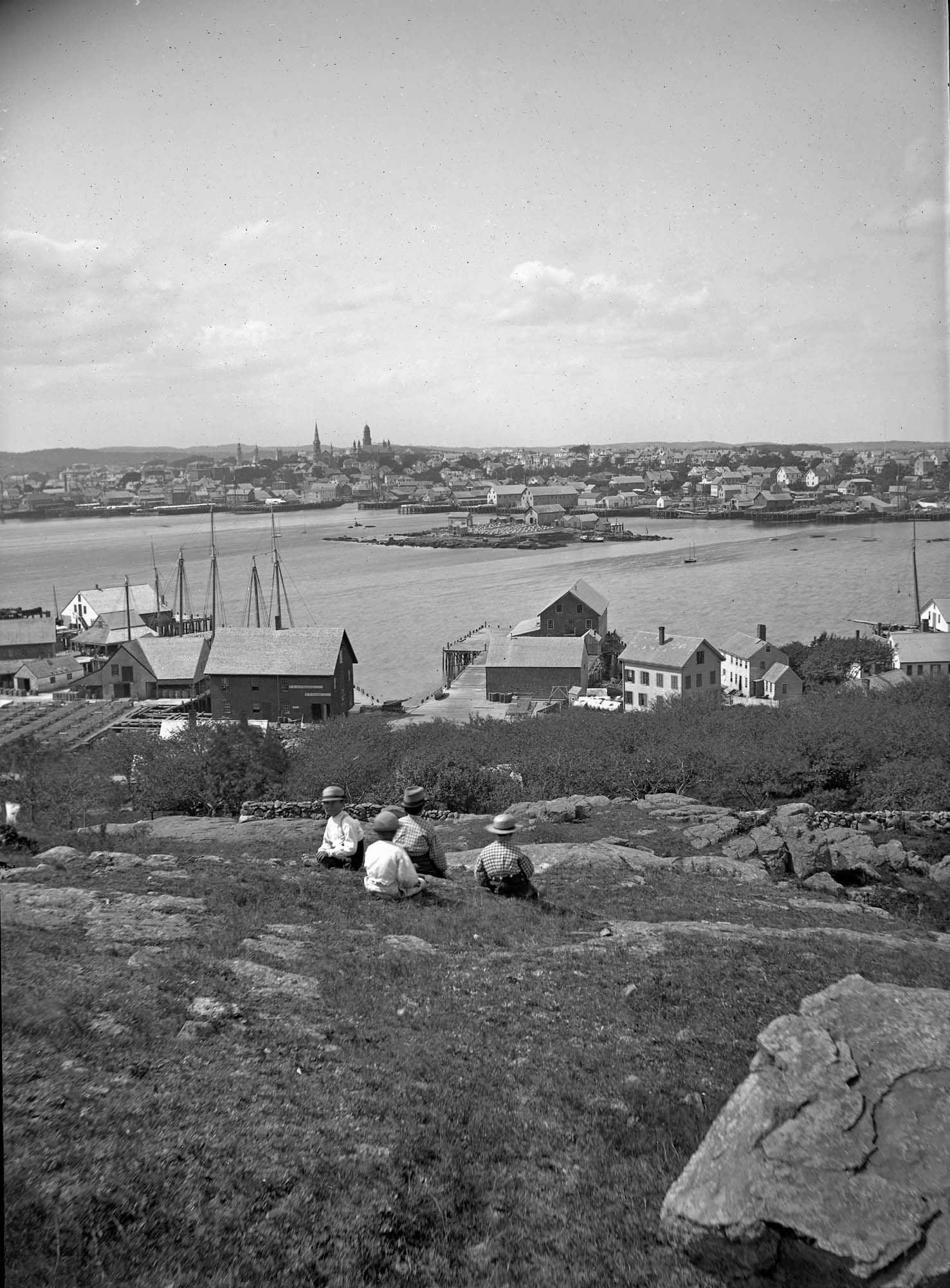
Cape Ann Museum Library & Archive (2013.068)
Schooner fleet anchored in the inner harbor. Looking east from Rocky Neck, Duncan's Point wharves and Lane house (at far left), Sawyer School cupola on Friend Street.
Also filed under: Duncan's Point » // Historic Photographs » // Schooner (Fishing) » // Waterfront, Gloucester »
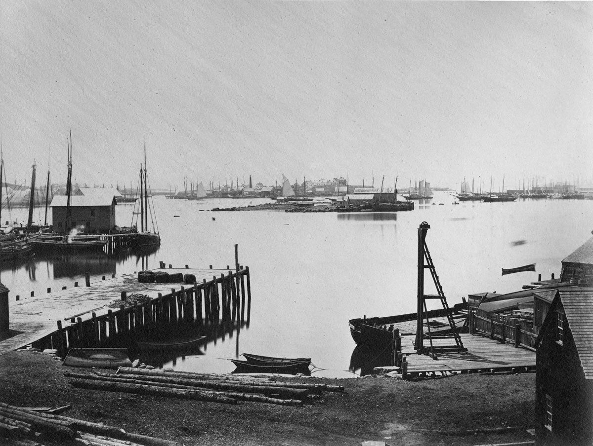
Photograph
Cape Ann Museum Library & Archive
Also filed under: Historic Photographs » // Schooner (Fishing) » // Waterfront, Gloucester »
44 x 34 in.
Henry Francis Walling, Map of the Towns of Gloucester and Rockport, Essex Co. Massachusetts. Philadelphia, A. Kollner, 1851
Cape Ann Museum Library & Archive
"Map of the Towns of Gloucester and Rockport, Massachusetts. H.F. Walling, Civil Engineer. John Hanson, Printer. 1851. Population of Gloucester in 1850 7,805. Population of Rockport in 1850 3,213."
Also filed under: Baptist Church (Old, First, 1830) (Pleasant Street) » // Burnham Brothers Marine Railway » // Duncan's Point » // Five Pound Island » // Flake Yard » // Harbor Methodist Church (Prospect Street) » // Low (Frederick G.) wharves » // Pavilion Hotel » // Procter Brothers » // Ropewalk » // Vincent's Cove » // Western Shore »
4 x 6 in.
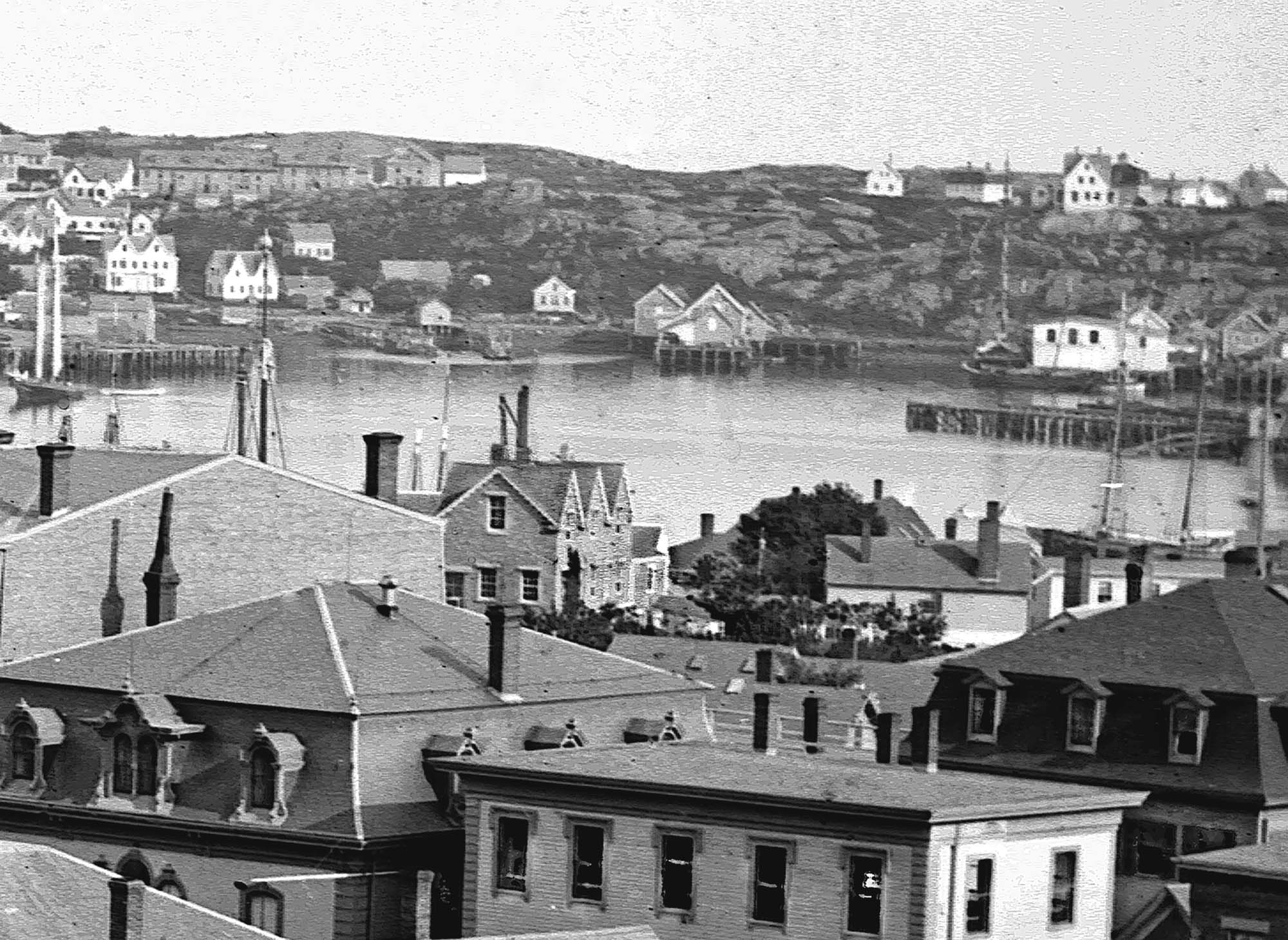
Cape Ann Museum, Benham Collection
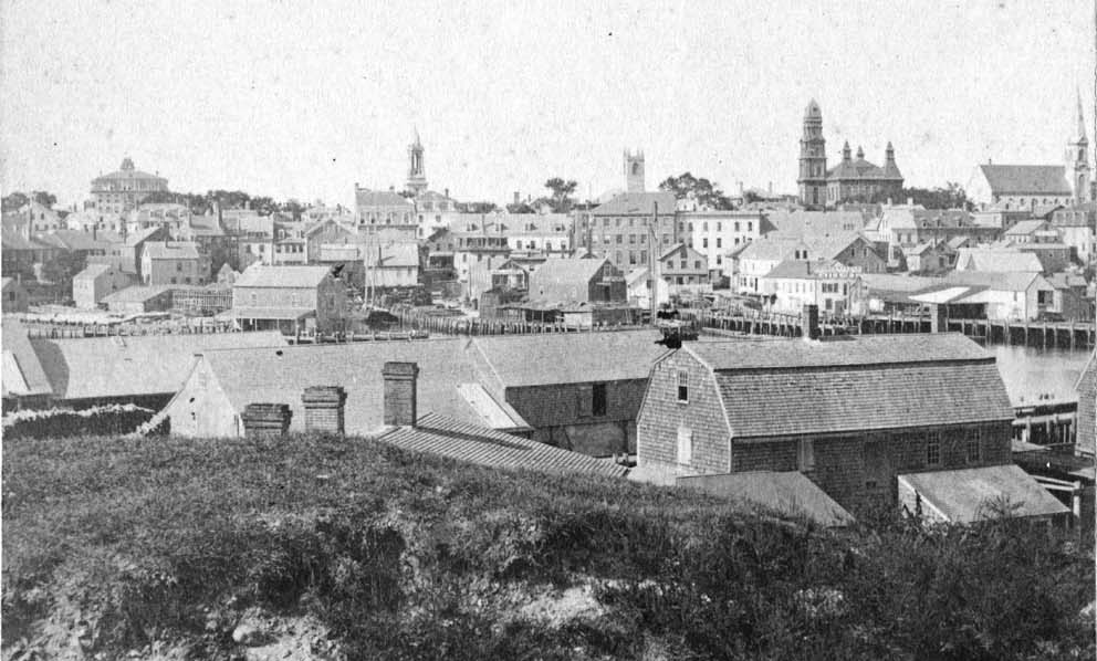
George Steele sail loft, William Jones spar yard, visible across harbor. Photograph is taken from high point on the Fort, overlooking business buildings on the Harbor Cove side.
Also filed under: Fort (The) and Fort Point » // Town House » // Universalist Church (Middle and Church Streets) » // Waterfront, Gloucester »
Lithograph
24 x 38 in.
Gloucester City Archives
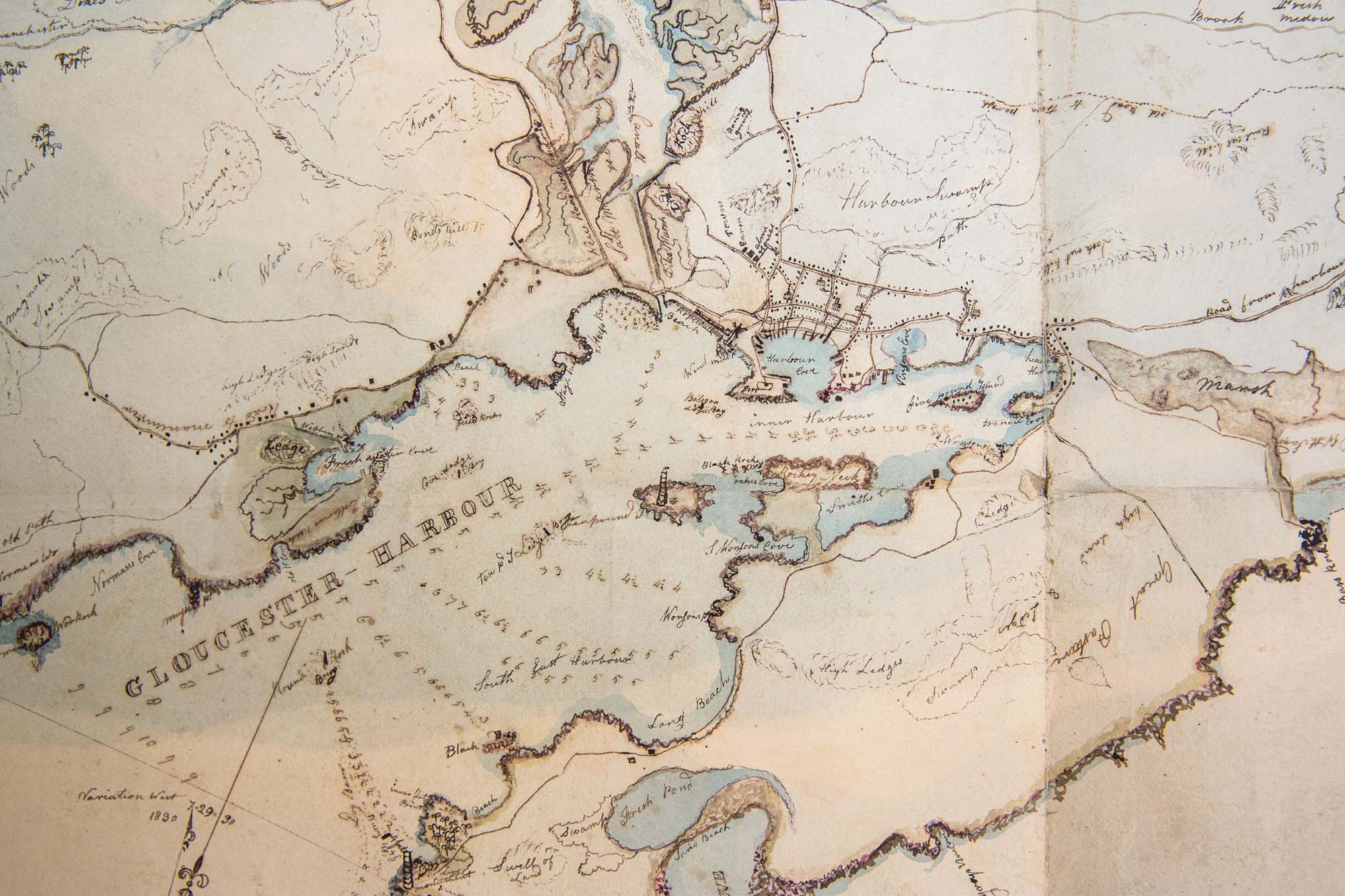
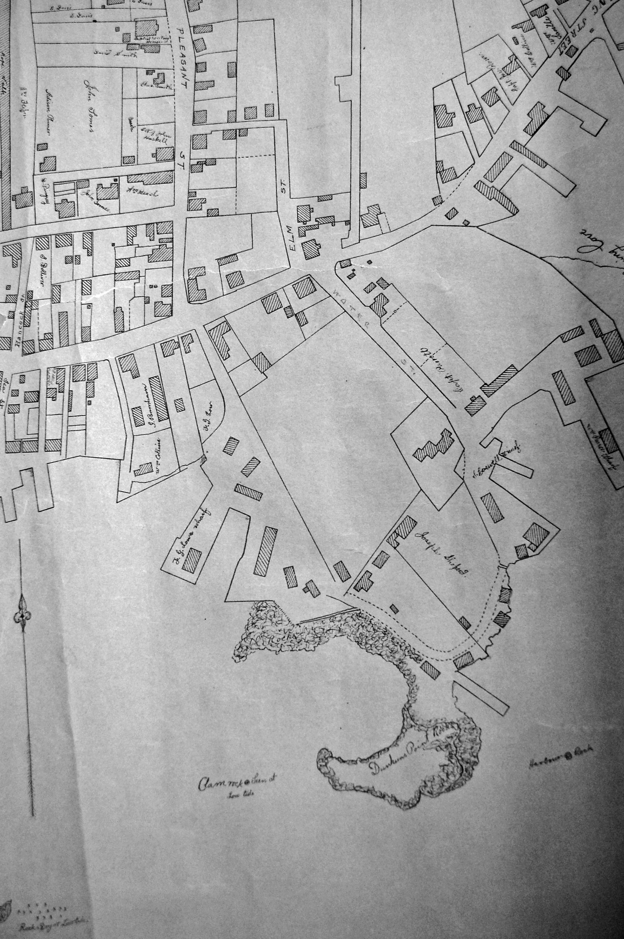
"Drawn on a scale of one hundred feet to an inch. By John Mason 1834–45 from Actual Survey showing every Lott and building then standing on them giving the actual size of the buildings and width of the streets from the Canal to the head of the Harbour & part of Eastern point as farr as Smith's Cove and the Shore of the same with all the wharfs then in use. Gloucester Harbor 1834–35."
This map shows the location of F. E. Low's wharf and the ropewalk. Duncan's Point, the site where Lane would eventually build his studio, is also marked.
The later notes on the map are believed to be by Mason.
Also filed under: Duncan's Point » // Low (Frederick G.) wharves » // Low, Capt. Frederick Gilman » // Maps » // Mason, John » // Residences » // Ropewalk » // Somes, Capt. John »
44 x 34 in.
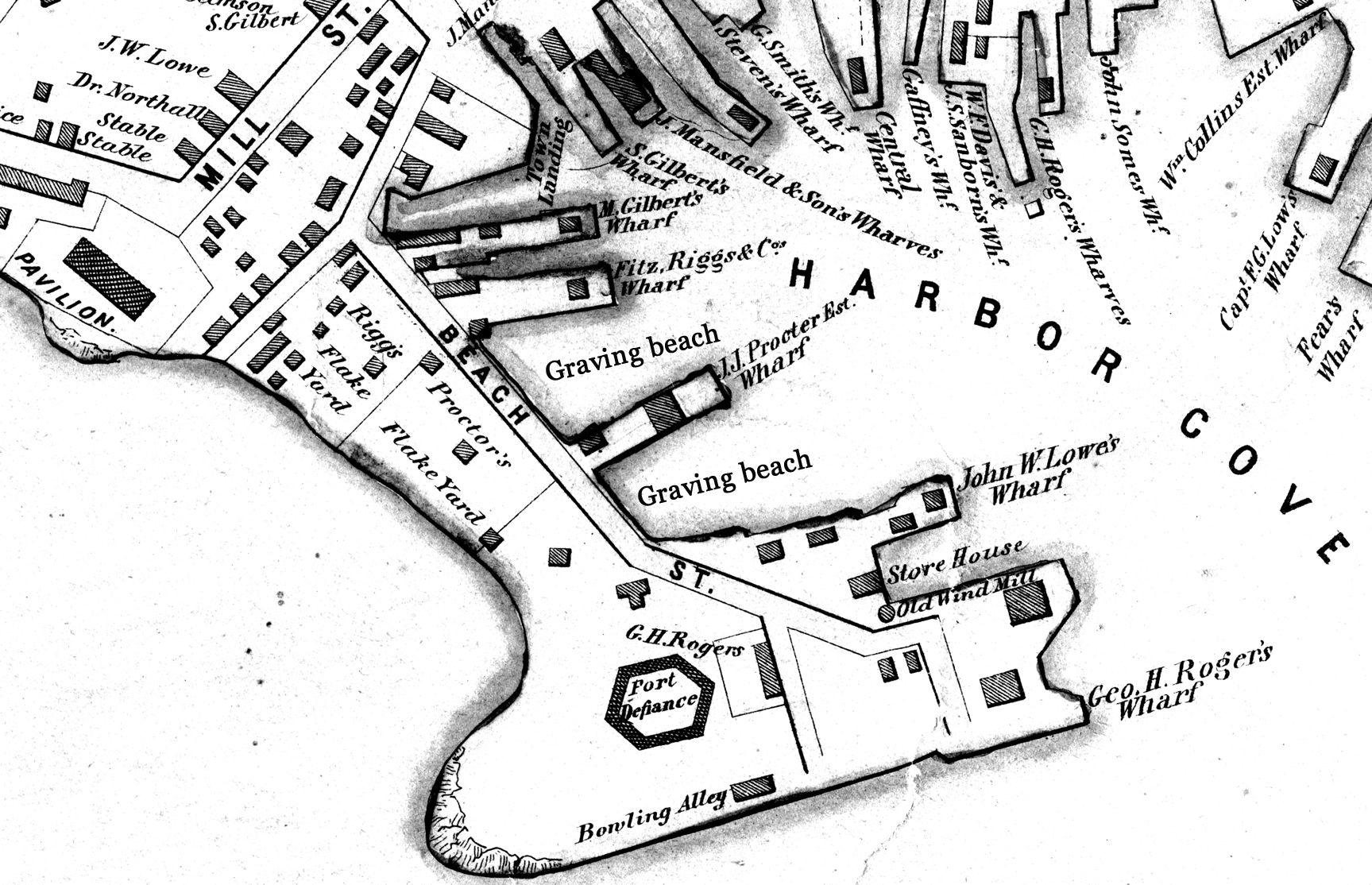
Henry Francis Walling, Map of the Towns of Gloucester and Rockport, Essex Co. Massachusetts. Philadelphia, A. Kollner, 1851
Cape Ann Museum Library & Archive
"Map of the Towns of Gloucester and Rockport, Massachusetts. H.F. Walling, Civil Engineer. John Hanson, Publisher. 1851. Population of Gloucester in 1850 7,805. Population of Rockport in 1850 3,213."
Segment of Harbor Village portion of map showing Collins' and other wharves in the Inner Harbor.
Also filed under: Graving Beach »
Collection of Erik Ronnberg
View related Fitz Henry Lane catalog entries (2) »
Also filed under: Dolliver's Neck » // Fresh Water Cove » // Gloucester Harbor, Outer » // Maps »
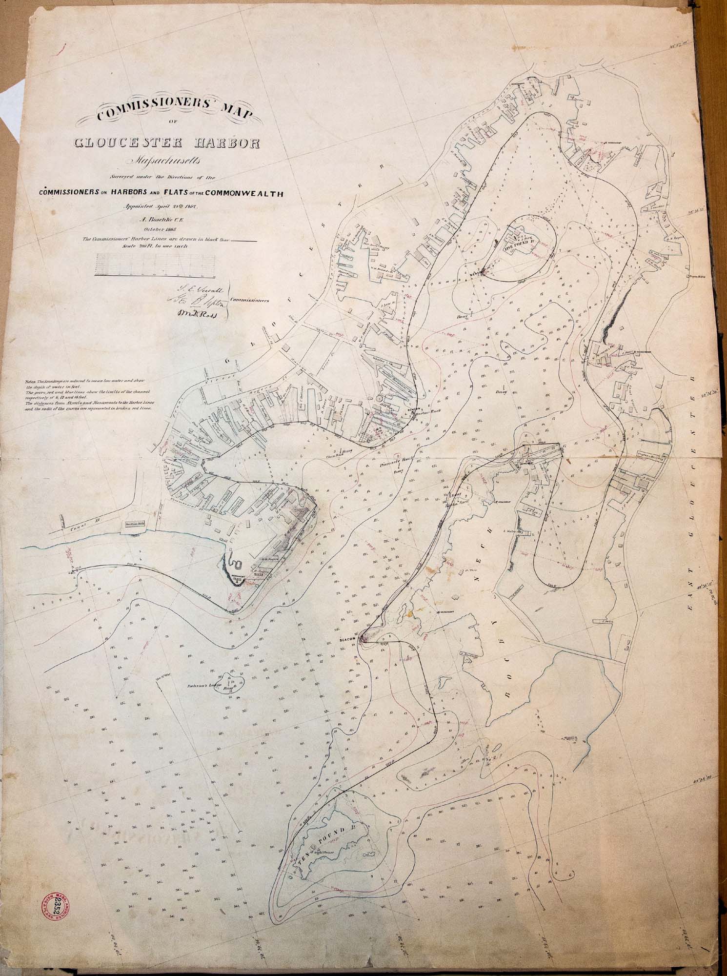
41 x 29 inches
Courtesy of the Massachusetts Archives
Maps and Plans, Third Series Maps, v.66:p.1, no. 2352, SC1/series 50X
.
Also filed under: Burnham Brothers Marine Railway » // Collins's, William (estate wharf) » // Maps » // Rogers's (George H.) wharves »
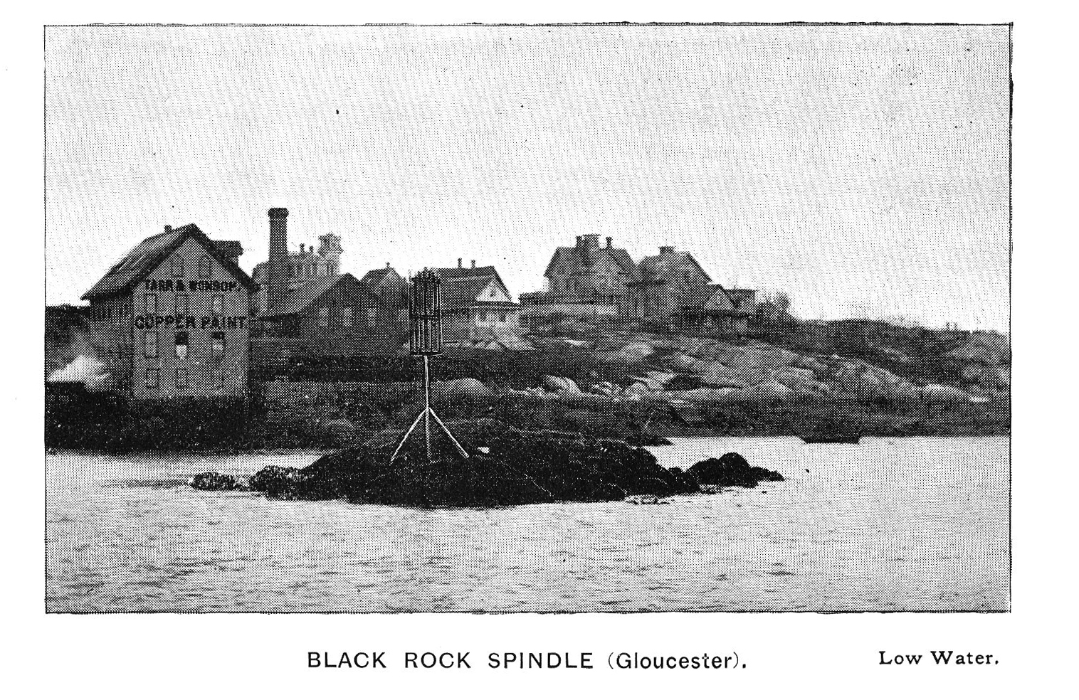
Photograph in The Illustrated Coast Pilot with Sailing Directions. The Coast of New England from New York to Eastport, Maine including Bays and Harbors, published by N. L. Stebbins, Boston
Also filed under: Beacons / Monuments / Spindles »
Cape Ann Museum Library & Archive
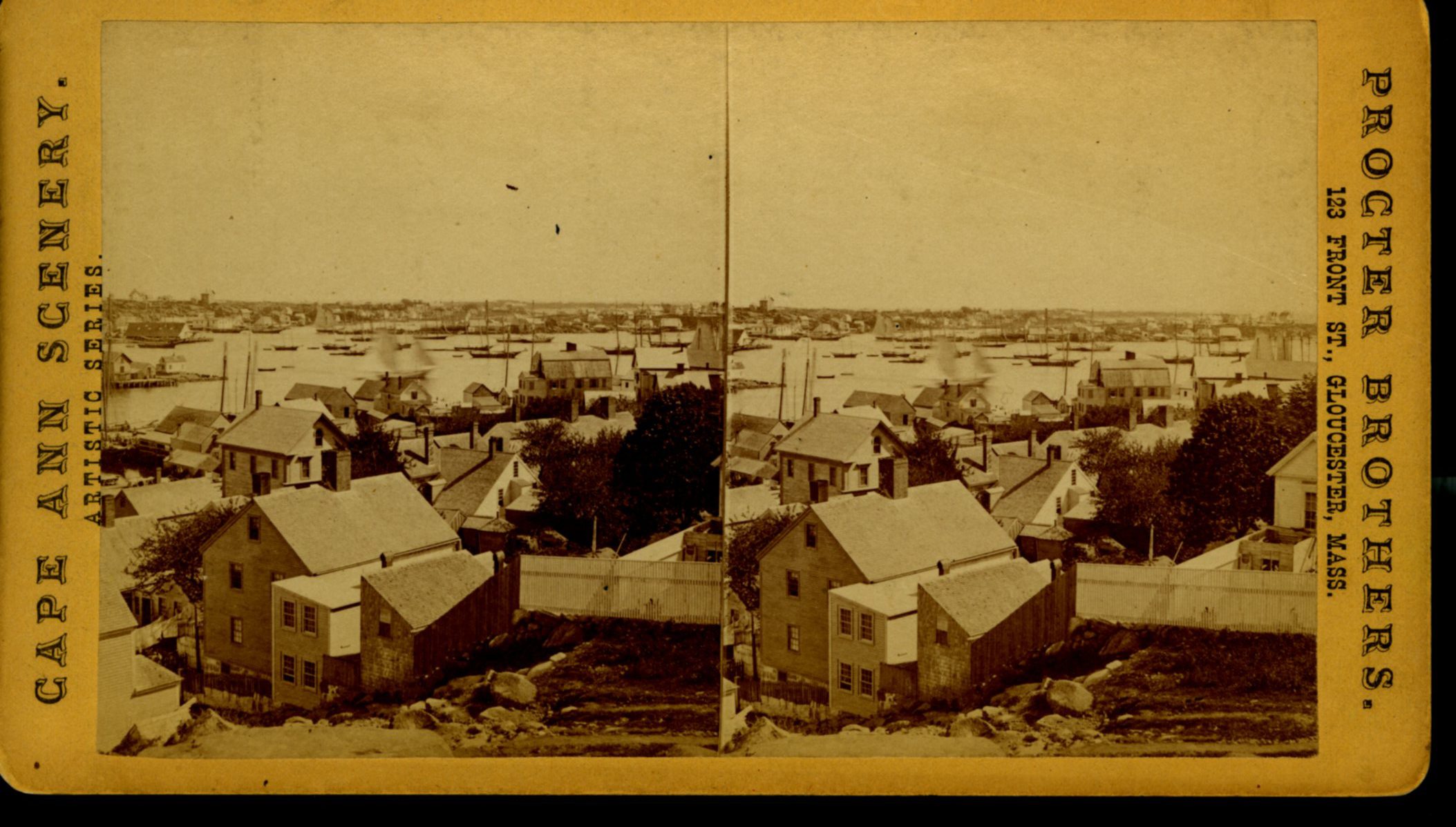
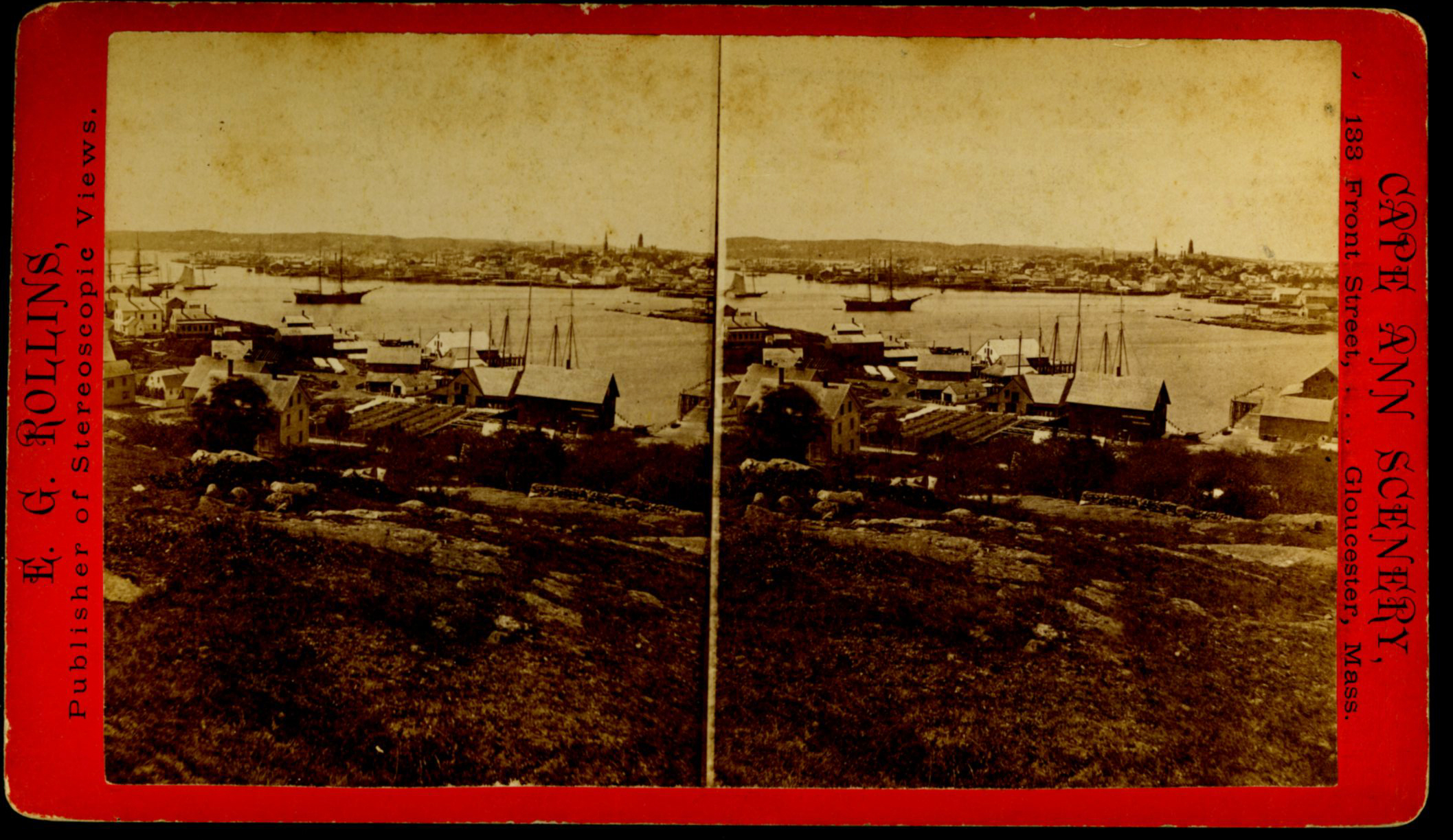
Also filed under: Gloucester – City Views » // Historic Photographs »
Stereograph card
Cape Ann Museum Library & Archive
From East Gloucester looking towards Gloucester.
Also filed under: Gloucester – City Views » // Historic Photographs »
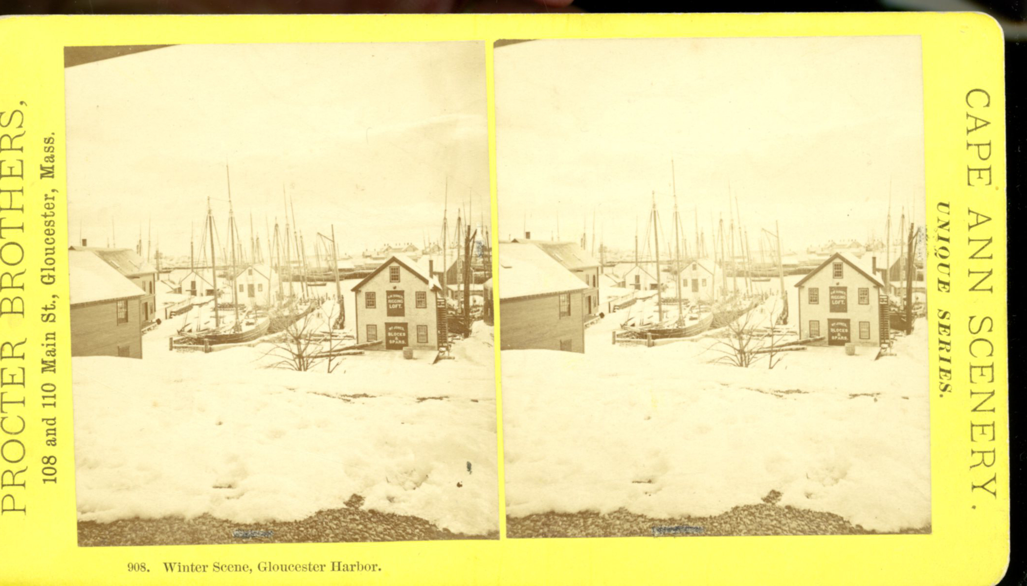
Stereograph card
Cape Ann Museum Library & Archive
Stereo view showing Gloucester Harbor after a heavy snowfall
Also filed under: Historic Photographs » // Waterfront, Gloucester »
Cape Ann Museum Library & Archive
Five Pound Island and Gloucester inner harbor taken from the top of Hammond Street building signs in foreground are for Severance, Carpenter and Crane, and Cooper at Clay Cove.
Also filed under: Five Pound Island »
1852
Oil on canvas
28 x 48 1/2 in.
Cape Ann Museum, Gloucester, Mass., Deposited by the City of Gloucester, 1952. Given to the city by Mrs. Julian James in memory of her grandfather Sidney Mason, 1913 (DEP. 200)
Detail of fishing schooner.
Also filed under: Schooner (Fishing) »
Oil on canvas
34 x 45 3/4 in.
Cape Ann Museum, Gloucester, Mass., Gift of Mrs. Jane Parker Stacy (Mrs. George O. Stacy),1948 (1289.1a)
Detail of party boat.
Also filed under: Party Boat »
Glass plate negative
Cape Ann Museum Library & Archive
Detail from CAHA#00279
The magnificent views of Gloucester Harbor and the islands from the top floor of the stone house at Duncan's Point where Lane had his studio were the inspiration for many of his paintings.
From Buck and Dunlop, Fitz Henry Lane: Family, and Friends, pp. 59–74.
Also filed under: Duncan's Point » // Lane's Stone House, Duncan's Point » // Residences »
Glass plate negative
3 x 4 in.
Cape Ann Museum Library & Archive
#10112
Also filed under: Chebacco Boat / Dogbody / Pinky »
Photograph
Cape Ann Museum Library & Archive
Ignatius Weber's windmill (now defunct) is shown.
Also filed under: Flake Yard » // Fort (The) and Fort Point » // Historic Photographs » // Rogers's (George H.) wharves » // Schooner (Fishing) » // Waterfront, Gloucester » // Windmill »
In John J. Babson, History of the Town Gloucester (Gloucester, MA: Procter Brothers, 1860)
Cape Ann Museum Library & Archives, Gloucester, Mass.
See p. 474.
View related Fitz Henry Lane catalog entries (2) »
Also filed under: Babson History of the Town of Gloucester » // Chebacco Boat / Dogbody / Pinky » // Fort (The) and Fort Point » // Gloucester, Mass. - "Ten Pound Island Light » // Schooner (Coasting / Lumber / Topsail / Packet / Marsh Hay) » // Ten Pound Island »
Essay to come.
The historic New Hampshire port town of Portsmouth has not proven to be the subject of any of Lane's pictures, but there are several for which the topography and buildings suggest a likely identification.
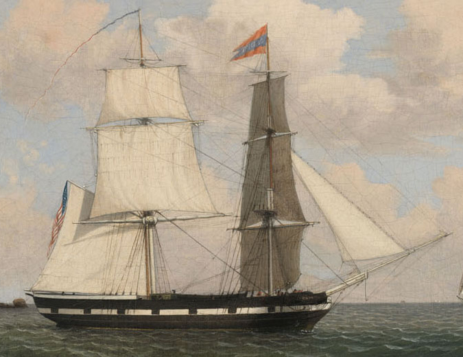
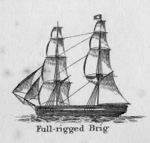
In general, brigs were small to medium size merchant vessels, generally ranging between 80 and 120 feet in hull length. Their hull forms ranged from sharp-ended (for greater speed; see Brig "Antelope" in Boston Harbor, 1863 (inv. 43)) to “kettle-bottom” (a contemporary term for full-ended with wide hull bottom for maximum cargo capacity; see Ships in Ice off Ten Pound Island, Gloucester, 1850s (inv. 44) and Boston Harbor, c.1850 (inv. 48)). The former were widely used in the packet trade (coastwise or transoceanic); the latter were bulk-carriers designed for long passages on regular routes. (1) This rig was favored by Gloucester merchants in the Surinam Trade, which led to vessels so-rigged being referred to by recent historians as Surinam brigs (see Brig "Cadet" in Gloucester Harbor, late 1840s (inv. 13) and Gloucester Harbor at Dusk, c.1852 (inv. 563)). (2)
Brigs are two-masted square-rigged vessels which fall into three categories:
Full-rigged brigs—simply called brigs—were fully square-rigged on both masts. A sub-type—called a snow—had a trysail mast on the aft side of the lower main mast, on which the spanker, with its gaff and boom, was set. (3)
Brigantines were square-rigged on the fore mast, but set only square topsails on the main mast. This type was rarely seen in America in Lane’s time, but was still used for some naval vessels and European merchant vessels. The term is commonly misapplied to hermaphrodite brigs. (4)
Hermaphrodite brigs—more commonly called half-brigs by American seamen and merchants—were square-rigged only on the fore mast, the main mast being rigged with a spanker and a gaff-topsail. Staysails were often set between the fore and main masts, there being no gaff-rigged sail on the fore mast.
– Erik Ronnberg
References:
1. Howard I. Chapelle, The National Watercraft Collection (Washington, DC: Smithsonian Institution, 1960), 64–68.
2. Alfred Mansfield Brooks, Gloucester Recollected: A Familiar History (Gloucester, MA: Peter Smith, 1974), 62–74. A candid and witty view of Gloucester’s Surinam Trade, which employed brigs and barks.
3. R[ichard] H[enry] Dana, Jr., The Seaman's Friend (Boston: Thomas Groom & Co., 1841. 13th ed., 1873), 100 and Plate 4 and captions; and M.H. Parry, et al., Aak to Zumbra: A Dictionary of the World's Watercraft (Newport News, VA: The Mariners’ Museum, 2000), 95.
4. Parry, 95, see Definition 1.
Oil on canvas
17 1/4 x 25 3/4 in.
Cape Ann Museum, Gloucester, Mass., Gift of Isabel Babson Lane, 1946 (1147.a)
Photo: Cape Ann Museum
Detail of brig "Cadet."
Also filed under: "Cadet" (Brig) »
Painting on board
72 x 48 in.
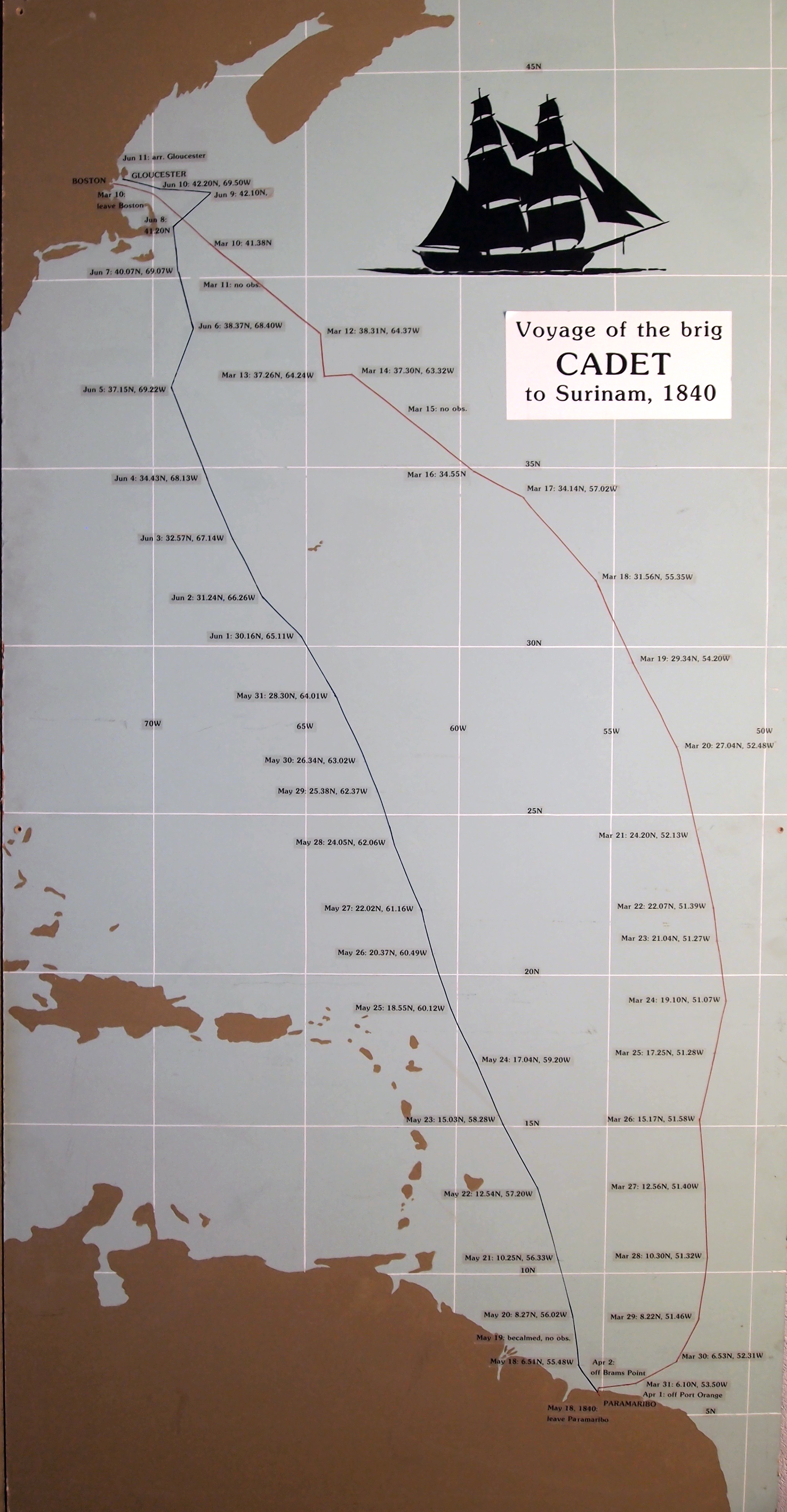
Collection of Erik Ronnberg
Chart showing the voyage of the brig Cadet to Surinam and return, March 10–June 11, 1840.
Also filed under: "Cadet" (Brig) » // Surinam Trade »
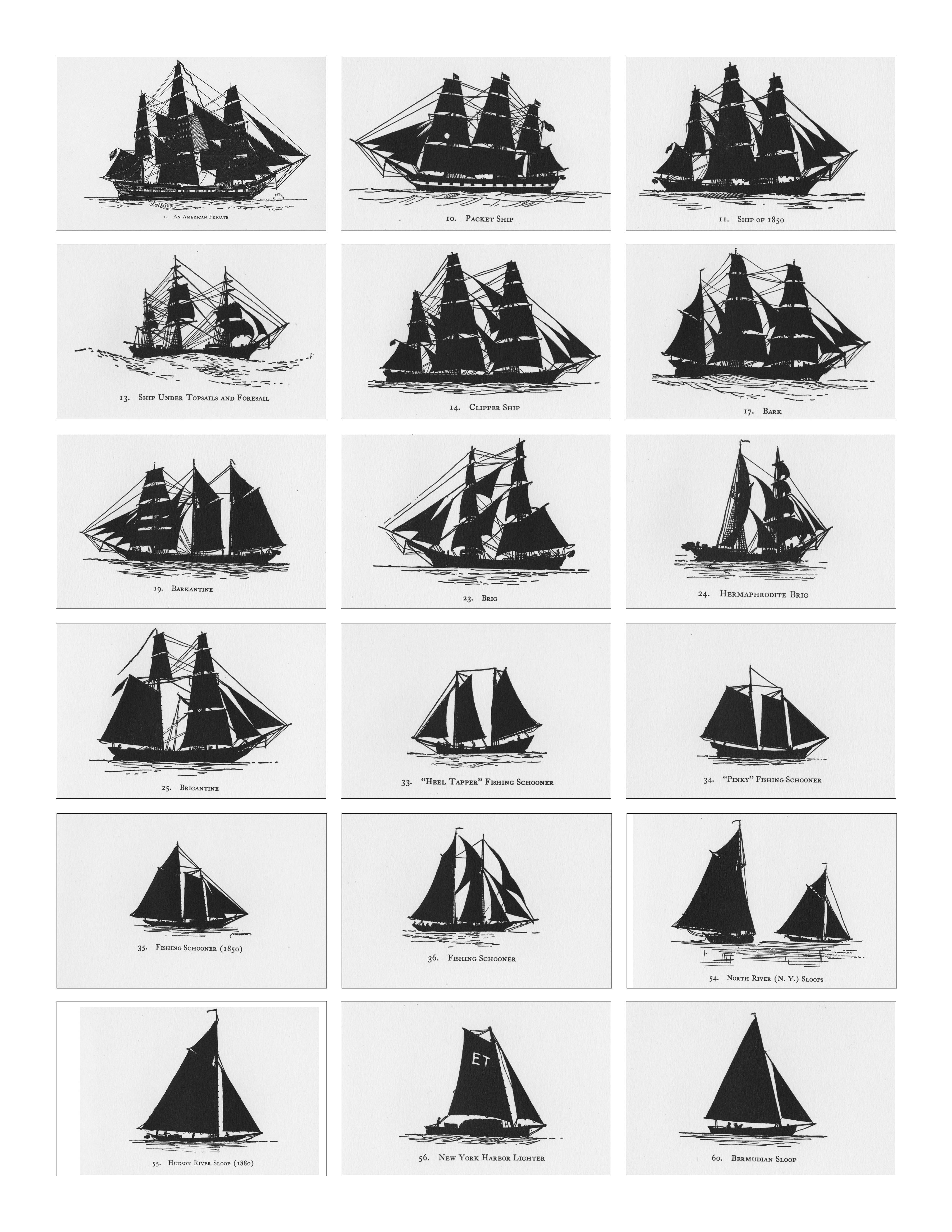
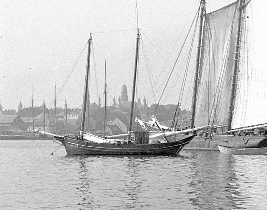
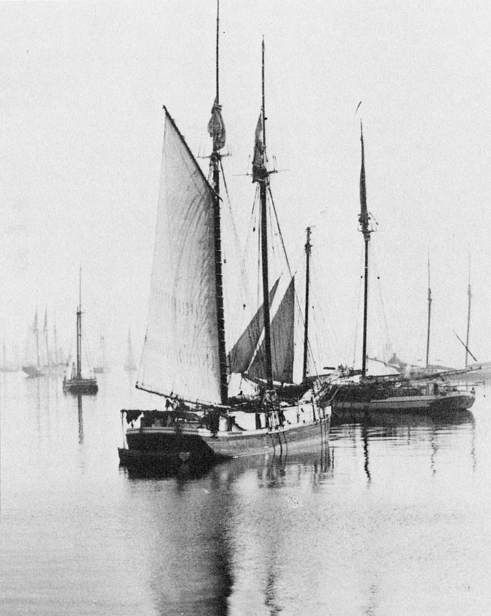
Schooners in Lane’s time were, with few exceptions, two-masted vessels carrying a fore-and-aft rig having one or two jibs, a fore staysail, gaff-rigged fore- and main sails, and often fore- and main topsails. One variant was the topsail schooner, which set a square topsail on the fore topmast. The hulls of both types were basically similar, their rigs having been chosen for sailing close to the wind. This was an advantage in the coastal trade, where entering confined ports required sailing into the wind and frequent tacking. The square topsail proved useful on longer coastwise voyages, the topsail providing a steadier motion in offshore swells, reducing wear and tear on canvas from the slatting of the fore-and-aft sails. (1)
Schooners of the types portrayed by Lane varied in size from 70 to 100 feet on deck. Their weight was never determined, and the term “tonnage” was a figure derived from a formula which assigned an approximation of hull volume for purposes of imposing duties (port taxes) on cargoes and other official levies. (2)
Crews of smaller schooners numbered three or four men. Larger schooners might carry four to six if a lengthy voyage was planned. The relative simplicity of the rig made sail handling much easier than on a square-rigged vessel. Schooner captains often owned shares in their vessels, but most schooners were majority-owned by land-based firms or by individuals who had the time and business connections to manage the tasks of acquiring and distributing the goods to be carried. (3)
Many schooners were informally “classified” by the nature of their work or the cargoes they carried, the terminology coined by their owners, agents, and crews—even sometimes by casual bystanders. In Lane’s lifetime, the following terms were commonly used for the schooner types he portrayed:
Coasting schooners: This is the most general term, applied to any merchant schooner carrying cargo from one coastal port to another along the United States coast (see Bar Island and Mt. Desert Mountains from Somes Settlement, 1850 (inv. 401), right foreground). (4)
Packet schooners: Like packet sloops, these vessels carried passengers and various higher-value goods to and from specific ports on regular schedules. They were generally better-maintained and finished than schooners carrying bulk cargoes (see The Old Fort and Ten Pound Island, Gloucester, 1850s (inv. 30), center; and Gloucester Inner Harbor, 1850 (inv. 240), stern view). (5)
Lumber schooners: Built for the most common specialized trade of Lane’s time, they were fitted with bow ports for loading lumber in their holds (see View of Southwest Harbor, Maine: Entrance to Somes Sound, 1852 (inv. 260)) and carried large deck loads as well (Stage Rocks and the Western Shore of Gloucester Outer Harbor, 1857 (inv. 8), right). Lumber schooners intended for long coastal trips were often rigged with square topsails on their fore masts (see Becalmed Off Halfway Rock, 1860 (inv. 344), left; Maverick House, 1835 (not published); and Lumber Schooner in a Gale, 1863 (inv. 552)). (6)
Schooners in other specialized trades. Some coasting schooners built for carrying varied cargoes would be used for, or converted to, special trades. This was true in the stone trade where stone schooners (like stone sloops) would be adapted for carrying stone from quarries to a coastal destination. A Lane depiction of a stone schooner is yet to be found. Marsh hay was a priority cargo for gundalows operating around salt marshes, and it is likely that some coasting schooners made a specialty of transporting this necessity for horses to urban ports which relied heavily on horses for transportation needs. Lane depicted at least two examples of hay schooners (see Gloucester Harbor, 1850s (inv. 391), left; and Coasting Schooner off Boon Island, c.1850 (inv. 564)), their decks neatly piled high with bales of hay, well secured with rope and tarpaulins.
– Erik Ronnberg
References:
1. Howard I. Chapelle, The History of American Sailing Ships (New York: W.W. Norton & Co., 1935), 258. While three-masted schooners were in use in Lane’s time, none have appeared in his surviving work; and Charles S. Morgan, “New England Coasting Schooners”, The American Neptune 23, no. 1 (DATE): 5–9, from an article which deals mostly with later and larger schooner types.
2. John Lyman, “Register Tonnage and its Measurement”, The American Neptune V, nos. 3–4 (DATE). American tonnage laws in force in Lane’s lifetime are discussed in no. 3, pp. 226–27 and no. 4, p. 322.
3. Ship Registers of the District of Gloucester, Massachusetts, 1789–1875 (Salem, MA: The Essex Institute, 1944). Vessels whose shipping or fishing voyages included visits to foreign ports were required to register with the Federal Customs agent at their home port. While the vessel’s trade or work was unrecorded, their owners and master were listed, in addition to registry dimensions and place where built. Records kept by the National Archives can be consulted for information on specific voyages and ports visited.
4. Howard I. Chapelle, The National Watercraft Collection (Washington, DC: Smithsonian Institution, 1960), 40, 42–43.
5. Ibid., 42–43, 73.
6. Ibid., 74–76.

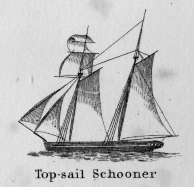
A topsail schooner has no tops at her foremast, and is fore-and-aft rigged at her mainmast. She differs from an hermaphrodite brig in that she is not properly square-rigged at her foremast, having no top, and carrying a fore-and-aft foresail instead of a square foresail and a spencer.
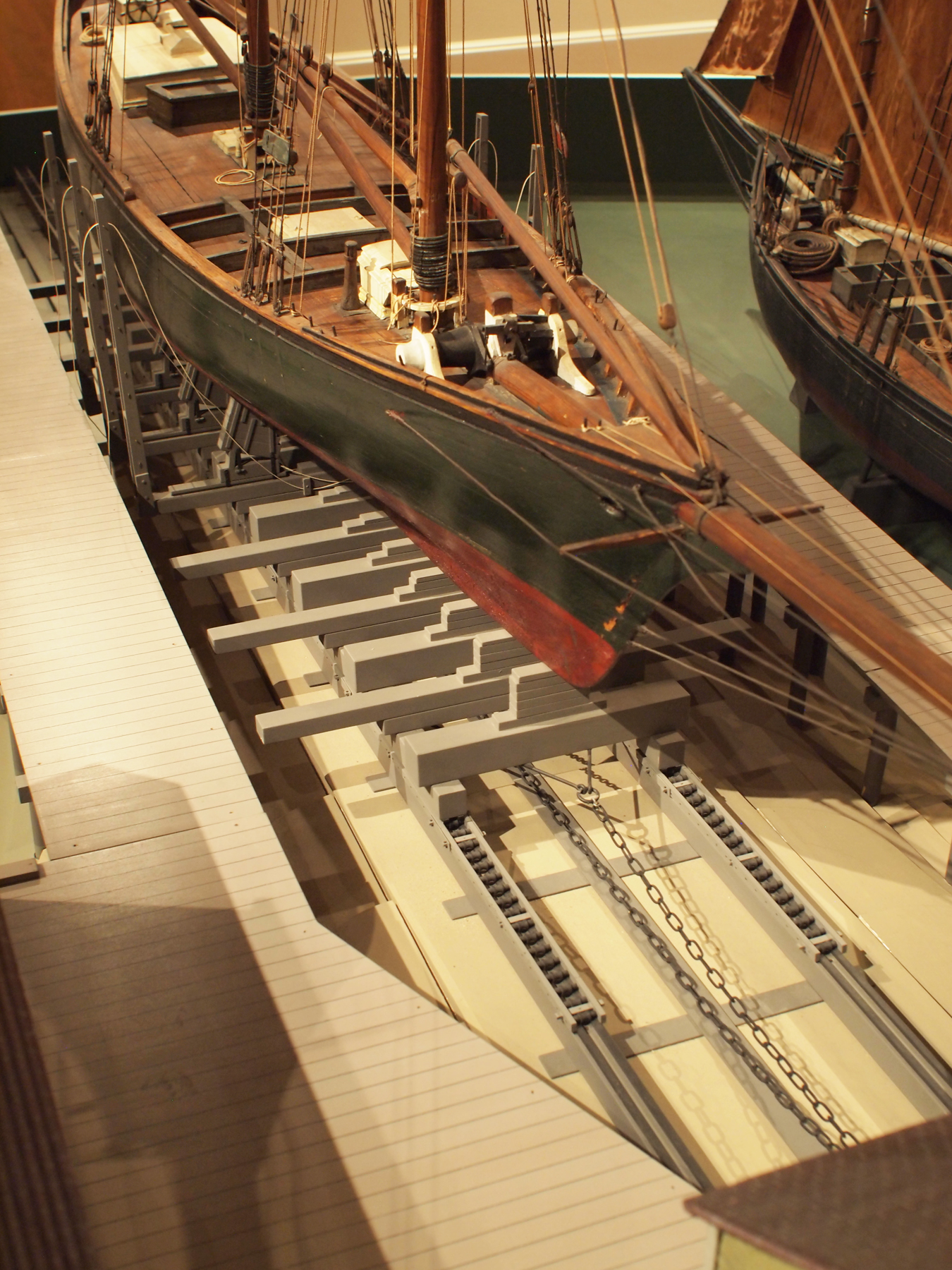
Wood rails, metal rollers, chain; wood cradle. Scale: ½" = 1' (1:24)
Original diorama components made, 1892; replacements made, 1993.
Cape Ann Museum, from Gloucester Chamber of Commerce, 1925 (2014.071)
A schooner is shown hauled out on a cradle which travels over racks of rollers on a wood and metal track.
Also filed under: Burnham Brothers Marine Railway » // Marine Railways »
Glass plate negative
Collection of Erik Ronnberg
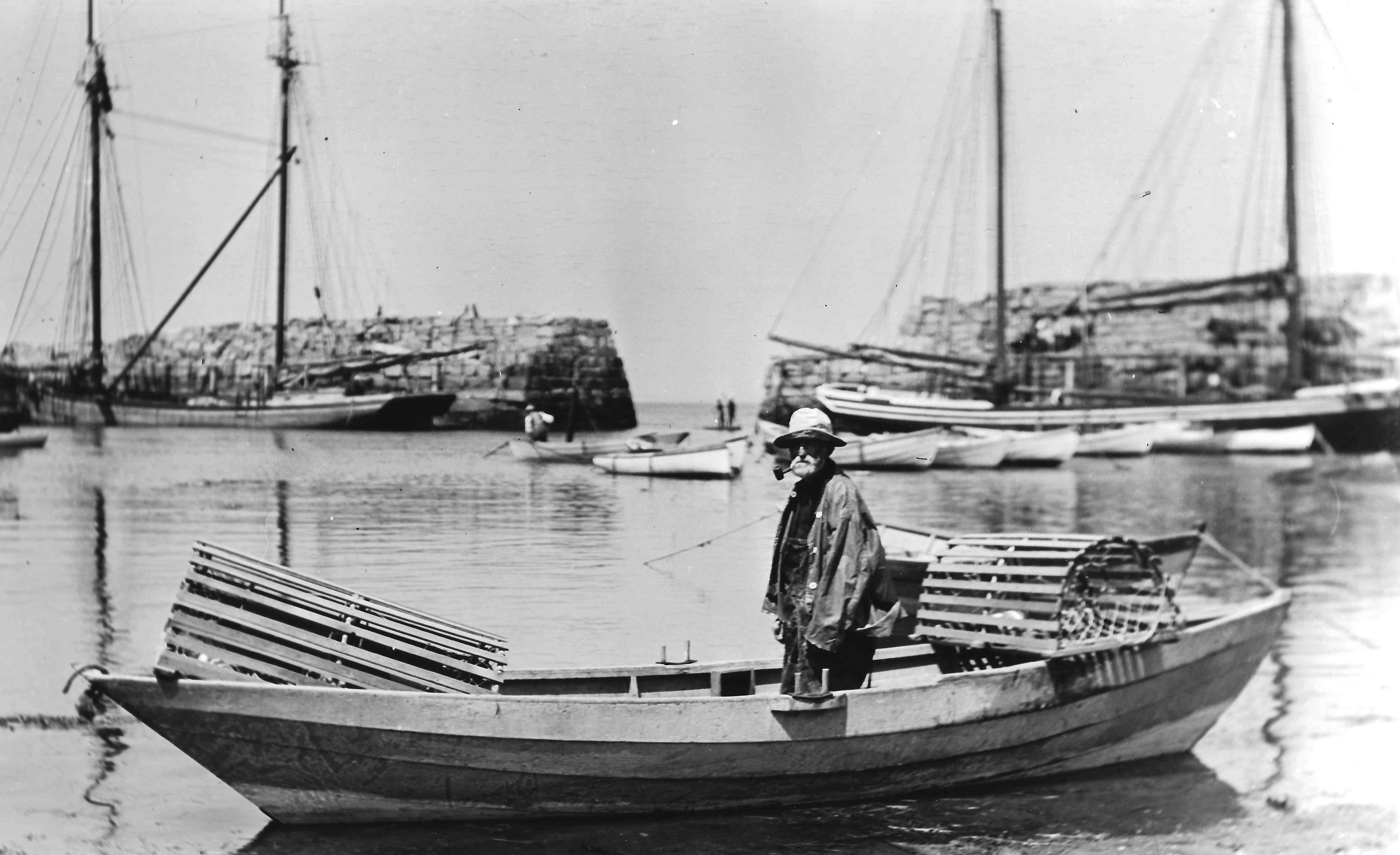
Also filed under: Lobstering »
Details about Maine's lumber trade in 1855, see pp. 250–52
Also filed under: Castine » // Lumber Industry »
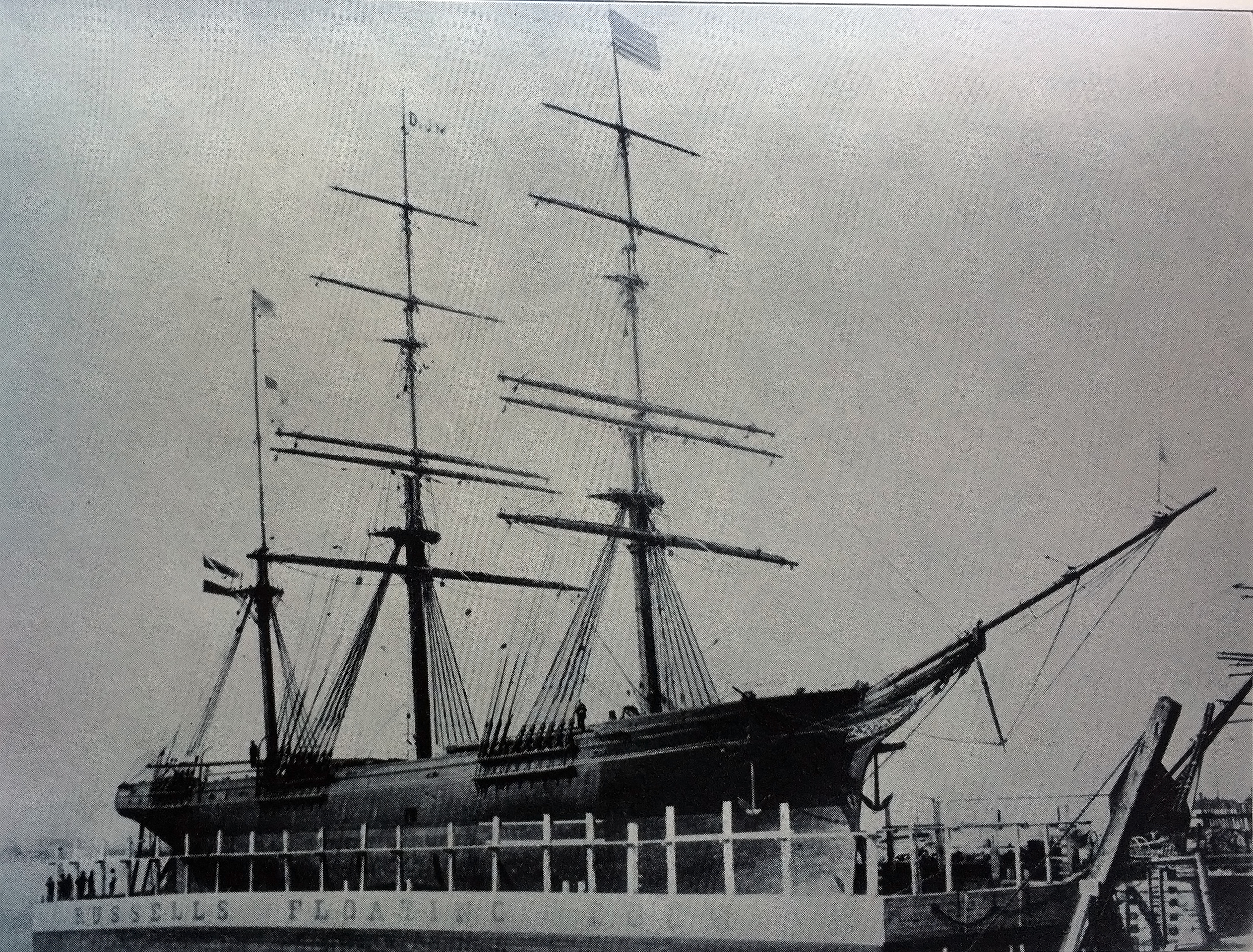
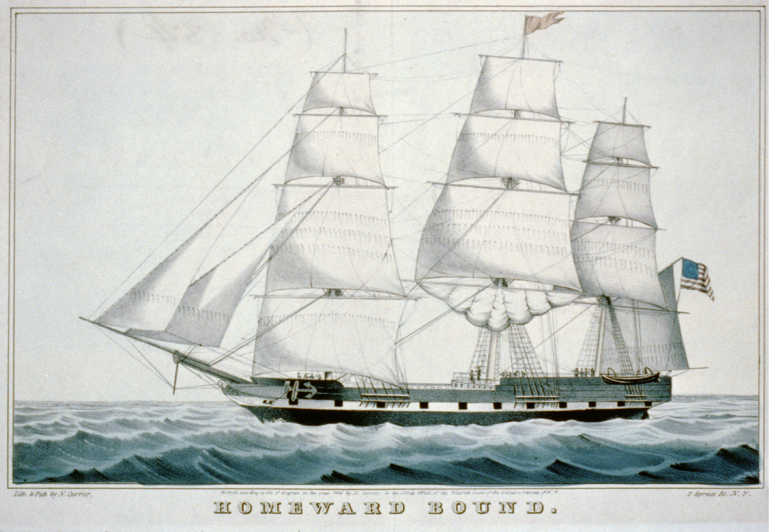
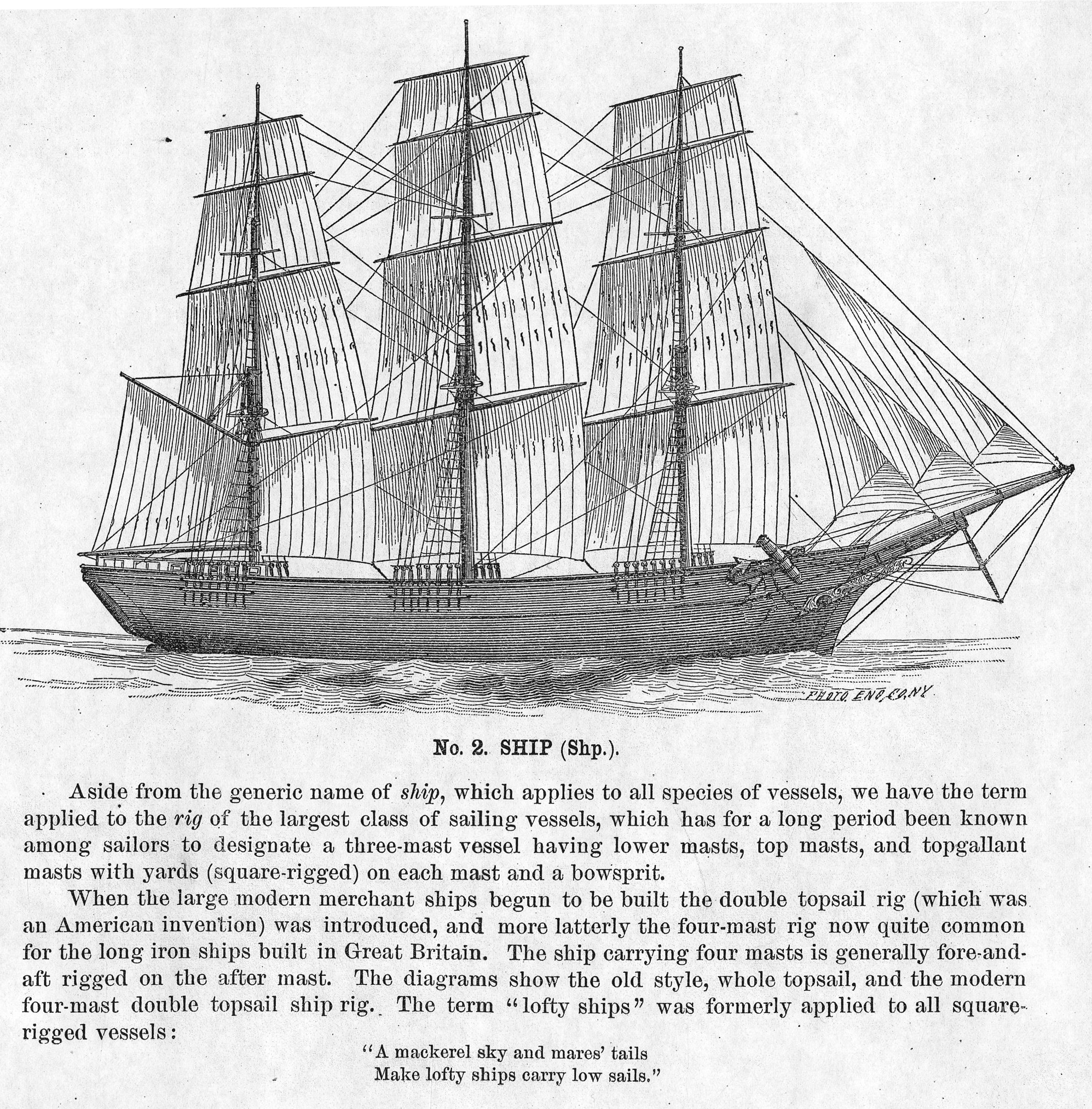
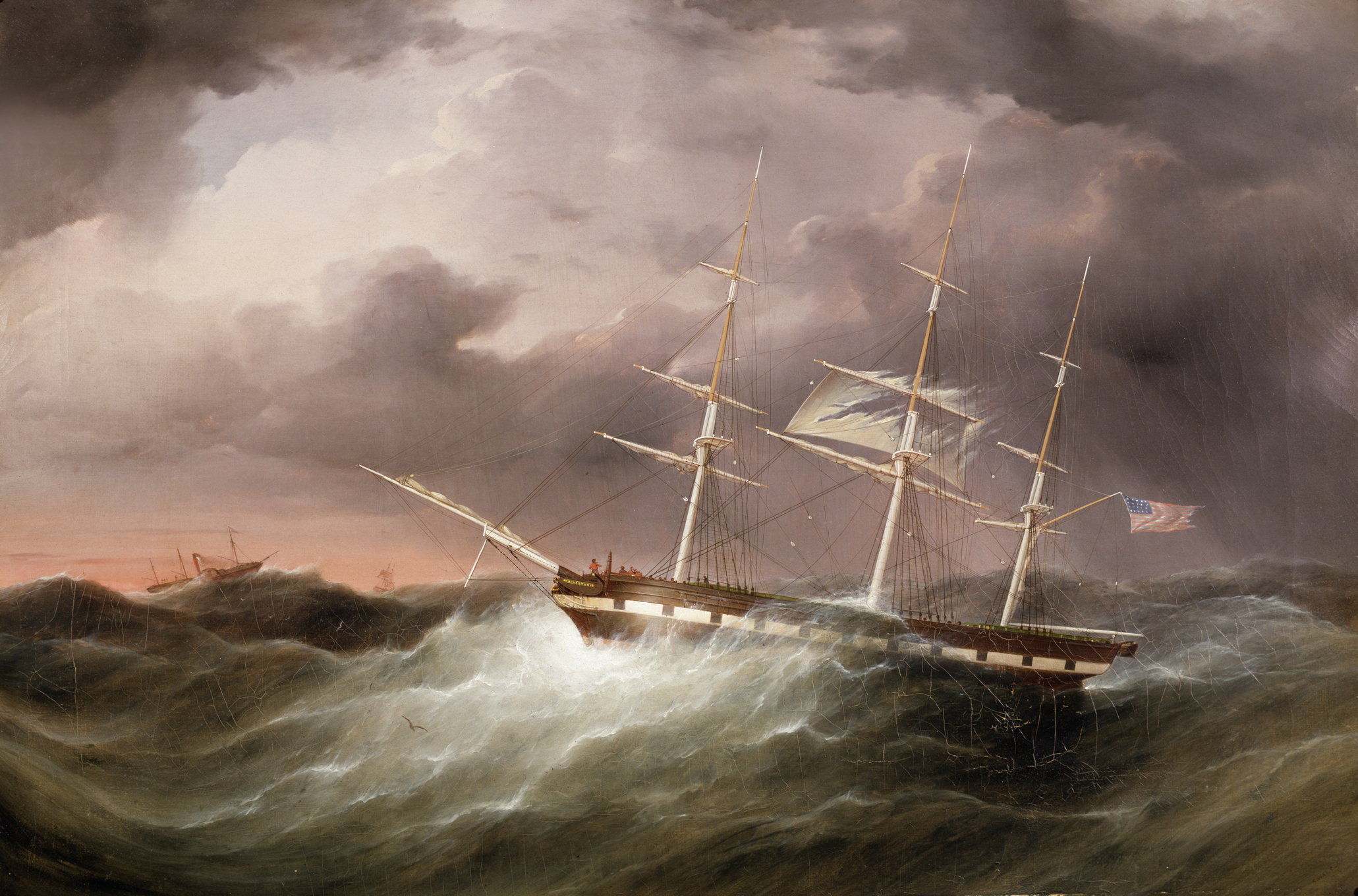
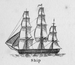
The term "ship," as used by nineteenth-century merchants and seamen, referred to a large three-masted sailing vessel which was square-rigged on all three masts. (1) In that same period, sailing warships of the largest classes were also called ships, or more formally, ships of the line, their size qualifying them to engage the enemy in a line of battle. (2) In the second half of the nineteenth century, as sailing vessels were replaced by engine-powered vessels, the term ship was applied to any large vessel, regardless of propulsion or use. (3)
Ships were often further defined by their specialized uses or modifications, clipper ships and packet ships being the most noted examples. Built for speed, clipper ships were employed in carrying high-value or perishable goods over long distances. (4) Lane painted formal portraits of clipper ships for their owners, as well as generic examples for his port paintings. (5)
Packet ships were designed for carrying capacity which required some sacrifice in speed while still being able to make scheduled passages within a reasonable time frame between regular destinations. In the packet trade with European ports, mail, passengers, and bulk cargos such as cotton, textiles, and farm produce made the eastward passages. Mail, passengers (usually in much larger numbers), and finished wares were the usual cargos for return trips. (6) Lane depicted these vessels in portraits for their owners, and in his port scenes of Boston and New York Harbors.
Ships in specific trades were often identified by their cargos: salt ships which brought salt to Gloucester for curing dried fish; tea clippers in the China Trade; coffee ships in the West Indies and South American trades, and cotton ships bringing cotton to mills in New England or to European ports. Some trades were identified by the special destination of a ship’s regular voyages; hence Gloucester vessels in the trade with Surinam were identified as Surinam ships (or barks, or brigs, depending on their rigs). In Lane’s Gloucester Harbor scenes, there are likely (though not identifiable) examples of Surinam ships, but only the ship "California" in his depiction of the Burnham marine railway in Gloucester (see Three Master on the Gloucester Railways, 1857 (inv. 29)) is so identified. (7)
– Erik Ronnberg
References:
1. R[ichard)] H[enry] Dana, Jr., The Seaman’s Friend, 13th ed. (Boston: Thomas Groom & Co., 1873), p. 121 and Plate IV with captions.
2. A Naval Encyclopaedia (Philadelphia: L. R. Hamersly & Co., 1884), 739, 741.
3. M.H. Parry, et al., Aak to Zumbra: A Dictionary of the World’s Watercraft (Newport News, VA: The Mariners’ Museum, 2000), 536.
4. Howard I. Chapelle, The History of American Sailing Ships (New York: W.W. Norton & Co., 1935), 281–87.
5. Ibid.
6. Howard I. Chapelle, The National Watercraft Collection (Washington, DC: Smithsonian Institution, 1960), 26–30.
7. Alfred Mansfield Brooks, Gloucester Recollected: A Familiar History (Gloucester, MA: Peter Smith, 1974), 67–69.
Photograph
From American Clipper Ships 1833–1858, by Octavius T. Howe and Frederick C. Matthews, vol. 1 (Salem, MA: Marine Research Society, 1926).
Photo caption reads: "'Golden State' 1363 tons, built at New York, in 1852. From a photograph showing her in dock at Quebec in 1884."
Also filed under: "Golden State" (Clipper Ship) »
.jpg)
Oil on canvas
24 x 35 in.
Peabody Essex Museum, Salem, Mass.
Walters' painting depicts the "Nonantum" homeward bound for Boston from Liverpool in 1842. The paddle-steamer is one of the four Clyde-built Britannia-class vessels, of which one is visible crossing in the opposite direction.
View related Fitz Henry Lane catalog entries (2) »
Also filed under: Packet Shipping » // Walters, Samuel »
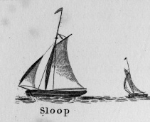
Sloops are one-masted sailing vessels which, in American examples, set fore-and-aft sails but usually no square sails. Thus, staysails, or jibs, are set from the fore stay(s) and a quadrilateral mainsail is set from the mast and spread by a gaff and a boom. The larger sloops would often set a triangular topsail over the main sail. (1)
The sloops depicted by Lane were used in various coastal trades, each with its own requirements, which dictated the sizes and details of their hulls and rigs. Most elegant were the packet sloops, which transported passengers, mail, and higher value goods between specific ports on regular schedules. They usually measured between sixty and seventy-five feet on deck, as dictated by anticipated shipping volume. Finely finished, they usually had stern galleries—a row of windows across the transom with ornamental moldings—and varied color schemes. Examples of packet sloops are in Gloucester Harbor from Rocky Neck, 1844 (inv. 14) (center, middle ground) and Study of Ships, 1851 (inv. 141) (foreground), both of which probably made trips between Gloucester and Boston, or Gloucester and Newburyport. (2)
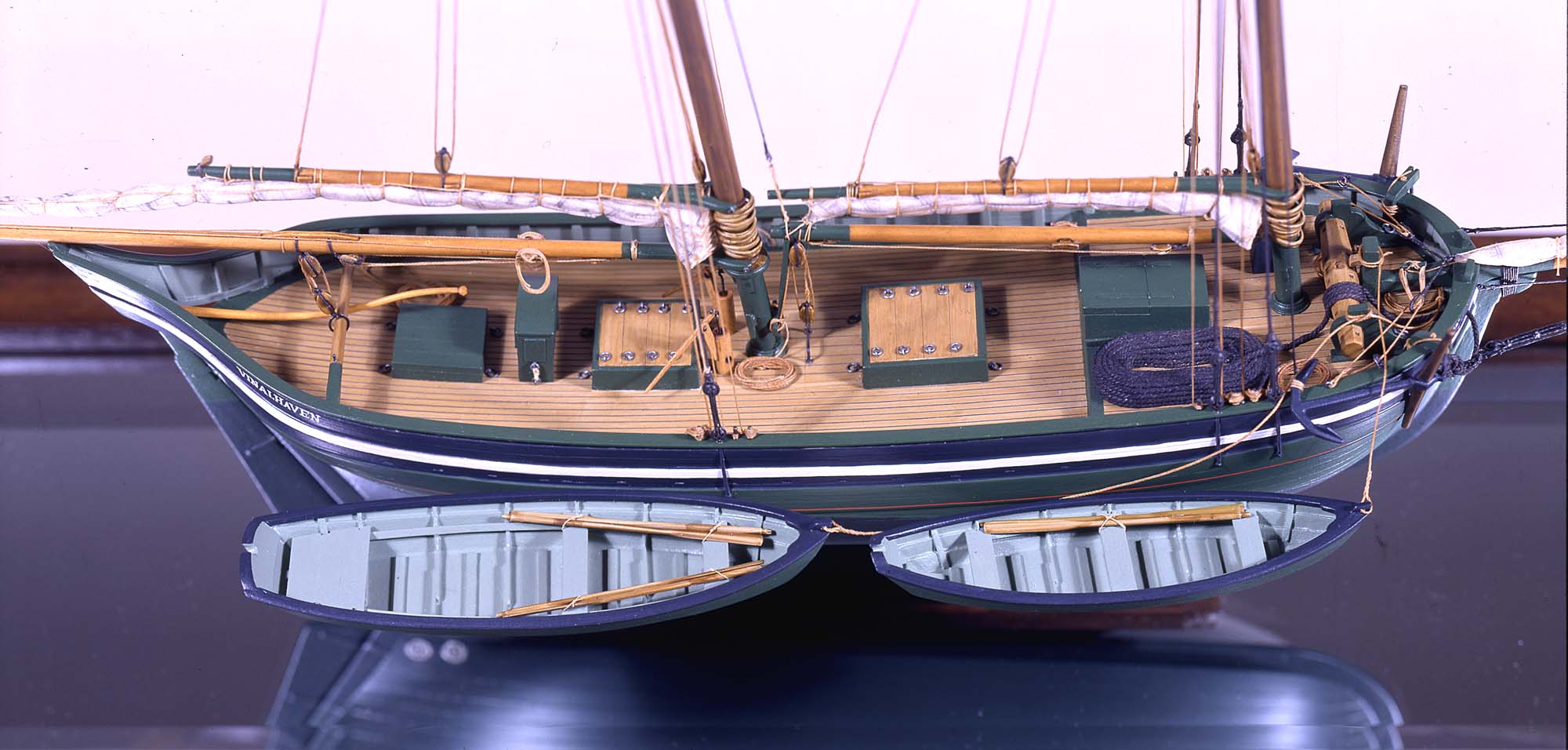
Another specialized sloop of similar size was the stone sloop, used to ship granite blocks from stone-loading piers around Cape Ann to other ports. They were similar in rig to packet sloops, but of heavier construction with greater hold capacity and absence of decoration. Their stout appearance was augmented by simple color schemes, or even tarred topsides, reflecting the wear and strain imposed by their heavy cargos. Lane depicted these vessels in his painting of Fresh Water Cove from Dolliver's Neck, Gloucester, Early 1850s (inv. 45), with a sloop (at left) preparing to load at wharf-side, and another (at right) sailing out with a cargo. (3)
Sloops of the more work-a-day sort are the most commonly seen examples in Lane’s paintings, most of them appearing in his views of Boston Harbor. Usually deep-loaded and looking weather-worn, they contrast sharply with the packet- and clipper ships which dominate the scene. Sloops of this type are rarely seen in Lane’s paintings of Gloucester Harbor and the Maine coast, although they were certainly needed for short-distance transportation (see Bear Island, Northeast Harbor, 1855 (inv. 24), View of Camden Mountains from Penobscot Bay, c.1852 (inv. 207), Sunrise on the Maine Coast, Mount Desert Island, 1856 (inv. 295)). For coastal Maine, lack of railroads for heavier freight and greater distances between ports made the use of schooners with larger carrying capacity a greater necessity. (4)
In Lane’s views of New York Harbor, a regional sloop variant, the Hudson River Sloop, appears in New York Harbor, c.1855 (inv. 46) (bow view, left) and A Calm Sea, c.1860 (inv. 6) (stern view, right). This type had become prominent in the Hudson River packet trade between New York City, Albany, and beyond to points north and west as far as the eastern terminus of the Erie Canal. Large vessels for their rigs, they were well-finished and well-kept, reflecting pride of ownership and rivalry among their owners and crews. (5)
– Erik Ronnberg
References:
1. A Naval Encyclopaedia (Philadelphia: L.R. Hamersly & Co., 1884. Reprint: Detroit, MI: Gale Research Company, 1971), 59. See first definition of "sloop" and definition of "sloop-rigged."
2. Robert Greenhalgh Albion, William A. Baker, and Benjamin Woods Labaree, New England and the Sea (Mystic, CT: Mystic Seaport Museum, 1972; reprinted in 1994), 127–28.
3. Howard I. Chapelle, The History of American Sailing Ships (New York: W.W. Norton & Co., 1935), 300–02.
4. Ibid., 300.
5. Ibid., 298–300.
A Naval Encyclopaedia:
Dictionary of nautical words and phrases
Special Articles on Naval Art and Science
Philadelphia: L.R. Hamersly & Co.
'Mudian, "Mugian, or Bermudian. A boat special to the Bermuda islands, usually decked, with the exception of a hatch; from 2 to 20 tons burden; it is short, of good beam, and great draft of water abaft, the stem and keel forming a curved line. It carries an immense quantity of ballast. Besides a long main- and short jib-boom, it has a long, taperking, raking mast, stepped just over the forefoot, generally unsupported by shrouds or stays; on it a jib-headed mainsail is hoisted to a height of twice, and sometimes three times, the length of the keel. This sail is triangular, stretched at its foot by a long boom. The only other sail is a small foresail or jib. They claim to be the fastest craft in the world for working to windward in smooth water, it being recorded of one that she made five miles dead to windward in the hour during a race; and though they may be laid over until they fill with water, they will not capsize.
St. George's Historical Society
Detail of painting of St. George's Harbour, Bermuda, during US Civil War, with a Confederate blockade runner anchored in the foreground.
Also filed under: Puerto Rico »
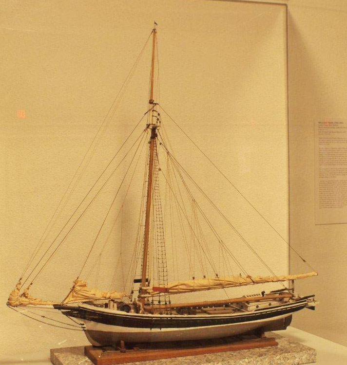
Wood, metal, cordage, cloth, paint.
Scale: ¼ in. = 1ft. (1:48)
Cape Ann Museum. Gift of Roland and Martta Blanchet (1997.17.3)
Although built in 1890 and larger than the stone sloops of Lane’s time, the "Albert Baldwin’s" hull form, rig, and loading boom are very similar to those of the 1840s and 1850s.
Also filed under: Granite Quarrying / Shipping » // Ship Models »
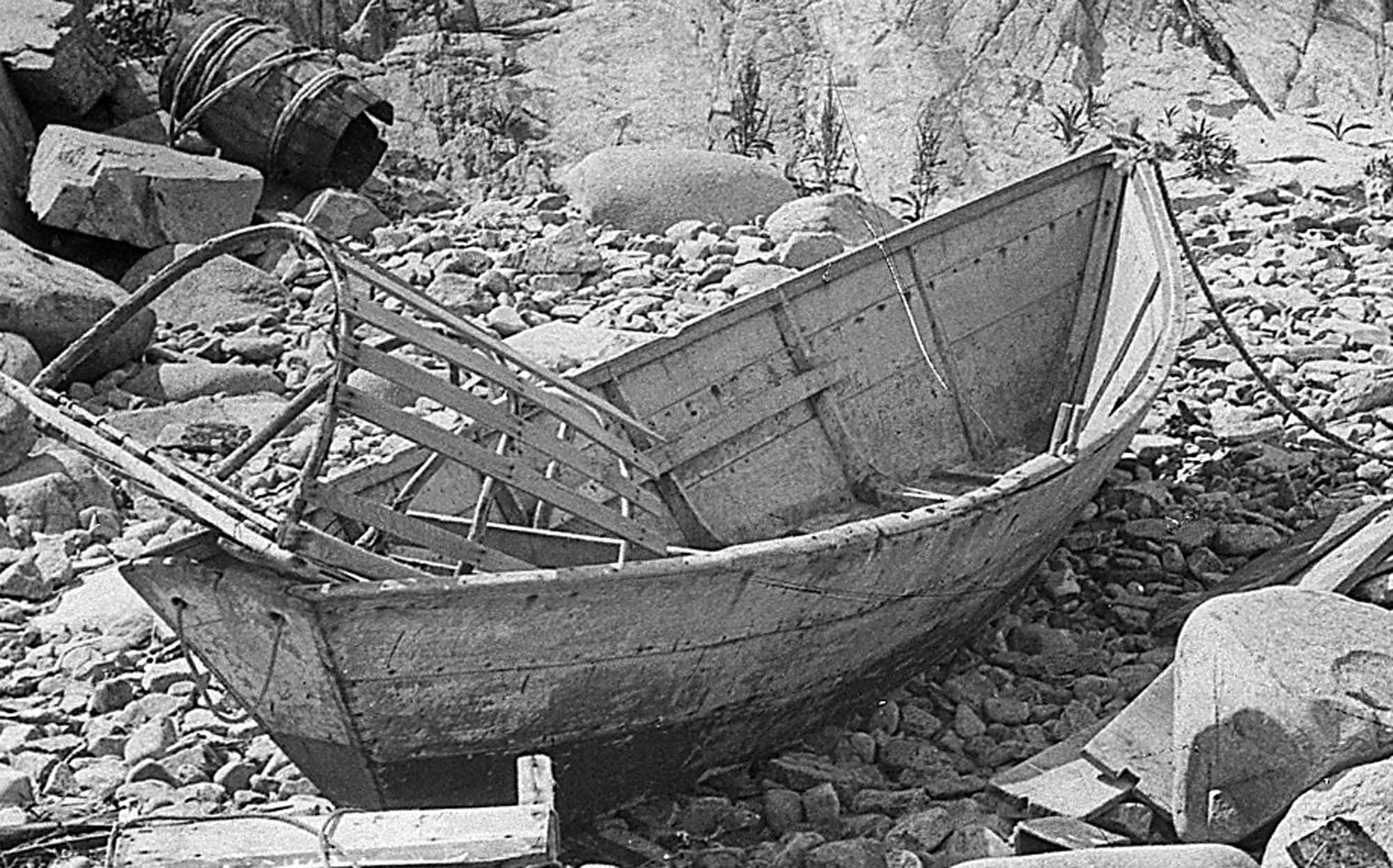
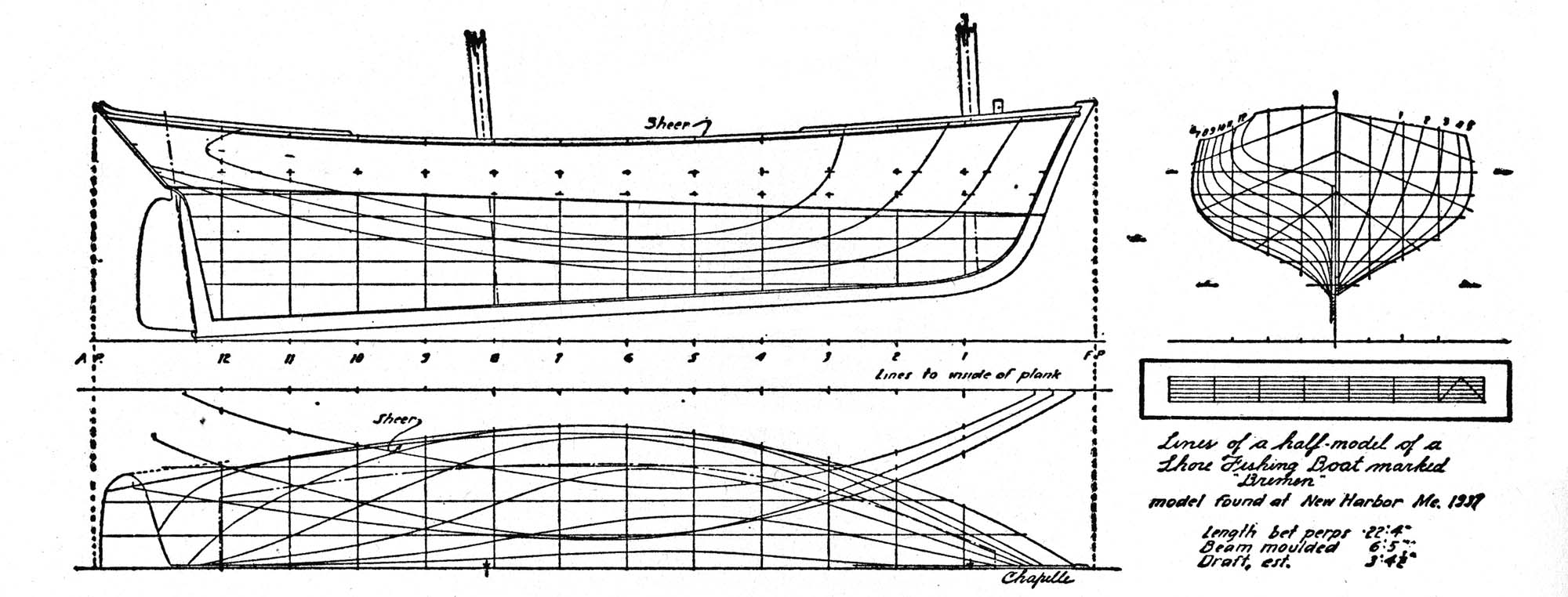
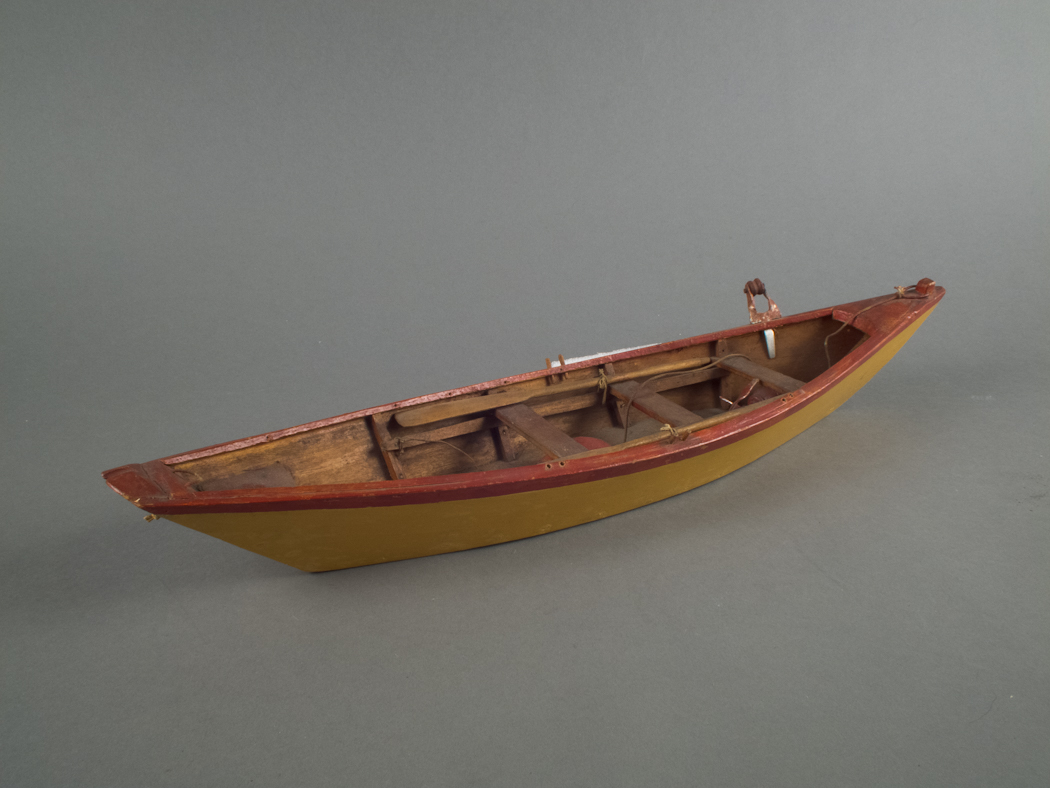
The term “wherry”—variously spelled—has a long history with many hull types, some dating from the fifteenth century. (1) The version known to Lane appears to be a variant of the dory hull form and probably was developed by French and English fishermen in the Newfoundland fisheries before 1700. (2) From that time, the wherry and the dory co-evolved, their similarities the result of their construction, their differences the result of use. By the early nineteenth century, their forms reached their final states, if fragments of contemporary descriptions are any indication. (3)
By the time Lane was depicting wherries, the type (as used for fishing) resembled a larger, wider version of a dory. The extra width was due to greater bottom width (both types had flat bottoms), with a wider transom at the stern instead of the narrow, v-shaped “tombstone.” These features are easy to see in one of his drawings (see Three Men, One in a Wherry (inv. 225)) and a painting (see Sunrise through Mist, 1852 (inv. 98)), the latter depicted alongside a dory, clearly showing the differences.
No published descriptions of the uses of wherries on Cape Ann in Lane’s time have come to light, but an example in broadside view offers one use. In Becalmed Off Halfway Rock, 1860 (inv. 344), a pinky (in right foreground) has a dory and a wherry in tow, the latter loaded with a gill net for catching mackerel. (4) The greater size of the wherry is required for stowing the net, as well as setting it while the dory tows away one end to set it in way of the mackerel school.
In Lane’s time, wherries would have been used where bulky gear was called for in the coastal fisheries, i.e. gill nets, and fish traps such as pound nets, fyke nets, and lobster traps. Migrating fish schools (herring, mackerel) and shellfish were the target species.
The dory’s development was first dictated by its use in shore fishing, where small size and light weight made it easy to maneuver around rocks and shallows, and to haul ashore at the end of a day’s work. Its simple design made it easy and cheap to build. This is borne out by the standardized construction and sizes used by Simon Lowell’s boat shop at Salisbury Point, Massachusetts at the turn of the nineteenth century. Lowell called his boats “wherries,” but in Swampscott, Massachusetts, the fishermen, who used them called them “dories,” which may mark the beginning of the latter term’s wider use. (5)
The dories we see in Lane’s paintings are in virtually every way like the ones we know today. One of the best examples (see View from Kettle Cove, Manchester-by-the-Sea, 1847 (inv. 94)) even shows interior detail, including frames, leaving no doubt about its construction. Other good examples are found in Salem Harbor, 1853 (inv. 53), View of Gloucester Harbor, 1848 (inv. 97), and Sunrise through Mist, 1852 (inv. 98).
For inshore fishing, dories were used to catch mackerel and herring, either with hook and line or with small nets. Hooks and line were used for flat fish (flounder, dab, and fluke), rock cod, hake, and cunner. Eels were speared (see View from Kettle Cove, Manchester-by-the-Sea, 1847 (inv. 94)), clams were dug, and lobsters trapped. In Lane’s later years, the use of dories in trawling (setting long “trawl lines” with many baited hooks) was in its earliest. This method required six to ten dories carried on board a schooner to fish on the distant banks off New England and Canada. Early records of dory trawling in New England are fragmentary, giving the mid-1840s as the time of introduction. (6) The Gloucester-owned schooner "Anna" made a successful dory trawling trip to the Grand Banks in 1854, but no depiction of this vessel by Lane has been found or recorded. (5) Despite successful early efforts, dory trawling from Gloucester was slow to be accepted, and the fishery had very limited growth prior to 1860. (7)
– Erik Ronnberg
References:
1. M.H. Parry et al., Aak to Zumbra (Newport News, VA: The Mariners’ Museum, 2000), 634.
2. John Gardner, The Dory Book (Camden, ME: International Marine Publishing Company, 1978), 5–9.
3. Ibid., 25–29.
4. John Wilmerding, ed., Paintings by Fitz Hugh Lane (Washington, DC: National Gallery of Art, 1988), 89, 92. The “possibly discarded whaleboat” is definitely a wherry.
5. Gardner, 9, 10.
6. Wesley George Pierce, Goin’ Fishin’ (Salem, MA: Marine Research Society, 1934), 63–64.
7. Raymond McFarland, A History of New England Fisheries (Philadelphia: University of Pennsylvania, 1911), 279.
Stereograph card
Procter Brothers, Publisher
Cape Ann Museum Library & Archive
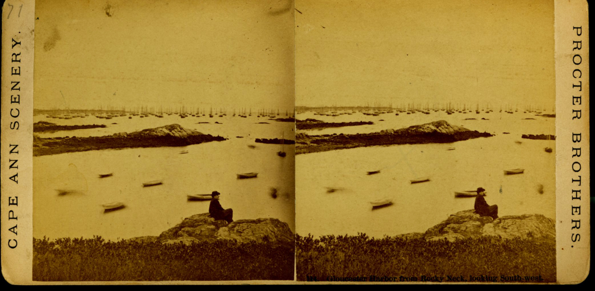
"Gloucester Harbor from Rocky Neck, Looking Southwest. This gives a portion of the Harbor lying between Ten Pound Island and Eastern Point. At the time of taking this picture the wind was from the northeast, and a large fleet of fishing and other vessels were in the harbor. In the range of the picture about one hundred vessels were at anchor. In the small Cove in the foreground quite a number of dories are moored. Eastern Point appears on the left in the background."
Southeast Harbor was known for being a safe harbor.
Also filed under: Gloucester Harbor, Outer » // Historic Photographs » // Rocky Neck » // Schooner (Fishing) »
Also filed under: Chebacco Boat / Dogbody / Pinky » // Ship Models »
Gloucester, MA
4 x 33 1/2 x 7 1/4 in (10.16 x 85.09 x 18.415 cm)
Peabody Essex Museum
Also filed under: Objects » // Ship Models »
Commentary
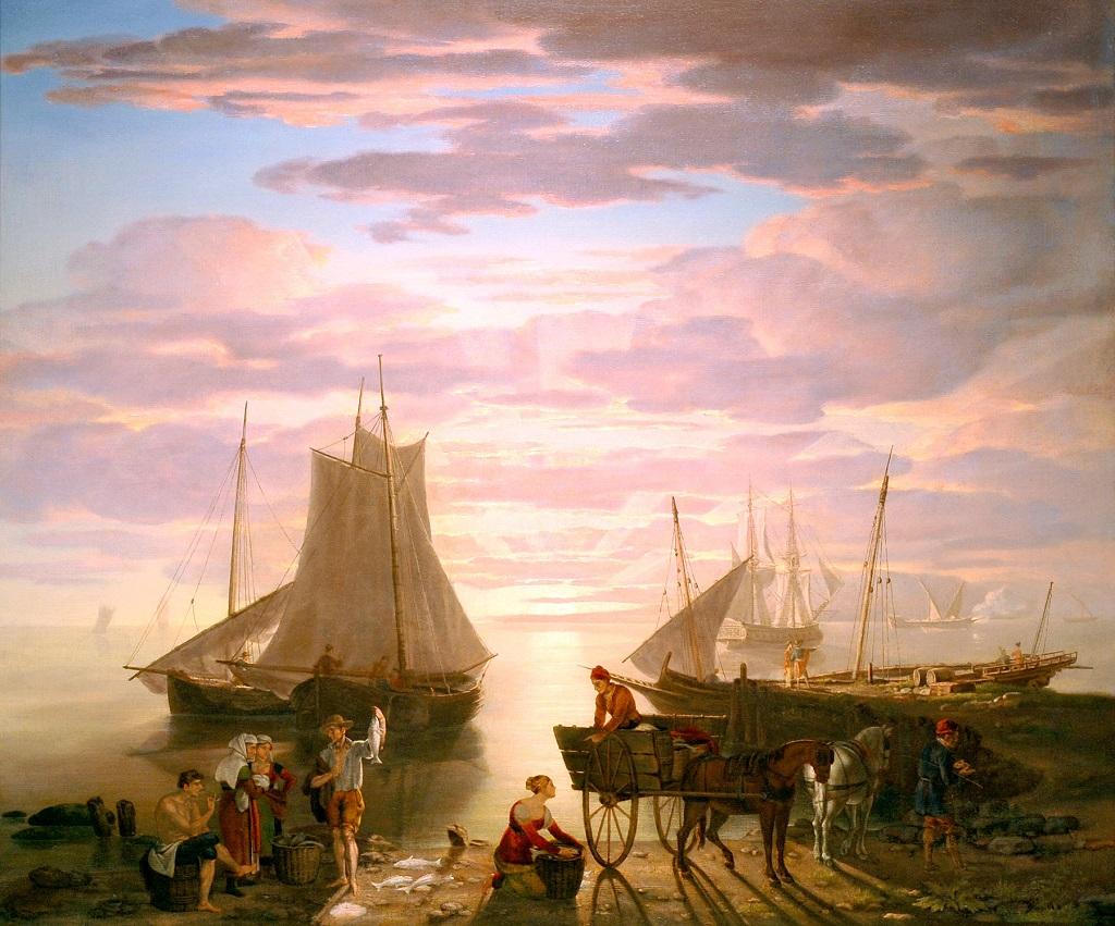
It is unlikely that this port scene depicts Gloucester Harbor for two important reasons: (1) No wharf in Gloucester had the shoreline setting and wharf construction in the combination shown, and (2) The sun does not rise over the harbor’s entrance, which opens to the south-southwest. Some have argued that Lane “altered” rising and setting suns’ positions to some extent in some port scenes, but it is doubtful that Lane and his clients would have tolerated such an extreme liberty with Gloucester Harbor.
Assuming Lane had a specific locale in mind, a more likely setting for this painting would have been an east-facing New England harbor, such as Portsmouth, New Hampshire or Portland, Maine, both of which Lane visited and which were large and deep enough to accommodate the large packet ship (at anchor, drying sail) at left. That vessel alone argues sufficiently for a larger, deeper harbor, and both Portland and Portsmouth had busy urban centers with rural surroundings along adjacent shore lines, as depicted here.
On the beach is a dory of the type used in the New England shore fisheries. Lane’s customary attention to hull form and detail (in this case the run of the hull planking) brings out the elegant geometry of this workaday boat. At right, a cart with a barrel (fish bait?) on board is drawn by a horse so accustomed to the route, the driver can follow. The wharf is an interesting combination of spile and stone block construction, the latter too neatly fashioned to be mistaken for a cob wharf. At its far side, a small sloop is tied up, its sails hanging to dry.
Surrounding the packet ship are a sloop and two schooners, all likely to be in the coastal packet trades. At far right is a merchant brig at anchor, drying sail, and a half brig crossing her bow. Other vessels, and possibly a light house, are in the distance, obscured by mist, much like the artist’s reason for painting this scene.
—Erik Ronnberg
[+] See More