An online project under the direction of the CAPE ANN MUSEUM
Catalogue Entry
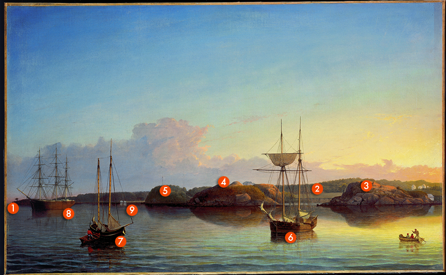
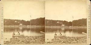
Stage Rocks and Western Shore of Gloucester Outer Harbor is remarkable in several ways. It is in pristine condition and may be as close as any known Lane to showing what the original color and surface were when coming off Lane’s easel. This may also be the painting described by Lane in a letter to Joseph Stevens, one of only several examples we have of Lane discussing his work:
I yesterday made a sketch of Stage Fort and the surrounding scenery from the water. Piper has given me an order for a picture from this point of view to be treated as a sunset. I shall try to make something out of it but it will take some management as there is no foreground but water and vessels.
Lane clearly “managed” the composition of water and vessels masterfully and also created a remarkable study of the effects of light and reflection in transition across a broad spectrum of surfaces. The painting, now in the National Gallery in Washington, D.C. was owned for many years by American art scholar John Wilmerding. The following is his description of the painting excerpted from an essay written in 1967.
The design is carefully structured on the zig-zag line that visually connects the four boats; in pairs their axes are at complementary right angles to each other. In echo the projecting rock masses along the shore behind seem to alternate rhythmically with small, recessed coves. Although most of the surface of the painting is divided into several horizontal zones and punctuated by the vertical interruptions of the ship’s masts, there is a total feeling of swelling and contracting lines of movement as the eye reads laterally across the composition. This is most clear in the rise and fall of the clouds, the outlines of the rocks at shore’s edge, the reverse curves of their reflection in the water, and the placement of the four hulls across the canvas. Yet interest is always directed towards the center, and the overall coherence maintained, by devises [sic] like the oar and arms of the sculling figure in the lower right pointing inward, by cutting off the view down the shoreline at the left with the broadside of the three-master, and by placing the largest elements such as the brightened cloud and tall-masted schooner in the central area itself. Still, cogency of design was not Lane’s only achievement; his understanding and mastery of the uses of color to bring out the effects of light contribute to the enlivenment of the whole painting. His breakdown of shadows into their color components and his application of small touches of pure paint to allow optical mixing of colors are in remarkable, because independent, anticipation of many Impressionist methods developed in the next decades in France. There is a wide range of differentiation in textures throughout the picture, from the clear glazes in the sky and clouds to the softer effects of rocks, trees, or wooden hulls, to the partially rippled, partially calm water surface and it’s [sic] changing reflections. Analysis of the reds and blues alone in this work would reveal the rich but understated variety of Lane’s coloristic touch. There is a remarkable range of reds, for example, in the bright-shirted figures in the boats in each foreground corner and their subtle counterparts reflected beneath, through the more diluted gradations in the clouds, hilltops, and rock reflections, to the lighter oranges at the right or the deeper purple grays at the left. A similar range of values exists in the transitions of blue through the sky and water, where greens emerge, and through the rocks or shadows, where grays and browns are mixed in. Though Lane’s handling is tight and restrained, his full variety and sureness of touch give his work a sparkling freshness seldom seen in his contemporaries. He has achieved an unusual combination of accurate recording and a more lasting aesthetic interest.
– John Wilmerding, reprinted from Essex Institute Historical Collections, January 1967.
 Document
: view »
Historical Materials
Letter
Cape Ann Museum Library & Archive, Gloucester, Mass.
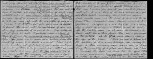
". . . will fully appreciate all that I have done in my garden, in ornamenting it, with flowers and plants, Rustic Arbours and Statues, and I only wish that you could be here to witness and enjoy his [Dr. J. L. Stevens] expressions of delight and interest, when a new flower attracts his attention, or some beauty of arrangement meets his eye. Samuel [B. Stevens of Castine] he tells me came up with the expectation of going on a voyage to Australia, but when he arrived in Boston he found the vessel with her compliment of men, and it is very uncertain if he goes in her. Your Mother and all at home are well. I yesterday made a sketch of Stage Fort and the surrounding scenery, from the water. Piper has given me an order for a picture from this point of view, to be treated as a sunset. I shall try to make something out of it, but it will require some management, as there is no foreground but water and vessels. One o’clock, it is very hot, the glass indicates 84° in my room, with the windows all open and a light breeze from the east, this is the warmest day . . .
. . . than devoting it to you. Since writing you last I have painted but one picture worth talking about and that one I intend for you if you should be pleased with it. It is a View of the beach between Stage Fort and Steep bank including Hovey’s Hill and residence, Fresh water cove and the point of land with the lone pine tree. Fessenden’s house, likewise comes into the picture. The effect is a mid day light with a cloudy sky, a patch of sunlight is thrown across the beach and the breaking waves, an old vessel lies stranded on the beach with two or three figures, there are a few vessels in the distance and the Field rocks likewise show at the left of the picture. I think you will be pleased with this picture, for it is a very picturesque scene especially the beach, as there are many rocks which come in to destroy the monotony of a plain sand beach, and I have so arranged the light and shade that the effect I think is very good indeed, however you will be better able to judge of that when you see it, the size is 20 x 33. . ."
Steepbank (sometimes spelled "Steep Bank") was a house near Fresh Water Cove which, in Lane's time, served as a summer estate for brothers, Eben and Theron Dale. It had been built for “an artist” named “Mr. Eddy” in 1845, was next owned by a “Mr. Homer,” and then by a “Mr. C. B. Fessenden." Around 1858 it was purchased by Eben Dale.
Commonwealth of Massachusetts: Southern Essex District Registry of Deeds
1543 plan 0141_0002
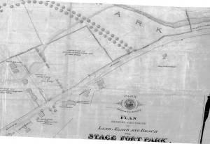
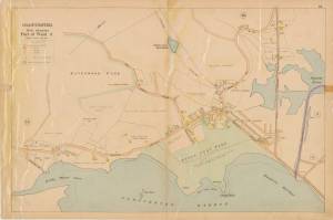
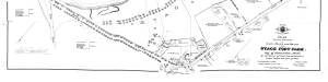
The third of the three plans has the references on it. "Plan showing the taking of land, flats and beach for Stage Fort Park…1898..."
Includes a reference to the home of Mary Turnbull which is Steepbank.
Also filed under: Maps » // Stage Rocks / Stage Fort / Stage Head »
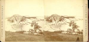
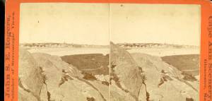
c.1870 Stereograph card Cape Ann Museum Library & Archive
Also filed under: Gloucester – City Views » // Half Moon Beach » // Historic Photographs » // Stage Rocks / Stage Fort / Stage Head »
Newsprint
From bound volume owned by publisher Francis Procter
Collection of Fred and Stephanie Buck
"We visited the studio of Mr. Fitz H. Lane a few days since, and were much pleased in examining some fine paintings from the pencil of this talented artist. Among the collection was a view of Long Beach, in this town, with which we were particularly interested.
The scene is taken immediately after a storm. The waves with their snowy crests are rolling in upon the beach, breaking against the sides of a vessel which has been driven ashore. In the background is seen the residence of Mr. Fessenden, and the surrounding scenery; on the right are visible the high headlands near the residence of Mr. Geo. Hovey, while stretching far away in the distance may be seen Fresh Water Cove, Dolliver's Neck, and the Old Pine Tree, the whole forming a beautiful picture and true to Nature.
Several other paintings were in process of completion, one a beautiful sunset scene, which was really beautiful to gaze upon; also a view of a gale at sea, with a gallant ship plunging madly through the waves, forming a striking contrast to the mild placid scene of the picture at its side.
Mr. Lane's paintings are true to nature, and in viewing them one can but admire the skill and genius of this talented artist, We advise all lovers of the art, who wish to spend an hour pleasantly, to visit the studio of Mr. Lane on Locust St. We can assure them that they will come away highly gratified, and have an earnest desire to call again." (1)
(1) See p. 2, column 3, Courtesy of the American Antiquarian Society
Also filed under: Chronology » // Dolliver's Neck » // Fessenden, C. B. » // Fresh Water Cove » // Lone Pine » // Newspaper / Journal Articles » // Studio Descriptions »

44 x 34 in.
Henry Francis Walling, Map of the Towns of Gloucester and Rockport, Essex Co. Massachusetts. Philadelphia, A. Kollner, 1851
Cape Ann Museum Library & Archive
"Map of the Towns of Gloucester and Rockport, Massachusetts. H.F. Walling, Civil Engineer. John Hanson, Publisher. 1851. Population of Gloucester in 1850: 7,805. Population of Rockport in 1850: 3,213."
Also filed under: Annisquam River » // Brookbank » // Dolliver's Neck » // Fresh Water Cove » // Gloucester Harbor, Outer » // Maps » // Norman's Woe » // Stage Rocks / Stage Fort / Stage Head » // West Gloucester – Little River » // Western Shore »
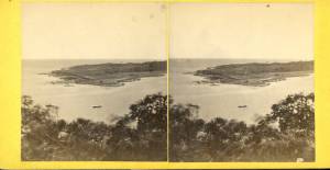
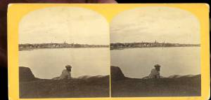
c.1860 Stereograph card Cape Ann Museum Library & Archive
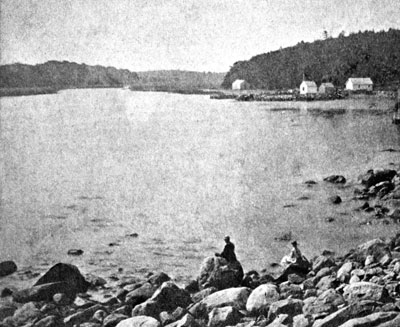
Taken from Steepbank, on the western side of Gloucester Harbor, and showing a small boat at anchor in the cove, then the Neck, and the sea beyond.
Also filed under: Dolliver's Neck » // Fresh Water Cove » // Historic Photographs » // Lone Pine »
Letter
Cape Ann Museum Library & Archive, Gloucester, Mass.
". . . will fully appreciate all that I have done in my garden, in ornamenting it, with flowers and plants, Rustic Arbours and Statues, and I only wish that you could be here to witness and enjoy his [Dr. J. L. Stevens] expressions of delight and interest, when a new flower attracts his attention, or some beauty of arrangement meets his eye. Samuel [B. Stevens of Castine] he tells me came up with the expectation of going on a voyage to Australia, but when he arrived in Boston he found the vessel with her compliment of men, and it is very uncertain if he goes in her. Your Mother and all at home are well. I yesterday made a sketch of Stage Fort and the surrounding scenery, from the water. Piper has given me an order for a picture from this point of view, to be treated as a sunset. I shall try to make something out of it, but it will require some management, as there is no foreground but water and vessels. One o’clock, it is very hot, the glass indicates 84° in my room, with the windows all open and a light breeze from the east, this is the warmest day . . .
. . . than devoting it to you. Since writing you last I have painted but one picture worth talking about and that one I intend for you if you should be pleased with it. It is a View of the beach between Stage Fort and Steep bank including Hovey’s Hill and residence, Fresh water cove and the point of land with the lone pine tree. Fessenden’s house, likewise comes into the picture. The effect is a mid day light with a cloudy sky, a patch of sunlight is thrown across the beach and the breaking waves, an old vessel lies stranded on the beach with two or three figures, there are a few vessels in the distance and the Field rocks likewise show at the left of the picture. I think you will be pleased with this picture, for it is a very picturesque scene especially the beach, as there are many rocks which come in to destroy the monotony of a plain sand beach, and I have so arranged the light and shade that the effect I think is very good indeed, however you will be better able to judge of that when you see it, the size is 20 x 33. . ."
Commonwealth of Massachusetts: Southern Essex District Registry of Deeds
1543 plan 0141_0001
The third of the three plans has the references on it “Plan showing the taking of land, flats and beach for Stage Fort Park…1898…”
Includes a reference to the home of Mary Turnbull which is Steepbank.
Also filed under: Field Beach / Crescent (or Cressy's) Beach / Long Beach » // Maps » // Stage Rocks / Stage Fort / Stage Head »
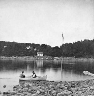
The owner of this flagpole has not been determined, but it is an interesting landmark in Lane's paintings. Often it appears in his drawings and not in his paintings, and Western Shore of Gloucester Outer Harbor, 1857 (inv. 107) contains the only image of a flag actually flying from the pole.
Fresh Water Cove is located on the west side of Gloucester’s Outer Harbor. It is protected from the harbor waters and the south-easterly seas by the arm of Dolliver’s Neck reaching north from the western shore. It’s a small, very still cove, only a few hundred yards from its mouth to the innermost shore.
The cove was visited by Samuel de Champlain in 1606. He was the first known European to enter Gloucester Harbor, which he named Le Beauport. He named Fresh Water Cove for the fresh water springs he found there, one a bit up from the shore, the other flowing below the high tide line and only accessible at half tide.
The cove, while very well protected from the weather, is small and very shallow at low tide and was never suitable for any large vessels, though there were fishing shacks along the shores edge and small boats were easily pulled up on the sand and salt marsh in its inner recesses. There was a wharf built in the early 1800s to service a granite quarry just up the hill from the cove, which could apparently handle larger vessels at high tide.
In Lane’s time, the most significant landmark from the cove was Brookbank, the Sawyer homestead where Samuel E. Sawyer was born in 1818. Sawyer made a fortune in Boston and returned to Brookbank every summer for fifty years. He became one of Gloucester’s first philanthropists. Lane did a series of paintings from the fields in front of Brookbank looking to the east from the house over Fresh Water Cove, the arm of Dolliver’s Neck and the harbor beyond. He also painted the opposite view in Fresh Water Cove from Dolliver's Neck, Gloucester, Early 1850s (inv. 45) looking west from Dolliver’s Neck over the cove to the Sawyer homestead and surrounding shoreline. Each of these paintings captures the perfect serenity of a high summer day in this secluded cove just off the busy harbor.
Stereograph card
Cape Ann Museum Library & Archive
Also filed under: Brookbank »
44 x 34 in.
Henry Francis Walling, Map of the Towns of Gloucester and Rockport, Essex Co. Massachusetts. Philadelphia, A. Kollner, 1851
Cape Ann Museum Library & Archive
"Map of the Towns of Gloucester and Rockport, Massachusetts. H.F. Walling, Civil Engineer. John Hanson, Publisher. 1851. Population of Gloucester in 1850: 7,805. Population of Rockport in 1850: 3,213."
Also filed under: Annisquam River » // Brookbank » // Dolliver's Neck » // Gloucester Harbor, Outer » // Maps » // Norman's Woe » // Stage Rocks / Stage Fort / Stage Head » // Steepbank » // West Gloucester – Little River » // Western Shore »
c.1860 Stereograph card Cape Ann Museum Library & Archive
Taken from Steepbank, on the western side of Gloucester Harbor, and showing a small boat at anchor in the cove, then the Neck, and the sea beyond.
Also filed under: Dolliver's Neck » // Historic Photographs » // Lone Pine » // Steepbank »
Newspaper
"Mr. Lane has just completed a third picture of the Western Shore of Gloucester Harbor, including the distance from 'Norman's Woe Rock' to 'Half Moon Beach.' It was painted for Mr. William E. Coffin of Boston, and will be on exhibition at the artist's rooms for only a few days; we advise all our readers who admire works of art, and would see one of the best pictures Mr. Lane has ever executed..."
"...solitary pine, so many years a familiar object and landmark to the fisherman."

Newsprint
From bound volume owned by publisher Francis Procter
Collection of Fred and Stephanie Buck
"We visited the studio of Mr. Fitz H. Lane a few days since, and were much pleased in examining some fine paintings from the pencil of this talented artist. Among the collection was a view of Long Beach, in this town, with which we were particularly interested.
The scene is taken immediately after a storm. The waves with their snowy crests are rolling in upon the beach, breaking against the sides of a vessel which has been driven ashore. In the background is seen the residence of Mr. Fessenden, and the surrounding scenery; on the right are visible the high headlands near the residence of Mr. Geo. Hovey, while stretching far away in the distance may be seen Fresh Water Cove, Dolliver's Neck, and the Old Pine Tree, the whole forming a beautiful picture and true to Nature.
Several other paintings were in process of completion, one a beautiful sunset scene, which was really beautiful to gaze upon; also a view of a gale at sea, with a gallant ship plunging madly through the waves, forming a striking contrast to the mild placid scene of the picture at its side.
Mr. Lane's paintings are true to nature, and in viewing them one can but admire the skill and genius of this talented artist, We advise all lovers of the art, who wish to spend an hour pleasantly, to visit the studio of Mr. Lane on Locust St. We can assure them that they will come away highly gratified, and have an earnest desire to call again." (1)
(1) See p. 2, column 3, Courtesy of the American Antiquarian Society
Also filed under: Chronology » // Dolliver's Neck » // Fessenden, C. B. » // Lone Pine » // Newspaper / Journal Articles » // Steepbank » // Studio Descriptions »
1860s Stereograph card Cape Ann Museum Library & Archive
A view of a Cove on the western side of Gloucester Harbor, with the landing at Brookbank. Houses are seen in the woods back. A boat with two men is in the foreground.
Also filed under: American ensign / flag » // Brookbank » // Historic Photographs »
4 x 5 in.
Cape Ann Museum Library & Archive
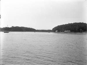
Freshwater Cove and Dolliver's Neck from the water off Stage Fort.
Also filed under: Dolliver's Neck »
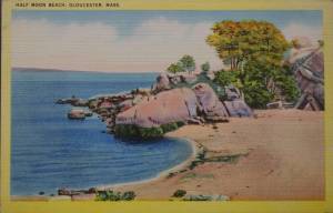
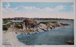
Half Moon Beach is a small crescent of sand, nestled into Stage Fort Park, between Stage Point (where the remains of a Revolutionary War earthworks fort still stands) and a large ledge outcropping that on the far side houses the tablet commemorating the original 1623 settlement of the area by the Dorchester Company. At the time Lane painted his views of the Harbor in which one can see this beach, the entire little peninsula, once known as Fisherman's Field, was probably owned by the B. K. Hough family. The area, including this beach, is now public. From the beach, one can see much of the Outer Harbor, Pavilion Beach, and Ten Pound Island.
– Sarah Dunlap (June, 2015)
c.1870 Stereograph card Cape Ann Museum Library & Archive
Also filed under: Historic Photographs » // Stage Rocks / Stage Fort / Stage Head » // Western Shore »
c.1870 Stereograph card Cape Ann Museum Library & Archive
Also filed under: Historic Photographs »
Newspaper
"Mr. Lane has just completed a third picture of the Western Shore of Gloucester Harbor, including the distance from 'Norman's Woe Rock' to 'Half Moon Beach.' It was painted for Mr. William E. Coffin of Boston, and will be on exhibition at the artist's rooms for only a few days; we advise all our readers who admire works of art, and would see one of the best pictures Mr. Lane has ever executed..."
"...solitary pine, so many years a familiar object and landmark to the fisherman."
c.1870 Stereograph card Cape Ann Museum Library & Archive
Also filed under: Gloucester – City Views » // Historic Photographs » // Stage Rocks / Stage Fort / Stage Head » // Steepbank »
29 x 25 in.
Cape Ann Museum Library & Archive (#089)
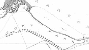
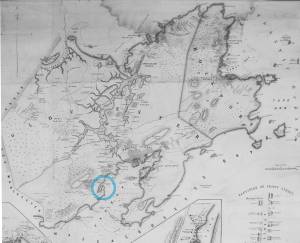
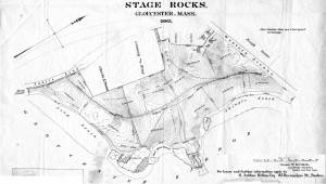
Ernest Bowditch was a landscape gardener. This map shows some of the various names of landmarks around Stage Rocks.
Also filed under: Field Beach / Crescent (or Cressy's) Beach / Long Beach » // Maps » // Stage Rocks / Stage Fort / Stage Head »
Although the exact location and information about the "Lone Pine" or "Old Pine Tree" is unknown, it was a well-recognized landmark in Lane's day. It was situated on the very tip of Dolliver's Neck, and as a result of its height and location near the shoreline, was seen easily from many points, especially across the water. The tree is clearly visible in Dolliver's Neck and the Western Shore from Field Beach, 1857 (inv. 3).
Newsprint
From bound volume owned by publisher Francis Procter
Collection of Fred and Stephanie Buck
"We visited the studio of Mr. Fitz H. Lane a few days since, and were much pleased in examining some fine paintings from the pencil of this talented artist. Among the collection was a view of Long Beach, in this town, with which we were particularly interested.
The scene is taken immediately after a storm. The waves with their snowy crests are rolling in upon the beach, breaking against the sides of a vessel which has been driven ashore. In the background is seen the residence of Mr. Fessenden, and the surrounding scenery; on the right are visible the high headlands near the residence of Mr. Geo. Hovey, while stretching far away in the distance may be seen Fresh Water Cove, Dolliver's Neck, and the Old Pine Tree, the whole forming a beautiful picture and true to Nature.
Several other paintings were in process of completion, one a beautiful sunset scene, which was really beautiful to gaze upon; also a view of a gale at sea, with a gallant ship plunging madly through the waves, forming a striking contrast to the mild placid scene of the picture at its side.
Mr. Lane's paintings are true to nature, and in viewing them one can but admire the skill and genius of this talented artist, We advise all lovers of the art, who wish to spend an hour pleasantly, to visit the studio of Mr. Lane on Locust St. We can assure them that they will come away highly gratified, and have an earnest desire to call again." (1)
(1) See p. 2, column 3, Courtesy of the American Antiquarian Society
Also filed under: Chronology » // Dolliver's Neck » // Fessenden, C. B. » // Fresh Water Cove » // Newspaper / Journal Articles » // Steepbank » // Studio Descriptions »
Newspaper
"Mr. Lane has just completed a third picture of the Western Shore of Gloucester Harbor, including the distance from 'Norman's Woe Rock' to 'Half Moon Beach.' It was painted for Mr. William E. Coffin of Boston, and will be on exhibition at the artist's rooms for only a few days; we advise all our readers who admire works of art, and would see one of the best pictures Mr. Lane has ever executed..."
"...solitary pine, so many years a familiar object and landmark to the fisherman."
c.1860 Stereograph card Cape Ann Museum Library & Archive
Taken from Steepbank, on the western side of Gloucester Harbor, and showing a small boat at anchor in the cove, then the Neck, and the sea beyond.
Also filed under: Dolliver's Neck » // Fresh Water Cove » // Historic Photographs » // Steepbank »
Letter
Cape Ann Museum Library & Archive, Gloucester, Mass.
". . . will fully appreciate all that I have done in my garden, in ornamenting it, with flowers and plants, Rustic Arbours and Statues, and I only wish that you could be here to witness and enjoy his [Dr. J. L. Stevens] expressions of delight and interest, when a new flower attracts his attention, or some beauty of arrangement meets his eye. Samuel [B. Stevens of Castine] he tells me came up with the expectation of going on a voyage to Australia, but when he arrived in Boston he found the vessel with her compliment of men, and it is very uncertain if he goes in her. Your Mother and all at home are well. I yesterday made a sketch of Stage Fort and the surrounding scenery, from the water. Piper has given me an order for a picture from this point of view, to be treated as a sunset. I shall try to make something out of it, but it will require some management, as there is no foreground but water and vessels. One o’clock, it is very hot, the glass indicates 84° in my room, with the windows all open and a light breeze from the east, this is the warmest day . . .
. . . than devoting it to you. Since writing you last I have painted but one picture worth talking about and that one I intend for you if you should be pleased with it. It is a View of the beach between Stage Fort and Steep bank including Hovey’s Hill and residence, Fresh water cove and the point of land with the lone pine tree. Fessenden’s house, likewise comes into the picture. The effect is a mid day light with a cloudy sky, a patch of sunlight is thrown across the beach and the breaking waves, an old vessel lies stranded on the beach with two or three figures, there are a few vessels in the distance and the Field rocks likewise show at the left of the picture. I think you will be pleased with this picture, for it is a very picturesque scene especially the beach, as there are many rocks which come in to destroy the monotony of a plain sand beach, and I have so arranged the light and shade that the effect I think is very good indeed, however you will be better able to judge of that when you see it, the size is 20 x 33. . ."
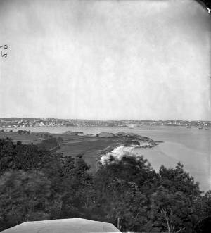
The Stage, as it was known in Lane’s time, now Stage Fort Park, rises from the western shore of the Outer Harbor, just south and west of the Cut and the Blynman Bridge as you leave Gloucester. This was the first settlement of the Massachusetts Bay Colony in 1623 where fourteen men of the Dorchester Company landed and tried in vain to settle and survive through a combination of fishing and farming. They were successful at neither, and in 1626 they moved on and founded Salem.
During the Revolution the Gloucester patriots built a fort on the north side of Half Moon Beach to defend against British invaders which was never needed. The fort was restored for the War of 1812 and again for the Civil War, but again saw no action.
During Lane’s lifetime this area was the Hough farm. Townspeople were generally given free run of the place for strolling and picnics overlooking the harbor. The enormous rounded boulders and ledge outcroppings rose dramatically from the fields above the harbor without the tree cover that partially obscures them today.
Lane did numerous paintings of this area, including many views looking westward from the vantage point onboard a boat in the harbor. In Stage Rocks and the Western Shore of Gloucester Outer Harbor, 1857 (inv. 8) the Stage Rocks frame the west side of Gloucester Harbor and provided a peaceful and bucolic counterpoint to the intense activity of the city waterfront only a mile away across the harbor. Lane also painted the Stage Rocks from the beach just to the north near the Cut and Field Beach, which is on the southern side of the Stage Rocks facing out the harbor entrance to the sea.
Commonwealth of Massachusetts: Southern Essex District Registry of Deeds
1543 plan 0141_0002
The third of the three plans has the references on it. "Plan showing the taking of land, flats and beach for Stage Fort Park…1898..."
Includes a reference to the home of Mary Turnbull which is Steepbank.
Also filed under: Maps » // Steepbank »
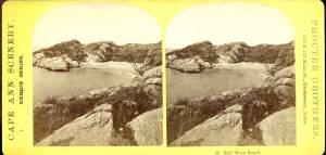
c.1870 Stereograph card Cape Ann Museum Library & Archive
Also filed under: Gloucester – City Views » // Half Moon Beach » // Historic Photographs » // Steepbank »
44 x 34 in.
Henry Francis Walling, Map of the Towns of Gloucester and Rockport, Essex Co. Massachusetts. Philadelphia, A. Kollner, 1851
Cape Ann Museum Library & Archive
"Map of the Towns of Gloucester and Rockport, Massachusetts. H.F. Walling, Civil Engineer. John Hanson, Publisher. 1851. Population of Gloucester in 1850: 7,805. Population of Rockport in 1850: 3,213."
Also filed under: Annisquam River » // Brookbank » // Dolliver's Neck » // Fresh Water Cove » // Gloucester Harbor, Outer » // Maps » // Norman's Woe » // Steepbank » // West Gloucester – Little River » // Western Shore »
c.1870 Stereograph card Cape Ann Museum Library & Archive
Also filed under: Half Moon Beach » // Historic Photographs » // Western Shore »
c.1870 Stereograph card Cape Ann Museum Library & Archive
Also filed under: Gloucester – City Views » // Historic Photographs »
c.1890 Stereograph card Cape Ann Museum Library & Archive
"In the foreground is a clear sheet of water which washes upon the beach beyond. The Pavilion is quite prominent, while upon the rising background can be seen the steeples of the several churchs, the tower of the first Town House, and the Collins School House."
Also filed under: Gloucester – City Views » // Historic Photographs » // Pavilion Hotel »
Cape Ann Museum Library & Archive
Stage Fort from Hough's Farm, showing a panorama of the harbor from Pavilion Beach to Fort Point and Rocky Neck.
Also filed under: Field Beach / Crescent (or Cressy's) Beach / Long Beach »

c.1870 Stereograph card Procter Brothers, Publisher Cape Ann Museum Library & Archive
Also filed under: Gloucester Harbor, Outer » // Historic Photographs »
Commonwealth of Massachusetts. Southern Essex District Registry of Deeds. 1543 plan 0141_0003
salemdeeds.com
The third of the three plans has the references on it “Plan showing the taking of land, flats and beach for Stage Fort Park…1898…"
Includes a reference to the home of “Mary Turnbull” which is Steepbank.
Also filed under: Maps »
Commonwealth of Massachusetts: Southern Essex District Registry of Deeds
1543 plan 0141_0001
The third of the three plans has the references on it “Plan showing the taking of land, flats and beach for Stage Fort Park…1898…”
Includes a reference to the home of Mary Turnbull which is Steepbank.
Also filed under: Field Beach / Crescent (or Cressy's) Beach / Long Beach » // Maps » // Steepbank »
Colored lithograph
Cape Ann Museum Library and Archive
Also filed under: Western Shore »
29 x 25 in.
Cape Ann Museum Library & Archive (#089)
Ernest Bowditch was a landscape gardener. This map shows some of the various names of landmarks around Stage Rocks.
Also filed under: Field Beach / Crescent (or Cressy's) Beach / Long Beach » // Half Moon Beach » // Maps »
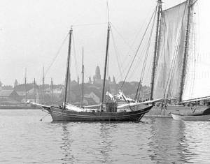
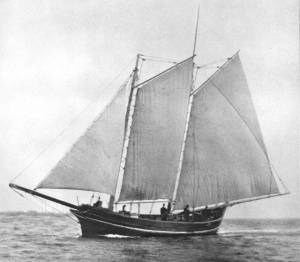
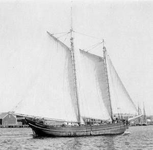
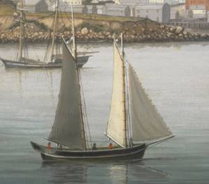
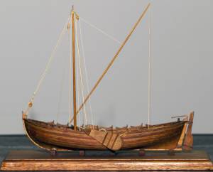
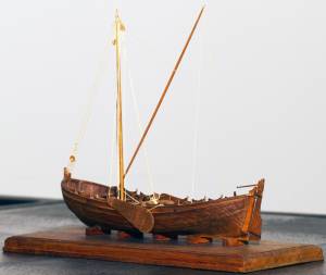
The colonial American shallop is the ancestor of many regional types of New England fishing craft found in Lane's paintings and drawings, including "New England Boats" (known as "boats" and discussed elsewhere), and later descendents, such as "Chebacco Boats," "Dogbodies," and "Pinkies."
These boats were very common work boat types on Cape Ann throughout the 1800s. They were primarily used for inshore coastal fishing, which included lobstering, gill-netting, fish-trapping, hand-lining, and the like. They were usually sailed by one or two men, sometimes with a boy, and could be rowed as well as sailed. An ordinary catch would include rock cod, flounder, fluke, dabs, or other small flat fish. The catch would be eaten fresh, or salted and stored for later consumption, or used as bait fish. Gill-netting would catch herring and alewives when spawning. Wooden lobster traps were marked with buoys much as they are today, and hauled over the low sides of the boat, emptied of lobsters and any by-catch, re-baited and thrown back.
CHEBACCO BOATS AND PINKIES
In the Chebacco Parish of the Ipswich Colony, a larger version of the colonial shallop evolved to a heavily built two-masted boat with either a sharp or square stern. This development included partial decking at bow and stern, the former as a cuddy which was fitted with crude bunks and a brick fireplace for cooking. Further development provided midship decking over a fish hold with standing rooms fore and aft for fishing. At this stage, low bulwarks replaced simple rails and in the double-enders were extended aft beyond the rudderhead to form a “pinched,” or “pink“ stern. Some time in the second half of the eighteenth century, boats with these characteristics became known as Chebacco Boats. The squarestern versions were called Dogbodies, for reasons now forgotten. (1)
Chebacco Boats became the vessels of choice for Cape Ann fishermen working coastal grounds for cod, mackerel, herring, and groundfish with hook and line or with nets. This did not prevent them from venturing further, particularly in pursuit of migrating schools of mackerel. The “Bashalore,” a corruption of the Bay of Chaleur in the Gulf of St. Lawrence, was a favorite destination for Cape Ann Fishermen who fished for mackerel in that region. (2)
Lane undoubtedly saw Chebacco Boats in the years prior to his move to Boston, but if he made drawings or paintings of them in that period, none have come to light. A small lithograph, titled “View of the Old Fort and Harbor 1837,” is attributed to him, but the vessels and wharf buildings are too crudely drawn to warrant this undocumented claim. (3) Lane did see and render accurately the Chebacco Boat’s successor the Pinky—which was larger and had a schooner rig (two masts, main sail, fore sail, jib, and main topmast staysail).
Schooners with pinksterns were recorded early in the 18th century later that there were models and graphic representations of hull form and rig (Ref. 4). By then, the pinky was very similar in hull form to Chebacco Boats, and some Chebacco Boats were converted to pinkies by giving them schooner rigs. A pinky in Lane’s The Old Fort and Ten Pound Island, Gloucester, 1850s (inv. 30) (misdated 1850s, more likely mid-1840s) is quite possibly an example of such a conversion.
Lane’s depictions of pinkies in Massachusetts waters are numerous and sometimes very informative. Examples in his views of Gloucester Harbor portray them at various angles, from broadside (see Gloucester Harbor from Rocky Neck, 1844 (inv. 14), The Old Fort and Ten Pound Island, Gloucester, 1850s (inv. 30), and View of the Town of Gloucester, Mass., 1836 (inv. 86)) to stern (see The Western Shore with Norman's Woe, 1862 (inv. 18), The Old Fort and Ten Pound Island, Gloucester, 1850s (inv. 30), and Gloucester Harbor, 1850s (inv. 391)), but few, if any, bow views. His portrayals of pinkies in Boston Harbor and vicinity are more in the foreground and more generous in detail. The earliest of these, from 1845, shows a pinky getting underway in a hurry as the yacht "Northern Light" bears down on her in The Yacht "Northern Light" in Boston Harbor, 1845 (inv. 268). A late harbor view (id ) offers a rare bow view.
Like the Chebacco Boat, the pinky was primarily a fishing vessel, doing much the same kind of fishing in coastal waters, but large enough to venture further offshore to work on the banks in the Gulf of Maine in pursuit of the cod. By the 1820s, pinkies reached their largest size: 50 to 60 feet on deck. Beyond that size called for a different deck arrangement and higher rails, so men could stand on deck and fish from the rails – an arrangement offered by the banks fishing schooner. (5)
What is perhaps Lane’s most detailed and narrative view of a pinky appears in Becalmed Off Halfway Rock, 1860 (inv. 344) and dominates the right foreground. Fitted-out for mackerel gillnetting, she has a dory and a wherry in tow, the latter with the net in the stern. The crew is relaxed, enjoying the evening calm as the vessel heads for port. The barrels on deck are filled with freshly caught mackerel, which will be sold as such when landed, most likely at Gloucester. This pinky was probably fishing on Stellwagen Bank or Cape Cod Bay, which were good fishing grounds for mackerel, and close enough to Gloucester to make trips in smaller vessels worthwhile. To judge from his paintings, Lane found only a few pinkies in the parts of the Maine Coast he explored. Only one drawing (Southwest Harbor, Mount Desert, 1852 (inv. 184)) and two widely published paintings (Entrance of Somes Sound, Mount Desert, Maine, 1855 (inv. 347) and Bar Island and Mt. Desert Mountains from Somes Settlement, 1850 (inv. 401)) illustrate this type, and then at a distance. What is apparent is that pinkies in southern Maine did not differ markedly from those on the Massachusetts coast. Had Lane ventured further Down East, he might have found modifications to the type that reflected Canadian influences. (6)
– Erik Ronnberg
References:
1. William A. Baker, Sloops & Shallops (Barre, MA: Barre Publishing Co., 1966), 82–91; and Howard I. Chapelle, The American Fishing Schooners, 1825–1935 (New York: W.W. Norton & Co., 1973), 25–27.
2. G. Brown Goode, The Fisheries and Fishery Industries of the United States, Section V, Vol. I (Washington, DC: Government Printing Office, 1884–87), 275, 287, 298–300, 419–21, 425–32, 459–63.
3. John J. Babson, History of the Town of Gloucester, Cape Ann (Procter Bros., 1860, reprint: Gloucester, MA: Peter Smith, 1972), see lithograph facing p. 474.
4. Goode, 275–77, 280, 294–96.
5. Chapelle, 36–37.
6. Ibid., 45–54.
Glass plate negative
3 x 4 in.
Cape Ann Museum Library & Archive
#10112
Also filed under: Gloucester Harbor, Inner / Harbor Cove »
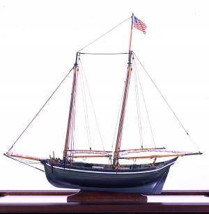
Also filed under: Ship Models »
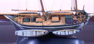
Also filed under: Ship Models »
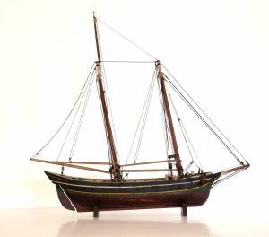
Also filed under: Ship Models » // Small Craft – Wherries, and Dories »
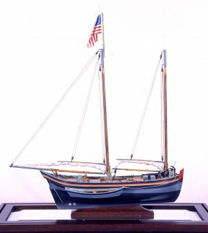
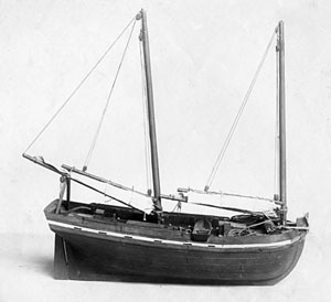
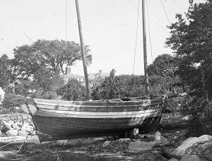
20" l. x 19" h. x 3 3/4" w. [not to scale]
Cape Ann Museum. Gift of Mr. J. Hollis Griffin, 1940 (891)
"Pinkys" were early nineteenth-century schooner-rigged derivations of Chebacco boats. This model is a good example of a traditional “sailor’s model,” or in this case, a sailmaker’s model, Mr. Nickerson having been a sailmaker.
Also filed under: Ship Models »


1860 In John J. Babson, History of the Town Gloucester (Gloucester, MA: Procter Brothers, 1860) Cape Ann Museum Library & Archives, Gloucester, Mass.
See p. 474.
View related catalogue entries (4) »
Also filed under: Babson History of the Town of Gloucester » // Fort (The) and Fort Point » // Gloucester Harbor, Inner / Harbor Cove » // Gloucester, Mass. - "Ten Pound Island Light » // Schooner (Coasting / Lumber / Topsail / Packet / Marsh Hay) » // Ten Pound Island »
The colonial American shallop is the ancestor of many regional types of New England fishing craft found in Lane's paintings and drawings, including "New England Boats" (known as "boats"), and later descendents, such as "Chebacco Boats," "Dogbodies," and "Pinkies." (discussed elsewhere)
These boats were very common work boat types on Cape Ann throughout the 1800s. They were primarily used for inshore coastal fishing, which included lobstering, gill-netting, fish-trapping, hand-lining, and the like. They were usually sailed by one or two men, sometimes with a boy, and could be rowed as well as sailed. An ordinary catch would include rock cod, flounder, fluke, dabs, or other small flat fish. The catch would be eaten fresh, or salted and stored for later consumption, or used as bait fish. Gill-netting would catch herring and alewives when spawning. Wooden lobster traps were marked with buoys much as they are today, and hauled over the low sides of the boat, emptied of lobsters and any by-catch, re-baited and thrown back.
THE SHALLOP
Like other colonial vessel types, shallops were defined in many ways, including size, construction, and rig. Most commonly, they were open boats with square or sharp sterns, 20 to 30 feet in length, two-masted rigs, and heavy sawnframe construction which in time became lighter. (1)
The smaller shallops developed into a type called the Hampton Boat early in the nineteenth century, becoming the earliest named regional variant of what is now collectively termed the New England Boat. Other variants were named for their regions of origin: Isles of Shoals Boat, Casco Bay Boat, No Mans Land Boat, to name a few. No regional name for a Cape Ann version has survived, and "boat," or "two-masted boat" seems to have sufficed. (2)
Gloucester's New England Boats were mostly double-enders (sharp sterns) ranging in length from 25 to 30 feet, with two masts and two sails (no bowsprit or jib). They were used in the shore fisheries: handlining, gillnetting, and gathering or trapping shellfish (see View from Kettle Cove, Manchester-by-the-Sea, 1847 (inv. 94), View of Gloucester Harbor, 1848 (inv. 97), and /entry: 240/). (3)
Larger, double-ended shallops became decked and evolved in Ipswich (the part now called Essex) to become Chebacco Boats. (4) This variant retained the two-mast, two-sail rig, but evolved further, acquiring a bowsprit and jib and becoming known as a pinky (see Gloucester Harbor from Rocky Neck, 1844 (inv. 14), The Western Shore with Norman's Woe, 1862 (inv. 18), and The Old Fort and Ten Pound Island, Gloucester, 1850s (inv. 30)). The Chebacco Boat became a distinct type by the mid-eighteenth century giving rise to the pinky in the early ninetennth century; the latter, by the early 1900s. (5)
References:
1. William A. Baker, Sloops & Shallops (Barre, MA: Barre Publishing Co., 1966), 27–33; and “Vessel Types of Colonial Massachusetts,” in Seafaring in Colonial Massachusetts (Boston: The Colonial Society of Massachusetts, 1980), 13–15, see figs. 10, 11.
2. Howard I. Chapelle, American Small Sailing Craft (New York: W.W. Norton & Co., 1951), 136–45.
3. Ibid., 145, upper photo, fourth page of plates.
4. Baker, 82–91.
5. Chapelle, The American Fishing Schooners, 1825–1935 (New York: W.W. Norton & Co., 1973), 23–54.
THE NEW ENGLAND BOAT
By the 1840s, the Gloucester version of the New England Boat had evolved into a distinct regional type. Referred to locally as “boats,” the most common version was a double-ender, i.e. having a pointed stern, unlike the less common version having a square stern.
Both variants had two masts, a foresail, a mainsail, but no bowsprit or jib. Lane depicted both in several paintings, beginning in the mid-1840s (see View from Kettle Cove, Manchester-by-the-Sea, 1847 (inv. 94), View of Gloucester Harbor, 1848 (inv. 97), and /entry: 240/), all ranging 25 to 30 feet in length. In View of Gloucester Harbor, 1848 (inv. 97) and Gloucester Inner Harbor, 1850 (inv. 240), a double-ender can be seen on the beach while a square-stern version lies at anchor in the harbor, just to the right of the former. (1)
Lane’s depictions of the double-enders show lapstrake hull planking in View of Gloucester Harbor, 1848 (inv. 97) and Gloucester Inner Harbor, 1850 (inv. 240), and cuddies (short decking) inboard at the ends for shelter and stowage of fishing gear in View from Kettle Cove, Manchester-by-the-Sea, 1847 (inv. 94). The few square-stern examples (see View of Gloucester Harbor, 1848 (inv. 97) and Gloucester Inner Harbor, 1850 (inv. 240)) suggest carvel (smooth) planking and paint finish, rather than oil and tar. The presence of an example of the latter variant in Boston Harbor, as noted in Boston Harbor, c.1850 (inv. 48), suggests a broader geographical range for this subtype. (2)
The primary use of Cape Ann’s “boats” was fishing, making “day trips” to coastal grounds for cod, herring, mackerel, hake, flounder, and lobster, depending on the season. Fishing gear included hooks and lines, gill nets, and various traps made of wood and fish net.
Some boats worked out of Gloucester Harbor, but other communities on Cape Ann had larger fleets, such as Sandy Bay, Pigeon Cove, Folly Cove, Lanesville, Bay View, and Annisquam. Lane’s depictions of these places and their boats are rare to nonexistent. (3)
The double-ended boat served Lane in marking the passage of time in Gloucester Harbor. In View from Kettle Cove, Manchester-by-the-Sea, 1847 (inv. 94), we see new boats setting out to fish, but in View of Gloucester Harbor, 1848 (inv. 97) and Gloucester Inner Harbor, 1850 (inv. 240), a boat of the same type is depicted in a progressively worn state. In Stage Fort across Gloucester Harbor, 1862 (inv. 237), the boat is a stove hulk on a beach, and in the same year, Lane depicted the type’s shattered bottom frame and planking lying on the shore at Norman’s Woe in Norman's Woe, Gloucester Harbor, 1862 (inv. 1).
Regional variants of the New England Boat appear in Lane’s paintings of Maine harbors, including one and two-masted versions, collectively called Hampton Boats (see Bear Island, Northeast Harbor, 1855 (inv. 24), Ten Pound Island at Sunset, 1851 (inv. 25), Fishing Party, 1850 (inv. 50), Father's (Steven's) Old Boat, 1851 (inv. 190), and "General Gates" at Anchor off Our Encampment at Bar Island in Somes Sound, Mount Desert, Maine, 1850 (inv. 192)). Some distinctive regional types were given names, i.e. Casco Bay Boats ("General Gates" at Anchor off Our Encampment at Bar Island in Somes Sound, Mount Desert, Maine, 1850 (inv. 192) may be one), but many local type names, if they were coined, have been lost. (4)
References:
1. Howard I. Chapelle, American Small Sailing Craft (New York: W.W. Norton & Co., 1951), 141–42.
2. Ibid., 152–55.
3. Sylvanus Smith, Fisheries of Cape Ann (Gloucester, MA: Press of the Gloucester Times, 1915), 96–97, 102–05, 110–13.
4. Chapelle, 152–55.
Also filed under: Ship Models »
Also filed under: Ship Models »
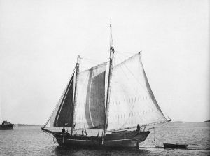
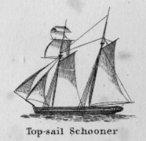
Schooners in Lane’s time were, with few exceptions, two-masted vessels carrying a fore-and-aft rig having one or two jibs, a fore staysail, gaff-rigged fore- and main sails, and often fore- and main topsails. One variant was the topsail schooner, which set a square topsail on the fore topmast. The hulls of both types were basically similar, their rigs having been chosen for sailing close to the wind. This was an advantage in the coastal trade, where entering confined ports required sailing into the wind and frequent tacking. The square topsail proved useful on longer coastwise voyages, the topsail providing a steadier motion in offshore swells, reducing wear and tear on canvas from the slatting of the fore-and-aft sails. (1)
Schooners of the types portrayed by Lane varied in size from 70 to 100 feet on deck. Their weight was never determined, and the term “tonnage” was a figure derived from a formula which assigned an approximation of hull volume for purposes of imposing duties (port taxes) on cargoes and other official levies. (2)
Crews of smaller schooners numbered three or four men. Larger schooners might carry four to six if a lengthy voyage was planned. The relative simplicity of the rig made sail handling much easier than on a square-rigged vessel. Schooner captains often owned shares in their vessels, but most schooners were majority-owned by land-based firms or by individuals who had the time and business connections to manage the tasks of acquiring and distributing the goods to be carried. (3)
Many schooners were informally “classified” by the nature of their work or the cargoes they carried, the terminology coined by their owners, agents, and crews—even sometimes by casual bystanders. In Lane’s lifetime, the following terms were commonly used for the schooner types he portrayed:
Coasting schooners: This is the most general term, applied to any merchant schooner carrying cargo from one coastal port to another along the United States coast (see Bar Island and Mt. Desert Mountains from Somes Settlement, 1850 (inv. 401), right foreground). (4)
Packet schooners: Like packet sloops, these vessels carried passengers and various higher-value goods to and from specific ports on regular schedules. They were generally better-maintained and finished than schooners carrying bulk cargoes (see The Old Fort and Ten Pound Island, Gloucester, 1850s (inv. 30), center; and Gloucester Inner Harbor, 1850 (inv. 240), stern view). (5)
Lumber schooners: Built for the most common specialized trade of Lane’s time, they were fitted with bow ports for loading lumber in their holds (see View of Southwest Harbor, Maine: Entrance to Somes Sound, 1852 (inv. 260)) and carried large deck loads as well (Stage Rocks and the Western Shore of Gloucester Outer Harbor, 1857 (inv. 8), right). Lumber schooners intended for long coastal trips were often rigged with square topsails on their fore masts (see Becalmed Off Halfway Rock, 1860 (inv. 344), left; ; and Lumber Schooner in a Gale, 1863 (inv. 552)). (6)
Schooners in other specialized trades. Some coasting schooners built for carrying varied cargoes would be used for, or converted to, special trades. This was true in the stone trade where stone schooners (like stone sloops) would be adapted for carrying stone from quarries to a coastal destination. A Lane depiction of a stone schooner is yet to be found. Marsh hay was a priority cargo for gundalows operating around salt marshes, and it is likely that some coasting schooners made a specialty of transporting this necessity for horses to urban ports which relied heavily on horses for transportation needs. Lane depicted at least two examples of hay schooners (see Gloucester Harbor, 1850s (inv. 391), left; and Coasting Schooner off Boon Island, c.1850 (inv. 564)), their decks neatly piled high with bales of hay, well secured with rope and tarpaulins.
– Erik Ronnberg
References:
1. Howard I. Chapelle, The History of American Sailing Ships (New York: W.W. Norton & Co., 1935), 258. While three-masted schooners were in use in Lane’s time, none have appeared in his surviving work; and Charles S. Morgan, “New England Coasting Schooners”, The American Neptune 23, no. 1 (DATE): 5–9, from an article which deals mostly with later and larger schooner types.
2. John Lyman, “Register Tonnage and its Measurement”, The American Neptune V, nos. 3–4 (DATE). American tonnage laws in force in Lane’s lifetime are discussed in no. 3, pp. 226–27 and no. 4, p. 322.
3. Ship Registers of the District of Gloucester, Massachusetts, 1789–1875 (Salem, MA: The Essex Institute, 1944). Vessels whose shipping or fishing voyages included visits to foreign ports were required to register with the Federal Customs agent at their home port. While the vessel’s trade or work was unrecorded, their owners and master were listed, in addition to registry dimensions and place where built. Records kept by the National Archives can be consulted for information on specific voyages and ports visited.
4. Howard I. Chapelle, The National Watercraft Collection (Washington, DC: Smithsonian Institution, 1960), 40, 42–43.
5. Ibid., 42–43, 73.
6. Ibid., 74–76.

In R. H. Dana, The Seaman's Friend, 13th ed. (Thomas Groom & Co. Publisher, 1873)
A topsail schooner has no tops at her foremast, and is fore-and-aft rigged at her mainmast. She differs from an hermaphrodite brig in that she is not properly square-rigged at her foremast, having no top, and carrying a fore-and-aft foresail instead of a square foresail and a spencer.

Detail views: marine railway and hauling cradle for vessel Wood rails, metal rollers, chain; wood cradle. Scale: ½" = 1' (1:24) Original diorama components made, 1892; replacements made, 1993. Cape Ann Museum, from Gloucester Chamber of Commerce, 1925 (2014.071)
A schooner is shown hauled out on a cradle which travels over racks of rollers on a wood and metal track.
Also filed under: Burnham Brothers Marine Railway » // Marine Railways »

c. 1900 Glass plate negative Collection of Erik Ronnberg
Also filed under: Lobstering »
"The Maine Register for the Year 1855, embracing State and County Officers, and an abstract of the law and resolves; together with a complete business directory of the state, and a variety of useful information."
Details about Maine's lumber trade in 1855, see pp. 250–52
Also filed under: Castine » // Lumber Industry »
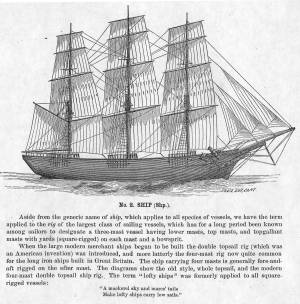
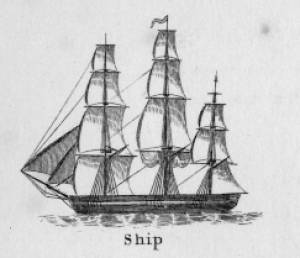
The term "ship," as used by nineteenth-century merchants and seamen, referred to a large three-masted sailing vessel which was square-rigged on all three masts. (1) In that same period, sailing warships of the largest classes were also called ships, or more formally, ships of the line, their size qualifying them to engage the enemy in a line of battle. (2) In the second half of the nineteenth century, as sailing vessels were replaced by engine-powered vessels, the term ship was applied to any large vessel, regardless of propulsion or use. (3)
Ships were often further defined by their specialized uses or modifications, clipper ships and packet ships being the most noted examples. Built for speed, clipper ships were employed in carrying high-value or perishable goods over long distances. (4) Lane painted formal portraits of clipper ships for their owners, as well as generic examples for his port paintings. (5)
Packet ships were designed for carrying capacity which required some sacrifice in speed while still being able to make scheduled passages within a reasonable time frame between regular destinations. In the packet trade with European ports, mail, passengers, and bulk cargos such as cotton, textiles, and farm produce made the eastward passages. Mail, passengers (usually in much larger numbers), and finished wares were the usual cargos for return trips. (6) Lane depicted these vessels in portraits for their owners, and in his port scenes of Boston and New York Harbors.
Ships in specific trades were often identified by their cargos: salt ships which brought salt to Gloucester for curing dried fish; tea clippers in the China Trade; coffee ships in the West Indies and South American trades, and cotton ships bringing cotton to mills in New England or to European ports. Some trades were identified by the special destination of a ship’s regular voyages; hence Gloucester vessels in the trade with Surinam were identified as Surinam ships (or barks, or brigs, depending on their rigs). In Lane’s Gloucester Harbor scenes, there are likely (though not identifiable) examples of Surinam ships, but only the ship "California" in his depiction of the Burnham marine railway in Gloucester (see Three Master on the Gloucester Railways, 1857 (inv. 29)) is so identified. (7)
– Erik Ronnberg
References:
1. R[ichard)] H[enry] Dana, Jr., The Seaman’s Friend, 13th ed. (Boston: Thomas Groom & Co., 1873), p. 121 and Plate IV with captions.
2. A Naval Encyclopaedia (Philadelphia: L. R. Hamersly & Co., 1884), 739, 741.
3. M.H. Parry, et al., Aak to Zumbra: A Dictionary of the World’s Watercraft (Newport News, VA: The Mariners’ Museum, 2000), 536.
4. Howard I. Chapelle, The History of American Sailing Ships (New York: W.W. Norton & Co., 1935), 281–87.
5. Ibid.
6. Howard I. Chapelle, The National Watercraft Collection (Washington, DC: Smithsonian Institution, 1960), 26–30.
7. Alfred Mansfield Brooks, Gloucester Recollected: A Familiar History (Gloucester, MA: Peter Smith, 1974), 67–69.
Photograph
From American Clipper Ships 1833–1858, by Octavius T. Howe and Frederick C. Matthews, vol. 1 (Salem, MA: Marine Research Society, 1926).
Photo caption reads: "'Golden State' 1363 tons, built at New York, in 1852. From a photograph showing her in dock at Quebec in 1884."
Also filed under: "Golden State" (Clipper Ship) »
_sm.jpg)

Oil on canvas
24 x 35 in.
Peabody Essex Museum, Salem, Mass.
Walters' painting depicts the "Nonantum" homeward bound for Boston from Liverpool in 1842. The paddle-steamer is one of the four Clyde-built Britannia-class vessels, of which one is visible crossing in the opposite direction.
View related catalogue entries (2) »
Also filed under: Packet Shipping » // Walters, Samuel »
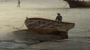
The yawl boat was a ninteenth-century development of earlier ships' boats built for naval and merchant use. Usually twenty feet long or less, they had round bottoms and square sterns; many had raking stem profiles. Yawl boats built for fishing tended to have greater beam than those built for vessels in the coastal trades. In the hand-line fisheries, where the crew fished from the schooner's rails, a single yawl boat was hung from the stern davits as a life boat or for use in port. Their possible use as lifeboats required greater breadth to provide room for the whole crew. In port, they carried crew, provisions, and gear between schooner and shore. (1)
Lane's most dramatic depictions of fishing schooners' yawl-boats are found in his paintings Gloucester Outer Harbor, from the Cut, 1850s (inv. 109) and /entry:311. Their hull forms follow closely that of Chapelle's lines drawing. (2) Similar examples appear in the foregrounds of Gloucester Harbor, 1852 (inv. 38), Ships in Ice off Ten Pound Island, Gloucester, 1850s (inv. 44), and The Fort and Ten Pound Island, Gloucester, Massachusetts, 1847 (inv. 271). A slightly smaller example is having its bottom seams payed with pitch in the foreground of Gloucester Harbor, 1847 (inv. 23). In Gloucester Inner Harbor, 1850 (inv. 240), a grounded yawl boat gives an excellent view of its seating arrangement, while fishing schooners in the left background have yawl boats hung from their stern davits, or floating astern.
One remarkable drawing, Untitled, n.d. (inv. 219) illustrates both the hull geometry of a yawl boat and Lane's uncanny accuracy in depicting hull form in perspective. No hull construction other than plank seams is shown, leaving pure hull form to be explored, leading in turn to unanswered questions concerning Lane's training to achieve such understanding of naval architecture.
– Erik Ronnberg
References:
1. Howard I. Chapelle, American Small Sailing Craft (New York: W.W. Norton & Co., 1951), 222–23.
2. Ibid., 223.
Oil on canvas
12 1/8 x 19 3/4 in.
Museum of Fine Arts, Boston, Bequest of Martha C. Karolik for the M.and M. Karolik Collection of American Paintings, 1815-1865 (48.447)
A schooner's yawl lies marooned in the ice-bound harbor in this detail.