An online project under the direction of the CAPE ANN MUSEUM
Catalogue Entry
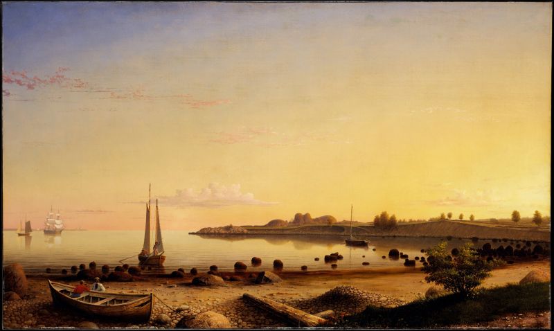
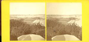
Bathed in the light of a summer’s late afternoon, this painting shows the overgrown Stage Fort, which was a relic of the seventeenth-century settlement of Gloucester. The dramatic evening light and still water make this a quiet picture, similar to some of Lane's other late works.
This southerly view looks out over Gloucester Harbor with Stage Rock, Tablet Rock, and Fishermen’s Field (now Stage Fort Park) in the right half. At far left in the distance lies Eastern Point and its light house.The foreground lies just west of the Cut where the Annisquam River joins the harbor. Afloat in the distance, a schooner and a full-rigged ship lie becalmed while a small schooner boat approaches the shore in the foreground. Further right in the cove, a cat-rigged yawl boat lies at anchor.
The tranquility and restful colors in this scene are reflective of Lane’s advancing age and his thoughts on the past. The beached and time-worn hull of a New England boat picks up on a vessel type he portrayed over a span of nearly two decades, with each succeeding painting showing the craft in a further stage of deterioration. The wreck depicted here will become the broken frames and bottom plank lying on the beach at Norman’s Woe Cove in another large painting completed the same year (Norman's Woe, Gloucester Harbor, 1862 (inv. 1)).
None of the vessels in the painting were depicted in the drawing (Gloucester Outer Harbor, from the Cut, 1850s (inv. 109) and Untitled, n.d. (inv. 222) combined) and only parts of the latter’s foreground were changed by adding vegetation and driftwood to the painting. The rest of the image remains faithful to the drawing.
This is one of Lane’s largest paintings, the image being 1-1/2 times larger than the drawing. The drawing, Gloucester Outer Harbor, from the Cut, 1850s (inv. 109), for this picture indicates that a painting for Lane's friend Mrs. H. E. Davidson was made after the drawing. Whether this painting is the one referred to by the inscription on the drawing is unknown. Dr. H.E. Davidson was Lane's doctor, as well as a good friend, and the Davidsons owned several Lane pictures, including his unusual Dream Painting, 1862 (inv. 74).
Also unproven, but also very likely, is that this is the painting described in an article in the Cape Ann Advertiser from January 1862. Such an identification would support the idea that this is the Davidson picture.
F.H.Lane, Esq., has recently completed a picture for Dr. H.E. Davidson of this town. The painting represents a sunset scene in our harbor, which is taken near the cut bridge, introducting the beach covered with rocks and pebbles, steep bank, and Stage Fort. . .
– Melissa Geisler Trafton and Erik Ronnberg
Historical Materials
Newsprint
Cape Ann Advertiser
Collection of Fred and Stephanie Buck
"VISIT TO LANE'S STUDIO.
We called at the studio of this artist a few days ago, and found several new paintings had been added to his collection since our last visit. The first that arrested our attention was a view of Good Harbor Beach. . . .
A scene outside Eastern Point, during a fresh sou'wester, is full of life, and faithfully portrayed on the canvass. . . .
A fancy sketch, representing a storm scene, is also on exhibition. . . .
The Artist has now on his easel a large picture 36x60, just commenced, which we should judge would be his master-piece. It will be on exhibition when finished, and we forbear a description of it at this time. Mr. Lane, as a marine painter, ranks first in the country, and we are pleased to chronicle his success in producing such life-like pictures."
Newspaper clipping
Cape Ann Advertiser
Collection of Fred and Stephanie Buck
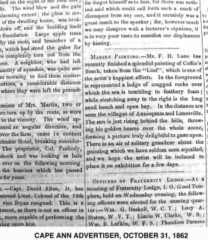
"MARINE PAINTING. – F. H. Lane, Esq., has recently completed a picture for Dr. H. E. Davidson of this town. The painting represents a sunset scene in our harbor, which is taken near the cut bridge, introducing the beach covered with rocks and pebbles, steep bank, and Stage Fort, with the surrounding scenery in the vicinity. . . It is impossible to give an adequate idea of this painting by any description of ours, for it must be seen to be appreciated. It is the largest painting the artist has yet finished, and, in our opinion, his best. The painting is now on exhibition at the Studio, for a short time, where those who are interested in works of art can have an opportunity of viewing it."
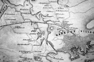
Steepbank (sometimes spelled "Steep Bank") was a house near Fresh Water Cove which, in Lane's time, served as a summer estate for brothers, Eben and Theron Dale. It had been built for “an artist” named “Mr. Eddy” in 1845, was next owned by a “Mr. Homer,” and then by a “Mr. C. B. Fessenden." Around 1858 it was purchased by Eben Dale.
Commonwealth of Massachusetts: Southern Essex District Registry of Deeds
1543 plan 0141_0002
The third of the three plans has the references on it. "Plan showing the taking of land, flats and beach for Stage Fort Park…1898..."
Includes a reference to the home of Mary Turnbull which is Steepbank.
Also filed under: Maps » // Stage Rocks / Stage Fort / Stage Head »
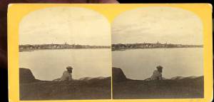
c.1870 Stereograph card Cape Ann Museum Library & Archive
Also filed under: Gloucester – City Views » // Half Moon Beach » // Historic Photographs » // Stage Rocks / Stage Fort / Stage Head »
Newsprint
From bound volume owned by publisher Francis Procter
Collection of Fred and Stephanie Buck
"We visited the studio of Mr. Fitz H. Lane a few days since, and were much pleased in examining some fine paintings from the pencil of this talented artist. Among the collection was a view of Long Beach, in this town, with which we were particularly interested.
The scene is taken immediately after a storm. The waves with their snowy crests are rolling in upon the beach, breaking against the sides of a vessel which has been driven ashore. In the background is seen the residence of Mr. Fessenden, and the surrounding scenery; on the right are visible the high headlands near the residence of Mr. Geo. Hovey, while stretching far away in the distance may be seen Fresh Water Cove, Dolliver's Neck, and the Old Pine Tree, the whole forming a beautiful picture and true to Nature.
Several other paintings were in process of completion, one a beautiful sunset scene, which was really beautiful to gaze upon; also a view of a gale at sea, with a gallant ship plunging madly through the waves, forming a striking contrast to the mild placid scene of the picture at its side.
Mr. Lane's paintings are true to nature, and in viewing them one can but admire the skill and genius of this talented artist, We advise all lovers of the art, who wish to spend an hour pleasantly, to visit the studio of Mr. Lane on Locust St. We can assure them that they will come away highly gratified, and have an earnest desire to call again." (1)
(1) See p. 2, column 3, Courtesy of the American Antiquarian Society
Also filed under: Chronology » // Dolliver's Neck » // Fessenden, C. B. » // Fresh Water Cove » // Lone Pine » // Newspaper / Journal Articles » // Studio Descriptions »

44 x 34 in.
Henry Francis Walling, Map of the Towns of Gloucester and Rockport, Essex Co. Massachusetts. Philadelphia, A. Kollner, 1851
Cape Ann Museum Library & Archive
"Map of the Towns of Gloucester and Rockport, Massachusetts. H.F. Walling, Civil Engineer. John Hanson, Publisher. 1851. Population of Gloucester in 1850: 7,805. Population of Rockport in 1850: 3,213."
Also filed under: Annisquam River » // Brookbank » // Dolliver's Neck » // Fresh Water Cove » // Gloucester Harbor, Outer » // Maps » // Norman's Woe » // Stage Rocks / Stage Fort / Stage Head » // West Gloucester – Little River » // Western Shore »
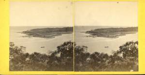
c.1860 Stereograph card Cape Ann Museum Library & Archive
Taken from Steepbank, on the western side of Gloucester Harbor, and showing a small boat at anchor in the cove, then the Neck, and the sea beyond.
Also filed under: Dolliver's Neck » // Fresh Water Cove » // Historic Photographs » // Lone Pine »
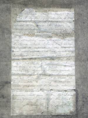
Letter
Cape Ann Museum Library & Archive, Gloucester, Mass.
". . . will fully appreciate all that I have done in my garden, in ornamenting it, with flowers and plants, Rustic Arbours and Statues, and I only wish that you could be here to witness and enjoy his [Dr. J. L. Stevens] expressions of delight and interest, when a new flower attracts his attention, or some beauty of arrangement meets his eye. Samuel [B. Stevens of Castine] he tells me came up with the expectation of going on a voyage to Australia, but when he arrived in Boston he found the vessel with her compliment of men, and it is very uncertain if he goes in her. Your Mother and all at home are well. I yesterday made a sketch of Stage Fort and the surrounding scenery, from the water. Piper has given me an order for a picture from this point of view, to be treated as a sunset. I shall try to make something out of it, but it will require some management, as there is no foreground but water and vessels. One o’clock, it is very hot, the glass indicates 84° in my room, with the windows all open and a light breeze from the east, this is the warmest day . . .
. . . than devoting it to you. Since writing you last I have painted but one picture worth talking about and that one I intend for you if you should be pleased with it. It is a View of the beach between Stage Fort and Steep bank including Hovey’s Hill and residence, Fresh water cove and the point of land with the lone pine tree. Fessenden’s house, likewise comes into the picture. The effect is a mid day light with a cloudy sky, a patch of sunlight is thrown across the beach and the breaking waves, an old vessel lies stranded on the beach with two or three figures, there are a few vessels in the distance and the Field rocks likewise show at the left of the picture. I think you will be pleased with this picture, for it is a very picturesque scene especially the beach, as there are many rocks which come in to destroy the monotony of a plain sand beach, and I have so arranged the light and shade that the effect I think is very good indeed, however you will be better able to judge of that when you see it, the size is 20 x 33. . ."
Commonwealth of Massachusetts: Southern Essex District Registry of Deeds
1543 plan 0141_0001
The third of the three plans has the references on it “Plan showing the taking of land, flats and beach for Stage Fort Park…1898…”
Includes a reference to the home of Mary Turnbull which is Steepbank.
Also filed under: Field Beach / Crescent (or Cressy's) Beach / Long Beach » // Maps » // Stage Rocks / Stage Fort / Stage Head »
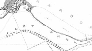
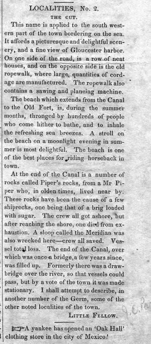
The Cut is the local name given to the canal that connects the outer Gloucester harbor to the navigable Annisquam River and thence on to the waters north of Cape Ann, so that vessels can in safety avoid circling the entire exposed eastern shoreline. It provided a vantage point for Lane's drawing Gloucester Beach from the Cut, 1850s (inv. 103) It was dug through the strip of beach separating the two bodies of water, first in the 1640s by the Reverend Richard Blynman, and is officially the Blynman Canal. This is purportedly the first canal dug in North America. For much of its history, however, the Cut has been filled in and the beach in its original state with a road laid over it, instead of cut through with a bridge over the canal (until 1950 and Route 128, the only vehicular access from the mainland to the Gloucester and Rockport peninsula). For a brief time around 1704 the canal was filled in by a storm but was soon dredged and re-opened. Then in 1723 it was again filled in by storms and did not get dug out until after 1822.
At this time, a consortium of Gloucester's leading men, most of them connected then and later with Lane, formed the company "Proprietors of the Gloucester Canal." They included Benjamin K. Hough, Jr.; James Mansfield; William Pearce, Jr.; John Mason; William Saville; Samuel Gilbert; and Winthrop Sargent. They managed to get the canal re-dug and a bridge in place, but the opening was too narrow to allow vessels of useful size to pass through. The bridge was also deemed unsafe. The company lost money and by 1843, the Cut was being refilled by the Town. During all the rest of Lane's life, the Cut as a canal did not exist. One could travel on a road, over sand, from the Pavilion, past the Ropewalk and the houses along the shore, to the western shores of the Harbor, Brookbank, Fresh Water Cove, and many other scenes and sites from which Lane painted. However, Lane and others continued to designate that section of their town as "The Cut."
After Lane's death, the quarrying interests on Wolf Hill (near the eastern end of the A. Piatt Andrew Bridge) were sufficiently motivated to reopen the canal in 1867.
– Sarah Dunlap (December, 2014)
1851 44 x 34 in. Henry Francis Walling, Map of the Towns of Gloucester and Rockport, Essex Co. Massachusetts. Philadelphia, A. Kollner, 1851 Cape Ann Museum Library & Archive
"Map of the Towns of Gloucester and Rockport, Massachusetts. H.F. Walling, Civil Engineer. John Hanson, Publisher. 1851. Population of Gloucester in 1850 7,805. Population of Rockport in 1850 3,213."
Also filed under: Babson House » // Town / Public Landings » // White-Ellery House »
1848 Newsprint D14-7 Cape Ann Museum Library & Archive
A short article entitled "The Cut," and signed "Little Fellow" describes the southwestern part of Gloucester and the beach between the Canal and the Old Fort.
Also filed under: Piper, John J. » // Ropewalk »
Personal journal
Wilson Museum, Castine, Maine
Box 2, F1 (A00772)
John Stevens was the younger brother of Joseph Stevens, and acquainted with Lane, spending time with him in Gloucester and at the family home in Castine. His journal, quoted below, includes reference to hunting plover and teal, school, sailing, local events. Mentions Castine mill, lighthouse, and block house.
"Friday [September] 17th: Cloudy all day. Wind N. blowing quite hard. A British Rig loaded with salt from Liverpool came into port last night. She run way up by the Monument and got aground. They kedged her off this P.M. and came down. She came in with one of these old English charts as her guide. They have the town set down on the Brooksville side, two miles + three quarters from the lighthouse."
"Wednesday [September] 22. . .Went down to the Indians Camp on the Back Cove. There were five camps of them."
Visits Gloucester from Castine:
"Wednesday [October] 27th. . .Left for Gloucester [from Boston] at 5 o'clock this P.M. arrived there safe + sound at 6 1/2 o'clock; went right down to the store and saw Joe. We then went up to his house and got supper.
"Thursday [October] 28th. At. Gloucester. Pleasant day. Went down to the "Cut" a gunning this morning before breakfast but saw no birds. Went out in the harbor this forenoon alone, had a fine sail but couldn't get a chance at any birds. Went out again this P.M. got down to East Point Light and the wind died all away, so I had to scull home."
"Friday 29th. Very pleasant day, went out in the harbor this morning with Joe. Took a walk this A.M. with "Lina", called on Mr. Lane + Doct. Hildreth. Joe + I went out in the harbor this P.M. I fired at some birds several times, but didn't get any. . . ."
Also filed under: Biographical information » // Bird Hunting » // Castine » // Castine – School » // Chronology » // Diaries / Ledgers / Etc. » // Stevens, Joseph, Jr. »
Newsprint
Gloucester Telegraph
"The Reef of Norman's Woe ... is now commemorated in painting too, one of the finest pictures from Lane's easel. ... The sketch was made at the pretty spot commonly called, we believe, Master Moore's Cove. Being some little way off the main track to Rafe's Chasm, it is seldom visited, except by the more inquisitive lovers of nature who leave the beaten road to pry out such pleasant places. ... We wish it might find a home buyer, rather than go off to enrich another community." Flowery description follows, then "There is another and larger work in the artist's studio, which, happily, is to be retained. It received much well deserved notice and commendation. The subject is a view southward from the 'Cut,' with the picturesque promontory commonly known as 'Stage Fort,' and historically interesting as the supposed spot of the 'Landing at Cape Ann' in the middle distance, and Eastern Point on the extreme left." More description follows, "Among other attractions of the studio, and particularly worthy of mention, is a cabinet picture with an effect similar to the Norman's Woe. The subject is chosen from the many sketches of the grand scenery of the Maine sea-coast with which the artist's portfolio is rich. It is a view of the Camden mountains sketches from the Graves, a jagged ledge far out in the bay, which is accessible in only the smoothest water."
Also filed under: Camden Mountains » // Newspaper / Journal Articles » // The Graves »
Gloucester Outer Harbor served as a staging area for deep draft or heavily laden vessels waiting to come into the wharves in the shallow Old Harbor at high tide, or waiting to discharge cargo into smaller vessels. While Lane's paintings typically show one or two vessels in the harbor, works by other artists from the period, as well as contemporary descriptions, demonstrate that the harbor was usually crowded with vessels, especially in bad weather. The Outer Harbor could accommodate as many as three hundred vessels when they needed to shelter during a storm.
There were two deep spots where they could wait, the "Deep Hole" between Ten Pound Island and the Fort; and the "Pancake Grounds" between Ten Pound Island and Eastern Point. The "Pancake Grounds" also served as a quarantine area for ships arriving from foreign ports. "Deep Hole" was named for the (relatively) deep water between Rocky Neck and Fort Point to the Outer Harbor. Deeply loaded vessels had to anchor there for “lightering” (partial unloading by boats called “lighters”) prior to final unloading at wharfside. "Deep Hole" was 20–25 feet deep at low tide, when Harbor Cove was only 1–6 feet deep with bare ground around some wharves. "Deep Hole" is where you see ships anchored in Gloucester Harbor from Rocky Neck, 1844 (inv. 14), The Old Fort and Ten Pound Island, Gloucester, 1850s (inv. 30), , Gloucester Inner Harbor, 1850 (inv. 240), The Fort and Ten Pound Island, Gloucester, Massachusetts, 1847 (inv. 271), and Gloucester Harbor, 1848 (inv. 335) (which is coming to anchor).
The term "Deep Hole" is apparently a post-Bellum term. Prior to that, it was known as "The Stream" and, as later, served as anchorage where deeply loaded vessels could be lightered prior to docking in Harbor Cove. Alfred Mansfield Brooks in his book Gloucester Recollected uses this term on page 53. After the Civil War, merchant shipping in Gloucester was dominated by salt ships and later coal carriers, bringing a whole new culture to the harbor, and with it new names for old places.

John Heywood Photo for Hervey Friend
Cape Ann Museum Library & Archive (2013.068)
Schooners anchored on the Pancake Ground, taken from from Wonson's Cove, easterly side of the Rocky Neck causeway. Eastern Point Fort and garrison in background to far left.
Also filed under: Eastern Point »

c.1870 Stereograph card Procter Brothers, Publisher Cape Ann Museum Library & Archive
"Gloucester Harbor from Rocky Neck, Looking Southwest. This gives a portion of the Harbor lying between Ten Pound Island and Eastern Point. At the time of taking this picture the wind was from the northeast, and a large fleet of fishing and other vessels were in the harbor. In the range of the picture about one hundred vessels were at anchor. In the small Cove in the foreground quite a number of dories are moored. Eastern Point appears on the left in the background."
Southeast Harbor was known for being a safe harbor.
Also filed under: Historic Photographs » // Rocky Neck » // Schooner (Fishing) » // Small Craft – Wherries, and Dories »

Collection of Erik Ronnberg
View related catalogue entries (2) »
Also filed under: Dolliver's Neck » // Fresh Water Cove » // Gloucester Harbor, Inner / Harbor Cove » // Maps »

c.1870 Stereograph card Procter Brothers, Publisher Cape Ann Museum Library & Archive
View from Civil War fort on Eastern Point.
Also filed under: Eastern Point » // Historic Photographs »

44 x 34 in.
Henry Francis Walling, Map of the Towns of Gloucester and Rockport, Essex Co. Massachusetts. Philadelphia, A. Kollner, 1851
Cape Ann Museum Library & Archive
"Map of the Towns of Gloucester and Rockport, Massachusetts. H.F. Walling, Civil Engineer. John Hanson, Publisher. 1851. Population of Gloucester in 1850: 7,805. Population of Rockport in 1850: 3,213."
Also filed under: Annisquam River » // Brookbank » // Dolliver's Neck » // Fresh Water Cove » // Maps » // Norman's Woe » // Stage Rocks / Stage Fort / Stage Head » // Steepbank » // West Gloucester – Little River » // Western Shore »
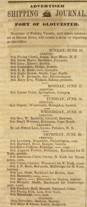
Newsprint
Cape Ann Advertiser
Cape Ann Museum Library & Archive
Notice in the Cape Ann Advertiser announcing arrival of ships into the port of Gloucester, with details of their cargo.
Also filed under: Newspaper / Journal Articles » // Trade Routes and Statistics »
Newspaper
"Lane's studio seldom presents so many attractions to visitors as at the present time. With unwonted rapidity his easel has turned off pictures in answer to the numerous orders which have poured in from all quarters."
Also filed under: Chronology » // Newspaper / Journal Articles » // Studio Descriptions »
Electrotype impression
Collection of Erik Ronnberg
Also filed under: Gloucester Harbor, Inner / Harbor Cove » // Maps »

c.1870 Stereograph card Procter Brothers, Publisher Cape Ann Museum Library & Archive
Also filed under: Historic Photographs » // Stage Rocks / Stage Fort / Stage Head »

Pencil and ink on paper
15 x 22 1/8 in.
Cape Ann Museum, Gloucester, Mass., Gift of Mr. Donald K. Usher, in memory of Mrs. Margaret Campbell Usher, 1984 (2401.19)
Also filed under: Beacons / Monuments / Spindles » // Mackerel Fishing »

Watercolor on paper
8 3/4 x 19 3/4 in.
Cape Ann Museum, Gloucester, Mass., Gift of Rev. and Mrs. A. A. Madsen, 1950
Accession # 1468
Fishing schooners in Gloucester's outer harbor, probably riding out bad weather.
Also filed under: Elwell, D. Jerome » // Schooner (Fishing) »
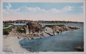
The Stage, as it was known in Lane’s time, now Stage Fort Park, rises from the western shore of the Outer Harbor, just south and west of the Cut and the Blynman Bridge as you leave Gloucester. This was the first settlement of the Massachusetts Bay Colony in 1623 where fourteen men of the Dorchester Company landed and tried in vain to settle and survive through a combination of fishing and farming. They were successful at neither, and in 1626 they moved on and founded Salem.
During the Revolution the Gloucester patriots built a fort on the north side of Half Moon Beach to defend against British invaders which was never needed. The fort was restored for the War of 1812 and again for the Civil War, but again saw no action.
During Lane’s lifetime this area was the Hough farm. Townspeople were generally given free run of the place for strolling and picnics overlooking the harbor. The enormous rounded boulders and ledge outcroppings rose dramatically from the fields above the harbor without the tree cover that partially obscures them today.
Lane did numerous paintings of this area, including many views looking westward from the vantage point onboard a boat in the harbor. In Stage Rocks and the Western Shore of Gloucester Outer Harbor, 1857 (inv. 8) the Stage Rocks frame the west side of Gloucester Harbor and provided a peaceful and bucolic counterpoint to the intense activity of the city waterfront only a mile away across the harbor. Lane also painted the Stage Rocks from the beach just to the north near the Cut and Field Beach, which is on the southern side of the Stage Rocks facing out the harbor entrance to the sea.
Commonwealth of Massachusetts: Southern Essex District Registry of Deeds
1543 plan 0141_0002
The third of the three plans has the references on it. "Plan showing the taking of land, flats and beach for Stage Fort Park…1898..."
Includes a reference to the home of Mary Turnbull which is Steepbank.
Also filed under: Maps » // Steepbank »
c.1870 Stereograph card Cape Ann Museum Library & Archive
Also filed under: Gloucester – City Views » // Half Moon Beach » // Historic Photographs » // Steepbank »
44 x 34 in.
Henry Francis Walling, Map of the Towns of Gloucester and Rockport, Essex Co. Massachusetts. Philadelphia, A. Kollner, 1851
Cape Ann Museum Library & Archive
"Map of the Towns of Gloucester and Rockport, Massachusetts. H.F. Walling, Civil Engineer. John Hanson, Publisher. 1851. Population of Gloucester in 1850: 7,805. Population of Rockport in 1850: 3,213."
Also filed under: Annisquam River » // Brookbank » // Dolliver's Neck » // Fresh Water Cove » // Gloucester Harbor, Outer » // Maps » // Norman's Woe » // Steepbank » // West Gloucester – Little River » // Western Shore »
c.1870 Stereograph card Cape Ann Museum Library & Archive
Also filed under: Half Moon Beach » // Historic Photographs » // Western Shore »
c.1870 Stereograph card Cape Ann Museum Library & Archive
Also filed under: Gloucester – City Views » // Historic Photographs »
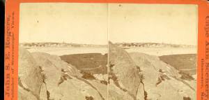
c.1890 Stereograph card Cape Ann Museum Library & Archive
"In the foreground is a clear sheet of water which washes upon the beach beyond. The Pavilion is quite prominent, while upon the rising background can be seen the steeples of the several churchs, the tower of the first Town House, and the Collins School House."
Also filed under: Gloucester – City Views » // Historic Photographs » // Pavilion Hotel »
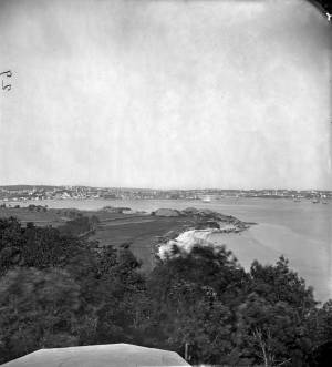
Cape Ann Museum Library & Archive
Stage Fort from Hough's Farm, showing a panorama of the harbor from Pavilion Beach to Fort Point and Rocky Neck.
Also filed under: Field Beach / Crescent (or Cressy's) Beach / Long Beach »
c.1870 Stereograph card Procter Brothers, Publisher Cape Ann Museum Library & Archive
Also filed under: Gloucester Harbor, Outer » // Historic Photographs »
Commonwealth of Massachusetts. Southern Essex District Registry of Deeds. 1543 plan 0141_0003
salemdeeds.com
The third of the three plans has the references on it “Plan showing the taking of land, flats and beach for Stage Fort Park…1898…"
Includes a reference to the home of “Mary Turnbull” which is Steepbank.
Also filed under: Maps »
Commonwealth of Massachusetts: Southern Essex District Registry of Deeds
1543 plan 0141_0001
The third of the three plans has the references on it “Plan showing the taking of land, flats and beach for Stage Fort Park…1898…”
Includes a reference to the home of Mary Turnbull which is Steepbank.
Also filed under: Field Beach / Crescent (or Cressy's) Beach / Long Beach » // Maps » // Steepbank »
Colored lithograph
Cape Ann Museum Library and Archive
Also filed under: Western Shore »
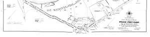
29 x 25 in.
Cape Ann Museum Library & Archive (#089)
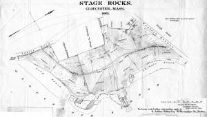
Ernest Bowditch was a landscape gardener. This map shows some of the various names of landmarks around Stage Rocks.
Also filed under: Field Beach / Crescent (or Cressy's) Beach / Long Beach » // Half Moon Beach » // Maps »
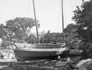
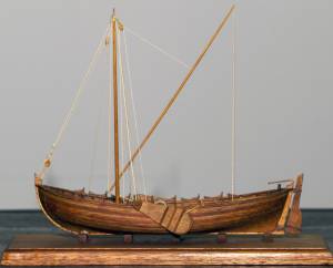
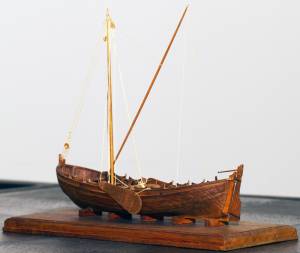
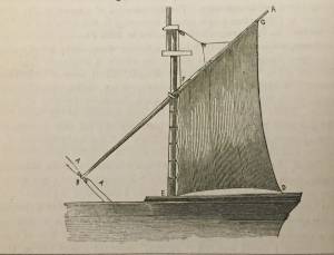
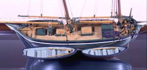
The colonial American shallop is the ancestor of many regional types of New England fishing craft found in Lane's paintings and drawings, including "New England Boats" (known as "boats"), and later descendents, such as "Chebacco Boats," "Dogbodies," and "Pinkies." (discussed elsewhere)
These boats were very common work boat types on Cape Ann throughout the 1800s. They were primarily used for inshore coastal fishing, which included lobstering, gill-netting, fish-trapping, hand-lining, and the like. They were usually sailed by one or two men, sometimes with a boy, and could be rowed as well as sailed. An ordinary catch would include rock cod, flounder, fluke, dabs, or other small flat fish. The catch would be eaten fresh, or salted and stored for later consumption, or used as bait fish. Gill-netting would catch herring and alewives when spawning. Wooden lobster traps were marked with buoys much as they are today, and hauled over the low sides of the boat, emptied of lobsters and any by-catch, re-baited and thrown back.
THE SHALLOP
Like other colonial vessel types, shallops were defined in many ways, including size, construction, and rig. Most commonly, they were open boats with square or sharp sterns, 20 to 30 feet in length, two-masted rigs, and heavy sawnframe construction which in time became lighter. (1)
The smaller shallops developed into a type called the Hampton Boat early in the nineteenth century, becoming the earliest named regional variant of what is now collectively termed the New England Boat. Other variants were named for their regions of origin: Isles of Shoals Boat, Casco Bay Boat, No Mans Land Boat, to name a few. No regional name for a Cape Ann version has survived, and "boat," or "two-masted boat" seems to have sufficed. (2)
Gloucester's New England Boats were mostly double-enders (sharp sterns) ranging in length from 25 to 30 feet, with two masts and two sails (no bowsprit or jib). They were used in the shore fisheries: handlining, gillnetting, and gathering or trapping shellfish (see View from Kettle Cove, Manchester-by-the-Sea, 1847 (inv. 94), View of Gloucester Harbor, 1848 (inv. 97), and /entry: 240/). (3)
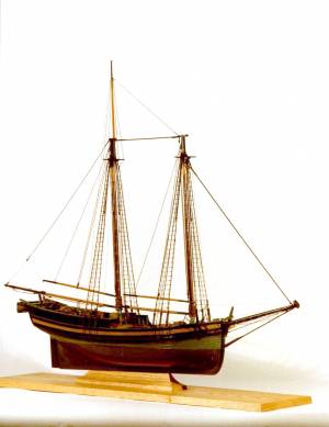
Larger, double-ended shallops became decked and evolved in Ipswich (the part now called Essex) to become Chebacco Boats. (4) This variant retained the two-mast, two-sail rig, but evolved further, acquiring a bowsprit and jib and becoming known as a pinky (see Gloucester Harbor from Rocky Neck, 1844 (inv. 14), The Western Shore with Norman's Woe, 1862 (inv. 18), and The Old Fort and Ten Pound Island, Gloucester, 1850s (inv. 30)). The Chebacco Boat became a distinct type by the mid-eighteenth century giving rise to the pinky in the early ninetennth century; the latter, by the early 1900s. (5)
References:
1. William A. Baker, Sloops & Shallops (Barre, MA: Barre Publishing Co., 1966), 27–33; and “Vessel Types of Colonial Massachusetts,” in Seafaring in Colonial Massachusetts (Boston: The Colonial Society of Massachusetts, 1980), 13–15, see figs. 10, 11.
2. Howard I. Chapelle, American Small Sailing Craft (New York: W.W. Norton & Co., 1951), 136–45.
3. Ibid., 145, upper photo, fourth page of plates.
4. Baker, 82–91.
5. Chapelle, The American Fishing Schooners, 1825–1935 (New York: W.W. Norton & Co., 1973), 23–54.
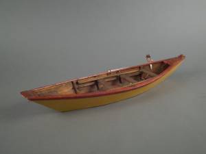
THE NEW ENGLAND BOAT
By the 1840s, the Gloucester version of the New England Boat had evolved into a distinct regional type. Referred to locally as “boats,” the most common version was a double-ender, i.e. having a pointed stern, unlike the less common version having a square stern.
Both variants had two masts, a foresail, a mainsail, but no bowsprit or jib. Lane depicted both in several paintings, beginning in the mid-1840s (see View from Kettle Cove, Manchester-by-the-Sea, 1847 (inv. 94), View of Gloucester Harbor, 1848 (inv. 97), and /entry: 240/), all ranging 25 to 30 feet in length. In View of Gloucester Harbor, 1848 (inv. 97) and Gloucester Inner Harbor, 1850 (inv. 240), a double-ender can be seen on the beach while a square-stern version lies at anchor in the harbor, just to the right of the former. (1)
Lane’s depictions of the double-enders show lapstrake hull planking in View of Gloucester Harbor, 1848 (inv. 97) and Gloucester Inner Harbor, 1850 (inv. 240), and cuddies (short decking) inboard at the ends for shelter and stowage of fishing gear in View from Kettle Cove, Manchester-by-the-Sea, 1847 (inv. 94). The few square-stern examples (see View of Gloucester Harbor, 1848 (inv. 97) and Gloucester Inner Harbor, 1850 (inv. 240)) suggest carvel (smooth) planking and paint finish, rather than oil and tar. The presence of an example of the latter variant in Boston Harbor, as noted in Boston Harbor, c.1850 (inv. 48), suggests a broader geographical range for this subtype. (2)
The primary use of Cape Ann’s “boats” was fishing, making “day trips” to coastal grounds for cod, herring, mackerel, hake, flounder, and lobster, depending on the season. Fishing gear included hooks and lines, gill nets, and various traps made of wood and fish net.
Some boats worked out of Gloucester Harbor, but other communities on Cape Ann had larger fleets, such as Sandy Bay, Pigeon Cove, Folly Cove, Lanesville, Bay View, and Annisquam. Lane’s depictions of these places and their boats are rare to nonexistent. (3)
The double-ended boat served Lane in marking the passage of time in Gloucester Harbor. In View from Kettle Cove, Manchester-by-the-Sea, 1847 (inv. 94), we see new boats setting out to fish, but in View of Gloucester Harbor, 1848 (inv. 97) and Gloucester Inner Harbor, 1850 (inv. 240), a boat of the same type is depicted in a progressively worn state. In Stage Fort across Gloucester Harbor, 1862 (inv. 237), the boat is a stove hulk on a beach, and in the same year, Lane depicted the type’s shattered bottom frame and planking lying on the shore at Norman’s Woe in Norman's Woe, Gloucester Harbor, 1862 (inv. 1).
Regional variants of the New England Boat appear in Lane’s paintings of Maine harbors, including one and two-masted versions, collectively called Hampton Boats (see Bear Island, Northeast Harbor, 1855 (inv. 24), Ten Pound Island at Sunset, 1851 (inv. 25), Fishing Party, 1850 (inv. 50), Father's (Steven's) Old Boat, 1851 (inv. 190), and "General Gates" at Anchor off Our Encampment at Bar Island in Somes Sound, Mount Desert, Maine, 1850 (inv. 192)). Some distinctive regional types were given names, i.e. Casco Bay Boats ("General Gates" at Anchor off Our Encampment at Bar Island in Somes Sound, Mount Desert, Maine, 1850 (inv. 192) may be one), but many local type names, if they were coined, have been lost. (4)
References:
1. Howard I. Chapelle, American Small Sailing Craft (New York: W.W. Norton & Co., 1951), 141–42.
2. Ibid., 152–55.
3. Sylvanus Smith, Fisheries of Cape Ann (Gloucester, MA: Press of the Gloucester Times, 1915), 96–97, 102–05, 110–13.
4. Chapelle, 152–55.
Also filed under: Ship Models »
Also filed under: Ship Models »
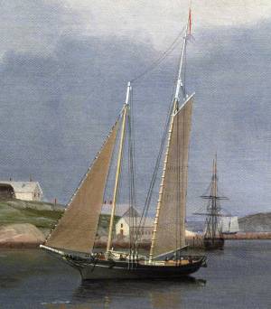
Schooners in Lane’s time were, with few exceptions, two-masted vessels carrying a fore-and-aft rig having one or two jibs, a fore staysail, gaff-rigged fore- and main sails, and often fore- and main topsails. One variant was the topsail schooner, which set a square topsail on the fore topmast. The hulls of both types were basically similar, their rigs having been chosen for sailing close to the wind. This was an advantage in the coastal trade, where entering confined ports required sailing into the wind and frequent tacking. The square topsail proved useful on longer coastwise voyages, the topsail providing a steadier motion in offshore swells, reducing wear and tear on canvas from the slatting of the fore-and-aft sails. (1)
Schooners of the types portrayed by Lane varied in size from 70 to 100 feet on deck. Their weight was never determined, and the term “tonnage” was a figure derived from a formula which assigned an approximation of hull volume for purposes of imposing duties (port taxes) oncargoes and other official levies. (2)
Crews of smaller schooners numbered three or four men. Larger schooners might carry four to six if a lengthy voyage was planned. The relative simplicity of the rig made sail handling much easier than on a square-rigged vessel. Schooner captains often owned shares in their vessels, but most schooners were majority-owned by land-based firms or by individuals who had the time and business connections to manage the tasks of acquiring and distributing the goods to be carried. (3)
Many schooners were informally “classified” by the nature of their work or the cargoes they carried, the terminology coined by their owners, agents, and crews—even sometimes by casual bystanders. In Lane’s lifetime, the following terms were commonly used for the schooner types he portrayed:
Fishing Schooners: While the port of Gloucester is synonymous with fishing and the schooner rig, Lane depicted only a few examples of fishing schooners in a Gloucester setting. Lane’s early years coincided with the preeminence of Gloucester’s foreign trade, which dominated the harbor while fishing was carried on from other Cape Ann communities under far less prosperous conditions than later. Only by the early 1850s was there a re-ascendency of the fishing industry in Gloucester Harbor, documented in a few of Lane’s paintings and lithographs. Depictions of fishing schooners at sea and at work are likewise few. Only A Smart Blow, c.1856 (inv. 9), showing cod fishing on Georges Bank (4), and At the Fishing Grounds, 1851 (inv. 276), showing mackerel jigging on Georges Bank, are known examples. (5)
– Erik Ronnberg
References:
1. Howard I. Chapelle, The History of American Sailing Ships (New York: W.W. Norton & Co., 1935), 258. While three-masted schooners were in use in Lane’s time, none have appeared in his surviving work; and Charles S. Morgan, “New England Coasting Schooners”, The American Neptune 23, no. 1 (DATE): 5–9, from an article which deals mostly with later and larger schooner types.
2. John Lyman, “Register Tonnage and its Measurement”, The American Neptune V, nos. 3–4 (DATE). American tonnage laws in force in Lane’s lifetime are discussed in no. 3, pp. 226–27 and no. 4, p. 322.
3. Ship Registers of the District of Gloucester, Massachusetts, 1789–1875 (Salem, MA: The Essex Institute, 1944). Vessels whose shipping or fishing voyages included visits to foreign ports were required to register with the Federal Customs agent at their home port. While the vessel’s trade or work was unrecorded, their owners and master were listed, in addition to registry dimensions and place where built. Records kept by the National Archives can be consulted for information on specific voyages and ports visited.
4. Howard I. Chapelle, The National Watercraft Collection (Washington, DC: Smithsonian Institution, 1960), 74–76.
5. Howard I. Chapelle, The American Fishing Schooners (New York: W.W. Norton & Co., 1973), 58–75, 76–101.
1852
Oil on canvas
28 x 48 1/2 in.
Cape Ann Museum, Gloucester, Mass., Deposited by the City of Gloucester, 1952. Given to the city by Mrs. Julian James in memory of her grandfather Sidney Mason, 1913 (DEP. 200)
Detail of fishing schooner.
Also filed under: Gloucester Harbor, Inner / Harbor Cove »
c.1865 Stereograph card Frank Rowell, Publisher stereo image, "x " on card, "x" Cape Ann Museum Library & Archive
View showing a sharpshooter fishing schooner, circa 1850. Note the stern davits for a yawl boat, which is being towed astern in this view.
Also filed under: Historic Photographs »
Model made for marine artist Thomas M. Hoyne
scale: 3/8" = 1'
Thomas M. Hoyne Collection, Mystic Seaport, Conn.
While this model was built to represent a typical Marblehead fishing schooner of the early nineteenth century, it has the basic characteristics of other banks fishing schooners of that region and period: a sharper bow below the waterline and a generally more sea-kindly hull form, a high quarter deck, and a yawl-boat on stern davits.
The simple schooner rig could be fitted with a fore topmast and square topsail for making winter trading voyages to the West Indies. The yawl boat was often put ashore and a "moses boat" shipped on the stern davits for bringing barrels of rum and molasses from a beach to the schooner.
– Erik Ronnberg
References:
Jeffrey Bolster, Black Jacks: African American Seafarers in the Age of Sail (Cambridge, MA: Harvard University Press, 1997).
Howard I. Chapelle, American Small Sailing Craft (New York: W.W. Norton & Co., 1951), 29–31.
Also filed under: Hand-lining » // Ship Models »

20 x 14 in.
Cape Ann Museum Library & Archive, Gloucester, Mass.
The image, as originally drafted, showed only spars and sail outlines with dimensions, and an approximate deck line. The hull is a complete overdrawing, in fine pencil lines with varied shading, all agreeing closely with Lane's drawing style and depiction of water. Fishing schooners very similar to this one can be seen in his painting /entry:240/.
– Erik Ronnberg
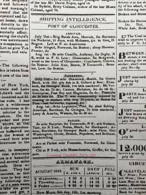
Newspaper
"Shipping Intelligence: Port of Gloucester"
"Fishermen . . . The T. [Tasso] was considerably injured by coming in contact with brig Deposite, at Salem . . ."
Also filed under: Newspaper / Journal Articles »
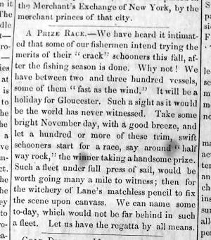
Newsprint
From bound volume owned by publisher Francis Procter
Collection of Fred and Stephanie Buck
"A Prize Race—We have heard it intimated that some of our fishermen intend trying the merits of their "crack" schooners this fall, after the fishing season is done. Why not! . . .Such a fleet under full press of sail, would be worth going many a mile to witness; then for the witchery of Lane's matchless pencil to fix the scene upon canvass. . ."
Also filed under: Fishing » // Newspaper / Journal Articles »
Also filed under: Cape Ann Advertiser Masthead »
c.1870 Stereograph card Procter Brothers, Publisher Cape Ann Museum Library & Archive
"Gloucester Harbor from Rocky Neck, Looking Southwest. This gives a portion of the Harbor lying between Ten Pound Island and Eastern Point. At the time of taking this picture the wind was from the northeast, and a large fleet of fishing and other vessels were in the harbor. In the range of the picture about one hundred vessels were at anchor. In the small Cove in the foreground quite a number of dories are moored. Eastern Point appears on the left in the background."
Southeast Harbor was known for being a safe harbor.
Also filed under: Gloucester Harbor, Outer » // Historic Photographs » // Rocky Neck » // Small Craft – Wherries, and Dories »
1870s Stereograph card Cape Ann Museum Library & Archive
"Said schooner was captured about the first of September, 1871, by Capt. Torry, of the Dominion Cutter 'Sweepstakes,' for alleged violation of the Fishery Treaty. She was gallantly recaptured from the harbor of Guysboro, N.S., by Capt. Harvey Knowlton., Jr., (one of her owners,) assisted by six brave seamen, on Sunday night, Oct. 8th. The Dominion Government never asked for her return, and the United States Government very readily granted her a new set of papers."
Also filed under: Fishing » // Historic Photographs » // Waterfront, Gloucester »
1876 Photograph Cape Ann Museum Library & Archive
Also filed under: Gloucester Harbor, Inner / Harbor Cove » // Historic Photographs » // Waterfront, Gloucester »

c.1870 Cape Ann Museum Library & Archive (2013.068)
Schooner fleet anchored in the inner harbor. Looking east from Rocky Neck, Duncan's Point wharves and Lane house (at far left), Sawyer School cupola on Friend Street.
Also filed under: Duncan's Point » // Gloucester Harbor, Inner / Harbor Cove » // Historic Photographs » // Waterfront, Gloucester »
See p. 254.
As Erik Ronnberg has noted, Lane's engraving follows closely the French publication, Jal's "Glossaire Nautique" of 1848.
Also filed under: Babson History of the Town of Gloucester »
Wood, cordage, acrylic paste, metal
~40 in. x 30 in.
Erik Ronnberg
Model shows mast of fishing vessel being unstepped.
Also filed under: Burnham Brothers Marine Railway » // Fishing »

Watercolor on paper
8 3/4 x 19 3/4 in.
Cape Ann Museum, Gloucester, Mass., Gift of Rev. and Mrs. A. A. Madsen, 1950
Accession # 1468
Fishing schooners in Gloucester's outer harbor, probably riding out bad weather.
Also filed under: Elwell, D. Jerome » // Gloucester Harbor, Outer »

1876 Photograph Cape Ann Museum Library & Archive
Ignatius Weber's windmill (now defunct) is shown.
Also filed under: Flake Yard » // Fort (The) and Fort Point » // Gloucester Harbor, Inner / Harbor Cove » // Historic Photographs » // Rogers's (George H.) wharves » // Waterfront, Gloucester » // Windmill »
Print from bound volume of Gloucester scenes sent to the Philadelphia Centennial Exhibition.
11 x 14 in.
Cape Ann Museum Library & Archives
Schooner "Grace L. Fears" at David A. Story Yard in Vincent's Cove.
Also filed under: Historic Photographs » // Shipbuilding / Repair » // Vincent's Cove »
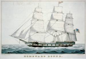
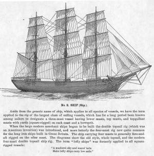
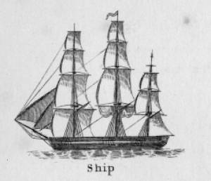
The term "ship," as used by nineteenth-century merchants and seamen, referred to a large three-masted sailing vessel which was square-rigged on all three masts. (1) In that same period, sailing warships of the largest classes were also called ships, or more formally, ships of the line, their size qualifying them to engage the enemy in a line of battle. (2) In the second half of the nineteenth century, as sailing vessels were replaced by engine-powered vessels, the term ship was applied to any large vessel, regardless of propulsion or use. (3)
Ships were often further defined by their specialized uses or modifications, clipper ships and packet ships being the most noted examples. Built for speed, clipper ships were employed in carrying high-value or perishable goods over long distances. (4) Lane painted formal portraits of clipper ships for their owners, as well as generic examples for his port paintings. (5)
Packet ships were designed for carrying capacity which required some sacrifice in speed while still being able to make scheduled passages within a reasonable time frame between regular destinations. In the packet trade with European ports, mail, passengers, and bulk cargos such as cotton, textiles, and farm produce made the eastward passages. Mail, passengers (usually in much larger numbers), and finished wares were the usual cargos for return trips. (6) Lane depicted these vessels in portraits for their owners, and in his port scenes of Boston and New York Harbors.
Ships in specific trades were often identified by their cargos: salt ships which brought salt to Gloucester for curing dried fish; tea clippers in the China Trade; coffee ships in the West Indies and South American trades, and cotton ships bringing cotton to mills in New England or to European ports. Some trades were identified by the special destination of a ship’s regular voyages; hence Gloucester vessels in the trade with Surinam were identified as Surinam ships (or barks, or brigs, depending on their rigs). In Lane’s Gloucester Harbor scenes, there are likely (though not identifiable) examples of Surinam ships, but only the ship "California" in his depiction of the Burnham marine railway in Gloucester (see Three Master on the Gloucester Railways, 1857 (inv. 29)) is so identified. (7)
– Erik Ronnberg
References:
1. R[ichard)] H[enry] Dana, Jr., The Seaman’s Friend, 13th ed. (Boston: Thomas Groom & Co., 1873), p. 121 and Plate IV with captions.
2. A Naval Encyclopaedia (Philadelphia: L. R. Hamersly & Co., 1884), 739, 741.
3. M.H. Parry, et al., Aak to Zumbra: A Dictionary of the World’s Watercraft (Newport News, VA: The Mariners’ Museum, 2000), 536.
4. Howard I. Chapelle, The History of American Sailing Ships (New York: W.W. Norton & Co., 1935), 281–87.
5. Ibid.
6. Howard I. Chapelle, The National Watercraft Collection (Washington, DC: Smithsonian Institution, 1960), 26–30.
7. Alfred Mansfield Brooks, Gloucester Recollected: A Familiar History (Gloucester, MA: Peter Smith, 1974), 67–69.
Photograph
From American Clipper Ships 1833–1858, by Octavius T. Howe and Frederick C. Matthews, vol. 1 (Salem, MA: Marine Research Society, 1926).
Photo caption reads: "'Golden State' 1363 tons, built at New York, in 1852. From a photograph showing her in dock at Quebec in 1884."
Also filed under: "Golden State" (Clipper Ship) »
_sm.jpg)

Oil on canvas
24 x 35 in.
Peabody Essex Museum, Salem, Mass.
Walters' painting depicts the "Nonantum" homeward bound for Boston from Liverpool in 1842. The paddle-steamer is one of the four Clyde-built Britannia-class vessels, of which one is visible crossing in the opposite direction.
View related catalogue entries (2) »
Also filed under: Packet Shipping » // Walters, Samuel »
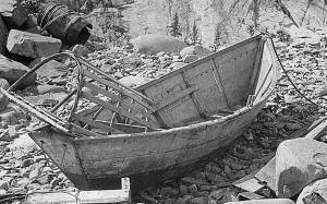
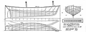
The term “wherry”—variously spelled—has a long history with many hull types, some dating from the fifteenth century. (1) The version known to Lane appears to be a variant of the dory hull form and probably was developed by French and English fishermen in the Newfoundland fisheries before 1700. (2) From that time, the wherry and the dory co-evolved, their similarities the result of their construction, their differences the result of use. By the early nineteenth century, their forms reached their final states, if fragments of contemporary descriptions are any indication. (3)
By the time Lane was depicting wherries, the type (as used for fishing) resembled a larger, wider version of a dory. The extra width was due to greater bottom width (both types had flat bottoms), with a wider transom at the stern instead of the narrow, v-shaped “tombstone.” These features are easy to see in one of his drawings (see Three Men, One in a Wherry, n.d. (inv. 225)) and a painting (see Sunrise through Mist, 1852 (inv. 98)), the latter depicted alongside a dory, clearly showing the differences.
No published descriptions of the uses of wherries on Cape Ann in Lane’s time have come to light, but an example in broadside view offers one use. In Becalmed Off Halfway Rock, 1860 (inv. 344), a pinky (in right foreground) has a dory and a wherry in tow, the latter loaded with a gill net for catching mackerel. (4) The greater size of the wherry is required for stowing the net, as well as setting it while the dory tows away one end to set it in way of the mackerel school.
In Lane’s time, wherries would have been used where bulky gear was called for in the coastal fisheries, i.e. gill nets, and fish traps such as pound nets, fyke nets, and lobster traps. Migrating fish schools (herring, mackerel) and shellfish were the target species.
The dory’s development was first dictated by its use in shore fishing, where small size and light weight made it easy to maneuver around rocks and shallows, and to haul ashore at the end of a day’s work. Its simple design made it easy and cheap to build. This is borne out by the standardized construction and sizes used by Simon Lowell’s boat shop at Salisbury Point, Massachusetts at the turn of the nineteenth century. Lowell called his boats “wherries,” but in Swampscott, Massachusetts, the fishermen, who used them called them “dories,” which may mark the beginning of the latter term’s wider use. (5)
The dories we see in Lane’s paintings are in virtually every way like the ones we know today. One of the best examples (see View from Kettle Cove, Manchester-by-the-Sea, 1847 (inv. 94)) even shows interior detail, including frames, leaving no doubt about its construction. Other good examples are found in Salem Harbor, 1853 (inv. 53), View of Gloucester Harbor, 1848 (inv. 97), and Sunrise through Mist, 1852 (inv. 98).
For inshore fishing, dories were used to catch mackerel and herring, either with hook and line or with small nets. Hooks and line were used for flat fish (flounder, dab, and fluke), rock cod, hake, and cunner. Eels were speared (see View from Kettle Cove, Manchester-by-the-Sea, 1847 (inv. 94)), clams were dug, and lobsters trapped. In Lane’s later years, the use of dories in trawling (setting long “trawl lines” with many baited hooks) was in its earliest. This method required six to ten dories carried on board a schooner to fish on the distant banks off New England and Canada. Early records of dory trawling in New England are fragmentary, giving the mid-1840s as the time of introduction. (6) The Gloucester-owned schooner "Anna" made a successful dory trawling trip to the Grand Banks in 1854, but no depiction of this vessel by Lane has been found or recorded. (5) Despite successful early efforts, dory trawling from Gloucester was slow to be accepted, and the fishery had very limited growth prior to 1860. (7)
– Erik Ronnberg
References:
1. M.H. Parry et al., Aak to Zumbra (Newport News, VA: The Mariners’ Museum, 2000), 634.
2. John Gardner, The Dory Book (Camden, ME: International Marine Publishing Company, 1978), 5–9.
3. Ibid., 25–29.
4. John Wilmerding, ed., Paintings by Fitz Hugh Lane (Washington, DC: National Gallery of Art, 1988), 89, 92. The “possibly discarded whaleboat” is definitely a wherry.
5. Gardner, 9, 10.
6. Wesley George Pierce, Goin’ Fishin’ (Salem, MA: Marine Research Society, 1934), 63–64.
7. Raymond McFarland, A History of New England Fisheries (Philadelphia: University of Pennsylvania, 1911), 279.
c.1870 Stereograph card Procter Brothers, Publisher Cape Ann Museum Library & Archive
"Gloucester Harbor from Rocky Neck, Looking Southwest. This gives a portion of the Harbor lying between Ten Pound Island and Eastern Point. At the time of taking this picture the wind was from the northeast, and a large fleet of fishing and other vessels were in the harbor. In the range of the picture about one hundred vessels were at anchor. In the small Cove in the foreground quite a number of dories are moored. Eastern Point appears on the left in the background."
Southeast Harbor was known for being a safe harbor.
Also filed under: Gloucester Harbor, Outer » // Historic Photographs » // Rocky Neck » // Schooner (Fishing) »
Also filed under: Chebacco Boat / Dogbody / Pinky » // Ship Models »
Gloucester, MA
4 x 33 1/2 x 7 1/4 in (10.16 x 85.09 x 18.415 cm)
Peabody Essex Museum
Also filed under: Objects » // Ship Models »
The Eastern Point Light is located in the town of Gloucester, Massachusetts on the east side of the entrance to Gloucester Harbor. In 1829, an unlit stone beacon was erected on Eastern Point to help mariners navigating Gloucester Harbor. Shortly thereafter, in 1832, a wrought-iron and copper lantern was added to the stone tower, and the first Eastern Point Light was born. During the 1840s, Gloucester became one of the most important fishing ports in America, and to cope with the increased fishing traffic, a new Eastern Point Light was built in 1848. The new 34 foot tower gained the nickname "The Ruby Light" due to its unique fixed red light. The Eastern Point Light was further improved upon in the following decades with the addition of a fourth-order Fresnel lens and fog bell.
This information has been shared with the Lane project by Jeremy D'Entremont. More information can be found at his website, www.newenglandlighthouses.net or in The Lighthouse Handbook New England. This information has also been summarized from Paul St. Germain's book, Lighthouses and Lifesaving Stations on Cape Ann.
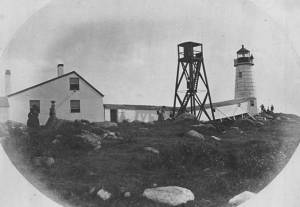
Photograph U.S. Coastguard
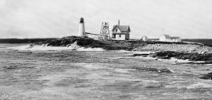
For over 100 years the fishermen of Gloucester have been guided back to their home port by a lighthouse on Eastern Point. The present brick tower, painted a gleaming white, and standing on the long rocky point forming the eastern side of the harbor, was built in 1890, replacing on the same foundation the original tower built in 1832. Before 1832 a still older lighthouse, on Ten-Pound Island well inside of the harbor, had served as an entrance light, but this light was never visible until ships had actually found the entrance, hence the building of a lighthouse on the Eastern Point where it could be seen from far offshore.
Courtesy United States Coast Guard.
Also filed under: Historic Photographs »
Newspaper
"There are quite a number of visitors in town at the present time, who come to spend a few weeks by the seaside, during the sultry weather of August."
Also filed under: Fessenden, C. B. » // Newspaper / Journal Articles » // Procter Brothers – Gloucester, Mass. » // Tourist Industry »
Newspaper clipping
Cape Ann Advertiser
Collection of Fred and Stephanie Buck
"MARINE PAINTING. – F. H. Lane, Esq., has recently completed a picture for Dr. H. E. Davidson of this town. The painting represents a sunset scene in our harbor, which is taken near the cut bridge, introducing the beach covered with rocks and pebbles, steep bank, and Stage Fort, with the surrounding scenery in the vicinity. . . It is impossible to give an adequate idea of this painting by any description of ours, for it must be seen to be appreciated. It is the largest painting the artist has yet finished, and, in our opinion, his best. The painting is now on exhibition at the Studio, for a short time, where those who are interested in works of art can have an opportunity of viewing it."
Also filed under: Davidson, Dr. Herman Elvas » // Newspaper / Journal Articles » // Studio Descriptions »
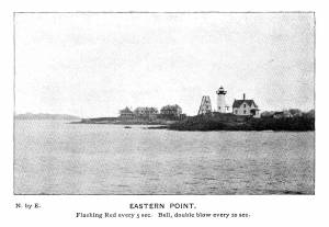
Plate from The Illustrated Coast Pilot with Sailing Directions: The Coast of New England from New York to Eastport, Maine including Bays and Harbors, published by N. L. Stebbins,1896.
Also filed under: Eastern Point »
Stereograph card
Published by Frank Rowell
Cape Ann Museum Library & Archive
Also filed under: Eastern Point »
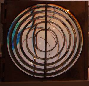
Four circular glass prism lenses in a brass frame:
Lens diameters 19". Base 21" square x 19-1/2" high.
Cape Ann Museum. On permanent loan from the United States Coast Guard, 2013
When installed, the light source was fixed and the lens mount rotated.
Also filed under: Objects »
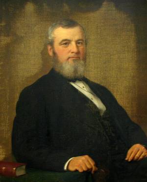
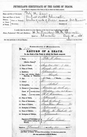
Dr. Davidson (1815–90) was a close friend of Lane and his personal physician in Gloucester. He signed Lane’s death certificate. He and his wife received equal portions of Lane’s five-hundred-dollar legacy, and Dr. Davidson inherited Lane’s gold watch and chain.
The Davidsons lived in Gloucester from 1842 until 1878, and for most of that time inhabited the old Sanders house, now the Sawyer Free Library. Dr. and Mrs. Davidson were relatively wealthy, owning shares of gas, steamboat and railroad companies, “machinery used in manufacturing establishments,” a horse, a chaise, a large house with barn, an acre of land and two- to three-thousand-dollar “cash assets.” (1) Their land lay to the north of Middle Street along Mason Street, including what is now occupied by the Central Grammar apartments (the old high school). (2)
The house had been Beach’s house, with the rope walk behind, but Phebe Wilson Davidson (Dr. Herman’s mother) bought it from the Eastern Railroad Company on February 19, 1850. (3) It was bequeathed to Herman E. Davidson by Phebe’s will, dated November 12, 1859. This elegant house and the gardens were drastically disrupted by the laying out of Dale Avenue in 1866, a year after Lane’s death, and the anguished doctor sued the Town.
The Davidsons also had an unwanted ring-side seat for the 1866 construction, the 1869 fiery destruction, and the 1871 reconstruction of the Town Hall on that newly laid-out Dale Avenue. Dr. Joseph Garland wrote of his older contemporary: "Dr. Davidson, was a thoroughly educated physician. He was of studious habits and deeply interested in scholarly pursuits. He was a skilled physician of the modern school of medicine, and never believed in crowding drugs into his patients. His practice was expectant—watching and waiting upon nature, and ever ready to assist her efforts in repelling or subduing disease. He soon acquired a good practice and secured the confidence of the community."
Edward Henry Lane wrote: “… Dr. Davidson … was one of his [uncle Lane’s] closest friends, and almost every Sunday, weather permitting, would find them together at the Doctor’s home.” (4) It was to the Davidson house that Lane fled and sought refuge during the time of unpleasantness with Ignatius Winter. It was in their upper bedroom that Lane slept and dreamt the famous dream of the painting on the wall. And it was to his hostess, Sarah M. Davidson, that Lane gave the sketch of this Dream Painting. Dr. Davidson was the first president of the Cape Ann Scientific & Literary Association, the predecessor to the Cape Ann Historical Association.
On August 9, 1859, Dr. Herman Davidson was married to Mrs. Sarah M. (Bowker) Chamberlain in Boston by Gloucester’s Universalist minister, Rev. W. R. G. Mellen, who was Mary Mellen’s brother-in-law. Herman was forty-four and Sarah was thirty-two. (5) They continued to live in Gloucester until 1878—having traveled abroad from 1872 to 1875—when he left on account of his wife’s health, to reside in the milder climates of this country. She died at Washington, D.C. on May 16, 1880. After traveling abroad for several years he died at Northeast Harbor, Mount Desert, Maine, in 1890.
Among the many inventions devised by the doctor was the Davidson Bulb Syringe now universally in use, and a meat press "that anyone can use to press all the juice from the beef into a dish for the use of invalids." (6) Still another invention was called “Davidson’s Method in Ichthytaxidermy” or the mounting of fish for use in the study of Natural History.
In Gloucester, Davidson was a member of the school committee for several years, the first President of the Cape Ann Scientific & Literary Association, Vice President of the Cape Ann Horticultural Society, one of the Corporators of Oak Grove Cemetery, and a member of the Board of Trustees until his departure from the City.
Dr. Davidson was buried in Oak Grove Cemetery, not far from the Stevens plot and the grave of Fitz Henry Lane. (7) His and his wife Sarah’s remains were removed to the more outlying plot #283 on Jasmine Lane in 1947, when his original gravesite was sold back to the Oak Grove Cemetery by his daughter Alice Davidson Tilton. (8) The bronze plaque on the large boulder at plot #283 reads: Hamilton Davidson 1787–1848; Phebe Davidson 1785–1858; Herman E. Davidson M.D. 1815–90; Charles H. Davidson 1812–60; Mary Jane Davidson 1820–36; Eliza Ann Delano 1817–53.
Alice Davidson Tilton gave View of Coffin's Beach, 1862 (inv. 41) to the Cape Ann Museum.
– Stephanie Buck (March, 2015)
(1) Assessor’s Valuations, Harbor Parish East Ward, 1862-64. Gloucester Archives, CC223.
(2) D. G. Beers & Co., Map of the Built up Portion of the Town of Gloucester, Mass. 1872. Cape Ann Museum.
(3) Essex County, Salem, Registry of Deeds, Bk. 436, 293; and Bk. 563, 19.
(4) Edward H. Lane, Cape Ann Scientific & Literary Association. Weekly Column on Matters of Local History, Gloucester Daily Times, March 23, 1916.
(5) Massachusetts Vital Records, Marriages, Boston, vol. 128, 77.
(6) An unpublished obituary by Rhodes Lockwood, handwritten manuscript from the Authors and Artists of Cape Ann, Cape Ann Historical Association Scrapbook #86, as in Sarah Dunlap and Stephanie Buck. Fitz Henry Lane: Family and Friends. (Gloucester, MA: Church & Mason Publishing; in association with the Cape Ann Historical Museum, 2007), 85.
(7) Plot #452, Hickory Avenue, Section 7.
(8) Oak Grove records, Gloucester Archives.
Newspaper clipping
Cape Ann Advertiser
Collection of Fred and Stephanie Buck
"MARINE PAINTING. – F. H. Lane, Esq., has recently completed a picture for Dr. H. E. Davidson of this town. The painting represents a sunset scene in our harbor, which is taken near the cut bridge, introducing the beach covered with rocks and pebbles, steep bank, and Stage Fort, with the surrounding scenery in the vicinity. . . It is impossible to give an adequate idea of this painting by any description of ours, for it must be seen to be appreciated. It is the largest painting the artist has yet finished, and, in our opinion, his best. The painting is now on exhibition at the Studio, for a short time, where those who are interested in works of art can have an opportunity of viewing it."
Also filed under: Gloucester, Mass. – Eastern Point Light » // Newspaper / Journal Articles » // Studio Descriptions »
Newspaper clipping
Cape Ann Advertiser
Collection of Fred and Stephanie Buck
"MARINE PAINTING. – Mr. F. H. Lane has recently finished a splendid painting of Coffin's Beach, taken from the 'Loaf', which is one of the artist's happiest efforts. In the foreground is represented a ledge of cragged rocks over which the sea is tumbling in feathery foam; while stretching away to the right is the long sand beach and open bay. In the distance are seen the villages of Annisquam and Lanesville. The sun is just rising behind the hills, throwing his golden beams over the whole scene, forming a picture truly delightful to gaze upon. There is an air of solitary grandeur about the painting which we have seldom seen equalled, and we hope the artist will be induced to place it on exhibition for a few days."
View related catalogue entries (2) »
Also filed under: Coffin's Beach » // Newspaper / Journal Articles » // Studio Descriptions »
Newspaper clipping
Cape Ann Advertiser
Collection of Fred and Stephanie Buck
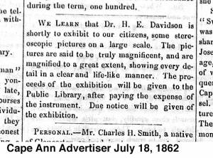
"We learn that Dr. H.E. Davidson is shortly to exhibit to our citizens, some stereoscopic pictures on a large scale. The pictures are said to be truly magnificent, and are magnified to a great extent, showing every detail in a clear and life-like manner. The proceeds of the exhibition will be given to the Public Library, after paying the expense of the instrument. Due notice will be given of the the exhibition."
Also filed under: Newspaper / Journal Articles » // Sawyer Free Library »
Also filed under: Biographical information » // Funeral & Burial »
1862 Letter Terra Foundation for American Art, Chicago
A letter affixed to the verso of Lane's Dream Painting of 1862 in which he describes how the idea for the painting came to him in a dream. Lane writes: "This picture, the Property of John S. Webber Esq, Collector of the Port and District of Gloucester, was (suggested) to the artist by a dream. Sometime last fall while asleep in bed, a richly furnished room was presented to my imagination. Upon the wall my attention was attracted to a picture which I have here endeavored to reproduce. The dream was very vivid and on awakening I retained it in memory for a long time. The effect was so beautiful in the dream that I determined to attempt its reproduction, and this picture is the result. The drawing is very correct, but the effect falls far short of what I saw, and it would be impossible to convey to canvas such gorgeous and brilliant colouring as was presented to me. This picture, however, will give to the beholder some faint idea of the ideal. /signed/ Fitz H. Lane."
Also filed under: Chronology » // Letters » // Letters / Manuscripts » // Signature / Name change » // Webber, John Somes »
October 3, 1865 Essex County Probate Records, Volume 424, Leaves 34 & 35
The will disposed of Lane's property (including watch and diamond breast pin), his monetary assets, and gave to the city of Gloucester a painting of the Old Fort. Joseph Stevens, Jr. and T. Sewall Lancaster were named executors. It was signed by Lane on March 10, 1865.
Also filed under: Chronology » // Documents / Objects » // Funeral & Burial » // Galacar, Elizabeth » // Lancaster, T. Sewall » // Mellen, Mary Blood » // Page, Eben » // Stevens, Caroline Foster » // Stevens, Joseph, Jr. » // Wilbur, Horace B. »
Mrs. H. E. Davidson was a close friend of Lane's and the wife of his personal physician in Gloucester. Lane made several paintings from drawings for her, including the famous Dream Painting, 1862 (inv. 74).
Mrs. H. E. Davidson was Sarah M. (Bowker) Chamberlain (1827–80), and the wife of Dr. Herman E. Davidson (1815–90). She was born as Sally Morse Bowker, daughter of James and Izanna Bowker in Hopkinton, MA, April 29, 1827. (1) She married John Henry Chamberlain, merchant, in 1847 when she was twenty and he was thirty. (2) He died the following year in the Fiji Islands. She and Dr. Herman E. Davidson were married in Boston in 1859 by Mary Mellen’s brother-in-law and Gloucester’s Universalist minister, Rev. W. R. G. Mellen. Herman was forty-four and she was thirty-two. (3)
Mrs. Davidson joined her husband in his Gloucester home, the old Sanders house, now the Sawyer Free Library, and had two daughters, Alice Bowker Davidson, born in 1860 and Edith Bowker Davidson, born in 1862. The Davidsons were relatively wealthy, owning shares of gas, steamboat, and railroad companies, a horse, a chaise, a large house with barn, an acre of land, and two-to-three thousand dollars in "cash assets.”(4)
Fitz H. Lane gave Mrs. Davidson the sketch of his Dream Painting that he made during his sojourn at the Davidson’s after his altercation with his brother-in-law, and she and her husband were left equal portions of Lane’s five-hundred-dollar legacy in his will.
Mrs. Davidson was ill for several years before her death, during which time she and her husband traveled in Europe and around America seeking a more congenial climate for her. She died of consumption in Washington, D.C. on May 16, 1880, and was buried in Oak Grove Cemetery in Gloucester, Massachusetts. (5)
– Stephanie Buck
(1) Massachusetts Vital Records, Births, Hopkinton. US Vital Records.org
(2) Massachusetts Vital Records, Marriages, Hopkinton, Vol. 31, 27.
(3) Massachusetts Vital Records, Marriages, Boston, Vol. 128, 77.
(4) Assessor’s Valuations, Harbor Parish East Ward, 1862-64. Gloucester Archives, CC223.
(5) Gloucester Deaths, Bk. 10, 80.