An online project under the direction of the CAPE ANN MUSEUM
Catalogue Entry
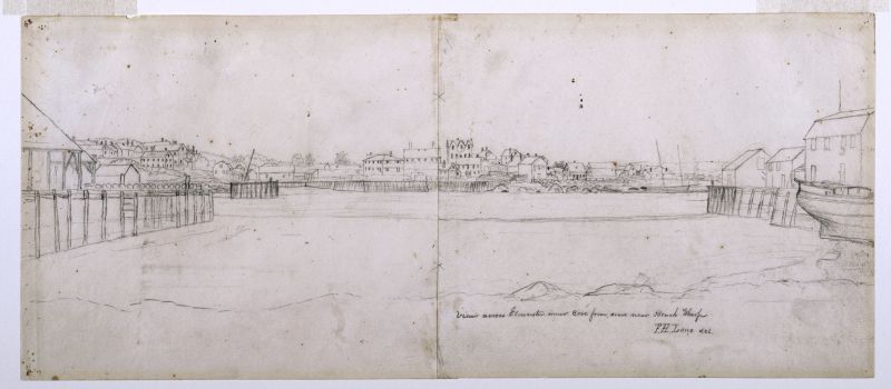
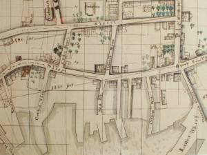
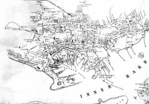
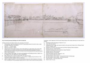
This drawing and View in Gloucester Harbor, 1850s (inv. 143) show mirror views of Gloucester's busy Inner Harbor. Lined with wharves, the sheltered cove (the Inner Harbor was also known as Harbor Cove) was valuable real estate for Gloucester's merchants. In this drawing, the view is from the shoreline of Fort Point looking towards Duncan's Neck. Duncan's Neck was a curved bit of land, much of which was owned by Frederick Low. Lane's stone house, on land he purchased in 1849, can be seen at the top of the hill with its three pointed gables.
The shoreline of Fort Point, from which the drawing was sketched, is near (or perhaps on) the Town Landing, and near one of George Rogers's wharves. The development of these wharves is well documented by Erik Ronnberg. Behind the viewer were the flake yards, and at the end projecting into the Harbor was the Fort. The drawing shows the wharves, with buildings lining them, and the graving beach (used for the cleaning of ships' hulls) once located along what is now Commercial Street. At high tide, vessels would be run aground on the beach. When the tide receded, leaving a boat grounded in the sand, repairs could be easily made to its hull and rigging.
Lane’s drawing of Harbor Cove from the graving beach on its southwest shore line, looking northeast, is unique among his depictions of this harbor—all the more so as no derivative painting (or published description thereof) has been found to date. It is also notable for including the artist’s new house at the drawing’s visual center with the wharves of I.J. Procter and John W. Lowe pointing insistently in its direction.
Few other works by Lane contain a view of his house. In Gloucester Harbor, 1856 (inv. 75) and its drawing, Gloucester from Fresh Water Cove, 1850s (inv. 144), the three gables of its south west side can be seen peeking over Fort Point, just to the left of the old Fort’s remains. The house can also be seen—with difficulty—in his 1859 lithograph of the Inner Harbor (View of Gloucester, 1859 (inv. 446); a hand-colored print, View of Gloucester, 1859 (inv. 91), shows the gabled roof more distinctly. This drawing provides the only view of the house that is nearly unobstructed (part of the first floor, below window level, is obscured by the house of Fitz E. Riggs.)
The location of Lane’s new residence and studio is significant in several ways. Harbor Cove was no longer a place to be visited and depicted on occasion; it was now his neighborhood, with several previous clients as his new neighbors, whom he would see on a daily basis. It also placed him in the heart of Gloucester, which would have made his involvement in civic activities and celebrations more accessible and conspicuous. (1)
This drawing could have been made as early as 1850, assuming the exterior construction and roof work were complete. The building was occupied in 1851, first by Ignatius Winter and his family, and later in that year by Lane. (2) The absence of one detail in the drawing argues against a date later than 1853, namely the absence of a smoke stack (then under construction) for the steam engine to operate the hauling winch and the mill saw at Burnham Brothers’ marine railway. Were it present, Lane certainly could not have ignored what was to be a significant landmark in his later depictions of this area. (3)
While the house’s location gave it scenic prominence, it is likely that Lane valued it chiefly for the view of Gloucester Harbor and its skyline which he could study from the comfort and convenience of his studio at all hours and in any weather. It is after he moved there that his paintings show greater development of color, mood, subtlety, and drama in cloud formations, Similarly, his sunsets became more intense and serene. (4) Working outdoors only in pencil forced him to paint such effects from memory in his studio which, if it had only limited visual access to the sky, would have been a hindrance. In his new studio, he could study and capture cloud formations and atmospheric colors, lending drama or serenity to a scene as he seldom had before.
– Erik Ronnberg
References:
1. Dunlap, Sarah and Stephanie Buck, Fitz Henry Lane: Family and Friends (Gloucester, MA: Church & Mason Publishing and Cape Ann Museum, 2007), pp. 53-57.
2. Ibid., p. 64.
3. Gloucester City Archives, Valuations for Harbor Parish, East Ward, 1851, 1852, 1853, 1854.
Valuations for wharf facilities and railway, 1851: $3,280; 1852: $4,800; 1853: $6,000; 1854: $9,000.
This steady and substantial growth is hard to explain in any other way than in the form of mechanical improvements, including steam-powered machinery to operate the hauling winch and power saws for a mill building for shipbuilding timber and planking. A note in the 1853 valuation, simply stating “new railway”, probably refers to the addition of a second railway, which would account for the significantly higher valuation in 1854.
4. On cloud formations: as in Gloucester Harbor, 1852 (inv. 38), Brig Off the Maine Coast, 1851 (inv. 241), Boston Harbor, 1854 (inv. 341), and Clipper Ship "Southern Cross" in Boston Harbor, 1851 (inv. 253). Sunsets: as in Norman's Woe, Gloucester Harbor, 1862 (inv. 1), View of Camden Mountains from Penobscot Bay, c.1852 (inv. 207), Lumber Schooners at Evening on Penobscot Bay, 1863 (inv. 343), and Becalmed Off Halfway Rock, 1860 (inv. 344).
Key to the Drawing
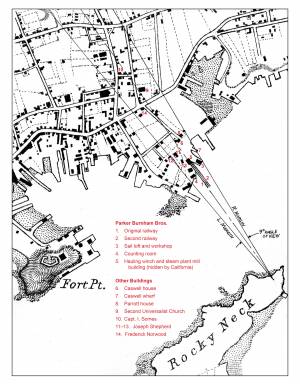
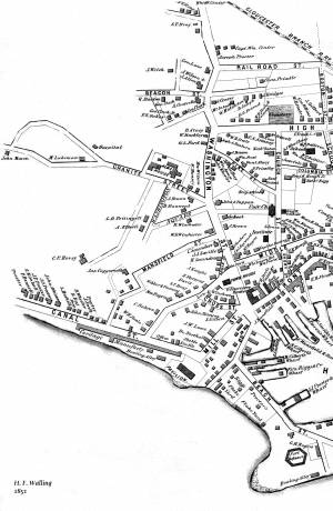
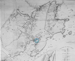
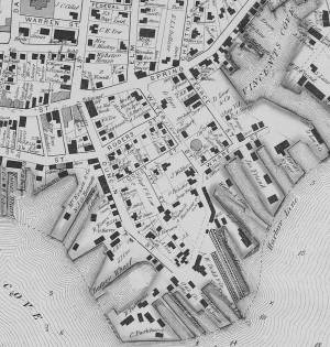
This key is based on two contemporaneous maps of Gloucester Harbor: (1) Henry Francis Walling, “Map of the towns of Gloucester and Rockport, Essex Co. Massachusetts” (Philadelphia: A. Kollner, 1851) and (2) A. D. Bache, Superintendent, “Preliminary Chart of Gloucester Harbor, Massachusetts” (Washington, DC: Survey of the Coast of the United States, 1854). There are differences between these two sources, the locations and sizes of buildings in the Walling map being closer to Lane’s depictions, while the Coast Survey chart appears to show the shoreline and wharf locations with greater accuracy. This is to be expected, given their very different uses. It was nevertheless possible to locate the wharves in both maps with little difficulty. Only the locations of some buildings were difficult to find in the Coast Survey chart, which probably includes some changes post-dating the Walling map, and a few seeming omissions.
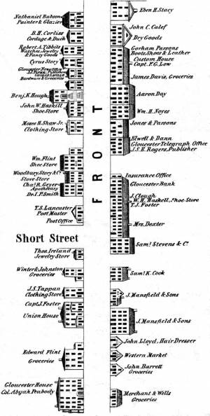
Using the Walling map of Gloucester Harbor, wharves and buildings around Harbor Cove were identified and labeled, then matched to corresponding structures in the Coast Survey chart. With the right and left margins of the drawing determined, the angle of view and its center line were drawn and the angle of view measured as 60 degrees. This agrees closely with Lane’s practice in other drawings where the angles of view are usually multiples of 15 degrees, suggesting his use of a viewing aid, possibly divided into quadrants as promoted by the Danish artist Eckersberg and his followers.
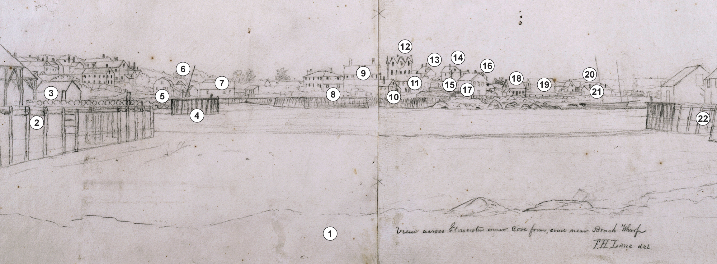
Key to drawing showing buildings and wharves depicted.
Working clockwise from Beach Street on the causeway to Fort Point:
- Graving beach- tidal land set aside by the town for grounding vessels at low tide to clean, repair, and apply antifouling to hull bottoms.
- Wharf of J. J. Procter’s estate.
- Wharves of George H. Rogers.
- Wharf extension of George H. Rogers, built to allow berthing of a deep-laden cargo vessel when the tide was too low to permit the vessel to tie up at the main wharf for unloading. This probably preceded the institution of harbor commission lines banning detached pier heads and placing limits on wharf extensions.
- Wharf of William Collins estate. This wharf, and its gambrel-roof building are shown in detail The Fort and Ten Pound Island, Gloucester (Harbor Scene), 1848 (inv. 58), together with a rare depiction by Lane of shipbuilding.
- Mast-stepping crane on wharf of Collins estate, also seen in The Fort and Ten Pound Island, Gloucester (Harbor Scene), 1848 (inv. 58).
- Building belonging to Captain Frederick G. Low, not shown in Walling’s map, but shown on The Coast Survey chart. Probably used as a warehouse.
- Wharf of Captain Frederick G. Low, who owned other wharves and most of the land on Duncan’s Point, including the lot and subsequent parcels which he sold to Lane to build his house and plant his gardens. Lane’s depictions of the Duncan Street wharves show clearly that they are of cob wharf construction.
- Residential building belonging to Frederick G. Low.
- Fears Wharf and sail loft.
- Residence of Fitz E. Riggs, who owned a wharf on the west end of Harbor Cove, off Beach Street (shown in Walling’s map).
- Residence of Fitz Henry Lane (sole owner) and family of Ignatius Winter (boarders).
- Building owned by Joseph Shepherd.
- Residential building owned and occupied by Joseph Shepherd.
- Building owned by Warren Burnham.
- Building owned by Low and Stacy.
- Wharf and building owned by Frederick G. Low.
- Building owned by Warren Burnham.
- Burnham Brothers marine railway – hauling shed at head of hauling ways.
- Burnham Brothers marine railway – work shop and store.
- Parker Burnham – work shop and/or store.
- Wharf of John W. Lowe.
- Subject Types
: - Vessel Activites
: - At Wharf »
- Cape Ann Locales
:
Historical Materials
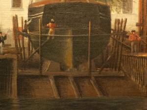
Lane was commissioned by his neighbor John Trask to paint a sign for his shop at the Burnham Brothers' Marine Railway, as seen in Three Master on the Gloucester Railways, 1857 (inv. 29). The railway, built in 1849-50, was a vital component of the ship building and repair trade, allowing large ships to be hauled out of the water to repair and clean the hulls. Originally there was just one railway, but a second was added due to increased demand. It consisted of a heavily reinforced timber structure anchored with iron spikes and topped with pairs of iron rails fitted with cast iron rollers. The vessel was hauled onto a wood cradle using a steam-powered winch, where it remained, blocked to prevent movement, for the duration of the repairs. Upgrades to the steam power plant can be observed when comparing the height of the smokestack in the painting with that in the later print View of Gloucester, 1859 (inv. 446). This may also be visible in drawings such as Gloucester from Fresh Water Cove, 1850s (inv. 144). Burnham’s was probably up-dating its steam power plant, not just to run power saws, but to power the steam winch which pulled the cradle with a ship on it up the rails.
Gloucester City Archives, Valuations for Harbor Parish, East Ward, 1851, 1852, 1853, 1854.
Valuations for wharf facilities and railway, 1851: $3,280; 1852: $4,800; 1853: $6,000; 1854: $9,000.
This steady and substantial growth is hard to explain in any other way than in the form of mechanical improvements, including steam-powered machinery to operate the hauling winch and power saws for a mill building for shipbuilding timber and planking. A note in the 1853 valuation, simply stating “new railway”, probably refers to the addition of a second railway, which would account for the significantly higher valuation in 1854.
Erik Ronnberg
Mounted print
8 x 10 in.
Cape Ann Museum Library & Archive
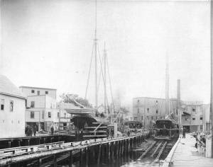
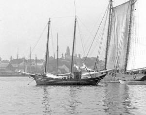
Railway at the tip of Duncan's Point. Vessels on the ways are "Isabell Leighton" and "Hattie B. West."
Also filed under: Duncan's Point »
Wood, cordage, acrylic paste, metal
~40 in. x 30 in.
Erik Ronnberg
Model shows mast of fishing vessel being unstepped.
Also filed under: Fishing » // Schooner (Fishing) »

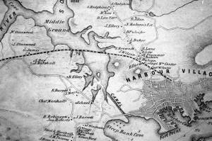
1851 44 x 34 in. Henry Francis Walling, Map of the Towns of Gloucester and Rockport, Essex Co. Massachusetts. Philadelphia, A. Kollner, 1851 Cape Ann Museum Library & Archive
"Map of the Towns of Gloucester and Rockport, Massachusetts. H.F. Walling, Civil Engineer. John Hanson, Printer. 1851. Population of Gloucester in 1850 7,805. Population of Rockport in 1850 3,213."
Also filed under: Baptist Church (Old, First, 1830) (Pleasant Street) » // Duncan's Point » // Five Pound Island » // Flake Yard » // Gloucester Harbor, Inner / Harbor Cove » // Harbor Methodist Church (Prospect Street) » // Low (Frederick G.) wharves » // Pavilion Hotel » // Procter Brothers » // Ropewalk » // Vincent's Cove » // Western Shore »
Newsprint
From bound volume owned by publisher Francis Procter
Collection of Fred and Stephanie Buck
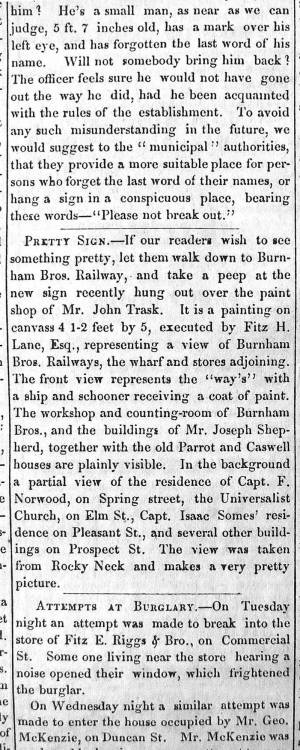
“PRETTY SIGN. – If our readers wish to see something pretty, let them walk down to Burnham Bros. Railway, and take a peep at the new sign recently hung out over the paint shop of Mr. John Trask. It is a painting on canvass 4 1-2 feet by 5, executed by Fitz H. Lane, Esq., representing a view of Burnham Bros. Railways, the wharf and stores adjoining. The front view represents the ‘way’s’ with a ship and schooner receiving a coat of paint. The workshop and counting-room of Burnham Bros., and the buildings of Mr. Joseph Shepherd, together with the old Parrot and Caswell houses are plainly visible. In the background a partial view of the residence of Capt. F. Norwood, on Spring street, the Universalist Church, on Elm St., Capt. Isaac Somes’ residence on Pleasant St., and several other buildings on Prospect St. The view was taken from Rocky Neck and makes a very pretty picture.”
Also filed under: Chronology » // John Trask Paint Store » // Newspaper / Journal Articles » // Trask, John »
Newspaper
Fire in the steam planing mill of Parker Burnham & Bros, foot of Water St. It spread through the block that included Ignatius Winter's sash-and-blind factory and John Trask's paint shop.
Also filed under: Newspaper / Journal Articles » // Trask, John » // Winter, Ignatius »

1865 41 x 29 inches Courtesy of the Massachusetts Archives Maps and Plans, Third Series Maps, v.66:p.1, no. 2352, SC1/series 50X
.
Also filed under: Collins's, William (estate wharf) » // Gloucester Harbor, Inner / Harbor Cove » // Maps » // Rogers's (George H.) wharves »
Newspaper obituary
Obituary of Parker Burnham, Esq.
Sawyer Free Library
Parker Burnham, Esq., the alderman from Ward 5, died at his residence on Spring Street on Thursday morning, of neuralgia of the heart, after a few days’ illness. Mr. Burnham was a native of Essex, son of the venerable Parker Burnham, recently deceased, but settled in Gloucester when quite a young man, and has been closely identified with the business interests of the town and city. On his removal to Gloucester, in connection with his brothers, Joseph B. and Elias, he established a shipyard, and the firm, under the name of Burnham Brothers, were successfully engaged in the building and repairing of vessels. Subsequently they built the first marine railways ever constructed in Gloucester, and in the business connected therewith Mr. Burnham remained to the time of his death. He was a man of marked character, honest in his dealings, kindly in his intercourse with his fellows, correct in his deportment and unassuming in his manners, devoting himself to his business without stepping aside to seek notoriety or distinction from his fellow citizens. In religion he was a Universalist and a regular attendant upon the services of the Independent Christian Church. In politics he was a Republican from the earliest formation of the party, and fully in accord with its principles, although he was elected upon the Board of Aldermen upon a democratic nomination, unsought, by a large majority. Since the organization of the city government Mr. Burnham has devoted a large portion of his time to the interests of the city, being constant in his attendance upon the meetings of the board and taking an active part in its deliberations. As chairman of the joint standing committee upon public property he had the oversight upon the Collins School House and the investigations concerning the remodeling of the City Hall; he was also a member of the committees upon finance and highways. His loss will be deeply felt by his associates in the city council, and by the community generally. His funeral took place on Saturday afternoon, and was attended by the members of the city council in a body.
Newspaper obituary
Obituary of Elias Burnham
Sawyer Free Library
Mr. Elias Burnham, whose severe illness was alluded to in our last issue, died at eleven o’clock on Saturday morning, having been unconscious for several hours before his death. He had been in his usual health until within a little over a week before his departure, when he was taken with an ill turn at the camp of his son, Mr. Elias P. Burnham, at West Gloucester, and grew rapidly worse until the end. Mr. Burnham was a native of Essex, being a son of Parker Burnham of that town. He was a ship carpenter by trade, and came to Gloucester over forty years ago with his brothers Parker and Joseph B., and engaged in the vessel building business on Pearce’s wharf, under the name of Burnham Brothers. Subsequently the firm purchased the Hough wharf, now owned by Walen & Son, and on the flats adjoining built the first marine railway ever constructed in Gloucester. To this business they afterwards added a planing mill, doing an extensive business. Mr. Joseph B. Burnham withdrew from the firm several years ago, carrying on for several years a planing mill on Pearce Street, and Mr. Parker Burnham, the oldest of the brothers, died in 1874, the firm of late years consisting of Elias, Elias P., son of Elias, and Parker H. and Enoch, sons of Parker. Identified for nearly half a century with the business interests of Gloucester, Mr. Burnham won a high place in the regard of his fellow citizens by his industrious habits, by the promptness and honesty which characterized all his business transactions, by his kindly social nature, his unassuming manners, and his respect for the rights and opinions of others. He was a prominent member of and liberal contributor to the support of the First Baptist Church, and his loss will be deeply felt by the members of that communion. He leaves a widow, son and daughter. His funeral took place from his late residence on Elm Street on Wednesday afternoon, his pastor, Rev. Dr. Morris officiating, and was largely attended.
Newspaper obituary
Obituary of Joseph Burnham, Esq.
Sawyer Free Library
Mr. Joseph Burnham, for many years a well known resident of this city, died very suddenly at his residence in West Gloucester on Tuesday, of paralysis, in the 67th year of his age. Although in somewhat feeble health of late years, he was able to keep about, and was out of doors the evening before his death. He was a son of Parker Burnham of Essex, and was formerly a member of the firm of Burnham Brothers (Parker, Joseph B. and Elias), who commenced ship- building in this city some two score years and more ago, and afterwards built the first marine railway in Gloucester and established a planing mill. Subsequently he retired from the firm and carried on a planing mill on Pearce Street for a number of years. He was also engaged in the remeasurement of our fishing fleet when the new tonnage law went into effect. Later, he purchased a farm in Rowley, but after a short residence there returned to Gloucester and took up his permanent residence at his summer camp at West Gloucester, where his death occurred.
He was an ingenious mechanic, steady, honest and industrious, and his sudden death will be deeply deplored by a large circle of friends. Mr. Burnham was a veteran Odd Fellow, having long been a member of Ocean Lodge, and was one of the seven charter members of Cape Ann Encampment, from which he withdrew about five years ago. His death is the second among the seven charter members of the Encampment, Capt. Edward Staten having been the first to depart from the earth life. The funeral of the deceased took place yesterday afternoon, Rev. Wm. H. Rider officiating, and was attended by the brethren of Ocean Lodge.

Detail views: marine railway and hauling cradle for vessel Wood rails, metal rollers, chain; wood cradle. Scale: ½" = 1' (1:24) Original diorama components made, 1892; replacements made, 1993. Cape Ann Museum, from Gloucester Chamber of Commerce, 1925 (2014.071)
A schooner is shown hauled out on a cradle which travels over racks of rollers on a wood and metal track.
Also filed under: Marine Railways » // Schooner (Coasting / Lumber / Topsail / Packet / Marsh Hay) »
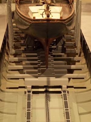
Wood rails, metal rollers, chain; wood cradle. Scale: ½" = 1' (1:24)
Original diorama components made, 1892; replacements made, 1993.
Cape Ann Museum, from Gloucester Chamber of Commerce, 1925 (2014.071)
Close up showing detail of rollers and hauling chain.
Also filed under: Marine Railways »
44 x 34 in.
John Hanson, Publisher
Cape Ann Museum Library & Archive
Also filed under: Marine Railways »
Oil on canvas
39 1/4 x 59 1/4 in.
Detail showing construction of marine railway. Details of the rollers and chain are obscured due to past cleaning efforts.
Also filed under: Marine Railways »
William Collins likely inherited his father's blockmaking business in 1810, including a shop and the wharf at the head of Harbor Cove. Blockmaking, which included the making of various types of rigging fittings (blocks, deadeyes, belaying pins, cleats, etc.) called for skilled workmanship and use of special types of wood. Inventories and auction announcements for William Collins’ estate give long lists of tools, materials, and products from his business. (Ref. 1)
Maps of the harbor from 1835 identify the wharf as Collins property, one of them being labeled “Wm. Collins”, suggesting sole ownership by then. When William Collins died in 1845, the property remained in the hands of his family, as indicated in Walling’s map of Cape Ann (1851) and in the Commissioner’s Map of Gloucester Harbor (1865).
Collins’ death did not mean the end of his wharf’s use in his line of work. An announcement in "The Gloucester Telegraph" that year stated that Parker Burnham & Brothers would resume the blockmaking business on the wharf, along with sparmaking and carpentry. All those activities were associated not just with shipbuilding, but with vessel maintenance and repair. They possibly marked the beginning of a major change in the Burnhams’ business, which had focused on shipbuilding to this point, but was now shifting to vessel repairs, and would lead to their building Gloucester’s first marine railway half a decade later.(Ref. 3)
– Erik Ronnberg
References:
1. “Gloucester Telegraph”, April 2, 1845. Administrator’s Sale, April 9, 10 o’clock, Wm. P. Dolliver, Adm’r. Massachusetts Archives, Probate Records, Essex County, March 1845.
2. Henry F. Walling, “Map of the Towns of Gloucester and Rockport, Essex County, Massachusetts” (Philadelphia: A. Kollner, 1851). “Commissioners” Map of Gloucester Harbor, Massachusetts” (Commissioners on Harbors and Flats of the Commonwealth, October, 1865).
3. “Gloucester Telegraph”, May 7, 1845. “Removal”, Parker Burnham & Brothers, Gloucester, April 23, 1845.
4.2.1845 Newspaper announcement Gloucester Telegraph Cape Ann Museum Library & Archive
AUCTION
ADMINISTRATOR’S SALE
ON WEDNESDAY, April 9th, 10 o’clock Workshop of Wm. Collins (deceased) near Willam Burnham’s, will be sold. ALL the STOCK, TOOLS. &c. &c., of said shop,
Consisting in part as follows, About 400 Blocks of different sizes; 600 unfinish-ed Blocks; lot of Lignumvita Belaying Pins; Jib Hanks; Hand Pumps; 2 Guns; Handspikes; Knives; 1 large Grindstone; Saws; Gouges; Chisels; Planes; Augers; Bitt Stocks and Bitts; 1 Turning Lathe; 2 Vices; Stove and Funnel; Crow Bars; Hammer and Drills; Wheelbarrow; 2 large New Purchase Blocks; 2 second hand do. do.; together with a variety of other articles too numerousto mention.
Also, a SAIL BOAT
Wm. P. DOLLIVER, Adm’r.
If it should be foul weather, the sale will take
Place the first fair day after. March 29
Also filed under: Collins, William » // Newspaper / Journal Articles »
5.7.1845 Newspaper announcement Gloucester Telegraph Cape Ann Museum Library & Archive
REMOVAL.
The Subscribers have taken the Wharf of the Late Mr. Wm. Collins, where they will keep a large assortment of good BLOCKS, MAST HOOPS, JIB HANKS, Hand and Vessel PUMPS, and all articles made in a Block Maker’s Shop. Blocks repaired and Well Pumps made at short notice. They will also carry on Spar making with their Carpentering business.
PARKER BURNHAM & BROTHERS.
Gloucester, April 23, 1845
Also filed under: Newspaper / Journal Articles »
1851 44 x 34 in. Henry Francis Walling, Map of the Towns of Gloucester and Rockport, Essex Co. Massachusetts. Philadelphia, A. Kollner, 1851 Cape Ann Museum Library & Archive
"Map of the Towns of Gloucester and Rockport, Massachusetts. H.F. Walling, Civil Engineer. John Hanson, Publisher. 1851. Population of Gloucester in 1850 7,805. Population of Rockport in 1850 3,213."
Segment of Harbor Village portion of map showing Collins' and other wharves in the Inner Harbor.
1865 41 x 29 inches Courtesy of the Massachusetts Archives Maps and Plans, Third Series Maps, v.66:p.1, no. 2352, SC1/series 50X
.
Also filed under: Burnham Brothers Marine Railway » // Gloucester Harbor, Inner / Harbor Cove » // Maps » // Rogers's (George H.) wharves »
In the 1850s, Captain Frederick G. Low owned fully one-third of the land comprising Duncan's point, including the lot purchased by Lane for his home and studio. Much of his property fronted the Inner Harbor, including two wharves in Harbor Cove and a third jutting southeast from the point toward Harbor Rock (see Walling & Hanson map below.)
Low's wharves are not conspicuous in any of Lane's depictions of Gloucester Harbor, which is ironic because many of his harbor scenes were sketched from Low's property. In The Fort and Ten Pound Island, Gloucester (Harbor Scene), 1848 (inv. 58), his wharf adjacent to the Collins estate wharf is obscured by a building on the Collins wharf and a ship tied up to his own wharf. In Gloucester Harbor, 1852 (inv. 38), his wharf extending to Harbor Rock is concealed by the rocks off Fort Point with only a bark to mark the head of the wharf to which it is tied up.
Gloucester Harbor from Rocky Neck, 1844 (inv. 14), depicting the town from Rocky Neck, is the only painting which shows the shore line where Lowe's wharves were located (or to be located, given the early, 1844, date of this work). Lane's lithograph of 1846 (View of Gloucester, (From Rocky Neck), 1846 (inv. 57)) is similarly problematic, and his 1859 version () shows so many changes that the earlier wharves are no longer discernible.
– Erik Ronnberg
Watercolor on paper
Cape Ann Museum Library & Archive
Also filed under: Maps » // Unitarian Church / First Parish Church (Middle Street) »
1851 44 x 34 in. Henry Francis Walling, Map of the Towns of Gloucester and Rockport, Essex Co. Massachusetts. Philadelphia, A. Kollner, 1851 Cape Ann Museum Library & Archive
"Map of the Towns of Gloucester and Rockport, Massachusetts. H.F. Walling, Civil Engineer. John Hanson, Printer. 1851. Population of Gloucester in 1850 7,805. Population of Rockport in 1850 3,213."
Also filed under: Baptist Church (Old, First, 1830) (Pleasant Street) » // Burnham Brothers Marine Railway » // Duncan's Point » // Five Pound Island » // Flake Yard » // Gloucester Harbor, Inner / Harbor Cove » // Harbor Methodist Church (Prospect Street) » // Pavilion Hotel » // Procter Brothers » // Ropewalk » // Vincent's Cove » // Western Shore »

1834–35 Lithograph 24 x 38 in. Gloucester City Archives
"Drawn on a scale of one hundred feet to an inch. By John Mason 1834–45 from Actual Survey showing every Lott and building then standing on them giving the actual size of the buildings and width of the streets from the Canal to the head of the Harbour & part of Eastern point as farr as Smith's Cove and the Shore of the same with all the wharfs then in use. Gloucester Harbor 1834–35."
This map shows the location of F. E. Low's wharf and the ropewalk. Duncan's Point, the site where Lane would eventually build his studio, is also marked.
The later notes on the map are believed to be by Mason.
Also filed under: Duncan's Point » // Gloucester Harbor, Inner / Harbor Cove » // Low, Capt. Frederick Gilman » // Maps » // Mason, John » // Residences » // Ropewalk » // Somes, Capt. John »
44 x 34 in.
Henry Francis Walling, Map of the Towns of Gloucester and Rockport, Essex Co. Massachusetts. Philadelphia, A. Kollner, 1851
Cape Ann Museum Library & Archive
"Map of the Towns of Gloucester and Rockport, Massachusetts. H.F. Walling, Civil Engineer. John Hanson, Publisher. 1851. Population of Gloucester in 1850 7,805. Population of Rockport in 1850 3,213."
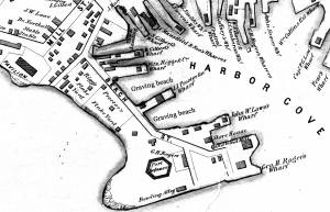
Segment of Harbor Village portion of map showing Low's, Rogers', and other wharves in the Inner Harbor.
Also filed under: Rogers's (George H.) wharves »
44 x 34 in.
Henry Francis Walling, Map of the Towns of Gloucester and Rockport, Essex Co. Massachusetts. Philadelphia, A. Kollner, 1851
Cape Ann Museum Library & Archive
"Map of the Towns of Gloucester and Rockport, Massachusetts. H.F. Walling, Civil Engineer. John Hanson, Publisher. 1851. Population of Gloucester in 1850 7,805. Population of Rockport in 1850 3,213."

44 x 34 in.
John Hanson, Publisher
Cape Ann Museum Library & Archive
"Map of the Towns of Gloucester and Rockport, Massachusetts. H.F. Walling, Civil Engineer. John Hanson, Publisher. 1851. Population of Gloucester in 1850 7,805. Population of Rockport in 1850 3,213."
Also filed under: Fort (The) and Fort Point » // Maps » // Rogers's (George H.) wharves » // Town / Public Landings » // Waterfront, Gloucester » // Windmill »
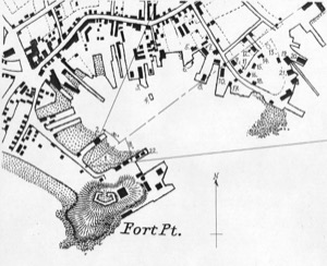
George H. Rogers was one of Gloucester's most enterprising citizens of the mid-nineteenth century. In the early 1830s, he ventured into the Surinam trade with great success, leading him to acquire a wharf at the foot of Sea Street. Due to Harbor Cove's shallow bottom at low tide, berthings at wharves had to be done at high tide, leaving the ships grounded at other times. Many deep-loaded vessels had to anchor outside Harbor cove and be partially off-loaded by "lighters" (shallow-draft vessels that could transfer cargo to the wharves) before final unloading at wharfside. To lessen this problem, Rogers had an unattached extension built out from his wharf into deeper water (see The Fort and Ten Pound Island, Gloucester (Harbor Scene), 1848 (inv. 58), right middle ground). The space between the old wharf and the extension may have been a way to evade harbor regulations limiting how far a pier head could extend into the harbor. Stricter rules were not long in coming after this happened!
About 1848, Rogers acquired land on the east end of Fort Point, first putting up a large three-story building adjacent to Fort Defiance, then a very large wharf jutting out into Harbor Cove. Lane's depictions of Harbor Cove and Fort Point show progress of this construction in 1848 (The Fort and Ten Pound Island, Gloucester (Harbor Scene), 1848 (inv. 58)), 1850 (Gloucester Inner Harbor, 1850 (inv. 240)), and c.1851 (Gloucester Harbor at Dusk, c.1852 (inv. 563)). A corner of the new wharf under construction can also be seen more closely in Ten Pound Island, Gloucester, 1850s (inv. 17) and Ten Pound Island in Gloucester Harbor, 1864 (inv. 104) (foregrounds). This new wharf provided better frontage for large ships to load and unload, as well as larger warehouses and lofts for storage of goods and vessel gear.
By 1860, Rogers was unloading his Surinam cargos at Boston, as ever-larger ships and barks were more easily berthed there. His Gloucester wharves continued to be used for deliveries of trade goods by smaller vessels. In the late 1860s, Rogers' wharf at Fort Point (called "Fort Wharf" in Gloucester directories) was acquired by (Charles D.) Pettingill & (Nehemiah) Cunningham for use in "the fisheries" as listed by the directory. in 1876, it was sold to (John J.) Stanwood & Company, also for use in "the fisheries." (1)
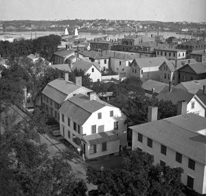
Lowe's Wharf, adjacent to Fort Wharf, was acquired by (Sylvester) Cunningham & (William) Thompson, c.1877 and used in "the fisheries" as well. That wharf and its buildings were enlarged considerably as the business grew. By this time, Harbor Cove was completely occupied by businesses in the fisheries or providing services and equipment to the fishing fleet. In photographs of Fort Point from this period, it is difficult to distinguish one business from another, so closely are they adjoined.
– Erik Ronnberg
Reference:
1. A city atlas, dated 1899, indicates that Rogers's wharf at Fort Point was still listed as part of his estate. If so, then Stanwood & Co. would have been leasing that facility from the Rogers's estate.
44 x 34 in.
Henry Francis Walling, Map of the Towns of Gloucester and Rockport, Essex Co. Massachusetts. Philadelphia, A. Kollner, 1851
Cape Ann Museum Library & Archive
"Map of the Towns of Gloucester and Rockport, Massachusetts. H.F. Walling, Civil Engineer. John Hanson, Publisher. 1851. Population of Gloucester in 1850 7,805. Population of Rockport in 1850 3,213."
Segment of Harbor Village portion of map showing Low's, Rogers', and other wharves in the Inner Harbor.
Also filed under: Low (Frederick G.) wharves »
44 x 34 in.
Henry Francis Walling, Map of the Towns of Gloucester and Rockport, Essex Co. Massachusetts. Philadelphia, A. Kollner, 1851
Cape Ann Museum Library & Archive
"Map of the Towns of Gloucester and Rockport, Massachusetts. H.F. Walling, Civil Engineer. John Hanson, Publisher. 1851. Population of Gloucester in 1850 7,805. Population of Rockport in 1850 3,213."
44 x 34 in.
John Hanson, Publisher
Cape Ann Museum Library & Archive
"Map of the Towns of Gloucester and Rockport, Massachusetts. H.F. Walling, Civil Engineer. John Hanson, Publisher. 1851. Population of Gloucester in 1850 7,805. Population of Rockport in 1850 3,213."
Also filed under: Fort (The) and Fort Point » // Low (Frederick G.) wharves » // Maps » // Town / Public Landings » // Waterfront, Gloucester » // Windmill »
1865 41 x 29 inches Courtesy of the Massachusetts Archives Maps and Plans, Third Series Maps, v.66:p.1, no. 2352, SC1/series 50X
.
Also filed under: Burnham Brothers Marine Railway » // Collins's, William (estate wharf) » // Gloucester Harbor, Inner / Harbor Cove » // Maps »

1876 Photograph Cape Ann Museum Library & Archive
Ignatius Weber's windmill (now defunct) is shown.
Also filed under: Flake Yard » // Fort (The) and Fort Point » // Gloucester Harbor, Inner / Harbor Cove » // Historic Photographs » // Schooner (Fishing) » // Waterfront, Gloucester » // Windmill »
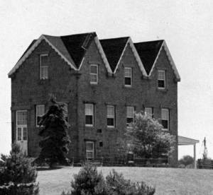
In 1849, Lane bought a small lot of land on top of a hill that jutted into Gloucester Inner Harbor. The name Duncan's Point refers alternatively to the entire hill, or only to the rocks that form a point beneath the current Coast Guard Station. The hilltop was vacant when Lane bought the property. He designed and built a gabled stone house on the hill, the northwest room of which was his studio. He lived there with his sister Sarah and her husband, Ignatius Winter, until he died in 1865, having bequeathed the house to his friend, Joseph L. Stevens, Jr. (1)
Reference:
1. Sarah Dunlop and Stephanie Buck, Fitz Henry Lane: Family and Friends (Gloucester, MA: Church & Mason Publishing; in association with the Cape Ann Historical Museum, 2007), 59–74, 150–55.
c.1869 Glass plate negative Cape Ann Museum Library & Archive Detail from CAHA#00279
The magnificent views of Gloucester Harbor and the islands from the top floor of the stone house at Duncan's Point where Lane had his studio were the inspiration for many of his paintings.
From Buck and Dunlop, Fitz Henry Lane: Family, and Friends, pp. 59–74.
Also filed under: Gloucester Harbor, Inner / Harbor Cove » // Lane's Stone House, Duncan's Point » // Residences »
1851 44 x 34 in. Henry Francis Walling, Map of the Towns of Gloucester and Rockport, Essex Co. Massachusetts. Philadelphia, A. Kollner, 1851 Cape Ann Museum Library & Archive
"Map of the Towns of Gloucester and Rockport, Massachusetts. H.F. Walling, Civil Engineer. John Hanson, Printer. 1851. Population of Gloucester in 1850 7,805. Population of Rockport in 1850 3,213."
Also filed under: Baptist Church (Old, First, 1830) (Pleasant Street) » // Burnham Brothers Marine Railway » // Five Pound Island » // Flake Yard » // Gloucester Harbor, Inner / Harbor Cove » // Harbor Methodist Church (Prospect Street) » // Low (Frederick G.) wharves » // Pavilion Hotel » // Procter Brothers » // Ropewalk » // Vincent's Cove » // Western Shore »
1834–35 Lithograph 24 x 38 in. Gloucester City Archives
"Drawn on a scale of one hundred feet to an inch. By John Mason 1834–45 from Actual Survey showing every Lott and building then standing on them giving the actual size of the buildings and width of the streets from the Canal to the head of the Harbour & part of Eastern point as farr as Smith's Cove and the Shore of the same with all the wharfs then in use. Gloucester Harbor 1834–35."
This map shows the location of F. E. Low's wharf and the ropewalk. Duncan's Point, the site where Lane would eventually build his studio, is also marked.
The later notes on the map are believed to be by Mason.
Also filed under: Gloucester Harbor, Inner / Harbor Cove » // Low (Frederick G.) wharves » // Low, Capt. Frederick Gilman » // Maps » // Mason, John » // Residences » // Ropewalk » // Somes, Capt. John »
44 x 34 in.
Henry Francis Walling, Map of the Towns of Gloucester and Rockport, Essex Co. Massachusetts. Philadelphia, A. Kollner, 1851
Cape Ann Museum Library & Archive
"Map of the Towns of Gloucester and Rockport, Massachusetts. H.F. Walling, Civil Engineer. John Hanson, Publisher. 1851. Population of Gloucester in 1850 7,805. Population of Rockport in 1850 3,213."
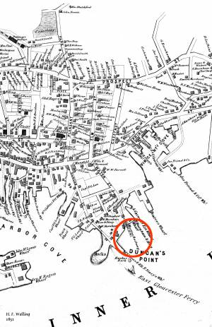
Segment of Harbor Village portion of map showing Lane-Winter property on Duncan's Point.
Also filed under: Maps » // Union School » // Winter, Ignatius »
Cape Ann Museum Library & Archive
Segment shows Lane's home on Duncan's Point (as F. G. Low property) and neighboring businesses about five years after his death.
Also filed under: Maps »
Mounted print
8 x 10 in.
Cape Ann Museum Library & Archive
Railway at the tip of Duncan's Point. Vessels on the ways are "Isabell Leighton" and "Hattie B. West."
Also filed under: Burnham Brothers Marine Railway »

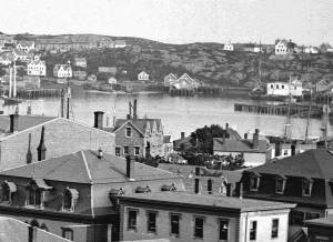
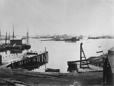
c.1870 Cape Ann Museum Library & Archive (2013.068)
Schooner fleet anchored in the inner harbor. Looking east from Rocky Neck, Duncan's Point wharves and Lane house (at far left), Sawyer School cupola on Friend Street.
Also filed under: Gloucester Harbor, Inner / Harbor Cove » // Historic Photographs » // Schooner (Fishing) » // Waterfront, Gloucester »
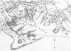
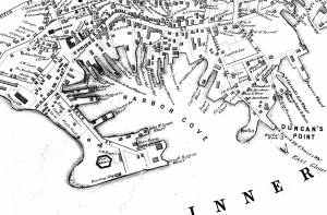
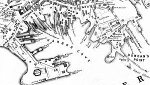
The northeast quarter of Gloucester Harbor is an inlet bounded by Fort Point and Rocky Neck at its entrance. It is further indented by three coves: Harbor Cove and Vincent’s Cove on its north side, and Smith’s Cove on its south side. The shallow northeast end is called Head of the Harbor. Collectively, this inlet with its coves and shallows is called Inner Harbor.
The entrance to Inner Harbor is a wide channel bounded by Fort Point and Duncan’s Point on its north side, and by Rocky Neck on its south side. From colonial times to the late nineteenth century, it was popularly known as “the Stream” and served as anchorage for deeply loaded vessels for “lightering” (partial off-loading). Subsequently it was known as “Deep Hole.”
Of Inner Harbor’s three coves, Harbor Cove (sometimes called “Old Harbor” in later years) was the deepest and most heavily used by fishing vessels in the Colonial Period, and largely dominated by the foreign trade in the first half of the nineteenth century. Its shallow bottom was the undoing of the foreign trade, as larger vessels became too deep to approach its wharves, and the cove returned to servicing a growing fishing fleet in the 1850s.
Vincent’s Cove, a smaller neighbor to Harbor Cove, was bare ground at low tide, and mostly useless for wharfage. Its shoreline was well suited for shipbuilding, and the cove was deep enough at high tide for launching. Records of shipbuilding there prior to the early 1860s have to date not been found.Smith’s Cove afforded wharfage for fishing vessels at its east entrance, as seen in Lane’s lithograph View of the Town of Gloucester, Mass., 1836 (inv. 86). The rest of the cove saw little use until the expansion of the fisheries after 1865.
The Head of the Harbor begins at the shallows surrounding Five Pound Island, extending to the harbor’s northeast end. Lane’s depiction of this area in Gloucester Harbor, 1847 (inv. 23) shows the problems faced by vessel owners at low tide. Despite the absence of deep water, this area saw rapid development after 1865 when a thriving fishing industry needed waterfront facilities, even if they were accessible only at high tide.
– Erik Ronnberg
c.1870 Cape Ann Museum Library & Archive (2013.068)
Schooner fleet anchored in the inner harbor. Looking east from Rocky Neck, Duncan's Point wharves and Lane house (at far left), Sawyer School cupola on Friend Street.
Also filed under: Duncan's Point » // Historic Photographs » // Schooner (Fishing) » // Waterfront, Gloucester »
1876 Photograph Cape Ann Museum Library & Archive
Also filed under: Historic Photographs » // Schooner (Fishing) » // Waterfront, Gloucester »
1851 44 x 34 in. Henry Francis Walling, Map of the Towns of Gloucester and Rockport, Essex Co. Massachusetts. Philadelphia, A. Kollner, 1851 Cape Ann Museum Library & Archive
"Map of the Towns of Gloucester and Rockport, Massachusetts. H.F. Walling, Civil Engineer. John Hanson, Printer. 1851. Population of Gloucester in 1850 7,805. Population of Rockport in 1850 3,213."
Also filed under: Baptist Church (Old, First, 1830) (Pleasant Street) » // Burnham Brothers Marine Railway » // Duncan's Point » // Five Pound Island » // Flake Yard » // Harbor Methodist Church (Prospect Street) » // Low (Frederick G.) wharves » // Pavilion Hotel » // Procter Brothers » // Ropewalk » // Vincent's Cove » // Western Shore »

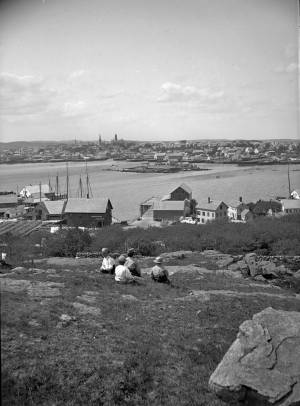
4 x 6 in.
Cape Ann Museum, Benham Collection
George Steele sail loft, William Jones spar yard, visible across harbor. Photograph is taken from high point on the Fort, overlooking business buildings on the Harbor Cove side.
Also filed under: Fort (The) and Fort Point » // Town House » // Universalist Church (Middle and Church Streets) » // Waterfront, Gloucester »

1834–35 Lithograph 24 x 38 in. Gloucester City Archives
"Drawn on a scale of one hundred feet to an inch. By John Mason 1834–45 from Actual Survey showing every Lott and building then standing on them giving the actual size of the buildings and width of the streets from the Canal to the head of the Harbour & part of Eastern point as farr as Smith's Cove and the Shore of the same with all the wharfs then in use. Gloucester Harbor 1834–35."
This map shows the location of F. E. Low's wharf and the ropewalk. Duncan's Point, the site where Lane would eventually build his studio, is also marked.
The later notes on the map are believed to be by Mason.
Also filed under: Duncan's Point » // Low (Frederick G.) wharves » // Low, Capt. Frederick Gilman » // Maps » // Mason, John » // Residences » // Ropewalk » // Somes, Capt. John »
44 x 34 in.
Henry Francis Walling, Map of the Towns of Gloucester and Rockport, Essex Co. Massachusetts. Philadelphia, A. Kollner, 1851
Cape Ann Museum Library & Archive
"Map of the Towns of Gloucester and Rockport, Massachusetts. H.F. Walling, Civil Engineer. John Hanson, Publisher. 1851. Population of Gloucester in 1850 7,805. Population of Rockport in 1850 3,213."
Segment of Harbor Village portion of map showing Collins' and other wharves in the Inner Harbor.
Also filed under: Graving Beach »

Collection of Erik Ronnberg
View related catalogue entries (2) »
Also filed under: Dolliver's Neck » // Fresh Water Cove » // Gloucester Harbor, Outer » // Maps »
1865 41 x 29 inches Courtesy of the Massachusetts Archives Maps and Plans, Third Series Maps, v.66:p.1, no. 2352, SC1/series 50X
.
Also filed under: Burnham Brothers Marine Railway » // Collins's, William (estate wharf) » // Maps » // Rogers's (George H.) wharves »
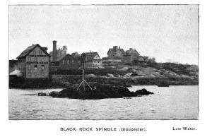
Photograph in The Illustrated Coast Pilot with Sailing Directions. The Coast of New England from New York to Eastport, Maine including Bays and Harbors, published by N. L. Stebbins, Boston
Also filed under: Beacons / Monuments / Spindles »
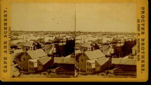
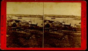
Stereograph card Cape Ann Museum Library & Archive
Also filed under: Gloucester – City Views » // Historic Photographs »
c.1870s Stereograph card Cape Ann Museum Library & Archive
From East Gloucester looking towards Gloucester.
Also filed under: Gloucester – City Views » // Historic Photographs »
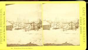
1876 Stereograph card Cape Ann Museum Library & Archive
Stereo view showing Gloucester Harbor after a heavy snowfall
Also filed under: Historic Photographs » // Waterfront, Gloucester »
Cape Ann Museum Library & Archive
Five Pound Island and Gloucester inner harbor taken from the top of Hammond Street building signs in foreground are for Severance, Carpenter and Crane, and Cooper at Clay Cove.
Also filed under: Five Pound Island »
1852
Oil on canvas
28 x 48 1/2 in.
Cape Ann Museum, Gloucester, Mass., Deposited by the City of Gloucester, 1952. Given to the city by Mrs. Julian James in memory of her grandfather Sidney Mason, 1913 (DEP. 200)
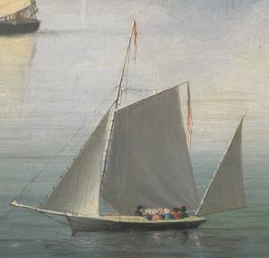
Detail of fishing schooner.
Also filed under: Schooner (Fishing) »
Oil on canvas
34 x 45 3/4 in.
Cape Ann Museum, Gloucester, Mass., Gift of Mrs. Jane Parker Stacy (Mrs. George O. Stacy),1948 (1289.1a)
Detail of party boat.
Also filed under: Party Boat »
c.1869 Glass plate negative Cape Ann Museum Library & Archive Detail from CAHA#00279
The magnificent views of Gloucester Harbor and the islands from the top floor of the stone house at Duncan's Point where Lane had his studio were the inspiration for many of his paintings.
From Buck and Dunlop, Fitz Henry Lane: Family, and Friends, pp. 59–74.
Also filed under: Duncan's Point » // Lane's Stone House, Duncan's Point » // Residences »
Glass plate negative
3 x 4 in.
Cape Ann Museum Library & Archive
#10112
Also filed under: Chebacco Boat / Dogbody / Pinky »
1876 Photograph Cape Ann Museum Library & Archive
Ignatius Weber's windmill (now defunct) is shown.
Also filed under: Flake Yard » // Fort (The) and Fort Point » // Historic Photographs » // Rogers's (George H.) wharves » // Schooner (Fishing) » // Waterfront, Gloucester » // Windmill »

1860 In John J. Babson, History of the Town Gloucester (Gloucester, MA: Procter Brothers, 1860) Cape Ann Museum Library & Archives, Gloucester, Mass.
See p. 474.
View related catalogue entries (4) »
Also filed under: Babson History of the Town of Gloucester » // Chebacco Boat / Dogbody / Pinky » // Fort (The) and Fort Point » // Gloucester, Mass. - "Ten Pound Island Light » // Schooner (Coasting / Lumber / Topsail / Packet / Marsh Hay) » // Ten Pound Island »
From Colonial times to the present, Gloucester and other shore-side communities have maintained certain tracts of land as public landings, assuring everyone the right of free access to and from tidal waters. Such ways are carefully delineated in deeds, are to be kept clear of encumbrances and be available for all to pass over. For communities like Gloucester whose economies were based solidly on maritime pursuits throughout the eighteenth and nineteenth centuries, allowing access to navigable waters was essential.
Public landings were designated across Cape Ann including at Folly Cove, the historic Town Green, Done Fudging, Lobster Cove, Cripple Cove and Stanwood Point in West Gloucester. While public access to the water has gradually constricted in recent decades, even during Fitz Henry Lane’s lifetime, landowners guarded their property rights fiercely, making public landings all that more important.
Gloucester's first public landing was on the Annisquam River at the site of the old First Parish (now occupied by the Grant Circle rotary where Route 128 intersects Washington Street). Given the shallows of the river, most goods had to be landed in scows or gundalows—goods such as marsh hay, lumber, livestock, domestic needs, and business wares—in short, everything from the rest of the world.
As one of the earliest pockets of settlement in Gloucester, Fresh Water Cove was another logical and practical place for a public landing to be located and indeed one was laid out there by the town’s founders. It was over that tract of land that granite from the upland quarry, located in what is now Ravenswood, was transported to awaiting sloops in the Cove. The landing was also how shore fishermen would access their boats and carry supplies to and from their homes.
– Martha Oaks
1851 44 x 34 in. Henry Francis Walling, Map of the Towns of Gloucester and Rockport, Essex Co. Massachusetts. Philadelphia, A. Kollner, 1851 Cape Ann Museum Library & Archive
"Map of the Towns of Gloucester and Rockport, Massachusetts. H.F. Walling, Civil Engineer. John Hanson, Publisher. 1851. Population of Gloucester in 1850 7,805. Population of Rockport in 1850 3,213."
Also filed under: Babson House » // Cut, The (Stacy Blvd.) » // White-Ellery House »

1834–35 24 x 38 in. Gloucester City Archives
"Drawn on a scale of one hundred feet to an inch. By John Mason 1834–45 from Actual Survey showing every Lott and building then standing on them giving the actual size of the buildings and width of the streets from the Canal to the head of the Harbour & part of Eastern point as farr as Smith's Cove and the Shore of the same with all the wharfs then in use. Gloucester Harbor 1834–35."
This map is especially helpful in showing the wharves of the inner harbor at the foot of Washington Street.
Also filed under: Dale, Eben B. » // Eastern Railroad » // Flake Yard » // Gloucester Harbor, Inner / Harbor Cove » // Hough, Benjamin Kent » // Maps » // Pavilion (Publick) Beach » // Ropewalk » // Sawyer, Samuel » // Universalist Church (Middle and Church Streets) »

24 x 38 in.
Gloucester City Archives
"Drawn on a scale of one hundred feet to an inch. By John Mason 1834–45 from Actual Survey showing every Lott and building then standing on them giving the actual size of the buildings and width of the streets from the Canal to the head of the Harbour & part of Eastern point as farr as Smith's Cove and the Shore of the same with all the wharfs then in use. Gloucester Harbor 1834–35."
This map is especially useful in showing the Fort.
Also filed under: Flake Yard » // Fort (The) and Fort Point » // Maps » // Mason, John » // Pavilion (Publick) Beach »
44 x 34 in.
John Hanson, Publisher
Cape Ann Museum Library & Archive
"Map of the Towns of Gloucester and Rockport, Massachusetts. H.F. Walling, Civil Engineer. John Hanson, Publisher. 1851. Population of Gloucester in 1850 7,805. Population of Rockport in 1850 3,213."
Also filed under: Fort (The) and Fort Point » // Low (Frederick G.) wharves » // Maps » // Rogers's (George H.) wharves » // Waterfront, Gloucester » // Windmill »
Robert Fears owned a sail loft, mentioned in the Cape Ann Advertiser, February 27, 1858. He was a selectman, mayor, school committee member, and president of Gloucester Fire Insurance Co.
Newsprint
From bound volume owned by publisher Francis Procter
Collection of Fred and Stephanie Buck
"A CARD. – The Ladies of Gloucester who are interested in the Lyceum Library, and who projected the recent Festival in its behalf, take this method of returning their sincere acknowledgements;
To Messrs. F. H. Lane, Addison Center and John Trask for their arduous and truly artistic labors in the preparation of Tableaux; . . .
To Robert Fears, Esq., who gratuitously opened his large and commodious Sail Loft for their use and exerted himself to make their occupancy of it agreeable;...
To Samuel Sawyer, Esq. of Boston, for his generous and unexpected donation of fifty dollars, thereby laying the Library under still another obligation to him;...
Also filed under: Center, Addison » // Gloucester Lyceum » // Newspaper / Journal Articles » // Sawyer, Samuel » // Trask, John »
Newsprint
From bound volume owned by publisher Francis Procter
Collection of Fred and Stephanie Buck
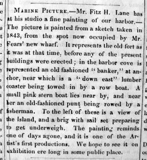
"MARINE PICTURE – Mr. Fitz H. Lane has at his studio a fine painting of our harbor. – The picture is painted from a sketch taken in 1843, from the spot now occupied by Mr Fears' new wharf. It represents the old fort as it was at that time, before any of the present buildings were erected; in the harbor cove is represented an old fashioned 'banker,' at anchor, near which is a 'down east' lumber coaster being towed in by a row boat. A small pink stern boat lies near by, and near her an old-fashioned punt being rowed by a fisherman. To the left of these is a view of the Island, and a brig with sail set preparing to get underweigh. The painting reminds one of days agone, and it is one of the Artist's first productions. We hope to see it on exhibition ere long in some public place."
View related catalogue entries (3) »
Also filed under: Newspaper / Journal Articles » // Studio Descriptions »
Captain Frederick Gilman Low (1789–1878) was a sea merchant and privateer during the War of 1812. He once owned the land on which Lane built his house and studio in 1849. Following Lane's death in 1865, Low purchased the artist's granite house and studio on Duncan's Point, rented it for a while and then lived in it until his own death several years later. His son was Colonel David W. Low (1833–1919).
44 x 34 in.
Henry Francis Walling, Map of the Towns of Gloucester and Rockport, Essex Co. Massachusetts. Philadelphia, A. Kollner, 1851
Cape Ann Museum Library & Archive
"Map of the Towns of Gloucester and Rockport, Massachusetts. H.F. Walling, Civil Engineer. John Hanson, Publisher. 1851. Population of Gloucester in 1850 7,805. Population of Rockport in 1850 3,213."
Also filed under: Gloucester Bank » // Gloucester – City Views » // Maps » // Stacy, Eben Hough »
1834–35 Lithograph 24 x 38 in. Gloucester City Archives
"Drawn on a scale of one hundred feet to an inch. By John Mason 1834–45 from Actual Survey showing every Lott and building then standing on them giving the actual size of the buildings and width of the streets from the Canal to the head of the Harbour & part of Eastern point as farr as Smith's Cove and the Shore of the same with all the wharfs then in use. Gloucester Harbor 1834–35."
This map shows the location of F. E. Low's wharf and the ropewalk. Duncan's Point, the site where Lane would eventually build his studio, is also marked.
The later notes on the map are believed to be by Mason.
Also filed under: Duncan's Point » // Gloucester Harbor, Inner / Harbor Cove » // Low (Frederick G.) wharves » // Maps » // Mason, John » // Residences » // Ropewalk » // Somes, Capt. John »
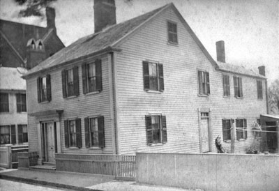
The Lane family was living at what is now 85 Middle Street, Gloucester, Massachusetts when Nathaniel Rogers Lane was born on December 19, 1804, and he continued to reside there until he moved to Boston, as Fitz Henry Lane, around 1832. This house is now gone, replaced by the brick building of the old Gloucester Cooperative Bank. Also in the house had been his father Jonathan Dennison Lane, a sail-maker, who died in 1816; his mother Sarah Haskell Lane and his older brother Edward who lived there until 1839; and his younger sister Sarah Ann Lane who lived there until she married Ignatius Winter in 1834 and moved to Boston.
Fitz Henry's residence in Boston lasted from the early 1830s until his return to Gloucester in 1849, but his home addresses are not established. He had studios at various locations—7 Summer Street, 17 School Street, 16 Tremont Temple, and 28 Joy's Building at 77–85 Washington Street. It is possible that he lived with his sister and her husband and their growing family near Haymarket Square, mostly on the now-lost Friend Street. Ron Polito has established his studio in room 16 of Tremont Temple for the years 1843 to 1850.
When Lane visited Gloucester while living in Boston, he stayed at his family's house on Middle Street until 1839, and then at his mother and brother's house at 179 Washington Street, near the entrance to the Oak Grove Cemetery. He also had a studio on Elm Street, where now a parking lot lies behind the Cape Ann Museum. This accommodation lasted until the stone house on Ivy Court, Duncan's Point, was completed in 1851 and he and the large Winter family moved into it. Fitz Henry lived in the Stone House for the rest of his life. His sister Sarah, her husband Ignatius Winter, and their seven surviving children, lived there also until they were evicted by a bit of legal and real-estate dealing by Lane's friend Joseph L. Stevens. After that, Lane lived in peace with a housekeeper, probably his cousin Mrs. Elizabeth Haskell Galacar and her daughter Allie, from 1862 until August 13, 1865, when he died.
– Sarah Dunlap (June, 2015)
1882
85 Middle Street is Lane's birthplace. In Lane's day the house wouldn't have had the extension in the back.
Also filed under: Chronology »
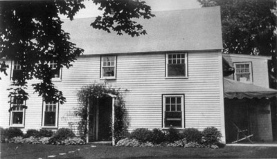
The house at 179 Washington Street, at one time the home of Fitz Henry Lane, was built c. 1700 of plank frame construction.
Also filed under: Chronology »
c.1979
Ivy Court was the name of the street where Lane built his stone house. "A path that became known as Ivy Court ran up the hill to the southeast from Locust Street. Lane built his stone house on top of the hill, along the southwest side of Ivy Court . . ."
From Buck and Dunlop, Fitz Henry Lane: Family and Friends, p. 152.
Also filed under: Chronology » // Lane's Stone House, Duncan's Point »
9.18.1830 Newspaper "Distressing Fire" col. 1 Gloucester Telegraph American Antiquarian Society
A great fire swept through Main St. in Gloucester:
“We have been called to witness the most distressing calamity which has ever visited our citizens. A considerable part of our town is in ruins. On Thursday morning, about 4 o’clock fire was discovered in the house owned and occupied by Samuel Gilbert, in Front Street, and is supposed to have commenced in a building in rear of said house, though the exact spot in which it originated is not accurately known, The flames spread with such rapidity, notwithstanding the calmness of the atmosphere, that no effectual check could be given, until they had destroyed upwards of 20 dwelling houses, together with about 40 stores, mechanic’s shops and other smaller buildings. These were mostly on the south side of the street, and between it and the water. Crossing the street, however, it destroyed several buildings, but was fortunately arrested at the store of Kimball & Hough, by demolishing two small buildings adjoining. It was finally checked by the arrival of assistance from Sandy Bay, Essex, Manchester and Ipswich, the engines from those places rendering the most important services, as without them the greater part of the village must have been consumed. We feel very grateful to the citizens of the above named places as well as to those of Salem, Beverly, Danvers & Marblehead. They set out very promptly at the first information of our distress, but in consequence of the general confusion & anxiety that prevailed, suitable measures were not taken to obtain seasonable aid from the most distant of these towns.
The disaster has fallen upon that part of our town in which the most business was transacted, and the sufferers are among our most active and enterprising citizens. No correct estimate of the losses sustained can, at present be made. – Great praise is due to the citizens generally for their intrepidity and vigorous exertions on this occasion . . . “
Lane was not mentioned by name, but he would have removed his furniture along with others.
Also filed under: Biographical information » // Chronology » // Newspaper / Journal Articles »
1834–35 Lithograph 24 x 38 in. Gloucester City Archives
"Drawn on a scale of one hundred feet to an inch. By John Mason 1834–45 from Actual Survey showing every Lott and building then standing on them giving the actual size of the buildings and width of the streets from the Canal to the head of the Harbour & part of Eastern point as farr as Smith's Cove and the Shore of the same with all the wharfs then in use. Gloucester Harbor 1834–35."
This map shows the location of F. E. Low's wharf and the ropewalk. Duncan's Point, the site where Lane would eventually build his studio, is also marked.
The later notes on the map are believed to be by Mason.
Also filed under: Duncan's Point » // Gloucester Harbor, Inner / Harbor Cove » // Low (Frederick G.) wharves » // Low, Capt. Frederick Gilman » // Maps » // Mason, John » // Ropewalk » // Somes, Capt. John »
1837 9 x 14 in. Cape Ann Museum Library & Archive
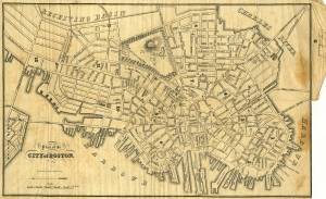
Showing Lane's neighborhood while working in Boston. Lane had studios at the intersection of Washington and State Streets, Summer, Tremont and School Streets.
Also filed under: Boston City Views » // Lane & Scott's, Lith. – Boston » // Maps » // Professional » // Tremont Temple »
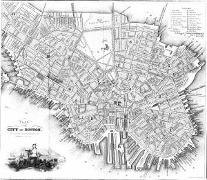
1847 Map insert to Boston Almanac and Directory Cape Ann Museum Library & Archive
Also filed under: Boston City Views » // Maps » // Tremont Temple »
1852 Boston Boston Public Library: Norman B. Leventhal Map Center Call Number: G3764.B6 1852.M35
Also filed under: Boston City Views » // Maps »
1852 Boston Norman B. Leventhal Map Center at Boston Public Library Call Number: G3764.B6 1852.M35
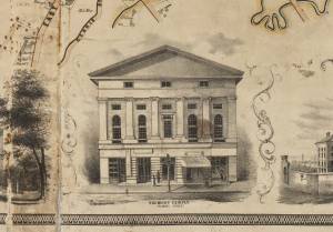
Lane's studio was in the vicinity of the Tremont Temple
Also filed under: Tremont Temple »
1854 Newspaper "Letters on Art. - No. IV"
"In that space [four years] the town has grown greatly . . . a great ugly, yellow "Pavilion" suns itself on the rocks . . . I said there are only two stone buildings in this town of Gloucester: one is "the Bank," the other belongs to Mr. F. H. Lane, whose name ought to be known from Maine to Georgia as the best marine painter in the country.
If Mr. Lane is not as well known as he ought to be, he has at least no reason to complain of neglect or want of appreciation. He has been painting only fifteen years, and his pictures are in great demand; hitherto chiefly among sea-faring men, but now winning way in other circles. In former times I used to be often in Mr. Lane's painting-room, and it was with real pleasure that I found my way to his new house, built from his own design, of native granite, as I mentioned, handsome, peculiar, stable, and commanding a wide sweep of land and ocean from its ample windows. The house is the best that has been built in Gloucester for fifty years. . .
Mr. Lane has put few pictures in his studio at present; for he is very industrious, and sends his canvases off as fast as they are filled. If you were to meet him in the street, you would hardly take him for an artist. A man apparently of forty years, walking with difficulty, supported by crutches, hard-handed, browned by the sun and exposure, with a nose indicating less the artist sensibility than the artist resolution . . .
His early pictures had something in them too hard and practical to permit enthusiastic admiration; the water was salt, the ships sailed, the waves moved, but it was the sea before the Spirit of God moved upon the face of the deep.
His pictures early delighted sailors by their perfect truth. Lane knows the name and place of every rope on a vessel; he knows the construction, the anatomy, the expression – and to a seaman every thing that sails has expression and individuality . . . [Lane] has earned his money thus far mostly by painting "portraits" of vessels for sailors and ship-owners. It is owing to this necessity, perhaps, that he has fallen into the fault of too great literalness of treatment, which I have mentioned as characterizing some of his earlier works; but with the rapid advance he has made in the past four years, there is no longer any fear that he is incapable of treating a subject with genuine imagination . . .
He has indulged in no tricks and no vagaries; he has slighted nothing, despised nothing. If I appear to think less of his early pictures than they deserve, it is not because they are carefully even painfully studied, and because no detail has escaped his eye or brush; it is not that he has too much conscience; but simply because I missed in them the creative imagination of the artist. But it may well be a question whether at this day, when slight and untruthful work prevails, when artists will not paint with conscience, and the public does not strenuously demand it, conscience and love are not higher needs than imagination, and whether Mr. Lane's early pictures, the landmarks on his toilsome, earnest journey to his present place, have not a great value of their own. There is not one of them that I have seen, without some valuable passage, showing acute observation and careful, studious execution.
A sea-piece, "Off the coast of Maine, with Desert-Island in the distance," is the finest picture that Mr. Lane has yet painted. The time is sunset after a storm. The dun and purple clouds roll away to the south-west, the sun sinks in a glory of yellow light, flooding the sea with transparent splendor. Far away in the offing, hiding the sun, sails a brig fully rigged . . . I urged Mr. Lane to send this picture to New-York for exhibition . . ."
Also filed under: Newspaper / Journal Articles » // Pavilion Hotel »
9.1855 Newspaper
"Business Directory Listings"
Artists – Fitz H. Lane, residence on Duncan Street
Addison Center, residence on Washington St.
Also filed under: Center, Addison » // Newspaper / Journal Articles »
"Mr. Fitz H. Lane informs us that he counted on one strawberry plant in his garden, 205 berries. He had several plants which bore 150. We have not heard of any one's going ahead of this – If it has been eclipsed we would like to publish it."
Also filed under: Chronology » // Newspaper / Journal Articles »
1857 Newsprint Courtesy of the American Antiquarian Society, Worcester, Mass.
See p. 1, columns 1 and 2.
"Artists. / Fitz H. Lane, residence on Duncan street. / Addison Center, residence on Washington street. / Alfred J. Wiggin, Annisquam."
Also filed under: Newspaper / Journal Articles » // Procter Brothers » // Professional » // Winter, Ignatius »
Newsprint, various dates, from bound volume owned by publisher Francis Procter. Collection of Fred and Stephanie Buck.
"We saw on Thursday afternoon some full-blown 'ladies' delights,' picked in the open garden of Mr. Fitz H. Lane. they were as bright and beautiful as in their own proper season."
Also filed under: Chronology » // Newspaper / Journal Articles »
6.28.1861 Newsprint Cape Ann Advertiser Collection of Fred and Stephanie Buck
About the two magnolia trees in his garden:
"THE MAGNOLIA SEASON has arrived, and we have been favored with a fine bunch the present week from a friend, who will please accept our hearty thanks. It has been supposed that this fragrant flower could not be transplanted into our gardens and live, but must be confined to the swamps where they originally grow, but this is a mistaken idea, for there are several magnolia trees in town which have been transplanted, and are dowing well. Mr. Fitz H. Lane has two trees in a very flourishing condition in his garden, and the flowers are much larger than those in the wild state; all that is necessary is to keep them well watered, and protect them in winter by covering them with straw. We wonder that there are not more of them cultivated, for certainly they are the most fragrant of all flowers."
Also filed under: Chronology » // Newspaper / Journal Articles »
6.11.1879 Newspaper Cape Ann Bulletin Advertisement for the late Fitz H. Lane's house Cape Ann Museum Library & Archives
Desirable Residence For Sale.
The stone cottage house, on Ivy Hill, Gloucester, built by the late Fitz H. Lane, marine artist, and lately occupied by Capt. F.G. Low, deceased, is to be sold. It commands a fine view of the harbor and city, has a large lot of land well stocked with fruit and ornamental trees and shrubs, and is very near Post Office and Railroad Station, making it a desirable summer or permanent residence. For particulars apply to David W. Low, Gloucester, Mass.
1903 Four-page letter Collection of the Cape Ann Museum Library & Archive, Gloucester, Mass.
"[The painting] is offered you for $150 on as long time and in as many notes at 3% interest as you choose. . . I believe this to be the only important painting of Gloucester Harbor that Lane never duplicated. . . .Returning from a Gloucester visit while I was still under the roof there, father brought a print of Lane's first Gloucester view, bought of the artist at his Tremont Temple studio in Boston. An extra dollar had been paid for coloring it. For a few years it was a home delight.. . .I had been a few years in Gloucester when Lane began to come, for part of the time a while, if I remember rightly. He painted in his brother's house, "up in town" it then was. I recall visits there to see his pictures. But it was long after, that I could claim more than a simple speaking acquaintance. The Stacys were very kind, aiding him as time went on in selling paintings by lot. I invested in a view of Gloucester from Rocky Neck, thus put on sale at the old reading room, irreverently called "Wisdom Hall." And they bought direct of him to some extent, before other residents. Lane was much my senior and yet we gradually drifted together. Our earliest approach to friendship was after his abode began in Elm Street as an occupant of the old Prentiss [sic-corrected Stacy] house, moved there from Pleasant. I was a frequenter of this studio to a considerable extent, yet little compared with my intimacy at the next and last in the new stone house on the hill. Lane's art books and magazines were always at my service and a great inspiration and delight—notably the London Art Journal to which he long subscribed. I have here a little story to tell you. A Castine man came to Gloucester on business that brought the passing of $60 through my hands at 2 1/2 % commission. I bought with the $1.50 thus earned Ruskin's Modern Painters, my first purchase of an artbook. I dare say no other copy was then owned in town. . . .Lane was frequently in Boston, his sales agent being Balch who was at the head of his guild in those days. So in my Boston visits – I was led to Balch's fairly often – the resort of many artists and the depot of their works. Thus through, Lane in various ways I was long in touch with the art world, not only of New England but of New York and Philadelphia. I knew of most picture exhibits and saw many. The coming of the Dusseldorf Gallery to Boston was an event to fix itself in one's memory for all time. What talks of all these things Lane and I had in his studio and by my fireside!
For a long series of years I knew nearly every painting he made. I was with him on several trips to the Maine coast where he did much sketching, and sometimes was was [sic] his chooser of spots and bearer of materials when he sketched in the home neighborhood. Thus there are many paintings whose growth I saw both from brush and pencil. For his physical infirmity prevented his becoming an out-door colorist."
c.1869 Glass plate negative Cape Ann Museum Library & Archive Detail from CAHA#00279
The magnificent views of Gloucester Harbor and the islands from the top floor of the stone house at Duncan's Point where Lane had his studio were the inspiration for many of his paintings.
From Buck and Dunlop, Fitz Henry Lane: Family, and Friends, pp. 59–74.
Also filed under: Duncan's Point » // Gloucester Harbor, Inner / Harbor Cove » // Lane's Stone House, Duncan's Point »
1897
Elm Street looking toward Prospect Street 1897. Gambrel moved from 17 Pleasant Street in 1842 by Harvey Coffin McKay to build his new house. F. H. Lane lived and worked in this Gambrel at 8 Elm Street with his sister and brother-in-law for several years until the stone house on Duncan Street was built in 1850. See Stephanie Buck,Fitz Henry Lane, Family and Friends, p. 51.
2020, Urban Renewal and the Fitz Henry Lane House Online Exhibition, Cape Ann Museum
This online archival exhibition details the survival of Lane's house on Duncan's Point through the efforts of civic leaders during Urban Renewal in Gloucester in the 1950s.
Also filed under: Lane's Stone House, Duncan's Point »
Marks: Inscribed upper left (in red ink): 68 [numbering system used by curator A. M. Brooks upon Samuel H. Mansfield's donation of the drawings to the Cape Ann Museum]