An online project under the direction of the CAPE ANN MUSEUM
Catalogue Entry
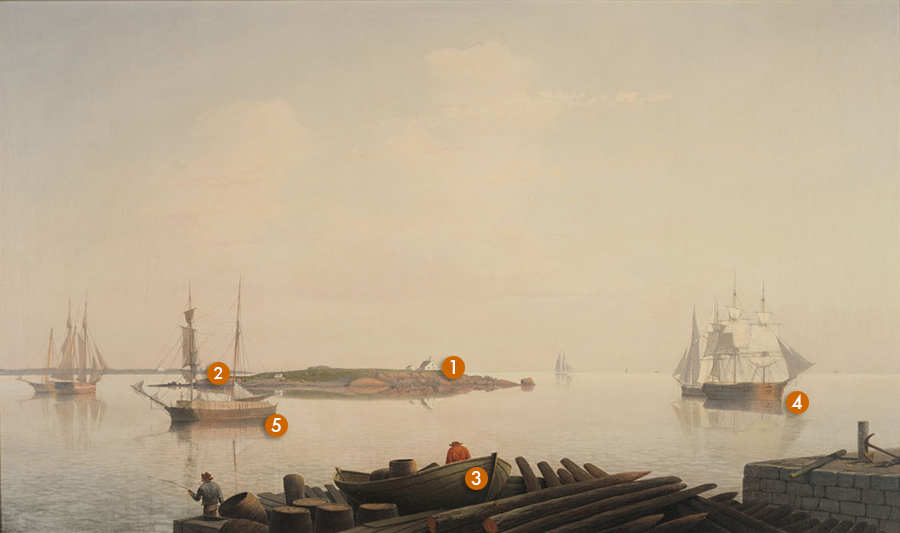
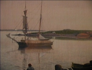
This view of Ten Pound Island in late afternoon light is one of Lane’s harbor views in which the subject matter is as much the light and atmosphere as it is the boats and harbor. Ten Pound Island, Gloucester shows George Rogers’s wharf on Fort Point in the foreground. The stone pier on the right has already been completed and the wooden wharf is still being built. The pilings, looking like sharpened pencils, are laid out ready to be driven into the seabed.
While the true subject matter may be the hazy light of a late summer afternoon, there is much fascinating detail to engage the eye. In Lane’s typically dark foreground there is the pile of sharpened wharf pilings matching the angle of the lumber brig entering the harbor. Note the cluster of barrels with the open-topped one angled to match the fisherman's stance. Both are mirrored by the bowsprit of the lumber brig. An exquisitely drawn double-ended New England boat sits on the wharf. The sweep and bend of the planks running stem to stern and the weight and volume of the hull and its perfect symmetry create an almost-living form. One of Lane’s short-necked men in a red shirt leads the eye out of the deep browns of the foreground arrangement and into the light and open space of the water.
Ten Pound Island, shown in the center of the canvas, marks the entrance to Gloucester’s Inner Harbor and provides a buffer against the strong southerlies blowing into the harbor. The lighthouse was first lit in 1821. In 1880, Winslow Homer spent a summer in the lighthouse keeper’s house and painted fifty of his most masterful watercolors that year, many from the island.
In the distance is Eastern Point, the southeasterly arm of Cape Ann and, barely visible between the masts of the lumber brig, the Eastern Point lighthouse, which marks the entrance to the Outer Harbor. The vessel heading to the left into the harbor is a lumber brig coming down from Maine or Canada with milled wood piled on deck. The three-masted ship to the right was likely a trader with Surinam or other foreign ports.
All the elements of the composition are carefully placed in a zig-zag fashion that was very common to Lane. Starting at the lower left, the eye is taken on a right diagonal along the path of the lumber brig to the three-masted ship, a direction reinforced by the pointing of the pilings on the wharf. At the ship, the eye is led to the left, back to the island and the ship just beyond it. The ship then leads one out diagonally beyond the island, along Eastern Point and out to the open ocean.
The water and sky appear as one vaporous substance in contrast to the dense materiality of the foreground wood and stone.The apricot hues of the late afternoon light touch every surface of boats, sails, island, and cloud and envelop each object in a diffused humidity. Lane’s color values are perfectly tuned within a very narrow range to convey the deep recession of space as the harbor opens out to the ocean. At the horizon line, ocean and sky merge in an almost pure-white band of light; the specks of boats provide just enough information for the eye to comprehend the vastness of the space Lane has conveyed.
– Sam Holdsworth
George H. Rogers’s wharves and vessel activity
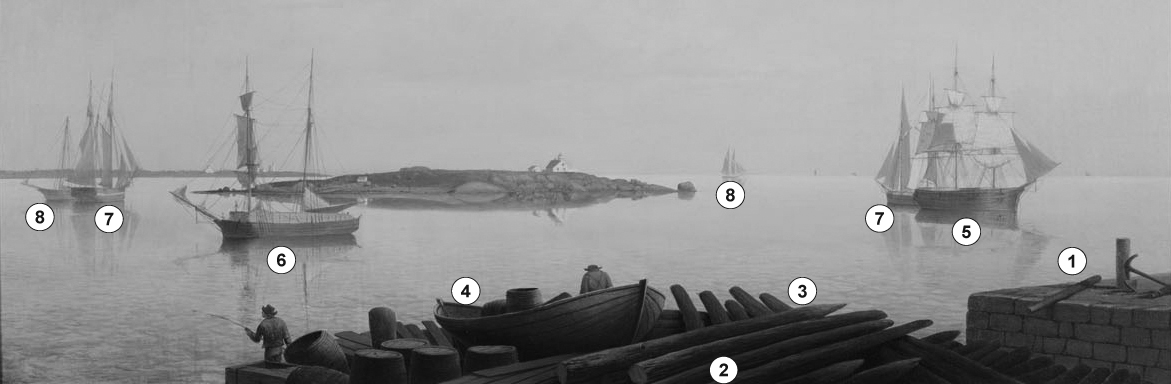
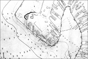
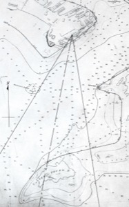
While this painting has been dated to the 1850s (or even to 1849), attempts to match the structures shown in this painting with those on a U.S. Coast Survey chart from that period, proved futile. Only when plotted on a chart prepared for the Gloucester Harbor Commissioners in 1865 could the viewpoint of the painting be aligned with the shape of George H. Rogers's wharves and their placement in relation to Eastern Point and Ten Pound Island. These wharves do not appear on the U.S. Coast Survey chart of 1855, but had been completed by 1865.
Sometime after 1855, George H. Rogers extended a bulkhead pier and by 1864 (as shown in Ten Pound Island in Gloucester Harbor, 1864 (inv. 104)), two finger piers (1 and 3) along the point’s southeast shore line. These were of stone construction, the finger piers jutting into the harbor at angles to keep within the Harbor Commissioner’s Line (see chart detail). At the time Lane made his drawing, one finger pier (3) was covered with lumber, possibly for a deck over the stonework. In his painting, the same wharf is covered with pilings—called “spiles” by Gloucester mariners. A double-ended New England boat (4) sits among them without a clue to how it got there. At least one “wharf rat” has found his way onto the pier to fish for his supper, while another surveys the scene from his perch in the New England boat.
The piers are notable for their stone work. Unlike their predecessors of cob wharf construction, their stone blocks are quarried granite, carefully shaped and fitted, with no jagged sides or irregular joiner work. This was probably the first wharf (actually a complex of wharves) in Gloucester Harbor to use quarried stone and careful joinery.
George H. Rogers was a major figure in Gloucester’s foreign trade, particularly that with Surinam. This wharf complex was his response to the employment of ever-larger ships in maritime commerce and the problems a shallow harbor posed for berthing them. Jutting out into deeper water, the wharf gave Rogers’ ships better loading accommodations and faster turnaround time, but not for much longer. Even these wharves were in water too shallow for ever-larger vessels, forcing Rogers to join other Gloucester merchants who had moved their businesses to Boston and its deeper harbor. This exodus marked a turnaround for the town’s fishing fleet, which soon reoccupied Harbor Cove. Improvements in fishing technology, and the arrival of immigrants who manned the vessels, restored the port to its dominance of the New England fisheries.
Looking south to the Outer Harbor, we see examples of vessels which typified this period of transition. The full-rigged ship (5) was the vessel type that was coming to dominate the Surinam Trade—at least triple the tonnage of the earlier Surinam brigs like “Cadet" Brig "Cadet" in Gloucester Harbor, late 1840s (inv. 13). The half-brig (6)—a “lumber brig” in this case—enters port with her hold and deck piled high with milled boards—a sign of building activity for both business and housing. Two coasting schooners (7) also hint at needs for business and domestic goods as the town’s population grew from 7,786 to 10,904 between 1850 and 1860. Two schooners (8) are probably fishermen, their low profile suggesting that the fisheries were then just beginning their return to former prosperity.
– Erik Ronnberg
Key to vessels

- Subject Types
: - Vessel Types
: - Cape Ann Locales
: - Activities of People
: - Objects
: - Building Types
:
Historical Materials
George H. Rogers was one of Gloucester's most enterprising citizens of the mid-nineteenth century. In the early 1830s, he ventured into the Surinam trade with great success, leading him to acquire a wharf at the foot of Sea Street. Due to Harbor Cove's shallow bottom at low tide, berthings at wharves had to be done at high tide, leaving the ships grounded at other times. Many deep-loaded vessels had to anchor outside Harbor cove and be partially off-loaded by "lighters" (shallow-draft vessels that could transfer cargo to the wharves) before final unloading at wharfside. To lessen this problem, Rogers had an unattached extension built out from his wharf into deeper water (see The Fort and Ten Pound Island, Gloucester (Harbor Scene), 1848 (inv. 58), right middle ground). The space between the old wharf and the extension may have been a way to evade harbor regulations limiting how far a pier head could extend into the harbor. Stricter rules were not long in coming after this happened!
About 1848, Rogers acquired land on the east end of Fort Point, first putting up a large three-story building adjacent to Fort Defiance, then a very large wharf jutting out into Harbor Cove. Lane's depictions of Harbor Cove and Fort Point show progress of this construction in 1848 (The Fort and Ten Pound Island, Gloucester (Harbor Scene), 1848 (inv. 58)), 1850 (Gloucester Inner Harbor, 1850 (inv. 240)), and c.1851 (Gloucester Harbor at Dusk, c.1852 (inv. 563)). A corner of the new wharf under construction can also be seen more closely in Ten Pound Island, Gloucester, 1850s (inv. 17) and Ten Pound Island in Gloucester Harbor, 1864 (inv. 104) (foregrounds). This new wharf provided better frontage for large ships to load and unload, as well as larger warehouses and lofts for storage of goods and vessel gear.
By 1860, Rogers was unloading his Surinam cargos at Boston, as ever-larger ships and barks were more easily berthed there. His Gloucester wharves continued to be used for deliveries of trade goods by smaller vessels. In the late 1860s, Rogers' wharf at Fort Point (called "Fort Wharf" in Gloucester directories) was acquired by (Charles D.) Pettingill & (Nehemiah) Cunningham for use in "the fisheries" as listed by the directory. in 1876, it was sold to (John J.) Stanwood & Company, also for use in "the fisheries." (1)
Lowe's Wharf, adjacent to Fort Wharf, was acquired by (Sylvester) Cunningham & (William) Thompson, c.1877 and used in "the fisheries" as well. That wharf and its buildings were enlarged considerably as the business grew. By this time, Harbor Cove was completely occupied by businesses in the fisheries or providing services and equipment to the fishing fleet. In photographs of Fort Point from this period, it is difficult to distinguish one business from another, so closely are they adjoined.
– Erik Ronnberg
Reference:
1. A city atlas, dated 1899, indicates that Rogers's wharf at Fort Point was still listed as part of his estate. If so, then Stanwood & Co. would have been leasing that facility from the Rogers's estate.
44 x 34 in.
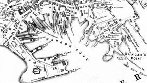
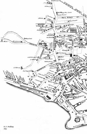
Henry Francis Walling, Map of the Towns of Gloucester and Rockport, Essex Co. Massachusetts. Philadelphia, A. Kollner, 1851
Cape Ann Museum Library & Archive
"Map of the Towns of Gloucester and Rockport, Massachusetts. H.F. Walling, Civil Engineer. John Hanson, Publisher. 1851. Population of Gloucester in 1850 7,805. Population of Rockport in 1850 3,213."
Segment of Harbor Village portion of map showing Low's, Rogers', and other wharves in the Inner Harbor.
Also filed under: Low (Frederick G.) wharves »
44 x 34 in.
Henry Francis Walling, Map of the Towns of Gloucester and Rockport, Essex Co. Massachusetts. Philadelphia, A. Kollner, 1851
Cape Ann Museum Library & Archive
"Map of the Towns of Gloucester and Rockport, Massachusetts. H.F. Walling, Civil Engineer. John Hanson, Publisher. 1851. Population of Gloucester in 1850 7,805. Population of Rockport in 1850 3,213."

44 x 34 in.
John Hanson, Publisher
Cape Ann Museum Library & Archive
"Map of the Towns of Gloucester and Rockport, Massachusetts. H.F. Walling, Civil Engineer. John Hanson, Publisher. 1851. Population of Gloucester in 1850 7,805. Population of Rockport in 1850 3,213."
Also filed under: Fort (The) and Fort Point » // Low (Frederick G.) wharves » // Maps » // Town / Public Landings » // Waterfront, Gloucester » // Windmill »

1865 41 x 29 inches Courtesy of the Massachusetts Archives Maps and Plans, Third Series Maps, v.66:p.1, no. 2352, SC1/series 50X
.
Also filed under: Burnham Brothers Marine Railway » // Collins's, William (estate wharf) » // Gloucester Harbor, Inner / Harbor Cove » // Maps »

1876 Photograph Cape Ann Museum Library & Archive
Ignatius Weber's windmill (now defunct) is shown.
Also filed under: Flake Yard » // Fort (The) and Fort Point » // Gloucester Harbor, Inner / Harbor Cove » // Historic Photographs » // Schooner (Fishing) » // Waterfront, Gloucester » // Windmill »
Gloucester Outer Harbor served as a staging area for deep draft or heavily laden vessels waiting to come into the wharves in the shallow Old Harbor at high tide, or waiting to discharge cargo into smaller vessels. While Lane's paintings typically show one or two vessels in the harbor, works by other artists from the period, as well as contemporary descriptions, demonstrate that the harbor was usually crowded with vessels, especially in bad weather. The Outer Harbor could accommodate as many as three hundred vessels when they needed to shelter during a storm.
There were two deep spots where they could wait, the "Deep Hole" between Ten Pound Island and the Fort; and the "Pancake Grounds" between Ten Pound Island and Eastern Point. The "Pancake Grounds" also served as a quarantine area for ships arriving from foreign ports. "Deep Hole" was named for the (relatively) deep water between Rocky Neck and Fort Point to the Outer Harbor. Deeply loaded vessels had to anchor there for “lightering” (partial unloading by boats called “lighters”) prior to final unloading at wharfside. "Deep Hole" was 20–25 feet deep at low tide, when Harbor Cove was only 1–6 feet deep with bare ground around some wharves. "Deep Hole" is where you see ships anchored in Gloucester Harbor from Rocky Neck, 1844 (inv. 14), The Old Fort and Ten Pound Island, Gloucester, 1850s (inv. 30), , Gloucester Inner Harbor, 1850 (inv. 240), The Fort and Ten Pound Island, Gloucester, Massachusetts, 1847 (inv. 271), and Gloucester Harbor, 1848 (inv. 335) (which is coming to anchor).
The term "Deep Hole" is apparently a post-Bellum term. Prior to that, it was known as "The Stream" and, as later, served as anchorage where deeply loaded vessels could be lightered prior to docking in Harbor Cove. Alfred Mansfield Brooks in his book Gloucester Recollected uses this term on page 53. After the Civil War, merchant shipping in Gloucester was dominated by salt ships and later coal carriers, bringing a whole new culture to the harbor, and with it new names for old places.

John Heywood Photo for Hervey Friend
Cape Ann Museum Library & Archive (2013.068)
Schooners anchored on the Pancake Ground, taken from from Wonson's Cove, easterly side of the Rocky Neck causeway. Eastern Point Fort and garrison in background to far left.
Also filed under: Eastern Point »

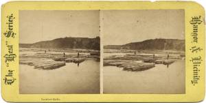
c.1870 Stereograph card Procter Brothers, Publisher Cape Ann Museum Library & Archive
"Gloucester Harbor from Rocky Neck, Looking Southwest. This gives a portion of the Harbor lying between Ten Pound Island and Eastern Point. At the time of taking this picture the wind was from the northeast, and a large fleet of fishing and other vessels were in the harbor. In the range of the picture about one hundred vessels were at anchor. In the small Cove in the foreground quite a number of dories are moored. Eastern Point appears on the left in the background."
Southeast Harbor was known for being a safe harbor.
Also filed under: Historic Photographs » // Rocky Neck » // Schooner (Fishing) » // Small Craft – Wherries, and Dories »

Collection of Erik Ronnberg
View related catalogue entries (2) »
Also filed under: Dolliver's Neck » // Fresh Water Cove » // Gloucester Harbor, Inner / Harbor Cove » // Maps »

c.1870 Stereograph card Procter Brothers, Publisher Cape Ann Museum Library & Archive
View from Civil War fort on Eastern Point.
Also filed under: Eastern Point » // Historic Photographs »


44 x 34 in.
Henry Francis Walling, Map of the Towns of Gloucester and Rockport, Essex Co. Massachusetts. Philadelphia, A. Kollner, 1851
Cape Ann Museum Library & Archive
"Map of the Towns of Gloucester and Rockport, Massachusetts. H.F. Walling, Civil Engineer. John Hanson, Publisher. 1851. Population of Gloucester in 1850: 7,805. Population of Rockport in 1850: 3,213."
Also filed under: Annisquam River » // Brookbank » // Dolliver's Neck » // Fresh Water Cove » // Maps » // Norman's Woe » // Stage Rocks / Stage Fort / Stage Head » // Steepbank » // West Gloucester – Little River » // Western Shore »
Newsprint
Cape Ann Advertiser
Cape Ann Museum Library & Archive
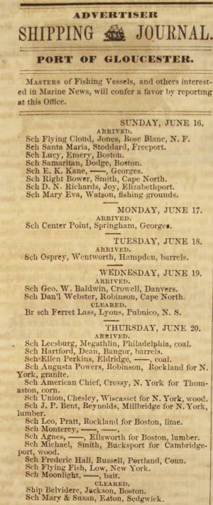
Notice in the Cape Ann Advertiser announcing arrival of ships into the port of Gloucester, with details of their cargo.
Also filed under: Newspaper / Journal Articles » // Trade Routes and Statistics »
Newspaper
"Lane's studio seldom presents so many attractions to visitors as at the present time. With unwonted rapidity his easel has turned off pictures in answer to the numerous orders which have poured in from all quarters."
Also filed under: Chronology » // Newspaper / Journal Articles » // Studio Descriptions »
Electrotype impression
Collection of Erik Ronnberg
Also filed under: Gloucester Harbor, Inner / Harbor Cove » // Maps »

c.1870 Stereograph card Procter Brothers, Publisher Cape Ann Museum Library & Archive
Also filed under: Historic Photographs » // Stage Rocks / Stage Fort / Stage Head »

Pencil and ink on paper
15 x 22 1/8 in.
Cape Ann Museum, Gloucester, Mass., Gift of Mr. Donald K. Usher, in memory of Mrs. Margaret Campbell Usher, 1984 (2401.19)
Also filed under: Beacons / Monuments / Spindles » // Mackerel Fishing »

Watercolor on paper
8 3/4 x 19 3/4 in.
Cape Ann Museum, Gloucester, Mass., Gift of Rev. and Mrs. A. A. Madsen, 1950
Accession # 1468
Fishing schooners in Gloucester's outer harbor, probably riding out bad weather.
Also filed under: Elwell, D. Jerome » // Schooner (Fishing) »
Ten Pound Island guards the entrance to Gloucester’s Inner Harbor and provides a crucial block to heavy seas running southerly down the Outer Harbor from the open ocean beyond. The rocky island and its welcoming lighthouse is seen, passed, and possibly blessed by every mariner entering the safety of Gloucester’s Inner Harbor after outrunning a storm at sea. Ten Pound Island is situated such that the Inner Harbor is protected from open water on all sides making it one of the safest harbors in all New England.
Legend has it that the island was named for the ten pound sum paid to the Indians for the island, and the smaller Five Pound Island deeper in the Inner Harbor was purchased for that lesser sum. None of it makes much financial sense when the entirety of Cape Ann was purchased for only seven pounds from the Indian Samuel English, grandson of Masshanomett the Sagamore of Agawam in 1700. From approximately 1640 on the island was used to hold rams, and anyone putting female sheep on the island was fined. Gloucester historian Joseph Garland has posited that the name actually came from the number of sheep pens it held, or pounds as they were called, and the smaller Five Pound Island was similarly named.
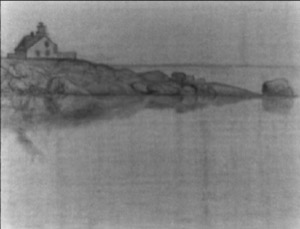
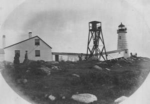
The island itself is only a few acres of rock and struggling vegetation but is central to the marine life of the harbor as it defines the eastern edge of the deep channel used to turn the corner and enter the Inner Harbor. The first lighthouse was lit there in 1821, and a house was built for the keeper adjacent to the lighthouse.
In the summer of 1880 Winslow Homer boarded with the lighthouse keeper and painted some of his most masterful and evocative watercolor views of the busy harbor life swirling about the island at all times of day. Boys rowing dories, schooners tacking in and out in all weather, pleasure craft drifting in becalmed water, seen together they tell a Gloucester story of light, water and sail much as Lane’s work did only several decades earlier.

Colored lithograph
Cape Ann Museum Library and Archive
Also filed under: Gloucester, Mass. - "Ten Pound Island Light »

Photograph
From The Illustrated Coast Pilot with Sailing Directions. The Coast of New England from New York to Eastport, Maine including Bays and Harbors, N. L. Stebbins, 1891.
Also filed under: Gloucester, Mass. - "Ten Pound Island Light »


Oil on canvas
22 x 36 in.
Cape Ann Museum, Gloucester, Mass., deposited by the Collection of Addison Gilbert Hospital, 1978 (DEP. 201)
Detail of party boat.
Also filed under: Party Boat »

Engraving of 1819 survey taken from American Coast Pilot 14th edition
9 1/2 x 8 in.
Cape Ann Museum Library & Archive
D32 FF5
Also filed under: Dolliver's Neck » // Eastern Point » // Maps » // Norman's Woe »
Newspaper
Gloucester Telegraph
"By the will of the late Fitz H. Lane, Esq., his handsome painting of the Old Fort, Ten Pound Island, etc., now on exhibition at the rooms of the Gloucester Maritime Insurance Co., was given to the town... It will occupy its present position until the town has a suitable place to receive it."

Stereograph card
Cape Ann Museum Library & Archive
View from top of Unitarian Church on Middle Street looking southeast, showing the Fort and Ten Pound Island. Tappan Block and Main Street buildings between Center and Hancock in foreground.
Also filed under: Fort (The) and Fort Point » // Unitarian Church / First Parish Church (Middle Street) »

1860 In John J. Babson, History of the Town Gloucester (Gloucester, MA: Procter Brothers, 1860) Cape Ann Museum Library & Archives, Gloucester, Mass.
See p. 474.
View related catalogue entries (4) »
Also filed under: Babson History of the Town of Gloucester » // Chebacco Boat / Dogbody / Pinky » // Fort (The) and Fort Point » // Gloucester Harbor, Inner / Harbor Cove » // Gloucester, Mass. - "Ten Pound Island Light » // Schooner (Coasting / Lumber / Topsail / Packet / Marsh Hay) »
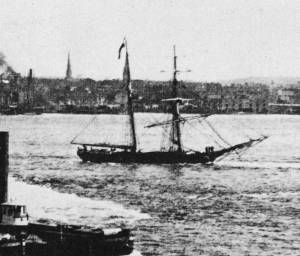
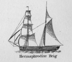
Hermaphrodite brigs—more commonly called half-brigs by American seamen and merchants—were square-rigged only on the fore mast, the main mast being rigged with a spanker and a gaff-topsail. Staysails were often set between the fore and main masts, there being no gaff-rigged sail on the fore mast. (1)
The half-brig was the most common brig type used in the coasting trade and appears often in Lane’s coastal and harbor scenes. The type was further identified by the cargo it carried, if it was conspicuously limited to a specialized trade. Lumber brigs (see Shipping in Down East Waters, 1854 (inv. 212) and View of Southwest Harbor, Maine: Entrance to Somes Sound, 1852 (inv. 260)) and hay brigs (see Lighthouse at Camden, Maine, 1851 (inv. 320)) were recognizable by their conspicuous deck loads. Whaling brigs were easily distinguished by their whaleboats carried on side davits (see ). (2)
– Erik Ronnberg
References:
1. M.H. Parry, et al., Aaak to Zumbra: A Dictionary of the World's Watercraft Newport News, VA: The Mariners’ Museum, 2000), 268, 274; and A Naval Encyclopaedia (L.R. Hamersly & Co., 1884. Reprint: Detroit, MI: Gale Research Company, 1971), 93, under "Brig-schooner."
2. W.H. Bunting, An Eye for the Coast (Gardiner, ME: Tilbury House: 1998), 52–54, 68–69; and W.H. Bunting, A Day's Work, part 1 (Gardiner, ME: Tilbury House: 1997), 52.

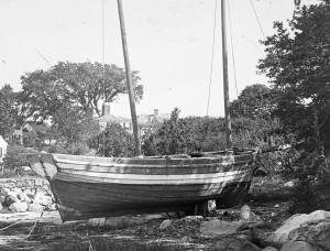
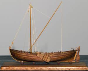
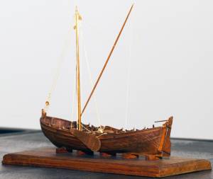
The colonial American shallop is the ancestor of many regional types of New England fishing craft found in Lane's paintings and drawings, including "New England Boats" (known as "boats"), and later descendents, such as "Chebacco Boats," "Dogbodies," and "Pinkies." (discussed elsewhere)
These boats were very common work boat types on Cape Ann throughout the 1800s. They were primarily used for inshore coastal fishing, which included lobstering, gill-netting, fish-trapping, hand-lining, and the like. They were usually sailed by one or two men, sometimes with a boy, and could be rowed as well as sailed. An ordinary catch would include rock cod, flounder, fluke, dabs, or other small flat fish. The catch would be eaten fresh, or salted and stored for later consumption, or used as bait fish. Gill-netting would catch herring and alewives when spawning. Wooden lobster traps were marked with buoys much as they are today, and hauled over the low sides of the boat, emptied of lobsters and any by-catch, re-baited and thrown back.
THE SHALLOP
Like other colonial vessel types, shallops were defined in many ways, including size, construction, and rig. Most commonly, they were open boats with square or sharp sterns, 20 to 30 feet in length, two-masted rigs, and heavy sawnframe construction which in time became lighter. (1)
The smaller shallops developed into a type called the Hampton Boat early in the nineteenth century, becoming the earliest named regional variant of what is now collectively termed the New England Boat. Other variants were named for their regions of origin: Isles of Shoals Boat, Casco Bay Boat, No Mans Land Boat, to name a few. No regional name for a Cape Ann version has survived, and "boat," or "two-masted boat" seems to have sufficed. (2)
Gloucester's New England Boats were mostly double-enders (sharp sterns) ranging in length from 25 to 30 feet, with two masts and two sails (no bowsprit or jib). They were used in the shore fisheries: handlining, gillnetting, and gathering or trapping shellfish (see View from Kettle Cove, Manchester-by-the-Sea, 1847 (inv. 94), View of Gloucester Harbor, 1848 (inv. 97), and /entry: 240/). (3)
Larger, double-ended shallops became decked and evolved in Ipswich (the part now called Essex) to become Chebacco Boats. (4) This variant retained the two-mast, two-sail rig, but evolved further, acquiring a bowsprit and jib and becoming known as a pinky (see Gloucester Harbor from Rocky Neck, 1844 (inv. 14), The Western Shore with Norman's Woe, 1862 (inv. 18), and The Old Fort and Ten Pound Island, Gloucester, 1850s (inv. 30)). The Chebacco Boat became a distinct type by the mid-eighteenth century giving rise to the pinky in the early ninetennth century; the latter, by the early 1900s. (5)
References:
1. William A. Baker, Sloops & Shallops (Barre, MA: Barre Publishing Co., 1966), 27–33; and “Vessel Types of Colonial Massachusetts,” in Seafaring in Colonial Massachusetts (Boston: The Colonial Society of Massachusetts, 1980), 13–15, see figs. 10, 11.
2. Howard I. Chapelle, American Small Sailing Craft (New York: W.W. Norton & Co., 1951), 136–45.
3. Ibid., 145, upper photo, fourth page of plates.
4. Baker, 82–91.
5. Chapelle, The American Fishing Schooners, 1825–1935 (New York: W.W. Norton & Co., 1973), 23–54.
THE NEW ENGLAND BOAT
By the 1840s, the Gloucester version of the New England Boat had evolved into a distinct regional type. Referred to locally as “boats,” the most common version was a double-ender, i.e. having a pointed stern, unlike the less common version having a square stern.
Both variants had two masts, a foresail, a mainsail, but no bowsprit or jib. Lane depicted both in several paintings, beginning in the mid-1840s (see View from Kettle Cove, Manchester-by-the-Sea, 1847 (inv. 94), View of Gloucester Harbor, 1848 (inv. 97), and /entry: 240/), all ranging 25 to 30 feet in length. In View of Gloucester Harbor, 1848 (inv. 97) and Gloucester Inner Harbor, 1850 (inv. 240), a double-ender can be seen on the beach while a square-stern version lies at anchor in the harbor, just to the right of the former. (1)
Lane’s depictions of the double-enders show lapstrake hull planking in View of Gloucester Harbor, 1848 (inv. 97) and Gloucester Inner Harbor, 1850 (inv. 240), and cuddies (short decking) inboard at the ends for shelter and stowage of fishing gear in View from Kettle Cove, Manchester-by-the-Sea, 1847 (inv. 94). The few square-stern examples (see View of Gloucester Harbor, 1848 (inv. 97) and Gloucester Inner Harbor, 1850 (inv. 240)) suggest carvel (smooth) planking and paint finish, rather than oil and tar. The presence of an example of the latter variant in Boston Harbor, as noted in Boston Harbor, c.1850 (inv. 48), suggests a broader geographical range for this subtype. (2)
The primary use of Cape Ann’s “boats” was fishing, making “day trips” to coastal grounds for cod, herring, mackerel, hake, flounder, and lobster, depending on the season. Fishing gear included hooks and lines, gill nets, and various traps made of wood and fish net.
Some boats worked out of Gloucester Harbor, but other communities on Cape Ann had larger fleets, such as Sandy Bay, Pigeon Cove, Folly Cove, Lanesville, Bay View, and Annisquam. Lane’s depictions of these places and their boats are rare to nonexistent. (3)
The double-ended boat served Lane in marking the passage of time in Gloucester Harbor. In View from Kettle Cove, Manchester-by-the-Sea, 1847 (inv. 94), we see new boats setting out to fish, but in View of Gloucester Harbor, 1848 (inv. 97) and Gloucester Inner Harbor, 1850 (inv. 240), a boat of the same type is depicted in a progressively worn state. In Stage Fort across Gloucester Harbor, 1862 (inv. 237), the boat is a stove hulk on a beach, and in the same year, Lane depicted the type’s shattered bottom frame and planking lying on the shore at Norman’s Woe in Norman's Woe, Gloucester Harbor, 1862 (inv. 1).
Regional variants of the New England Boat appear in Lane’s paintings of Maine harbors, including one and two-masted versions, collectively called Hampton Boats (see Bear Island, Northeast Harbor, 1855 (inv. 24), Ten Pound Island at Sunset, 1851 (inv. 25), Fishing Party, 1850 (inv. 50), Father's (Steven's) Old Boat, 1851 (inv. 190), and "General Gates" at Anchor off Our Encampment at Bar Island in Somes Sound, Mount Desert, Maine, 1850 (inv. 192)). Some distinctive regional types were given names, i.e. Casco Bay Boats ("General Gates" at Anchor off Our Encampment at Bar Island in Somes Sound, Mount Desert, Maine, 1850 (inv. 192) may be one), but many local type names, if they were coined, have been lost. (4)
References:
1. Howard I. Chapelle, American Small Sailing Craft (New York: W.W. Norton & Co., 1951), 141–42.
2. Ibid., 152–55.
3. Sylvanus Smith, Fisheries of Cape Ann (Gloucester, MA: Press of the Gloucester Times, 1915), 96–97, 102–05, 110–13.
4. Chapelle, 152–55.
Also filed under: Ship Models »
Also filed under: Ship Models »
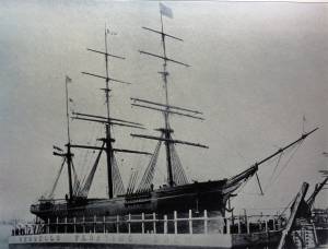
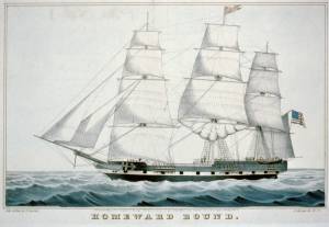
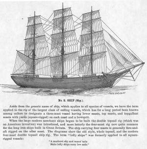
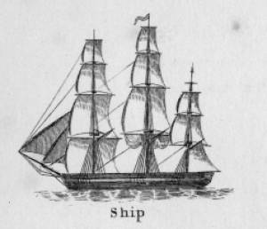
The term "ship," as used by nineteenth-century merchants and seamen, referred to a large three-masted sailing vessel which was square-rigged on all three masts. (1) In that same period, sailing warships of the largest classes were also called ships, or more formally, ships of the line, their size qualifying them to engage the enemy in a line of battle. (2) In the second half of the nineteenth century, as sailing vessels were replaced by engine-powered vessels, the term ship was applied to any large vessel, regardless of propulsion or use. (3)
Ships were often further defined by their specialized uses or modifications, clipper ships and packet ships being the most noted examples. Built for speed, clipper ships were employed in carrying high-value or perishable goods over long distances. (4) Lane painted formal portraits of clipper ships for their owners, as well as generic examples for his port paintings. (5)
Packet ships were designed for carrying capacity which required some sacrifice in speed while still being able to make scheduled passages within a reasonable time frame between regular destinations. In the packet trade with European ports, mail, passengers, and bulk cargos such as cotton, textiles, and farm produce made the eastward passages. Mail, passengers (usually in much larger numbers), and finished wares were the usual cargos for return trips. (6) Lane depicted these vessels in portraits for their owners, and in his port scenes of Boston and New York Harbors.
Ships in specific trades were often identified by their cargos: salt ships which brought salt to Gloucester for curing dried fish; tea clippers in the China Trade; coffee ships in the West Indies and South American trades, and cotton ships bringing cotton to mills in New England or to European ports. Some trades were identified by the special destination of a ship’s regular voyages; hence Gloucester vessels in the trade with Surinam were identified as Surinam ships (or barks, or brigs, depending on their rigs). In Lane’s Gloucester Harbor scenes, there are likely (though not identifiable) examples of Surinam ships, but only the ship "California" in his depiction of the Burnham marine railway in Gloucester (see Three Master on the Gloucester Railways, 1857 (inv. 29)) is so identified. (7)
– Erik Ronnberg
References:
1. R[ichard)] H[enry] Dana, Jr., The Seaman’s Friend, 13th ed. (Boston: Thomas Groom & Co., 1873), p. 121 and Plate IV with captions.
2. A Naval Encyclopaedia (Philadelphia: L. R. Hamersly & Co., 1884), 739, 741.
3. M.H. Parry, et al., Aak to Zumbra: A Dictionary of the World’s Watercraft (Newport News, VA: The Mariners’ Museum, 2000), 536.
4. Howard I. Chapelle, The History of American Sailing Ships (New York: W.W. Norton & Co., 1935), 281–87.
5. Ibid.
6. Howard I. Chapelle, The National Watercraft Collection (Washington, DC: Smithsonian Institution, 1960), 26–30.
7. Alfred Mansfield Brooks, Gloucester Recollected: A Familiar History (Gloucester, MA: Peter Smith, 1974), 67–69.
Photograph
From American Clipper Ships 1833–1858, by Octavius T. Howe and Frederick C. Matthews, vol. 1 (Salem, MA: Marine Research Society, 1926).
Photo caption reads: "'Golden State' 1363 tons, built at New York, in 1852. From a photograph showing her in dock at Quebec in 1884."
Also filed under: "Golden State" (Clipper Ship) »
_sm.jpg)

Oil on canvas
24 x 35 in.
Peabody Essex Museum, Salem, Mass.
Walters' painting depicts the "Nonantum" homeward bound for Boston from Liverpool in 1842. The paddle-steamer is one of the four Clyde-built Britannia-class vessels, of which one is visible crossing in the opposite direction.
View related catalogue entries (2) »
Also filed under: Packet Shipping » // Walters, Samuel »
The Ten Pound Island light was built on a three-and-a-half acre island at the eastern end of Gloucester Harbor. Built as a conical stone tower, the original 20-foot-tall Ten Pound Island Light was first lit in October, 1821 after the Commonwealth of Massachusetts and the Town of Gloucester ceded 1.7 acres to the U.S. Government for the construction of an inner harbor lighthouse to help mariners navigate the harbor. Ten Pound Island light was a popular subject with artists, including Winslow Homer, who boarded with the lighthouse keeper at Ten Pound Island in the summer of 1880. It is frequently featured in Lane's paintings of Gloucester Harbor.
This information has been shared with the Lane project by Jeremy D'Entremont. More information can be found at his website, www.newenglandlighthouses.net or in The Lighthouse Handbook New England. This information has also been summarized from Paul St. Germain's book, Lighthouses and Lifesaving Stations on Cape Ann.

Colored lithograph
Cape Ann Museum Library and Archive
Also filed under: Ten Pound Island »
Photograph
From The Illustrated Coast Pilot with Sailing Directions. The Coast of New England from New York to Eastport, Maine including Bays and Harbors, N. L. Stebbins, 1891.
Also filed under: Ten Pound Island »

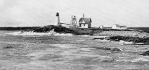
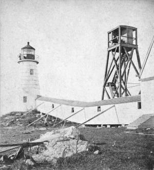
The Eastern Point Light is located in the town of Gloucester, Massachusetts on the east side of the entrance to Gloucester Harbor. In 1829, an unlit stone beacon was erected on Eastern Point to help mariners navigating Gloucester Harbor. Shortly thereafter, in 1832, a wrought-iron and copper lantern was added to the stone tower, and the first Eastern Point Light was born. During the 1840s, Gloucester became one of the most important fishing ports in America, and to cope with the increased fishing traffic, a new Eastern Point Light was built in 1848. The new 34 foot tower gained the nickname "The Ruby Light" due to its unique fixed red light. The Eastern Point Light was further improved upon in the following decades with the addition of a fourth-order Fresnel lens and fog bell.
This information has been shared with the Lane project by Jeremy D'Entremont. More information can be found at his website, www.newenglandlighthouses.net or in The Lighthouse Handbook New England. This information has also been summarized from Paul St. Germain's book, Lighthouses and Lifesaving Stations on Cape Ann.
Photograph U.S. Coastguard
For over 100 years the fishermen of Gloucester have been guided back to their home port by a lighthouse on Eastern Point. The present brick tower, painted a gleaming white, and standing on the long rocky point forming the eastern side of the harbor, was built in 1890, replacing on the same foundation the original tower built in 1832. Before 1832 a still older lighthouse, on Ten-Pound Island well inside of the harbor, had served as an entrance light, but this light was never visible until ships had actually found the entrance, hence the building of a lighthouse on the Eastern Point where it could be seen from far offshore.
Courtesy United States Coast Guard.
Also filed under: Historic Photographs »
Newspaper
"There are quite a number of visitors in town at the present time, who come to spend a few weeks by the seaside, during the sultry weather of August."
Also filed under: Fessenden, C. B. » // Newspaper / Journal Articles » // Procter Brothers – Gloucester, Mass. » // Tourist Industry »
Newspaper clipping
Cape Ann Advertiser
Collection of Fred and Stephanie Buck
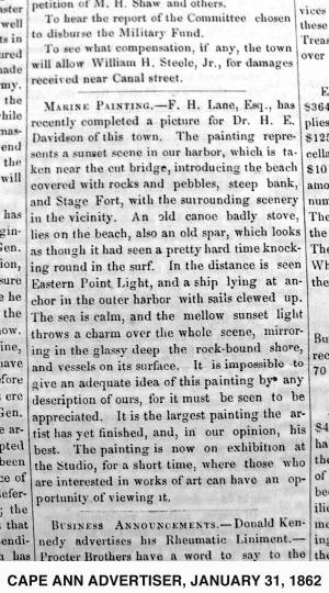
"MARINE PAINTING. – F. H. Lane, Esq., has recently completed a picture for Dr. H. E. Davidson of this town. The painting represents a sunset scene in our harbor, which is taken near the cut bridge, introducing the beach covered with rocks and pebbles, steep bank, and Stage Fort, with the surrounding scenery in the vicinity. . . It is impossible to give an adequate idea of this painting by any description of ours, for it must be seen to be appreciated. It is the largest painting the artist has yet finished, and, in our opinion, his best. The painting is now on exhibition at the Studio, for a short time, where those who are interested in works of art can have an opportunity of viewing it."
Also filed under: Davidson, Dr. Herman Elvas » // Newspaper / Journal Articles » // Studio Descriptions »
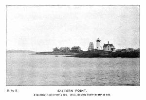
Plate from The Illustrated Coast Pilot with Sailing Directions: The Coast of New England from New York to Eastport, Maine including Bays and Harbors, published by N. L. Stebbins,1896.
Also filed under: Eastern Point »
Stereograph card
Published by Frank Rowell
Cape Ann Museum Library & Archive
Also filed under: Eastern Point »
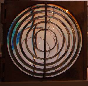
Four circular glass prism lenses in a brass frame:
Lens diameters 19". Base 21" square x 19-1/2" high.
Cape Ann Museum. On permanent loan from the United States Coast Guard, 2013
When installed, the light source was fixed and the lens mount rotated.
Also filed under: Objects »
The timber trade played an important role in New England’s economy from Colonial days through the mid-19th century, supplying the vast quantities of lumber which a rapidly growing nation demanded. While Cape Ann’s woodlands were depleted early on, timber continued to be harvested from northern New England and the Maritime Provinces right up to the Civil War.
With a deep and safe harbor, Gloucester often served as a layover spot where vessels bound from Maine to Boston, New York or Baltimore and heavily laden with lumber could ride out bad weather. Because of this, Fitz Henry Lane’s paintings of Gloucester Harbor often show a schooner or a brig, loads of lumber clearly visible on their decks, sheltering along the Western Shore.
References:
Honey, Mark E., "King Pine, Queen Spruce, Jack Tar," An Intimate History of Lumbering on the Union River, Volumes 1-5. This source, in its entirety, lays down the foundation of Downeast Maine's unique culture which was built upon pine lumber and timber, the cod fisheries, coasting, shipbuilding, and the interrelationships of family and community.

1852 Photograph
Also filed under: Schooner (Coasting / Lumber / Topsail / Packet / Marsh Hay) »
Advertisement for The Bangor News Company, est. January 31, 1881 Castine Historical Society Collections (2008.02)
Also filed under: Historic Photographs »
"The Maine Register for the Year 1855, embracing State and County Officers, and an abstract of the law and resolves; together with a complete business directory of the state, and a variety of useful information."
Details about Maine's lumber trade in 1855, see pp. 250–52
Also filed under: Castine » // Schooner (Coasting / Lumber / Topsail / Packet / Marsh Hay) »