loading 
Fitz Henry Lane
HISTORICAL ARCHIVE • CATALOGUE RAISONNÉ • EDUCATIONAL RESOURCE
An online project under the direction of the CAPE ANN MUSEUM
An online project under the direction of the CAPE ANN MUSEUM
Catalog entry
inv. 142
View Across Gloucester Inner Cove, from Road near Beach Wharf
1850s Graphite on paper (2 sheets) 9 1/4 x 22 in. (23.5 x 55.9 cm) Signed and inscribed lower right (in pencil): F. H. Lane del. / View across Gloucester inner cove from road near Beach Wharf
|
Supplementary Images
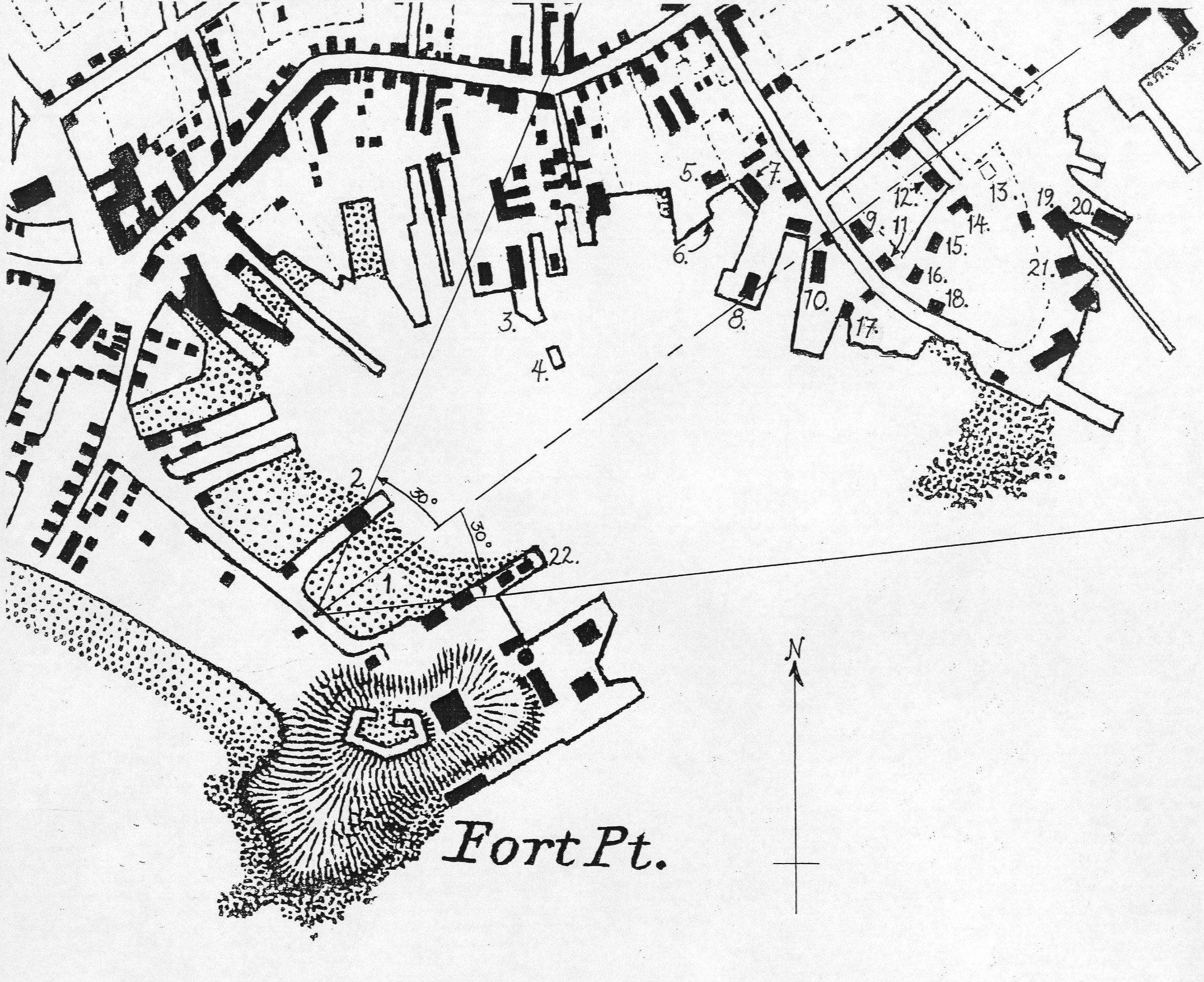
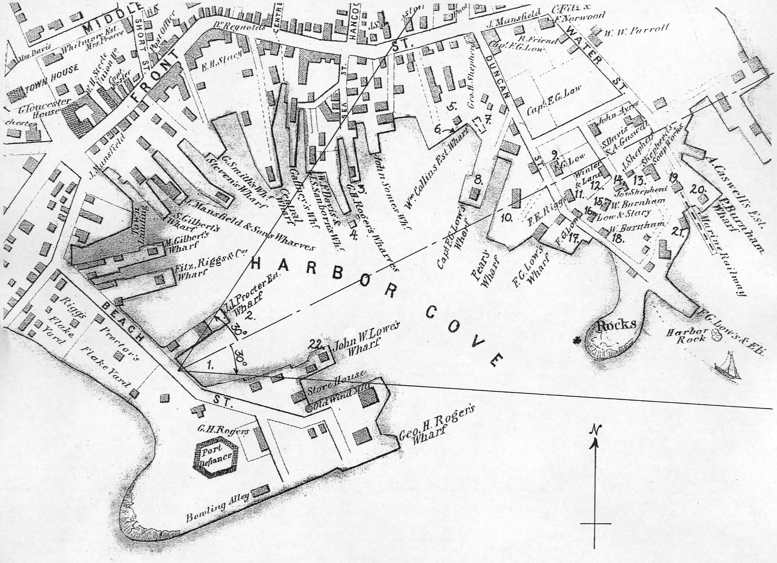
Viewpoint drawing showing Lane's location when making the drawing
Viewpoint drawing showing Lane's location when making the drawing
Provenance (Information known to date; research ongoing.)
the Artist, Gloucester, Mass.
Joseph L. Stevens, Jr., Gloucester, Mass.
Samuel H. Mansfield, Gloucester, Mass.
Cape Ann Museum, Gloucester, Mass., 1927
Marks & Labels
Marks: Inscribed upper left (in red ink): 68 [numbering system used by curator A. M. Brooks upon Samuel H. Mansfield's donation of the drawings to the Cape Ann Museum]
Exhibition History
No known exhibitions.Published References
Paintings and Drawings by Fitz Hugh Lane. Gloucester, MA: Cape Ann Historical Association, 1974., fig. 76.
Martha Oaks. "Gloucester At Mid-Century: The World of Fitz Hugh Lane, 1840–1865." Gloucester, Mass.: Cape Ann Historical Society. (exhibition catalogue)., ill., p. 16. ⇒ includes  text
text
Wilmerding, John. Fitz Henry Lane. Gloucester, MA: Cape Ann Historical Association, 2005. Reprint of Fitz Hugh Lane, by John Wilmerding. New York: Praeger, 1971. Includes new information regarding the artist's name., ill. 29.
Craig, James. Fitz H. Lane: An Artist's Voyage through Nineteenth-Century America. Charleston, SC: The History Press, 2006., fig. 70.
Dunlap, Sarah, and Stephanie Buck. Fitz Henry Lane: Family and Friends. Gloucester, MA: Church & Mason Publishing; in association with the Cape Ann Historical Museum, 2007., ill., cover.
Commentary
This drawing and View in Gloucester Harbor, 1850s (inv. 143) show mirror views of Gloucester's busy Inner Harbor. Lined with wharves, the sheltered cove (the Inner Harbor was also known as Harbor Cove) was valuable real estate for Gloucester's merchants. In this drawing, the view is from the shoreline of Fort Point looking towards Duncan's Neck. Duncan's Neck was a curved bit of land, much of which was owned by Frederick Low. Lane's stone house, on land he purchased in 1849, can be seen at the top of the hill with its three pointed gables.
The shoreline of Fort Point, from which the drawing was sketched, is near (or perhaps on) the Town Landing, and near one of George Rogers's wharves. The development of these wharves is well documented by Erik Ronnberg. Behind the viewer were the flake yards, and at the end projecting into the Harbor was the Fort. The drawing shows the wharves, with buildings lining them, and the graving beach (used for the cleaning of ships' hulls) once located along what is now Commercial Street. At high tide, vessels would be run aground on the beach. When the tide receded, leaving a boat grounded in the sand, repairs could be easily made to its hull and rigging.
Lane’s drawing of Harbor Cove from the graving beach on its southwest shore line, looking northeast, is unique among his depictions of this harbor – all the more so as no derivative painting (or published description thereof) has been found to date. It is also notable for including the artist’s new house at the drawing’s visual center with the wharves of I.J. Procter and John W. Lowe pointing insistently in its direction.
Few other works by Lane contain a view of his house. In Gloucester Harbor, 1856 (inv. 75) and its drawing, Gloucester from Fresh Water Cove, 1850s (inv. 144), the three gables of its south west side can be seen peeking over Fort Point, just to the left of the old Fort’s remains. The house can also be seen – with difficulty – in his 1859 lithograph of the Inner Harbor (View of Gloucester, 1859 (inv. 446); a hand-colored print, View of Gloucester, 1859 (inv. 91), shows the gabled roof more distinctly. This drawing provides the only view of the house that is nearly unobstructed (part of the first floor, below window level, is obscured by the house of Fitz E. Riggs.)
The location of Lane’s new residence and studio is significant in several ways. Harbor Cove was no longer a place to be visited and depicted on occasion; it was now his neighborhood, with several previous clients as his new neighbors, whom he would see on a daily basis. It also placed him in the heart of Gloucester, which would have made his involvement in civic activities and celebrations more accessible and conspicuous. (Ref. 1)
This drawing could have been made as early as 1850, assuming the exterior construction and roof work were complete. The building was occupied in 1851, first by Ignatius Winter and his family, and later in that year by Lane. (Ref. 2) The absence of one detail in the drawing argues against a date later than 1853, namely the absence of a smoke stack (then under construction) for the steam engine to operate the hauling winch and the mill saw at Burnham Brothers’ marine railway. Were it present, Lane certainly could not have ignored what was to be a significant landmark in his later depictions of this area. (Ref. 3)
While the house’s location gave it scenic prominence, it is likely that Lane valued it chiefly for the view of Gloucester Harbor and its skyline which he could study from the comfort and convenience of his studio at all hours and in any weather. It is after he moved there that his paintings show greater development of color, mood, subtlety, and drama in cloud formations, Similarly, his sunsets became more intense and serene. (Ref. 4) Working outdoors only in pencil forced him to paint such effects from memory in his studio which, if it had only limited visual access to the sky, would have been a hindrance. In his new studio, he could study and capture cloud formations and atmospheric colors, lending drama or serenity to a scene as he seldom had before.
–Erik Ronnberg
References:
1. Dunlap, Sarah and Stephanie Buck, Fitz Henry Lane: Family and Friends (Gloucester, MA: Church & Mason Publishing and Cape Ann Museum, 2007), pp. 53-57.
2. Ibid., p. 64.
3. Gloucester City Archives, Valuations for Harbor Parish, East Ward, 1851, 1852, 1853, 1854.
Valuations for wharf facilities and railway, 1851: $3,280; 1852: $4,800; 1853: $6,000; 1854: $9,000.
This steady and substantial growth is hard to explain in any other way than in the form of mechanical improvements, including steam-powered machinery to operate the hauling winch and power saws for a mill building for shipbuilding timber and planking. A note in the 1853 valuation, simply stating “new railway”, probably refers to the addition of a second railway, which would account for the significantly higher valuation in 1854.
4. On cloud formations: as in Gloucester Harbor, 1852 (inv. 38), Brig Off the Maine Coast, 1851 (inv. 241), Boston Harbor, 1854 (inv. 341), and Clipper Ship "Southern Cross" in Boston Harbor, 1851 (inv. 253). Sunsets: as in Norman's Woe, Gloucester Harbor, 1862 (inv. 1), View of Camden Mountains from Penobscot Bay, c.1852 (inv. 207), Lumber Schooners at Evening on Penobscot Bay, 1863 (inv. 343), and Becalmed Off Halfway Rock, 1860 (inv. 344).
Key to the Drawing
This key is based on two contemporaneous maps of Gloucester Harbor: (1) Henry Francis Walling, “Map of the towns of Gloucester and Rockport, Essex Co. Massachusetts” (Philadelphia: A. Kollner, 1851) and (2) A. D. Bache, Superintendent, “Preliminary Chart of Gloucester Harbor, Massachusetts” (Washington, DC: Survey of the Coast of the United States, 1854). There are differences between these two sources, the locations and sizes of buildings in the Walling map being closer to Lane’s depictions, while the Coast Survey chart appears to show the shoreline and wharf locations with greater accuracy. This is to be expected, given their very different uses. It was nevertheless possible to locate the wharves in both maps with little difficulty. Only the locations of some buildings were difficult to find in the Coast Survey chart, which probably includes some changes post-dating the Walling map, and a few seeming omissions.
Using the Walling map of Gloucester Harbor, wharves and buildings around Harbor Cove were identified and labeled, then matched to corresponding structures in the Coast Survey chart. With the right and left margins of the drawing determined, the angle of view and its center line were drawn and the angle of view measured as 60 degrees. This agrees closely with Lane’s practice in other drawings where the angles of view are usually multiples of 15 degrees, suggesting his use of a viewing aid, possibly divided into quadrants as promoted by the Danish artist Eckersberg and his followers.
Key to drawing showing buildings and wharves depicted.
Working clockwise from Beach Street on the causeway to Fort Point: