An online project under the direction of the CAPE ANN MUSEUM
Catalogue Entry
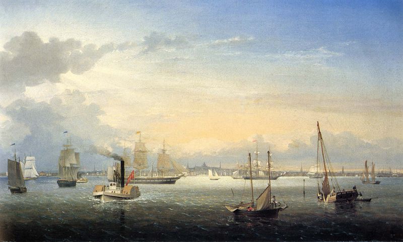
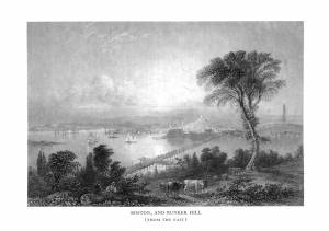
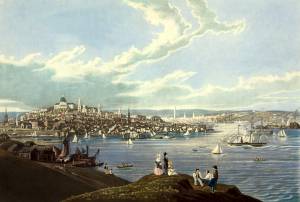
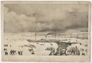
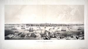
Looking west from Governor’s Island on a breezy afternoon, we see the Boston waterfront, from Charlestown and the naval shipyard at far right, to the South Boston Flats at far left. At center is the gilt dome of the Massachusetts State House, flanked by the steeples of Park Street Church and the Old South Meeting House to the left, and the newly built (1853) First Baptist Church to the right. This depiction of Boston by Lane appears to be his earliest to show the Baptist church, newly added to the skyline.
Gusty variable winds are blowing in the harbor. It has caused the sloop in the right foreground to heel alarmingly while the crew has hastily dropped her sails, part of the main sail having landed in the water. To the sloop’s left, a schooner-rigged boat lowers sail in similar haste as one of her crew goes forward to drop the anchor. Elsewhere, some vessels are contending with strong gusts, like the clipper ship and schooner seen through the schooner boat’s masts, while vessels in the painting’s left half are standing up to somewhat milder breezes and wind shifts. Such a situation can change quickly as a summer storm passes to the westward, bringing localized and erratic wind shifts.
While sailing vessels dominate this scene, there are three examples of side-wheel steamers in this painting, all in the coastal passenger service. In the left foreground, and immediately astern to the left, are two smaller examples for carrying commuters and short-haul goods to nearby towns along Boston’s north and south shores. At center background, directly below the State House, is a larger example used for longer routes along New England’s northern and southern coasts. While hardly dominant in this scene, they are a portent of changes to come.
This painting has added significance to Lane’s depictions of Boston Harbor, as it is very possible that it was the first to use his revised drawing of the Boston skyline as seen from Governor’s Island Boston Harbor, 1850s (inv. 158). This drawing—now composed of two attached sheets—once had a third sheet, as evidenced by a register mark on the right margin. Whether this missing sheet was also a revision—or part of an earlier drawing whose details Lane regarded adequate—is now an open question. The drawing includes much of Boston’s North End, which changed little in profile, as well as railroad termini, which changed considerably. Naval facilities in Charlestown were fairly static in this period. Lane’s subsequent paintings of Boston Harbor adhere closely to the viewing point and skyline details in this drawing.
– Erik Ronnberg
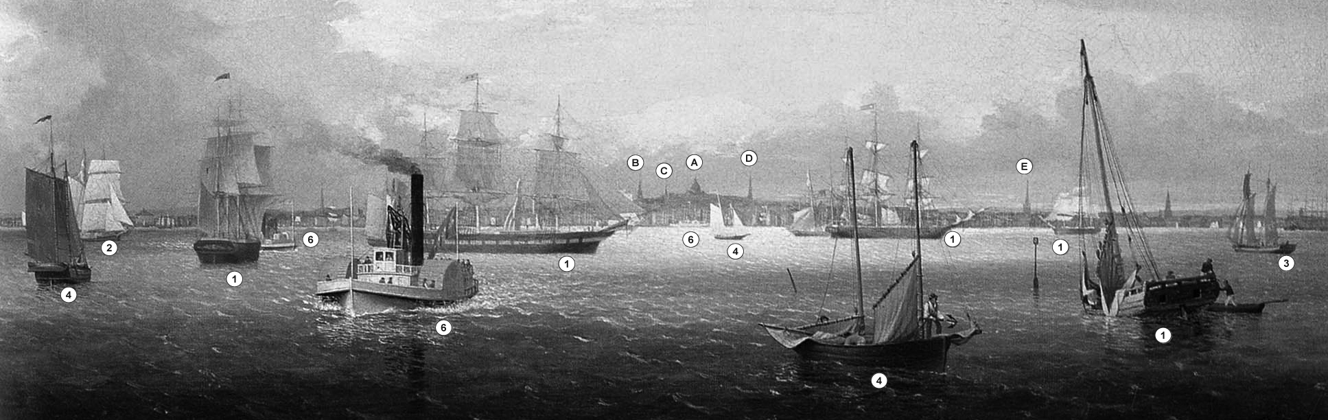
Key to buildings on Boston skyline:
A. Massachusetts State House
B. Park Street Church
C. Old South Meeting House
D. First Baptist Church
E. Christ Church – "Old North Church"
Key to vessel types:
1. Full-rigged ships
2. Half-brig (hermaphrodite brig)
3. Topsail schooner
4. Schooners
5. Sloop
6. Coastal steamship
- Subject Types
: - Seasons / Weather
: - Sunset »
- Vessel Types
: - Massachusetts Locales
: - Objects
: - Building Types
:
Historical Materials
1837 9 x 14 in. Cape Ann Museum Library & Archive
Showing Lane's neighborhood while working in Boston. Lane had studios at the intersection of Washington and State Streets, Summer, Tremont and School Streets.
Also filed under: Lane & Scott's, Lith. – Boston » // Maps » // Professional » // Residences » // Tremont Temple »
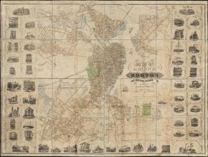
1847 Map insert to Boston Almanac and Directory Cape Ann Museum Library & Archive
Also filed under: Maps » // Residences » // Tremont Temple »
Printed map inside Boston Almanac
Published by B. B. Mussey & Co. and Thomas Groom, Boston
Cape Ann Museum Library & Archive (R910.45 B65 1848)
Map at front of almanac with Tremont Temple highlighted.
Also filed under: Boston Harbor » // Maps » // Tremont Temple »
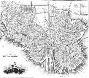
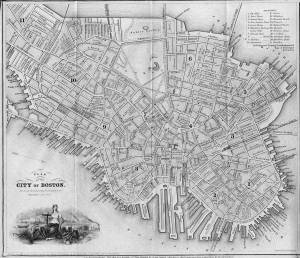
1852 Boston Boston Public Library: Norman B. Leventhal Map Center Call Number: G3764.B6 1852.M35
Also filed under: Maps » // Residences »
During the years after the war of 1812 and before the Civil War, the port of Boston was a center of American deep-water shipping. Trading with China, India, and the West Indies, which had fueled maritime growth in the early years of the century gave way to re-exporting these goods and foreign trade based on the shoe and textile trades. Although second to New York in terms of shipping tonnage, many of New York's shipbuilders and merchants were Boston based. In addition, ship building continued in Boston. Also, the coastal trade (the domestic trade up and down the coast) was still the most efficient way to transport goods and passengers, and accounts for much of the tonnage and shipping traffic.
Although dwarfed by New York, Boston was an active port in the 1840s and 1850s. Its registered tonnage rose from 149,186 in 1840 to 270,510 in 1850. The harbor was a crowded place. For example, on September 18, 1850, 32 ships, 49 barks, 47 brigs, and 52 schooners were reported at Boston.(1)
In 1849, foreign entries at Boston included 215 ships, 305 barks, 908 brigs, and 52 schooners. Coastwise arrivals included 193 ships, 488 barks, 1087 brigs, 4287 schooners, 89 sloops, and 65 schooners.(2)
(1) W.H. Bunting, p.8.
(2) Ibid.
For more information:
Samuel Eliot Morrison, The Maritime History of Massachusetts, 1783-1860
W.H. Bunting, Portrait of a Port, Boston 1852-1914 Cambridge: The Belknap Press of Harvard University, 1971.
Printed map inside Boston Almanac
Published by B. B. Mussey & Co. and Thomas Groom, Boston
Cape Ann Museum Library & Archive (R910.45 B65 1848)
Map at front of almanac with Tremont Temple highlighted.
Also filed under: Boston City Views » // Maps » // Tremont Temple »
Harvard Depository: Widener (NAV 578.57)
For digitized version, click here.
Also filed under: Signal Systems (Flags & Maritime Codes) »
Tinted lithograph with hand coloring
13 7/8 x 22 3/8 in.
Boston Athenaeum
From Sally Pierce and Catharina Slautterback, Boston Lithography, 1825–1880: The Boston Atheneaum Collection (Boston: Athenaeum, 1991): "Tidd drew this print when he was a consulting engineer for Simpson's. He has depicted the clipper ship 'Southern Cross' in the dry dock. Built in 1851, she was known for having sailed from San Francisco to Hong Kong in the record breaking time of thirty-two days. The Bethlehem Ship Building Company eventually took over this location and operated a dry dock there until the mid 1940s."
Also filed under: "Southern Cross" (Clipper Ship) » // M. M. Tidd, Lith. – Boston »
Library of Congress Catalog Number 2004671768
Also filed under: "Britannia" (Cunard Steamship) »
1853
Bostonian Society (1884.0209)
Also filed under: Scott, John W. A. »
1 print : lithograph, tinted ; image 50.3 x 111.9 cm., 68.7 x 121.2 cm.
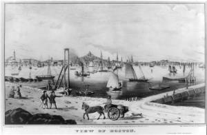
View of the city of Boston from East Boston showing Boston Harbor. The wharves of East Boston can be seen in the foreground.
Number nine of thirty-eight city views published in "Whitefield's Original Views of (North) American Cities (Scenery).
On stone by Charles W. Burton after a drawing by Edwin Whitefield.
Inscribed in brown ink lower right corner of sheet: "Boston Athenaeum from Josiah Quincy. September 28, 1848."
Local Notes:#1848.1.
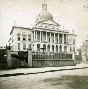
The "new" State House is located across from the Boston Common on the top of Beacon Hill, and serves as the Massachusetts state capital. The land was once owned by Massachusetts's first elected governor, John Hancock. Charles Bullfinch was the architect of the building, which was completed in 1798.
The dome was originally roofed with wood shingles, which leaked. In 1802 it was covered with copper by Paul Revere's Revere Copper Company. The dome was first painted gray and then light yellow before being gilded with gold leaf in 1874.
lithograph
1832
"Salmon pinxt" at lower left; "Pendleton, Boston" at lower right
Also filed under: Pendleton's, Lith. – Boston » // Salmon, Robert »
Lithograph
Published by N. Currier, New York
Library of Congress Catalog Number 2002698122
Also filed under: Currier (& Ives) – New York »
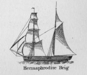
Hermaphrodite brigs—more commonly called half-brigs by American seamen and merchants—were square-rigged only on the fore mast, the main mast being rigged with a spanker and a gaff-topsail. Staysails were often set between the fore and main masts, there being no gaff-rigged sail on the fore mast. (1)
The half-brig was the most common brig type used in the coasting trade and appears often in Lane’s coastal and harbor scenes. The type was further identified by the cargo it carried, if it was conspicuously limited to a specialized trade. Lumber brigs (see Shipping in Down East Waters, 1854 (inv. 212) and View of Southwest Harbor, Maine: Entrance to Somes Sound, 1852 (inv. 260)) and hay brigs (see Lighthouse at Camden, Maine, 1851 (inv. 320)) were recognizable by their conspicuous deck loads. Whaling brigs were easily distinguished by their whaleboats carried on side davits (see ). (2)
– Erik Ronnberg
References:
1. M.H. Parry, et al., Aaak to Zumbra: A Dictionary of the World's Watercraft Newport News, VA: The Mariners’ Museum, 2000), 268, 274; and A Naval Encyclopaedia (L.R. Hamersly & Co., 1884. Reprint: Detroit, MI: Gale Research Company, 1971), 93, under "Brig-schooner."
2. W.H. Bunting, An Eye for the Coast (Gardiner, ME: Tilbury House: 1998), 52–54, 68–69; and W.H. Bunting, A Day's Work, part 1 (Gardiner, ME: Tilbury House: 1997), 52.

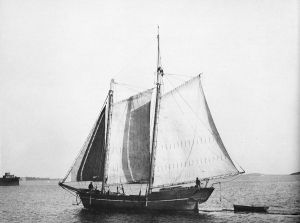
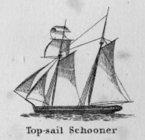
Schooners in Lane’s time were, with few exceptions, two-masted vessels carrying a fore-and-aft rig having one or two jibs, a fore staysail, gaff-rigged fore- and main sails, and often fore- and main topsails. One variant was the topsail schooner, which set a square topsail on the fore topmast. The hulls of both types were basically similar, their rigs having been chosen for sailing close to the wind. This was an advantage in the coastal trade, where entering confined ports required sailing into the wind and frequent tacking. The square topsail proved useful on longer coastwise voyages, the topsail providing a steadier motion in offshore swells, reducing wear and tear on canvas from the slatting of the fore-and-aft sails. (1)
Schooners of the types portrayed by Lane varied in size from 70 to 100 feet on deck. Their weight was never determined, and the term “tonnage” was a figure derived from a formula which assigned an approximation of hull volume for purposes of imposing duties (port taxes) on cargoes and other official levies. (2)
Crews of smaller schooners numbered three or four men. Larger schooners might carry four to six if a lengthy voyage was planned. The relative simplicity of the rig made sail handling much easier than on a square-rigged vessel. Schooner captains often owned shares in their vessels, but most schooners were majority-owned by land-based firms or by individuals who had the time and business connections to manage the tasks of acquiring and distributing the goods to be carried. (3)
Many schooners were informally “classified” by the nature of their work or the cargoes they carried, the terminology coined by their owners, agents, and crews—even sometimes by casual bystanders. In Lane’s lifetime, the following terms were commonly used for the schooner types he portrayed:
Coasting schooners: This is the most general term, applied to any merchant schooner carrying cargo from one coastal port to another along the United States coast (see Bar Island and Mt. Desert Mountains from Somes Settlement, 1850 (inv. 401), right foreground). (4)
Packet schooners: Like packet sloops, these vessels carried passengers and various higher-value goods to and from specific ports on regular schedules. They were generally better-maintained and finished than schooners carrying bulk cargoes (see The Old Fort and Ten Pound Island, Gloucester, 1850s (inv. 30), center; and Gloucester Inner Harbor, 1850 (inv. 240), stern view). (5)
Lumber schooners: Built for the most common specialized trade of Lane’s time, they were fitted with bow ports for loading lumber in their holds (see View of Southwest Harbor, Maine: Entrance to Somes Sound, 1852 (inv. 260)) and carried large deck loads as well (Stage Rocks and the Western Shore of Gloucester Outer Harbor, 1857 (inv. 8), right). Lumber schooners intended for long coastal trips were often rigged with square topsails on their fore masts (see Becalmed Off Halfway Rock, 1860 (inv. 344), left; ; and Lumber Schooner in a Gale, 1863 (inv. 552)). (6)
Schooners in other specialized trades. Some coasting schooners built for carrying varied cargoes would be used for, or converted to, special trades. This was true in the stone trade where stone schooners (like stone sloops) would be adapted for carrying stone from quarries to a coastal destination. A Lane depiction of a stone schooner is yet to be found. Marsh hay was a priority cargo for gundalows operating around salt marshes, and it is likely that some coasting schooners made a specialty of transporting this necessity for horses to urban ports which relied heavily on horses for transportation needs. Lane depicted at least two examples of hay schooners (see Gloucester Harbor, 1850s (inv. 391), left; and Coasting Schooner off Boon Island, c.1850 (inv. 564)), their decks neatly piled high with bales of hay, well secured with rope and tarpaulins.
– Erik Ronnberg
References:
1. Howard I. Chapelle, The History of American Sailing Ships (New York: W.W. Norton & Co., 1935), 258. While three-masted schooners were in use in Lane’s time, none have appeared in his surviving work; and Charles S. Morgan, “New England Coasting Schooners”, The American Neptune 23, no. 1 (DATE): 5–9, from an article which deals mostly with later and larger schooner types.
2. John Lyman, “Register Tonnage and its Measurement”, The American Neptune V, nos. 3–4 (DATE). American tonnage laws in force in Lane’s lifetime are discussed in no. 3, pp. 226–27 and no. 4, p. 322.
3. Ship Registers of the District of Gloucester, Massachusetts, 1789–1875 (Salem, MA: The Essex Institute, 1944). Vessels whose shipping or fishing voyages included visits to foreign ports were required to register with the Federal Customs agent at their home port. While the vessel’s trade or work was unrecorded, their owners and master were listed, in addition to registry dimensions and place where built. Records kept by the National Archives can be consulted for information on specific voyages and ports visited.
4. Howard I. Chapelle, The National Watercraft Collection (Washington, DC: Smithsonian Institution, 1960), 40, 42–43.
5. Ibid., 42–43, 73.
6. Ibid., 74–76.

In R. H. Dana, The Seaman's Friend, 13th ed. (Thomas Groom & Co. Publisher, 1873)
A topsail schooner has no tops at her foremast, and is fore-and-aft rigged at her mainmast. She differs from an hermaphrodite brig in that she is not properly square-rigged at her foremast, having no top, and carrying a fore-and-aft foresail instead of a square foresail and a spencer.

Detail views: marine railway and hauling cradle for vessel Wood rails, metal rollers, chain; wood cradle. Scale: ½" = 1' (1:24) Original diorama components made, 1892; replacements made, 1993. Cape Ann Museum, from Gloucester Chamber of Commerce, 1925 (2014.071)
A schooner is shown hauled out on a cradle which travels over racks of rollers on a wood and metal track.
Also filed under: Burnham Brothers Marine Railway » // Marine Railways »

c. 1900 Glass plate negative Collection of Erik Ronnberg
Also filed under: Lobstering »
"The Maine Register for the Year 1855, embracing State and County Officers, and an abstract of the law and resolves; together with a complete business directory of the state, and a variety of useful information."
Details about Maine's lumber trade in 1855, see pp. 250–52
Also filed under: Castine » // Lumber Industry »

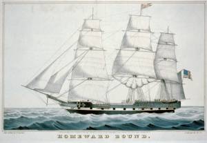
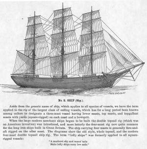
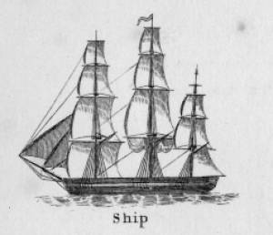
The term "ship," as used by nineteenth-century merchants and seamen, referred to a large three-masted sailing vessel which was square-rigged on all three masts. (1) In that same period, sailing warships of the largest classes were also called ships, or more formally, ships of the line, their size qualifying them to engage the enemy in a line of battle. (2) In the second half of the nineteenth century, as sailing vessels were replaced by engine-powered vessels, the term ship was applied to any large vessel, regardless of propulsion or use. (3)
Ships were often further defined by their specialized uses or modifications, clipper ships and packet ships being the most noted examples. Built for speed, clipper ships were employed in carrying high-value or perishable goods over long distances. (4) Lane painted formal portraits of clipper ships for their owners, as well as generic examples for his port paintings. (5)
Packet ships were designed for carrying capacity which required some sacrifice in speed while still being able to make scheduled passages within a reasonable time frame between regular destinations. In the packet trade with European ports, mail, passengers, and bulk cargos such as cotton, textiles, and farm produce made the eastward passages. Mail, passengers (usually in much larger numbers), and finished wares were the usual cargos for return trips. (6) Lane depicted these vessels in portraits for their owners, and in his port scenes of Boston and New York Harbors.
Ships in specific trades were often identified by their cargos: salt ships which brought salt to Gloucester for curing dried fish; tea clippers in the China Trade; coffee ships in the West Indies and South American trades, and cotton ships bringing cotton to mills in New England or to European ports. Some trades were identified by the special destination of a ship’s regular voyages; hence Gloucester vessels in the trade with Surinam were identified as Surinam ships (or barks, or brigs, depending on their rigs). In Lane’s Gloucester Harbor scenes, there are likely (though not identifiable) examples of Surinam ships, but only the ship "California" in his depiction of the Burnham marine railway in Gloucester (see Three Master on the Gloucester Railways, 1857 (inv. 29)) is so identified. (7)
– Erik Ronnberg
References:
1. R[ichard)] H[enry] Dana, Jr., The Seaman’s Friend, 13th ed. (Boston: Thomas Groom & Co., 1873), p. 121 and Plate IV with captions.
2. A Naval Encyclopaedia (Philadelphia: L. R. Hamersly & Co., 1884), 739, 741.
3. M.H. Parry, et al., Aak to Zumbra: A Dictionary of the World’s Watercraft (Newport News, VA: The Mariners’ Museum, 2000), 536.
4. Howard I. Chapelle, The History of American Sailing Ships (New York: W.W. Norton & Co., 1935), 281–87.
5. Ibid.
6. Howard I. Chapelle, The National Watercraft Collection (Washington, DC: Smithsonian Institution, 1960), 26–30.
7. Alfred Mansfield Brooks, Gloucester Recollected: A Familiar History (Gloucester, MA: Peter Smith, 1974), 67–69.
Photograph
From American Clipper Ships 1833–1858, by Octavius T. Howe and Frederick C. Matthews, vol. 1 (Salem, MA: Marine Research Society, 1926).
Photo caption reads: "'Golden State' 1363 tons, built at New York, in 1852. From a photograph showing her in dock at Quebec in 1884."
Also filed under: "Golden State" (Clipper Ship) »
_sm.jpg)

Oil on canvas
24 x 35 in.
Peabody Essex Museum, Salem, Mass.
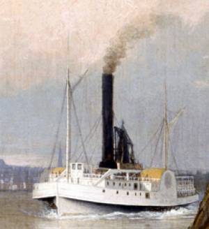
Walters' painting depicts the "Nonantum" homeward bound for Boston from Liverpool in 1842. The paddle-steamer is one of the four Clyde-built Britannia-class vessels, of which one is visible crossing in the opposite direction.
View related catalogue entries (2) »
Also filed under: Packet Shipping » // Walters, Samuel »
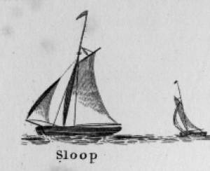
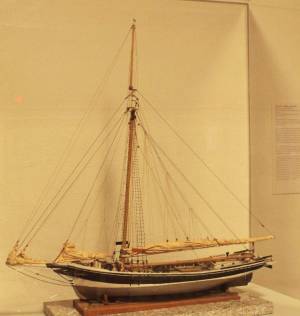
Sloops are one-masted sailing vessels which, in American examples, set fore-and-aft sails but usually no square sails. Thus, staysails, or jibs, are set from the fore stay(s) and a quadrilateral mainsail is set from the mast and spread by a gaff and a boom. The larger sloops would often set a triangular topsail over the main sail. (1)
The sloops depicted by Lane were used in various coastal trades, each with its own requirements, which dictated the sizes and details of their hulls and rigs. Most elegant were the packet sloops, which transported passengers, mail, and higher value goods between specific ports on regular schedules. They usually measured between sixty and seventy-five feet on deck, as dictated by anticipated shipping volume. Finely finished, they usually had stern galleries—a row of windows across the transom with ornamental moldings—and varied color schemes. Examples of packet sloops are in Gloucester Harbor from Rocky Neck, 1844 (inv. 14) (center, middle ground) and Study of Ships, 1851 (inv. 141) (foreground), both of which probably made trips between Gloucester and Boston, or Gloucester and Newburyport. (2)
Another specialized sloop of similar size was the stone sloop, used to ship granite blocks from stone-loading piers around Cape Ann to other ports. They were similar in rig to packet sloops, but of heavier construction with greater hold capacity and absence of decoration. Their stout appearance was augmented by simple color schemes, or even tarred topsides, reflecting the wear and strain imposed by their heavy cargos. Lane depicted these vessels in his painting of Fresh Water Cove from Dolliver's Neck, Gloucester, Early 1850s (inv. 45), with a sloop (at left) preparing to load at wharf-side, and another (at right) sailing out with a cargo. (3)
Sloops of the more work-a-day sort are the most commonly seen examples in Lane’s paintings, most of them appearing in his views of Boston Harbor. Usually deep-loaded and looking weather-worn, they contrast sharply with the packet- and clipper ships which dominate the scene. Sloops of this type are rarely seen in Lane’s paintings of Gloucester Harbor and the Maine coast, although they were certainly needed for short-distance transportation (see Bear Island, Northeast Harbor, 1855 (inv. 24), View of Camden Mountains from Penobscot Bay, c.1852 (inv. 207), Sunrise on the Maine Coast, Mount Desert Island, 1856 (inv. 295)). For coastal Maine, lack of railroads for heavier freight and greater distances between ports made the use of schooners with larger carrying capacity a greater necessity. (4)
In Lane’s views of New York Harbor, a regional sloop variant, the Hudson River Sloop, appears in New York Harbor, c.1855 (inv. 46) (bow view, left) and A Calm Sea, c.1860 (inv. 6) (stern view, right). This type had become prominent in the Hudson River packet trade between New York City, Albany, and beyond to points north and west as far as the eastern terminus of the Erie Canal. Large vessels for their rigs, they were well-finished and well-kept, reflecting pride of ownership and rivalry among their owners and crews. (5)
– Erik Ronnberg
References:
1. A Naval Encyclopaedia (Philadelphia: L.R. Hamersly & Co., 1884. Reprint: Detroit, MI: Gale Research Company, 1971), 59. See first definition of "sloop" and definition of "sloop-rigged."
2. Robert Greenhalgh Albion, William A. Baker, and Benjamin Woods Labaree, New England and the Sea (Mystic, CT: Mystic Seaport Museum, 1972; reprinted in 1994), 127–28.
3. Howard I. Chapelle, The History of American Sailing Ships (New York: W.W. Norton & Co., 1935), 300–02.
4. Ibid., 300.
5. Ibid., 298–300.
A Naval Encyclopaedia:
Dictionary of nautical words and phrases
Special Articles on Naval Art and Science
Philadelphia: L.R. Hamersly & Co.
'Mudian, "Mugian, or Bermudian. A boat special to the Bermuda islands, usually decked, with the exception of a hatch; from 2 to 20 tons burden; it is short, of good beam, and great draft of water abaft, the stem and keel forming a curved line. It carries an immense quantity of ballast. Besides a long main- and short jib-boom, it has a long, taperking, raking mast, stepped just over the forefoot, generally unsupported by shrouds or stays; on it a jib-headed mainsail is hoisted to a height of twice, and sometimes three times, the length of the keel. This sail is triangular, stretched at its foot by a long boom. The only other sail is a small foresail or jib. They claim to be the fastest craft in the world for working to windward in smooth water, it being recorded of one that she made five miles dead to windward in the hour during a race; and though they may be laid over until they fill with water, they will not capsize.
St. George's Historical Society
Detail of painting of St. George's Harbour, Bermuda, during US Civil War, with a Confederate blockade runner anchored in the foreground.
Also filed under: Puerto Rico »
Wood, metal, cordage, cloth, paint.
Scale: ¼ in. = 1ft. (1:48)
Cape Ann Museum. Gift of Roland and Martta Blanchet (1997.17.3)
Although built in 1890 and larger than the stone sloops of Lane’s time, the "Albert Baldwin’s" hull form, rig, and loading boom are very similar to those of the 1840s and 1850s.
Also filed under: Granite Quarrying / Shipping » // Ship Models »
"Engine-powered vessel" is a collective term used by nautical historians to include all vessel types using engine power of any type for propulsion, whether assisted by sails, oars, or other motive power. In Lane's time, steam reciprocating engines fueled by wood or coal were the only practical source of this power for ships using paddle-wheels or screw propellers to convert heat energy into motion.
For most of the nineteenth century, steamships had sails for auxiliary power; indeed the earliest examples relied principally on sails, using engine power in calm weather to shorten the voyage time or keep to a schedule. As engines became more efficient, powerful, and reliable, sail plans were reduced, to be used only to steady a vessel's motion in a seaway (for the sake of seasick passengers), or to maintain headway if the engine broke down. Only harbor craft, ferry boats, and coastwise passenger steamers relied solely on engine power.
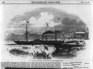
Among Lane's depictions of steamships, the auxiliary steam packet Auxiliary Steam Packet Ship Massachusetts, n.d. (inv. 442) is a good example of primary reliance on sails, while the steam demi-bark The "Britannia" Entering Boston Harbor, 1848 (inv. 49) and the Cunard Liner "Britannia", 1842 (inv. 259) have relegated sails to secondary (or simply emergency) motive power.
– Erik Ronnberg
Stereograph card Castine Historical Society Collections (2015.03)
Also filed under: Historic Photographs » // Steamers »
Published by James French, Boston
Volume 1848-49
Boston Public Library
Call number 39999059856813
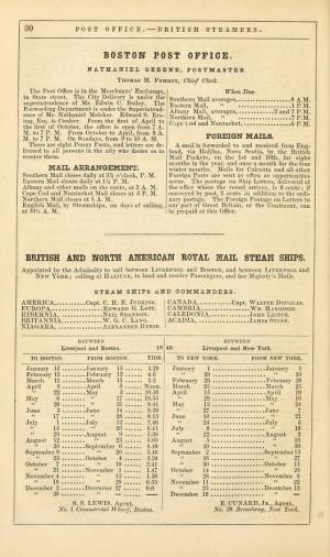
See p. 30 of directory.
Also filed under: "Britannia" (Cunard Steamship) » // "Caledonia" (Cunard Steamship) » // Trade Routes and Statistics »
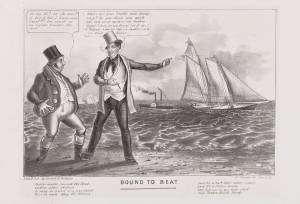
Cartoon
9 1/4 x 13 3/4 in (23.495 x 34.925 cm)
Peabody Essex Museum, Salem, Mass.
Jonny and a Yankee:
Jonny: "Ho my Hi! 'ow she goes!! it his'nt fair I ham sure t'aint!!! She must 'av an engine hunder the keel..."
Yankee: "Where are your yachts now, Jonny? s-a-y- Do you think your wash tubs can come up to a real Yankee Clipper? Sorry for you, Jonny, but it can't be helped... A Yankee Ship a Yankee Crew, you know Jonny."
Also filed under: "America" (Schooner Yacht) »
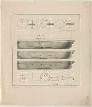
Lithograph
Library of Congress Catalog Number 2002706878
Design of side wheel steamer showing wheel mechanism, side view and cross-section in ten figures. This design proved a failure in the few vessels that employed it. The paddle wheel enclosures filled with water, causing resistance which greatly impaired efficiency and increased fuel consumption.
– Erik Ronnberg
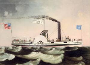
Oil on canvas
Maine Maritime Museum
Also filed under: Castine »
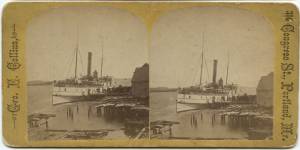
Steamer schedules for 1855, including the schedule for the steamer, "T. F. Secor" which served Castine, see pp. 234–35.
Also filed under: "T. F. Secor" (Steamboat) » // Castine » // Publications » // Steamers »
The yawl boat was a ninteenth-century development of earlier ships' boats built for naval and merchant use. Usually twenty feet long or less, they had round bottoms and square sterns; many had raking stem profiles. Yawl boats built for fishing tended to have greater beam than those built for vessels in the coastal trades. In the hand-line fisheries, where the crew fished from the schooner's rails, a single yawl boat was hung from the stern davits as a life boat or for use in port. Their possible use as lifeboats required greater breadth to provide room for the whole crew. In port, they carried crew, provisions, and gear between schooner and shore. (1)
Lane's most dramatic depictions of fishing schooners' yawl-boats are found in his paintings Gloucester Outer Harbor, from the Cut, 1850s (inv. 109) and /entry:311. Their hull forms follow closely that of Chapelle's lines drawing. (2) Similar examples appear in the foregrounds of Gloucester Harbor, 1852 (inv. 38), Ships in Ice off Ten Pound Island, Gloucester, 1850s (inv. 44), and The Fort and Ten Pound Island, Gloucester, Massachusetts, 1847 (inv. 271). A slightly smaller example is having its bottom seams payed with pitch in the foreground of Gloucester Harbor, 1847 (inv. 23). In Gloucester Inner Harbor, 1850 (inv. 240), a grounded yawl boat gives an excellent view of its seating arrangement, while fishing schooners in the left background have yawl boats hung from their stern davits, or floating astern.
One remarkable drawing, Untitled, n.d. (inv. 219) illustrates both the hull geometry of a yawl boat and Lane's uncanny accuracy in depicting hull form in perspective. No hull construction other than plank seams is shown, leaving pure hull form to be explored, leading in turn to unanswered questions concerning Lane's training to achieve such understanding of naval architecture.
– Erik Ronnberg
References:
1. Howard I. Chapelle, American Small Sailing Craft (New York: W.W. Norton & Co., 1951), 222–23.
2. Ibid., 223.
Oil on canvas
12 1/8 x 19 3/4 in.
Museum of Fine Arts, Boston, Bequest of Martha C. Karolik for the M.and M. Karolik Collection of American Paintings, 1815-1865 (48.447)
A schooner's yawl lies marooned in the ice-bound harbor in this detail.

The ensign of the United States refers to the flag of the United States when used as a maritime flag to indentify nationality. As required on entering port, a vessel would fly her own ensign at the stern, but a conventional token of respect to the host country would be to fly the flag of the host country (the United States in Boston Harbor, for example) at the foremast. See The "Britannia" Entering Boston Harbor, 1848 (inv. 49) for an example of a ship doing this. The American ensign often had the stars in the canton arranged in a circle with one large star in the center; an alternative on merchant ensigns was star-shaped constellation. In times of distress a ship would fly the ensign upside down, as can be seen in Wreck of the Roma, 1846 (inv. 250).
The use of flags on vessels is different from the use of flags on land. The importance and history of the flagpole in Fresh Water Cove in Gloucester is still being studied.
The modern meaning of the flag was forged in December 1860, when Major Robert Anderson moved the U.S. garrison from Fort Moultrie to Fort Sumter in Charleston Harbor. Adam Goodheart argues this was the opening move of the American Civil War, and the flag was used throughout northern states to symbolize American nationalism and rejection of secessionism.
Before that day, the flag had served mostly as a military ensign or a convenient marking of American territory, flown from forts, embassies, and ships, and displayed on special occasions like American Independence day. But in the weeks after Major Anderson's surprising stand, it became something different. Suddenly the Stars and Stripes flew—as it does today, and especially as it did after the September 11 attacks in 2001—from houses, from storefronts, from churches; above the village greens and college quads. For the first time American flags were mass-produced rather than individually stitched and even so, manufacturers could not keep up with demand. As the long winter of 1861 turned into spring, that old flag meant something new. The abstraction of the Union cause was transfigured into a physical thing: strips of cloth that millions of people would fight for, and many thousands die for.
– Adam Goodheart, Prologue of 1861: The Civil War Awakening (2011).
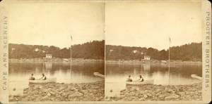
1860s Stereograph card Cape Ann Museum Library & Archive
A view of a Cove on the western side of Gloucester Harbor, with the landing at Brookbank. Houses are seen in the woods back. A boat with two men is in the foreground.
Also filed under: Brookbank » // Fresh Water Cove » // Historic Photographs »
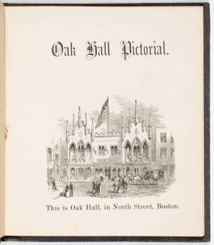
Courtesy American Antiquarian Society, Worcester, Mass. (CL.F9116.011.1854 CL.F9116.011.1854)
Also filed under: Oak Hall »
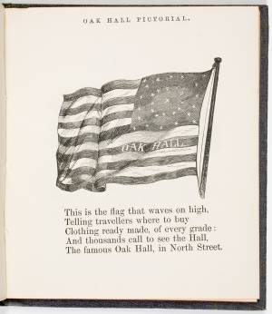
Courtesy American Antiquarian Society, Worcester, Mass. (CL.F9116.011.1854)
Also filed under: Oak Hall »
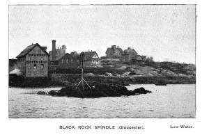
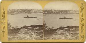
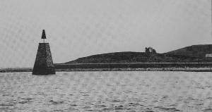
A "spindle" is a fixed marker to indicate a hazard to navigation (such as a rock which couldn't be seen at high tide). It serves the same purpose as a channel buoy, a "light beacon," or a “monument,” to warn vessels away from dangerous places or stretches of coastline. Spindles are usually iron rods with some sort of geometric object (round, flat, or triangular) on top, brightly painted (usually red) for visibility. Monuments, like the ones you see in Lane’s depictions of Half Way Rock or Norman’s Woe Reef, were made of stone and look like stumpy obelisks—or grave monuments. They were also essential as reference points for the early coastal surveys in their efforts to make more accurate charts.
In Castine, the notable square monument in the center of the harbor marked Hosmer's Ledge.

Photograph in The Illustrated Coast Pilot with Sailing Directions. The Coast of New England from New York to Eastport, Maine including Bays and Harbors, published by N. L. Stebbins, Boston
Also filed under: Gloucester Harbor, Inner / Harbor Cove »

Pencil and ink on paper
15 x 22 1/8 in.
Cape Ann Museum, Gloucester, Mass., Gift of Mr. Donald K. Usher, in memory of Mrs. Margaret Campbell Usher, 1984 (2401.19)
Also filed under: Gloucester Harbor, Outer » // Mackerel Fishing »
Stereograph card Castine Historical Society Collections (1996.1)
View related catalogue entries (2) »
Also filed under: Castine » // Historic Photographs »
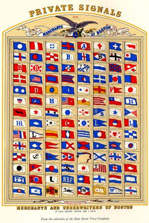
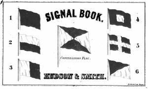
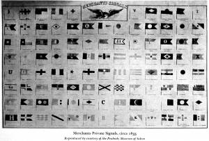
The use of signal flags, for ship-to-ship communication, generally preceded land-based chains of maritime semaphore stations, the latter using flags or rotating arms, until the advent of the electric or magnetic telegraph.
Until the end of the Napoleonic wars, merchant ships generally sailed in convoy as ordered by the escorting warship(s) using a few simple flags. Peace brought independent voyaging, the end of the convoy system, and the realization by various authorities that merchant vessels now needed their own separate means of signaling to each other. This resulted in a handful of rival codes, each with its individual flags and syntax. In general, they each had a section enabling ship identification and also a "vocabulary" section for transmitting selected messages. It was not until 1857 that a common Commercial Code became available for international use, only gradually replacing the earlier ones. All existed side by side for a decade or two.
Signal systems for American ships were originally intended to identify a vessel by name and owner; only later were more advanced systems developed to convey messages. Most basic were private signals, or "house flags", each of a different design or pattern, identifying the vessel's owner; identification charts were local and poorly distributed, limiting their usefulness. A secondary signal, a flag or large pennant bearing the vessel's name, was sometimes flown by larger ships, but pictorial records of them are uncommon. These private signal flags usually flew from the foremasthead or main masthead if a three master ship. Pilot boats had their own identifying flags, blue and white as seen in Spitfire Entering Boston Harbor, n.d. (inv. 536). Small vessels, such as schooners, often had a "tell-tale" pennant, an often-unmarked and often red flag, that was used to determine wind direction.
A numerical code flag system, identifying vessels by the code numbers, was introduced by Captain Frederick Marryat R.N. in 1817 for English vessels. American vessels soon adopted this system. Elford's "marine telegraphic system" was the first American equivalent to the Marryat code flags, first issued in 1823, and with changes, remaining in use until the late 1850s. Most of the signal flags on vessels depicted by Lane use Elford's; Brig "Antelope" in Boston Harbor, 1863 (inv. 43) is a noteworthy example of his depiction of Marryat's. The Elford's Code was popular in America on account of its simplicity and only required six blue and white flags. Eventually these changed to red and white, although it is unclear exactly when this happened. Instructions and a key ot the Elford's Code's use are included in successive editions of the Boston Harbor Signal Book.
Whereas the other codes employ at least ten flags of diverse shapes and colours, there are only six Elford flags in total, representing the numbers one to six. All are uniformly rectangular and monochrome in colour (either blue and white or red and white—or even black and white as in an early photograph). Selected from these six flags each individual vessel is allotted a combination of four flags to be prominently displayed as a vertical hoist. Reading from above down these convey its "designated number." Armed with this number and the type of vessel (e.g. ship, bark, brig, schooner /or steamer) the subject can be uniquely identified by reference to a copy of the Boston Harbor Signal Book for the appropriate year.
– A. Sam Davidson
As reproduced in Yankee Sailing Ship Cards by Allan Forbes and Ralph M. Eastman (Boston: State Street Trust Company, 1948).
Also filed under: "Eastern Star" (Bark) » // Forbes, Robert Bennet »
Harvard Depository: Widener (NAV 578.57)
For digitized version, click here.
Also filed under: Boston Harbor »
Boston: Eastburn's Press
New York Public Library
Complete book is included in Google Books, click here.
In The American Neptune 3, no. 3 (July 1943): 205–21.
Peabody Essex Museum
Descriptions of Marryat, Elford, Rogers, and commercial code signal systems, and private signals. Includes illustrations of flag systems with color keys.