An online project under the direction of the CAPE ANN MUSEUM
Catalogue Entry
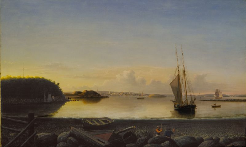
One of many views Fitz Henry Lane painted of the waterfront of his hometown, Gloucester Harbor demonstrates the artist’s mature style in its quiet repose and dominant luminous sky. Lane painted this view from Brookbank (the summer residence of Samuel E. Sawyer, one of his most important patrons), located on the Cape Ann shore south of Gloucester. The prosperous town appears at a serene distance across the smooth waters of the outer harbor, framed by the Old Fort on the left and the low hump of Ten Pound Island near the middle of the canvas. The almost still water reflects the clear light of the twilight sky, while shadows dim the curving shore to the left and the foreground of pebbly shore, which is strewn with boulders and the remains of discarded boats, a barrel, and a fish trap. Two men conversing on the beach and a fisherman in a small boat in the middle distance animate the quiet scene.
Gloucester Harbor, with its flat expanse of calm water, low horizon, glowing sky, and darker framing elements of land or tall ships, is typical of Lane’s shore scenes. In such later works, painted beginning in the mid-1850s, the accurate representation of individual vessels is subordinated to the unity of the entire composition, achieved partly through the emphasis on pervasive light and the contrasting relative darkness of solid foreground objects. In Gloucester Harbor, the transient effect of declining daylight and its potential for emotional expressiveness become as much Lane’s subject as the harbor itself. This approach, applied to coastal themes, is typical of the trend in landscape painting at the time and is dubbed “luminism” by modern scholars.
Lane painted numerous views of Gloucester Harbor from a variety of viewpoints, many showing the activity of men and vessels concerned with trade and fishing, the industries upon which the town had flourished since its establishment in the early seventeenth century. Even his busiest images, however, present Gloucester as a quiet, unhurried place by focusing on the harbor and by showing the town itself only from a distance, across placid waters, as it is here in the Terra Foundation’s painting. In fact, Gloucester was changing rapidly in the years Lane painted it intensively. The extension of the eastern railroad to the town in 1847 not only opened the local fisheries to larger markets but brought tourism to Gloucester and the nearby picturesque shoreline of Cape Ann. Lane profited by these changes, for he found patrons such as Sawyer among the town’s new summer residents. His paintings make no reference to such developments but preserve the Gloucester of his youth: a quiet fishing village.
– Terra Museum of American Art
- Subject Types
: - Landscape Types
: - Vessel Types
: - Vessel Activites
: - Beached »
- Cape Ann Locales
: - Objects
:
Historical Materials
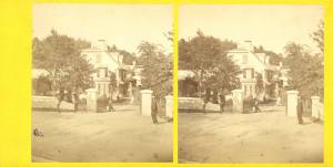
Brookbank was an early eighteenth-century white gambrel-roofed house on Fresh Water Cove which was owned and occupied by Samuel Sawyer and his ancestors. It is possible to trace apparent renovations to the house through Lane's pictures; at first it is depicted as a white house without dormers and a simple brown barn Fresh Water Cove, Gloucester, c.1864 (inv. 112); then dormers appear on the house and the barn is white with a cupola Fresh Water Cove, etc., from Dolliver's Neck, 1850s (inv. 113). In Gloucester from Brookbank, 1848 (inv. 42) a cobb wharf (log cabin-like structure) and boardwalk are visible. By Fresh Water Cove from Dolliver's Neck, Gloucester, Early 1850s (inv. 45) the house seems to have additions.
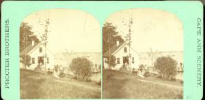
Stereograph card Cape Ann Museum Library & Archive
Stereo view of Brookbank guest house or boathouse.
Also filed under: Historic Photographs »
Published by Frank Rowell Cape Ann Museum Library & Archive
Stereograph card
Also filed under: Historic Photographs »
n.d. Stereographic card Cape Ann Museum Library & Archive
Penciled on reverse: "Mansion House, Brook Bank [sic], Sam'l Sawyer now Hammond, Freshwater Cove"
Also filed under: Historic Photographs » // Sawyer, Samuel »

44 x 34 in.
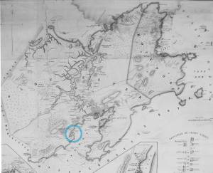
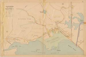
Henry Francis Walling, Map of the Towns of Gloucester and Rockport, Essex Co. Massachusetts. Philadelphia, A. Kollner, 1851
Cape Ann Museum Library & Archive
"Map of the Towns of Gloucester and Rockport, Massachusetts. H.F. Walling, Civil Engineer. John Hanson, Publisher. 1851. Population of Gloucester in 1850: 7,805. Population of Rockport in 1850: 3,213."
Also filed under: Annisquam River » // Dolliver's Neck » // Fresh Water Cove » // Gloucester Harbor, Outer » // Maps » // Norman's Woe » // Stage Rocks / Stage Fort / Stage Head » // Steepbank » // West Gloucester – Little River » // Western Shore »
Samuel Sawyer Papers
Cape Ann Museum Library & Archives
Archive Collection
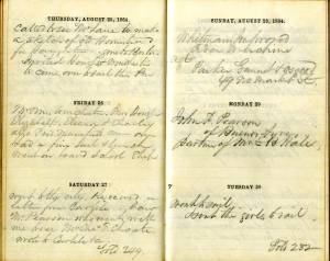
"August 25. Called to see Mr. Lane to make a sketch of old Homestead for Haughtons."
Also filed under: Diaries / Ledgers / Etc. » // Haughton, James » // Sawyer, Samuel »
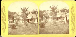
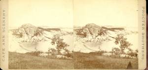
1860s Stereograph card Cape Ann Museum Library & Archive
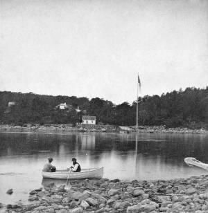
A view of a Cove on the western side of Gloucester Harbor, with the landing at Brookbank. Houses are seen in the woods back. A boat with two men is in the foreground.
Also filed under: American ensign / flag » // Fresh Water Cove » // Historic Photographs »
Stereograph card
Cape Ann Museum Library & Archive
Also filed under: Fresh Water Cove »
The owner of this flagpole has not been determined, but it is an interesting landmark in Lane's paintings. Often it appears in his drawings and not in his paintings, and Western Shore of Gloucester Outer Harbor, 1857 (inv. 107) contains the only image of a flag actually flying from the pole.
Fresh Water Cove is located on the west side of Gloucester’s Outer Harbor. It is protected from the harbor waters and the south-easterly seas by the arm of Dolliver’s Neck reaching north from the western shore. It’s a small, very still cove, only a few hundred yards from its mouth to the innermost shore.
The cove was visited by Samuel de Champlain in 1606. He was the first known European to enter Gloucester Harbor, which he named Le Beauport. He named Fresh Water Cove for the fresh water springs he found there, one a bit up from the shore, the other flowing below the high tide line and only accessible at half tide.
The cove, while very well protected from the weather, is small and very shallow at low tide and was never suitable for any large vessels, though there were fishing shacks along the shores edge and small boats were easily pulled up on the sand and salt marsh in its inner recesses. There was a wharf built in the early 1800s to service a granite quarry just up the hill from the cove, which could apparently handle larger vessels at high tide.
In Lane’s time, the most significant landmark from the cove was Brookbank, the Sawyer homestead where Samuel E. Sawyer was born in 1818. Sawyer made a fortune in Boston and returned to Brookbank every summer for fifty years. He became one of Gloucester’s first philanthropists. Lane did a series of paintings from the fields in front of Brookbank looking to the east from the house over Fresh Water Cove, the arm of Dolliver’s Neck and the harbor beyond. He also painted the opposite view in Fresh Water Cove from Dolliver's Neck, Gloucester, Early 1850s (inv. 45) looking west from Dolliver’s Neck over the cove to the Sawyer homestead and surrounding shoreline. Each of these paintings captures the perfect serenity of a high summer day in this secluded cove just off the busy harbor.
Stereograph card
Cape Ann Museum Library & Archive
Also filed under: Brookbank »
44 x 34 in.
Henry Francis Walling, Map of the Towns of Gloucester and Rockport, Essex Co. Massachusetts. Philadelphia, A. Kollner, 1851
Cape Ann Museum Library & Archive
"Map of the Towns of Gloucester and Rockport, Massachusetts. H.F. Walling, Civil Engineer. John Hanson, Publisher. 1851. Population of Gloucester in 1850: 7,805. Population of Rockport in 1850: 3,213."
Also filed under: Annisquam River » // Brookbank » // Dolliver's Neck » // Gloucester Harbor, Outer » // Maps » // Norman's Woe » // Stage Rocks / Stage Fort / Stage Head » // Steepbank » // West Gloucester – Little River » // Western Shore »
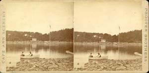
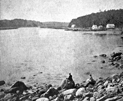
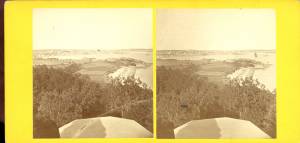
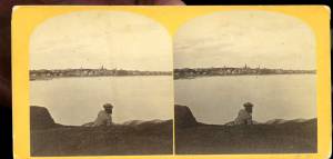
c.1860 Stereograph card Cape Ann Museum Library & Archive
Taken from Steepbank, on the western side of Gloucester Harbor, and showing a small boat at anchor in the cove, then the Neck, and the sea beyond.
Also filed under: Dolliver's Neck » // Historic Photographs » // Lone Pine » // Steepbank »
Newspaper
"Mr. Lane has just completed a third picture of the Western Shore of Gloucester Harbor, including the distance from 'Norman's Woe Rock' to 'Half Moon Beach.' It was painted for Mr. William E. Coffin of Boston, and will be on exhibition at the artist's rooms for only a few days; we advise all our readers who admire works of art, and would see one of the best pictures Mr. Lane has ever executed..."
"...solitary pine, so many years a familiar object and landmark to the fisherman."

Newsprint
From bound volume owned by publisher Francis Procter
Collection of Fred and Stephanie Buck
"We visited the studio of Mr. Fitz H. Lane a few days since, and were much pleased in examining some fine paintings from the pencil of this talented artist. Among the collection was a view of Long Beach, in this town, with which we were particularly interested.
The scene is taken immediately after a storm. The waves with their snowy crests are rolling in upon the beach, breaking against the sides of a vessel which has been driven ashore. In the background is seen the residence of Mr. Fessenden, and the surrounding scenery; on the right are visible the high headlands near the residence of Mr. Geo. Hovey, while stretching far away in the distance may be seen Fresh Water Cove, Dolliver's Neck, and the Old Pine Tree, the whole forming a beautiful picture and true to Nature.
Several other paintings were in process of completion, one a beautiful sunset scene, which was really beautiful to gaze upon; also a view of a gale at sea, with a gallant ship plunging madly through the waves, forming a striking contrast to the mild placid scene of the picture at its side.
Mr. Lane's paintings are true to nature, and in viewing them one can but admire the skill and genius of this talented artist, We advise all lovers of the art, who wish to spend an hour pleasantly, to visit the studio of Mr. Lane on Locust St. We can assure them that they will come away highly gratified, and have an earnest desire to call again." (1)
(1) See p. 2, column 3, Courtesy of the American Antiquarian Society
Also filed under: Chronology » // Dolliver's Neck » // Fessenden, C. B. » // Lone Pine » // Newspaper / Journal Articles » // Steepbank » // Studio Descriptions »
1860s Stereograph card Cape Ann Museum Library & Archive
A view of a Cove on the western side of Gloucester Harbor, with the landing at Brookbank. Houses are seen in the woods back. A boat with two men is in the foreground.
Also filed under: American ensign / flag » // Brookbank » // Historic Photographs »
4 x 5 in.
Cape Ann Museum Library & Archive
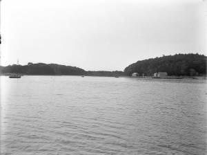
Freshwater Cove and Dolliver's Neck from the water off Stage Fort.
Also filed under: Dolliver's Neck »
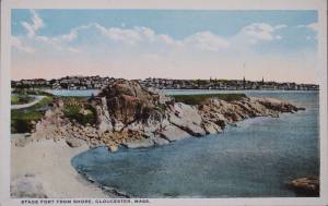
The Stage, as it was known in Lane’s time, now Stage Fort Park, rises from the western shore of the Outer Harbor, just south and west of the Cut and the Blynman Bridge as you leave Gloucester. This was the first settlement of the Massachusetts Bay Colony in 1623 where fourteen men of the Dorchester Company landed and tried in vain to settle and survive through a combination of fishing and farming. They were successful at neither, and in 1626 they moved on and founded Salem.
During the Revolution the Gloucester patriots built a fort on the north side of Half Moon Beach to defend against British invaders which was never needed. The fort was restored for the War of 1812 and again for the Civil War, but again saw no action.
During Lane’s lifetime this area was the Hough farm. Townspeople were generally given free run of the place for strolling and picnics overlooking the harbor. The enormous rounded boulders and ledge outcroppings rose dramatically from the fields above the harbor without the tree cover that partially obscures them today.
Lane did numerous paintings of this area, including many views looking westward from the vantage point onboard a boat in the harbor. In Stage Rocks and the Western Shore of Gloucester Outer Harbor, 1857 (inv. 8) the Stage Rocks frame the west side of Gloucester Harbor and provided a peaceful and bucolic counterpoint to the intense activity of the city waterfront only a mile away across the harbor. Lane also painted the Stage Rocks from the beach just to the north near the Cut and Field Beach, which is on the southern side of the Stage Rocks facing out the harbor entrance to the sea.
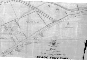
Commonwealth of Massachusetts: Southern Essex District Registry of Deeds
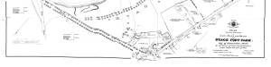
1543 plan 0141_0002
The third of the three plans has the references on it. "Plan showing the taking of land, flats and beach for Stage Fort Park…1898..."
Includes a reference to the home of Mary Turnbull which is Steepbank.
Also filed under: Maps » // Steepbank »
c.1870 Stereograph card Cape Ann Museum Library & Archive
Also filed under: Gloucester – City Views » // Half Moon Beach » // Historic Photographs » // Steepbank »
44 x 34 in.
Henry Francis Walling, Map of the Towns of Gloucester and Rockport, Essex Co. Massachusetts. Philadelphia, A. Kollner, 1851
Cape Ann Museum Library & Archive
"Map of the Towns of Gloucester and Rockport, Massachusetts. H.F. Walling, Civil Engineer. John Hanson, Publisher. 1851. Population of Gloucester in 1850: 7,805. Population of Rockport in 1850: 3,213."
Also filed under: Annisquam River » // Brookbank » // Dolliver's Neck » // Fresh Water Cove » // Gloucester Harbor, Outer » // Maps » // Norman's Woe » // Steepbank » // West Gloucester – Little River » // Western Shore »
c.1870 Stereograph card Cape Ann Museum Library & Archive
Also filed under: Half Moon Beach » // Historic Photographs » // Western Shore »
c.1870 Stereograph card Cape Ann Museum Library & Archive
Also filed under: Gloucester – City Views » // Historic Photographs »
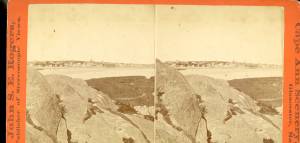
c.1890 Stereograph card Cape Ann Museum Library & Archive
"In the foreground is a clear sheet of water which washes upon the beach beyond. The Pavilion is quite prominent, while upon the rising background can be seen the steeples of the several churchs, the tower of the first Town House, and the Collins School House."
Also filed under: Gloucester – City Views » // Historic Photographs » // Pavilion Hotel »
Cape Ann Museum Library & Archive
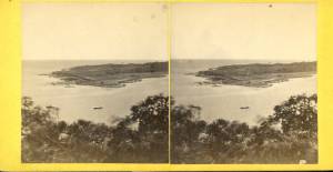
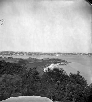
Stage Fort from Hough's Farm, showing a panorama of the harbor from Pavilion Beach to Fort Point and Rocky Neck.
Also filed under: Field Beach / Crescent (or Cressy's) Beach / Long Beach »

c.1870 Stereograph card Procter Brothers, Publisher Cape Ann Museum Library & Archive
Also filed under: Gloucester Harbor, Outer » // Historic Photographs »
Commonwealth of Massachusetts. Southern Essex District Registry of Deeds. 1543 plan 0141_0003
salemdeeds.com
The third of the three plans has the references on it “Plan showing the taking of land, flats and beach for Stage Fort Park…1898…"
Includes a reference to the home of “Mary Turnbull” which is Steepbank.
Also filed under: Maps »
Commonwealth of Massachusetts: Southern Essex District Registry of Deeds
1543 plan 0141_0001
The third of the three plans has the references on it “Plan showing the taking of land, flats and beach for Stage Fort Park…1898…”
Includes a reference to the home of Mary Turnbull which is Steepbank.
Also filed under: Field Beach / Crescent (or Cressy's) Beach / Long Beach » // Maps » // Steepbank »
Colored lithograph
Cape Ann Museum Library and Archive
Also filed under: Western Shore »
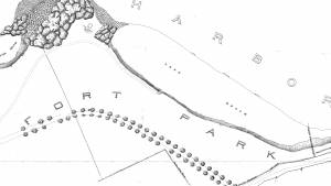
29 x 25 in.
Cape Ann Museum Library & Archive (#089)
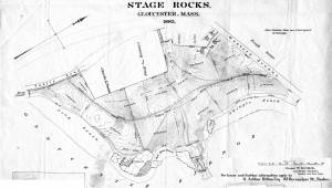
Ernest Bowditch was a landscape gardener. This map shows some of the various names of landmarks around Stage Rocks.
Also filed under: Field Beach / Crescent (or Cressy's) Beach / Long Beach » // Half Moon Beach » // Maps »
Ten Pound Island guards the entrance to Gloucester’s Inner Harbor and provides a crucial block to heavy seas running southerly down the Outer Harbor from the open ocean beyond. The rocky island and its welcoming lighthouse is seen, passed, and possibly blessed by every mariner entering the safety of Gloucester’s Inner Harbor after outrunning a storm at sea. Ten Pound Island is situated such that the Inner Harbor is protected from open water on all sides making it one of the safest harbors in all New England.
Legend has it that the island was named for the ten pound sum paid to the Indians for the island, and the smaller Five Pound Island deeper in the Inner Harbor was purchased for that lesser sum. None of it makes much financial sense when the entirety of Cape Ann was purchased for only seven pounds from the Indian Samuel English, grandson of Masshanomett the Sagamore of Agawam in 1700. From approximately 1640 on the island was used to hold rams, and anyone putting female sheep on the island was fined. Gloucester historian Joseph Garland has posited that the name actually came from the number of sheep pens it held, or pounds as they were called, and the smaller Five Pound Island was similarly named.
The island itself is only a few acres of rock and struggling vegetation but is central to the marine life of the harbor as it defines the eastern edge of the deep channel used to turn the corner and enter the Inner Harbor. The first lighthouse was lit there in 1821, and a house was built for the keeper adjacent to the lighthouse.
In the summer of 1880 Winslow Homer boarded with the lighthouse keeper and painted some of his most masterful and evocative watercolor views of the busy harbor life swirling about the island at all times of day. Boys rowing dories, schooners tacking in and out in all weather, pleasure craft drifting in becalmed water, seen together they tell a Gloucester story of light, water and sail much as Lane’s work did only several decades earlier.

Colored lithograph
Cape Ann Museum Library and Archive
Also filed under: Gloucester, Mass. - "Ten Pound Island Light »

Photograph
From The Illustrated Coast Pilot with Sailing Directions. The Coast of New England from New York to Eastport, Maine including Bays and Harbors, N. L. Stebbins, 1891.
Also filed under: Gloucester, Mass. - "Ten Pound Island Light »


Oil on canvas
22 x 36 in.
Cape Ann Museum, Gloucester, Mass., deposited by the Collection of Addison Gilbert Hospital, 1978 (DEP. 201)
Detail of party boat.
Also filed under: Party Boat »

Engraving of 1819 survey taken from American Coast Pilot 14th edition
9 1/2 x 8 in.
Cape Ann Museum Library & Archive
D32 FF5
Also filed under: Dolliver's Neck » // Eastern Point » // Maps » // Norman's Woe »
Newspaper
Gloucester Telegraph
"By the will of the late Fitz H. Lane, Esq., his handsome painting of the Old Fort, Ten Pound Island, etc., now on exhibition at the rooms of the Gloucester Maritime Insurance Co., was given to the town... It will occupy its present position until the town has a suitable place to receive it."

Stereograph card
Cape Ann Museum Library & Archive
View from top of Unitarian Church on Middle Street looking southeast, showing the Fort and Ten Pound Island. Tappan Block and Main Street buildings between Center and Hancock in foreground.
Also filed under: Fort (The) and Fort Point » // Unitarian Church / First Parish Church (Middle Street) »

1860 In John J. Babson, History of the Town Gloucester (Gloucester, MA: Procter Brothers, 1860) Cape Ann Museum Library & Archives, Gloucester, Mass.
See p. 474.
View related catalogue entries (4) »
Also filed under: Babson History of the Town of Gloucester » // Chebacco Boat / Dogbody / Pinky » // Fort (The) and Fort Point » // Gloucester Harbor, Inner / Harbor Cove » // Gloucester, Mass. - "Ten Pound Island Light » // Schooner (Coasting / Lumber / Topsail / Packet / Marsh Hay) »
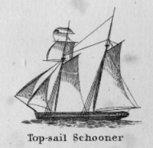
Schooners in Lane’s time were, with few exceptions, two-masted vessels carrying a fore-and-aft rig having one or two jibs, a fore staysail, gaff-rigged fore- and main sails, and often fore- and main topsails. One variant was the topsail schooner, which set a square topsail on the fore topmast. The hulls of both types were basically similar, their rigs having been chosen for sailing close to the wind. This was an advantage in the coastal trade, where entering confined ports required sailing into the wind and frequent tacking. The square topsail proved useful on longer coastwise voyages, the topsail providing a steadier motion in offshore swells, reducing wear and tear on canvas from the slatting of the fore-and-aft sails. (1)
Schooners of the types portrayed by Lane varied in size from 70 to 100 feet on deck. Their weight was never determined, and the term “tonnage” was a figure derived from a formula which assigned an approximation of hull volume for purposes of imposing duties (port taxes) on cargoes and other official levies. (2)
Crews of smaller schooners numbered three or four men. Larger schooners might carry four to six if a lengthy voyage was planned. The relative simplicity of the rig made sail handling much easier than on a square-rigged vessel. Schooner captains often owned shares in their vessels, but most schooners were majority-owned by land-based firms or by individuals who had the time and business connections to manage the tasks of acquiring and distributing the goods to be carried. (3)
Many schooners were informally “classified” by the nature of their work or the cargoes they carried, the terminology coined by their owners, agents, and crews—even sometimes by casual bystanders. In Lane’s lifetime, the following terms were commonly used for the schooner types he portrayed:
Coasting schooners: This is the most general term, applied to any merchant schooner carrying cargo from one coastal port to another along the United States coast (see Bar Island and Mt. Desert Mountains from Somes Settlement, 1850 (inv. 401), right foreground). (4)
Packet schooners: Like packet sloops, these vessels carried passengers and various higher-value goods to and from specific ports on regular schedules. They were generally better-maintained and finished than schooners carrying bulk cargoes (see The Old Fort and Ten Pound Island, Gloucester, 1850s (inv. 30), center; and Gloucester Inner Harbor, 1850 (inv. 240), stern view). (5)
Lumber schooners: Built for the most common specialized trade of Lane’s time, they were fitted with bow ports for loading lumber in their holds (see View of Southwest Harbor, Maine: Entrance to Somes Sound, 1852 (inv. 260)) and carried large deck loads as well (Stage Rocks and the Western Shore of Gloucester Outer Harbor, 1857 (inv. 8), right). Lumber schooners intended for long coastal trips were often rigged with square topsails on their fore masts (see Becalmed Off Halfway Rock, 1860 (inv. 344), left; ; and Lumber Schooner in a Gale, 1863 (inv. 552)). (6)
Schooners in other specialized trades. Some coasting schooners built for carrying varied cargoes would be used for, or converted to, special trades. This was true in the stone trade where stone schooners (like stone sloops) would be adapted for carrying stone from quarries to a coastal destination. A Lane depiction of a stone schooner is yet to be found. Marsh hay was a priority cargo for gundalows operating around salt marshes, and it is likely that some coasting schooners made a specialty of transporting this necessity for horses to urban ports which relied heavily on horses for transportation needs. Lane depicted at least two examples of hay schooners (see Gloucester Harbor, 1850s (inv. 391), left; and Coasting Schooner off Boon Island, c.1850 (inv. 564)), their decks neatly piled high with bales of hay, well secured with rope and tarpaulins.
– Erik Ronnberg
References:
1. Howard I. Chapelle, The History of American Sailing Ships (New York: W.W. Norton & Co., 1935), 258. While three-masted schooners were in use in Lane’s time, none have appeared in his surviving work; and Charles S. Morgan, “New England Coasting Schooners”, The American Neptune 23, no. 1 (DATE): 5–9, from an article which deals mostly with later and larger schooner types.
2. John Lyman, “Register Tonnage and its Measurement”, The American Neptune V, nos. 3–4 (DATE). American tonnage laws in force in Lane’s lifetime are discussed in no. 3, pp. 226–27 and no. 4, p. 322.
3. Ship Registers of the District of Gloucester, Massachusetts, 1789–1875 (Salem, MA: The Essex Institute, 1944). Vessels whose shipping or fishing voyages included visits to foreign ports were required to register with the Federal Customs agent at their home port. While the vessel’s trade or work was unrecorded, their owners and master were listed, in addition to registry dimensions and place where built. Records kept by the National Archives can be consulted for information on specific voyages and ports visited.
4. Howard I. Chapelle, The National Watercraft Collection (Washington, DC: Smithsonian Institution, 1960), 40, 42–43.
5. Ibid., 42–43, 73.
6. Ibid., 74–76.

In R. H. Dana, The Seaman's Friend, 13th ed. (Thomas Groom & Co. Publisher, 1873)
A topsail schooner has no tops at her foremast, and is fore-and-aft rigged at her mainmast. She differs from an hermaphrodite brig in that she is not properly square-rigged at her foremast, having no top, and carrying a fore-and-aft foresail instead of a square foresail and a spencer.

Detail views: marine railway and hauling cradle for vessel Wood rails, metal rollers, chain; wood cradle. Scale: ½" = 1' (1:24) Original diorama components made, 1892; replacements made, 1993. Cape Ann Museum, from Gloucester Chamber of Commerce, 1925 (2014.071)
A schooner is shown hauled out on a cradle which travels over racks of rollers on a wood and metal track.
Also filed under: Burnham Brothers Marine Railway » // Marine Railways »

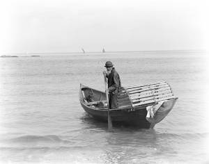
c. 1900 Glass plate negative Collection of Erik Ronnberg
Also filed under: Lobstering »
"The Maine Register for the Year 1855, embracing State and County Officers, and an abstract of the law and resolves; together with a complete business directory of the state, and a variety of useful information."
Details about Maine's lumber trade in 1855, see pp. 250–52
Also filed under: Castine » // Lumber Industry »
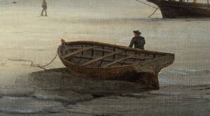
The yawl boat was a ninteenth-century development of earlier ships' boats built for naval and merchant use. Usually twenty feet long or less, they had round bottoms and square sterns; many had raking stem profiles. Yawl boats built for fishing tended to have greater beam than those built for vessels in the coastal trades. In the hand-line fisheries, where the crew fished from the schooner's rails, a single yawl boat was hung from the stern davits as a life boat or for use in port. Their possible use as lifeboats required greater breadth to provide room for the whole crew. In port, they carried crew, provisions, and gear between schooner and shore. (1)
Lane's most dramatic depictions of fishing schooners' yawl-boats are found in his paintings Gloucester Outer Harbor, from the Cut, 1850s (inv. 109) and /entry:311. Their hull forms follow closely that of Chapelle's lines drawing. (2) Similar examples appear in the foregrounds of Gloucester Harbor, 1852 (inv. 38), Ships in Ice off Ten Pound Island, Gloucester, 1850s (inv. 44), and The Fort and Ten Pound Island, Gloucester, Massachusetts, 1847 (inv. 271). A slightly smaller example is having its bottom seams payed with pitch in the foreground of Gloucester Harbor, 1847 (inv. 23). In Gloucester Inner Harbor, 1850 (inv. 240), a grounded yawl boat gives an excellent view of its seating arrangement, while fishing schooners in the left background have yawl boats hung from their stern davits, or floating astern.
One remarkable drawing, Untitled, n.d. (inv. 219) illustrates both the hull geometry of a yawl boat and Lane's uncanny accuracy in depicting hull form in perspective. No hull construction other than plank seams is shown, leaving pure hull form to be explored, leading in turn to unanswered questions concerning Lane's training to achieve such understanding of naval architecture.
– Erik Ronnberg
References:
1. Howard I. Chapelle, American Small Sailing Craft (New York: W.W. Norton & Co., 1951), 222–23.
2. Ibid., 223.
Oil on canvas
12 1/8 x 19 3/4 in.
Museum of Fine Arts, Boston, Bequest of Martha C. Karolik for the M.and M. Karolik Collection of American Paintings, 1815-1865 (48.447)
A schooner's yawl lies marooned in the ice-bound harbor in this detail.

Prior to 1840, the lobster fishery had but a minor role in the American fishing industry. The market was limited by the difficulties of transporting live lobsters over long distances, which kept the demand local. As transportation (by rail), improved, the market broadened and demand increased, leading to more fishing and reduction of lobsters, both in size and in numbers.
In Lane's later years, the fishery was growing, but significant decreases of lobsters were not yet considered serious. Decrease in numbers of very large lobsters (weighing ten pounds or more) was noted, but clamors for regulations on sizes and numbers of lobsters caught were not heard until the 1870s.
Lobster traps in the nineteenth century were mostly of the "round top" design—built of wooden laths with funnel-shaped entries of netting at both ends. The tops were hinged "lids" providing access to the catch; stones were fitted as weights to the flat bottom.
The pots could be set individually or in "strings" with marker buoys at both ends of the string. Individual pots were set on rocky bottom where a string of pots could become fouled and lost. Strings of pots were best for a smooth bottom when lobsters were moving inshore in large numbers. When lobsters were scarce on smooth bottoms, individual pots were set, being easier to move to other places.
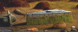
Once caught, lobsters were kept in floating boxes (called "cars") with open seams and bored holes to allow water to circulate. A lobster car with a "killick" (stone anchor) is depicted by Lane in the foreground of Gloucester Inner Harbor, 1850 (inv. 240).
– Erik Ronnberg
Reference:
G. Brown Goode, "Fisheries and Fishery Industries", Section V, Vol. 2, 658–74.
In G. Brown Goode, The Fisheries and Fishery Industries of the United States (Washington, DC: Government Printing Office)
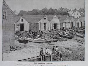
Cape Ann Museum Library & Archive, Gloucester, Mass.
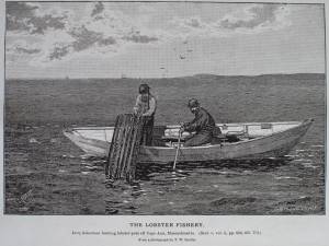
See pl. 247.
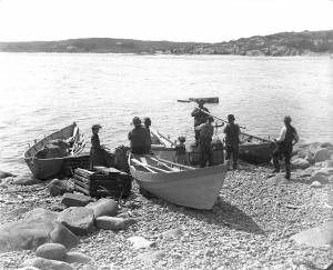
This photo was most likely taken in Ipswich Bay on the north shore of Cape Ann (visible in right background). During the warm months, lobsters migrate to the shore where they feed and shed their outgrown shells while hiding among the rocks. Dories are the lobstermen's choice for working traps out in the bay or close to shore in rocky shallows. Pots can be set individually or in strings, the latter on smoother ground where the line is less likely to be fouled.
– Erik Ronnberg
Gloucester Inner Harbor
Oil on canvas
24 x 36 in. (61 x 91.4 cm)
The lobster car was a floating holding tank for lobsters that were kept in the harbor prior to local sale or transportation to fish markets in Boston.
In G. Brown Goode, The Fisheries and Fishery Industries of the United States (Washington, DC: Government Printing Office)
Cape Ann Museum Library & Archive, Gloucester, Mass.
See pl. 249.
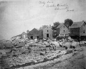
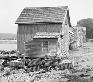
Lobster Cove (Lane's Cove) was a thriving port for the Ipswich Bay shore fisheries from colonial times through the 19th century. Even as late as the mid-20th century, the waterfront was lined with sheds for fishing gear - now all gone. In addition to lobstering, gill-netting, trap fishing, hand-lining, and seining (small-scale) were carried on at various times in pursuit of numerous fish and shellfish types.
– Erik Ronnberg
Also filed under: Folly Cove »
Glass plate negative
4 x 5 in.
Cape Ann Museum Library & Archive
#10205/418
Also filed under: Folly Cove »
c. 1900 Glass plate negative Collection of Erik Ronnberg
Also filed under: Schooner (Coasting / Lumber / Topsail / Packet / Marsh Hay) »