An online project under the direction of the CAPE ANN MUSEUM
Catalogue Entry
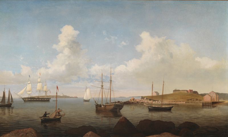
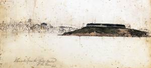
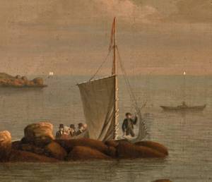
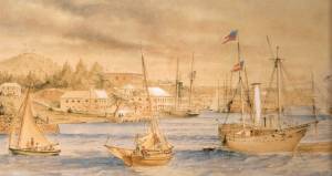
This painting and its possible color sketch The Old Fort and Ten Pound Island, Gloucester, 1850s (inv. 28) depict Gloucester's Harbor Cove as it looked in the early 1840s. The artist's viewing point was on Duncan Street, on partially filled waterfront which became Fear's Wharf. Rocks were still visible along the shore at low tide. The painting's right margin barely captures the wharf and adjoining bulkhead pier of John W. Lowe. The left margin includes most of Black Rock off the west end of Rocky Neck, Black Bess Rock beyond it, and most distant, the westernmost tip of Eastern Point.
The left-center background depicts Ten Pound Island and its lighthouse; the middle-right far background includes Norman's Woe Rock and Mussel Point. The middle ground, from center to right margin, is dominated by Fort Point, which is connected to the Gloucester mainland by Pavilion Beach (not visible). Atop Fort Point are the remains of Fort Defiance; to its left is a small building identified on some town maps as a bowling alley. Harbor Cove, enclosed by Fort Point and Duncan's Point, provided Gloucester's most important wharfage for merchant and fishing vessels prior to 1865.
For all its importance, Harbor Cove was too shallow and confined for anchoring or berthing large vessels for any purpose but loading and unloading. They were forced to anchor in the Outer Harbor. The most convenient area was called "the Stream"—deep water between Rocky Neck and Duncan's Point and westward, past Ten Pound Island and Fort Point.
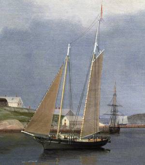
The vessels depicted include two pinkies (far left and farthest right), a merchant ship (left background), a packet schooner (center), a merchant sloop (center left), and a sloop-rigged party boat. The pinkies were small schooner-rigged fishing vessels—an obsolete type by 1840, but so well constructed that many lasted through the nineteenth century. Lane might have chosen them to symbolize the midcentury decline in Gloucester's fisheries in favor of the foreign trade, exemplified here by the large merchant ship.
While focused on trade with Surinam, Gloucester's merchants also sent their ships, barks, and brigs to the West Indies, Europe, and India—activity which had peaked by 1850 and ended by 1860. Harbor Cove proved too small and shallow to accommodate the ever-larger vessels, forcing merchants to move their ships and facilities to Boston, or go back to fishing.
The packet schooner and merchant sloop symbolize a constantly busy coastal trade up and down the Atlantic coast, from Canada to the West Indies. The fore-and-aft rigs (sloops and schooners) were best suited to deal with adverse winds while avoiding dangerous shorelines and other hazards to navigation. The better classes of these rigs were packets, sailing on regular schedules between specified ports, carrying mail, passengers, and smaller quantities of merchandise (bulk and high-value) to meet the limited demands of smaller coastal communities.
– Erik Ronnberg
- Subject Types
: - Vessel Types
: - Cape Ann Locales
: - Objects
: - Building Types
:
Historical Materials
Newsprint
From bound volume owned by publisher Francis Procter
Collection of Fred and Stephanie Buck
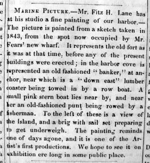
"MARINE PICTURE – Mr. Fitz H. Lane has at his studio a fine painting of our harbor. – The picture is painted from a sketch taken in 1843, from the spot now occupied by Mr Fears' new wharf. It represents the old fort as it was at that time, before any of the present buildings were erected; in the harbor cove is represented an old fashioned 'banker,' at anchor, near which is a 'down east' lumber coaster being towed in by a row boat. A small pink stern boat lies near by, and near her an old-fashioned punt being rowed by a fisherman. To the left of these is a view of the Island, and a brig with sail set preparing to get underweigh. The painting reminds one of days agone, and it is one of the Artist's first productions. We hope to see it on exhibition ere long in some public place."

Oil on canvas
22 x 36 in.
Cape Ann Museum, Gloucester, Mass., deposited by the Collection of Addison Gilbert Hospital, 1978 (DEP. 201)
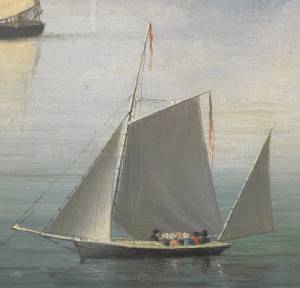
Detail of party boat.
Filed under: Party Boat » // Ten Pound Island »

1860 In John J. Babson, History of the Town Gloucester (Gloucester, MA: Procter Brothers, 1860) Cape Ann Museum Library & Archives, Gloucester, Mass.
See p. 474.
View related catalogue entries (4) »
Filed under: Babson History of the Town of Gloucester » // Chebacco Boat / Dogbody / Pinky » // Fort (The) and Fort Point » // Gloucester Harbor, Inner / Harbor Cove » // Gloucester, Mass. - "Ten Pound Island Light » // Schooner (Coasting / Lumber / Topsail / Packet / Marsh Hay) » // Ten Pound Island »
George H. Rogers was one of Gloucester's most enterprising citizens of the mid-nineteenth century. In the early 1830s, he ventured into the Surinam trade with great success, leading him to acquire a wharf at the foot of Sea Street. Due to Harbor Cove's shallow bottom at low tide, berthings at wharves had to be done at high tide, leaving the ships grounded at other times. Many deep-loaded vessels had to anchor outside Harbor cove and be partially off-loaded by "lighters" (shallow-draft vessels that could transfer cargo to the wharves) before final unloading at wharfside. To lessen this problem, Rogers had an unattached extension built out from his wharf into deeper water (see The Fort and Ten Pound Island, Gloucester (Harbor Scene), 1848 (inv. 58), right middle ground). The space between the old wharf and the extension may have been a way to evade harbor regulations limiting how far a pier head could extend into the harbor. Stricter rules were not long in coming after this happened!
About 1848, Rogers acquired land on the east end of Fort Point, first putting up a large three-story building adjacent to Fort Defiance, then a very large wharf jutting out into Harbor Cove. Lane's depictions of Harbor Cove and Fort Point show progress of this construction in 1848 (The Fort and Ten Pound Island, Gloucester (Harbor Scene), 1848 (inv. 58)), 1850 (Gloucester Inner Harbor, 1850 (inv. 240)), and c.1851 (Gloucester Harbor at Dusk, c.1852 (inv. 563)). A corner of the new wharf under construction can also be seen more closely in Ten Pound Island, Gloucester, 1850s (inv. 17) and Ten Pound Island in Gloucester Harbor, 1864 (inv. 104) (foregrounds). This new wharf provided better frontage for large ships to load and unload, as well as larger warehouses and lofts for storage of goods and vessel gear.
By 1860, Rogers was unloading his Surinam cargos at Boston, as ever-larger ships and barks were more easily berthed there. His Gloucester wharves continued to be used for deliveries of trade goods by smaller vessels. In the late 1860s, Rogers' wharf at Fort Point (called "Fort Wharf" in Gloucester directories) was acquired by (Charles D.) Pettingill & (Nehemiah) Cunningham for use in "the fisheries" as listed by the directory. in 1876, it was sold to (John J.) Stanwood & Company, also for use in "the fisheries." (1)
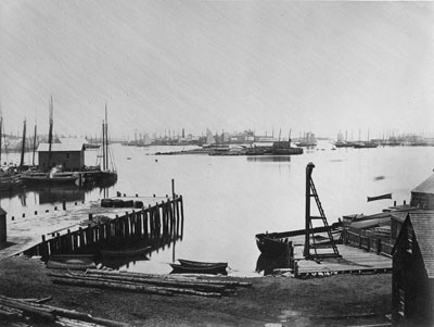
Lowe's Wharf, adjacent to Fort Wharf, was acquired by (Sylvester) Cunningham & (William) Thompson, c.1877 and used in "the fisheries" as well. That wharf and its buildings were enlarged considerably as the business grew. By this time, Harbor Cove was completely occupied by businesses in the fisheries or providing services and equipment to the fishing fleet. In photographs of Fort Point from this period, it is difficult to distinguish one business from another, so closely are they adjoined.
– Erik Ronnberg
Reference:
1. A city atlas, dated 1899, indicates that Rogers's wharf at Fort Point was still listed as part of his estate. If so, then Stanwood & Co. would have been leasing that facility from the Rogers's estate.
44 x 34 in.
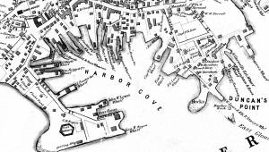
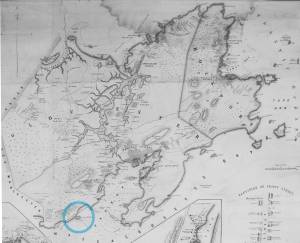
Henry Francis Walling, Map of the Towns of Gloucester and Rockport, Essex Co. Massachusetts. Philadelphia, A. Kollner, 1851
Cape Ann Museum Library & Archive
"Map of the Towns of Gloucester and Rockport, Massachusetts. H.F. Walling, Civil Engineer. John Hanson, Publisher. 1851. Population of Gloucester in 1850 7,805. Population of Rockport in 1850 3,213."
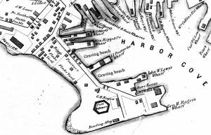
Segment of Harbor Village portion of map showing Low's, Rogers', and other wharves in the Inner Harbor.
Also filed under: Low (Frederick G.) wharves »
44 x 34 in.
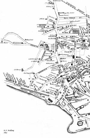
Henry Francis Walling, Map of the Towns of Gloucester and Rockport, Essex Co. Massachusetts. Philadelphia, A. Kollner, 1851
Cape Ann Museum Library & Archive
"Map of the Towns of Gloucester and Rockport, Massachusetts. H.F. Walling, Civil Engineer. John Hanson, Publisher. 1851. Population of Gloucester in 1850 7,805. Population of Rockport in 1850 3,213."

44 x 34 in.
John Hanson, Publisher
Cape Ann Museum Library & Archive
"Map of the Towns of Gloucester and Rockport, Massachusetts. H.F. Walling, Civil Engineer. John Hanson, Publisher. 1851. Population of Gloucester in 1850 7,805. Population of Rockport in 1850 3,213."
Also filed under: Fort (The) and Fort Point » // Low (Frederick G.) wharves » // Maps » // Town / Public Landings » // Waterfront, Gloucester » // Windmill »

1865 41 x 29 inches Courtesy of the Massachusetts Archives Maps and Plans, Third Series Maps, v.66:p.1, no. 2352, SC1/series 50X
.
Also filed under: Burnham Brothers Marine Railway » // Collins's, William (estate wharf) » // Gloucester Harbor, Inner / Harbor Cove » // Maps »

1876 Photograph Cape Ann Museum Library & Archive
Ignatius Weber's windmill (now defunct) is shown.
Also filed under: Flake Yard » // Fort (The) and Fort Point » // Gloucester Harbor, Inner / Harbor Cove » // Historic Photographs » // Schooner (Fishing) » // Waterfront, Gloucester » // Windmill »
Through the years, this point and its fortifications had many names: Watch House Point, the Old Battery, Fort Defiance, Fort Head, and now just "The Fort." In 1793, Fort Defiance was turned over to the young United States government and was allowed to deteriorate. During the War of 1812 it was described as being "in ruins," and any remaining buildings burned in 1833. It was resuscitated in the Civil War and two batteries of guns were installed. The City of Gloucester did not regain ownership of the land until 1925.
The first fortifications on this point, guarding the entrance to the Inner Harbor, were put up in the 1740s, when fear of attack from the French led to the construction of a battery armed with twelve-pounder guns. Greater breastworks were thrown up in 1775, after Capt. Lindsay and his sloop-of-war the "Falcon" attacked the unprepared town. They were small and housed only a few cannon and local soldiers. Several other fortifications were at various times erected around the harbor: Fort Conant at what is now Stage Fort Park, another on Duncan's Point (near site of Lane's house) and the Civil War fort on Eastern Point. None of these preparations was ever called upon to actually defend the town.
Lane during his lifetime created a long series of images of the point and the condition of its fortifications. In 1832 there were still buildings standing, and the point had not yet been used for major wharves and warehouses. By the time of his painting Gloucester Harbor, 1852 (inv. 38), one can see that the earthwork foundation, but no superstructures, survived.
– Sarah Dunlap
1860 In John J. Babson, History of the Town Gloucester (Gloucester, MA: Procter Brothers, 1860) Cape Ann Museum Library & Archives, Gloucester, Mass.
See p. 474.
View related catalogue entries (4) »
Also filed under: Babson History of the Town of Gloucester » // Chebacco Boat / Dogbody / Pinky » // Gloucester Harbor, Inner / Harbor Cove » // Gloucester, Mass. - "Ten Pound Island Light » // Schooner (Coasting / Lumber / Topsail / Packet / Marsh Hay) » // Ten Pound Island »
Newsprint
Gloucester Telegraph
About picture of Old Fort hanging in the Gloucester Bank: "This picture is chiefly of interest on account of its preserving so accurately the features of a view so familiar to many of our citizens and which can never exist in reality."
Also filed under: Chronology » // Gloucester Bank » // Gloucester, Mass. – Gloucester Bank » // Newspaper / Journal Articles »

24 x 38 in.
Gloucester City Archives
"Drawn on a scale of one hundred feet to an inch. By John Mason 1834–45 from Actual Survey showing every Lott and building then standing on them giving the actual size of the buildings and width of the streets from the Canal to the head of the Harbour & part of Eastern point as farr as Smith's Cove and the Shore of the same with all the wharfs then in use. Gloucester Harbor 1834–35."
This map is especially useful in showing the Fort.
Also filed under: Flake Yard » // Maps » // Mason, John » // Pavilion (Publick) Beach » // Town / Public Landings »
44 x 34 in.
John Hanson, Publisher
Cape Ann Museum Library & Archive
"Map of the Towns of Gloucester and Rockport, Massachusetts. H.F. Walling, Civil Engineer. John Hanson, Publisher. 1851. Population of Gloucester in 1850 7,805. Population of Rockport in 1850 3,213."
Also filed under: Low (Frederick G.) wharves » // Maps » // Rogers's (George H.) wharves » // Town / Public Landings » // Waterfront, Gloucester » // Windmill »
Newsprint
Cape Ann Advertiser
Cape Ann Museum Library & Archive
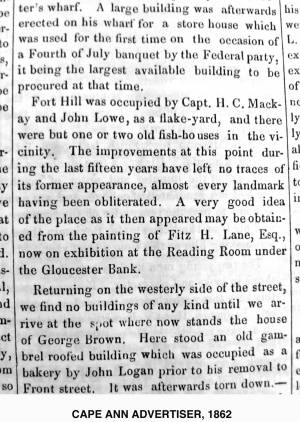
"Fort Hill was occupied by Capt. H. C. Mackay and John Lowe, as a flake-yard, and there were but one or two old fish-houses in the vicinity. The improvements at this point during the last fifteen years have left no traces of its former appearance, almost every landmark having been obliterated. A very good idea of the place as it then appeared may be obtained from the painting of Fitz H. Lane, Esq., now on exhibition at the Reading Room under the Gloucester Bank."
Also filed under: Gloucester Bank » // Newspaper / Journal Articles »
Newspaper
Gloucester Telegraph
"By the will of the late Fitz H. Lane, Esq., his handsome painting of the Old Fort, Ten Pound Island, etc., now on exhibition at the rooms of the Gloucester Maritime Insurance Co., was given to the town... It will occupy its present position until the town has a suitable place to receive it."
Also filed under: Funeral & Burial » // Gloucester, Mass. – Marine Insurance Company » // Newspaper / Journal Articles » // Ten Pound Island »
Newsprint
Gloucester Telegraph
At the dedication of the Town House, speaker, "read the following letter:
To the Selectmen of Gloucester: / Gents: The will of our late Townsman, Fitz. H. Lane, contains this provision: / I give to the inhabitants of the Town of Gloucester, the picture of the Old Fort, to be kept as a memento[sic] of one of the localities of olden time; the said picture now hanging in the Reading Room under the Gloucester Bank, and to be there kept until the Town of Gloucester shall furnish a suitable and safe place to hang it. / The original sketch was taken twenty-five years ago, but the boats and vessels introduced are those of a quarter of a century earlier still. The painting was executed in 1859, six years before his decease."
Also filed under: Documents / Objects » // Newspaper / Journal Articles » // Town House »

Stereograph card
Cape Ann Museum Library & Archive
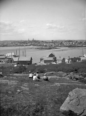
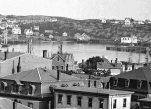
View from top of Unitarian Church on Middle Street looking southeast, showing the Fort and Ten Pound Island. Tappan Block and Main Street buildings between Center and Hancock in foreground.
Also filed under: Ten Pound Island » // Unitarian Church / First Parish Church (Middle Street) »
1876 Photograph Cape Ann Museum Library & Archive
Ignatius Weber's windmill (now defunct) is shown.
Also filed under: Flake Yard » // Gloucester Harbor, Inner / Harbor Cove » // Historic Photographs » // Rogers's (George H.) wharves » // Schooner (Fishing) » // Waterfront, Gloucester » // Windmill »
The northeast quarter of Gloucester Harbor is an inlet bounded by Fort Point and Rocky Neck at its entrance. It is further indented by three coves: Harbor Cove and Vincent’s Cove on its north side, and Smith’s Cove on its south side. The shallow northeast end is called Head of the Harbor. Collectively, this inlet with its coves and shallows is called Inner Harbor.
The entrance to Inner Harbor is a wide channel bounded by Fort Point and Duncan’s Point on its north side, and by Rocky Neck on its south side. From colonial times to the late nineteenth century, it was popularly known as “the Stream” and served as anchorage for deeply loaded vessels for “lightering” (partial off-loading). Subsequently it was known as “Deep Hole.”
Of Inner Harbor’s three coves, Harbor Cove (sometimes called “Old Harbor” in later years) was the deepest and most heavily used by fishing vessels in the Colonial Period, and largely dominated by the foreign trade in the first half of the nineteenth century. Its shallow bottom was the undoing of the foreign trade, as larger vessels became too deep to approach its wharves, and the cove returned to servicing a growing fishing fleet in the 1850s.
Vincent’s Cove, a smaller neighbor to Harbor Cove, was bare ground at low tide, and mostly useless for wharfage. Its shoreline was well suited for shipbuilding, and the cove was deep enough at high tide for launching. Records of shipbuilding there prior to the early 1860s have to date not been found.Smith’s Cove afforded wharfage for fishing vessels at its east entrance, as seen in Lane’s lithograph View of the Town of Gloucester, Mass., 1836 (inv. 86). The rest of the cove saw little use until the expansion of the fisheries after 1865.
The Head of the Harbor begins at the shallows surrounding Five Pound Island, extending to the harbor’s northeast end. Lane’s depiction of this area in Gloucester Harbor, 1847 (inv. 23) shows the problems faced by vessel owners at low tide. Despite the absence of deep water, this area saw rapid development after 1865 when a thriving fishing industry needed waterfront facilities, even if they were accessible only at high tide.
– Erik Ronnberg

c.1870 Cape Ann Museum Library & Archive (2013.068)
Schooner fleet anchored in the inner harbor. Looking east from Rocky Neck, Duncan's Point wharves and Lane house (at far left), Sawyer School cupola on Friend Street.
Also filed under: Duncan's Point » // Historic Photographs » // Schooner (Fishing) » // Waterfront, Gloucester »
1876 Photograph Cape Ann Museum Library & Archive
Also filed under: Historic Photographs » // Schooner (Fishing) » // Waterfront, Gloucester »

1851 44 x 34 in. Henry Francis Walling, Map of the Towns of Gloucester and Rockport, Essex Co. Massachusetts. Philadelphia, A. Kollner, 1851 Cape Ann Museum Library & Archive
"Map of the Towns of Gloucester and Rockport, Massachusetts. H.F. Walling, Civil Engineer. John Hanson, Printer. 1851. Population of Gloucester in 1850 7,805. Population of Rockport in 1850 3,213."
Also filed under: Baptist Church (Old, First, 1830) (Pleasant Street) » // Burnham Brothers Marine Railway » // Duncan's Point » // Five Pound Island » // Flake Yard » // Harbor Methodist Church (Prospect Street) » // Low (Frederick G.) wharves » // Pavilion Hotel » // Procter Brothers » // Ropewalk » // Vincent's Cove » // Western Shore »

4 x 6 in.
Cape Ann Museum, Benham Collection
George Steele sail loft, William Jones spar yard, visible across harbor. Photograph is taken from high point on the Fort, overlooking business buildings on the Harbor Cove side.
Also filed under: Fort (The) and Fort Point » // Town House » // Universalist Church (Middle and Church Streets) » // Waterfront, Gloucester »


1834–35 Lithograph 24 x 38 in. Gloucester City Archives
"Drawn on a scale of one hundred feet to an inch. By John Mason 1834–45 from Actual Survey showing every Lott and building then standing on them giving the actual size of the buildings and width of the streets from the Canal to the head of the Harbour & part of Eastern point as farr as Smith's Cove and the Shore of the same with all the wharfs then in use. Gloucester Harbor 1834–35."
This map shows the location of F. E. Low's wharf and the ropewalk. Duncan's Point, the site where Lane would eventually build his studio, is also marked.
The later notes on the map are believed to be by Mason.
Also filed under: Duncan's Point » // Low (Frederick G.) wharves » // Low, Capt. Frederick Gilman » // Maps » // Mason, John » // Residences » // Ropewalk » // Somes, Capt. John »
44 x 34 in.
Henry Francis Walling, Map of the Towns of Gloucester and Rockport, Essex Co. Massachusetts. Philadelphia, A. Kollner, 1851
Cape Ann Museum Library & Archive
"Map of the Towns of Gloucester and Rockport, Massachusetts. H.F. Walling, Civil Engineer. John Hanson, Publisher. 1851. Population of Gloucester in 1850 7,805. Population of Rockport in 1850 3,213."
Segment of Harbor Village portion of map showing Collins' and other wharves in the Inner Harbor.
Also filed under: Graving Beach »

Collection of Erik Ronnberg
View related catalogue entries (2) »
Also filed under: Dolliver's Neck » // Fresh Water Cove » // Gloucester Harbor, Outer » // Maps »
1865 41 x 29 inches Courtesy of the Massachusetts Archives Maps and Plans, Third Series Maps, v.66:p.1, no. 2352, SC1/series 50X
.
Also filed under: Burnham Brothers Marine Railway » // Collins's, William (estate wharf) » // Maps » // Rogers's (George H.) wharves »
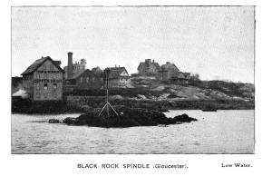
Photograph in The Illustrated Coast Pilot with Sailing Directions. The Coast of New England from New York to Eastport, Maine including Bays and Harbors, published by N. L. Stebbins, Boston
Also filed under: Beacons / Monuments / Spindles »
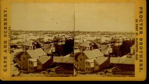
Stereograph card Cape Ann Museum Library & Archive
Also filed under: Gloucester – City Views » // Historic Photographs »
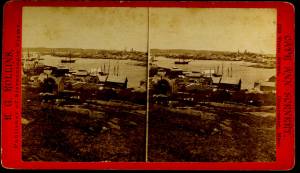
c.1870s Stereograph card Cape Ann Museum Library & Archive
From East Gloucester looking towards Gloucester.
Also filed under: Gloucester – City Views » // Historic Photographs »
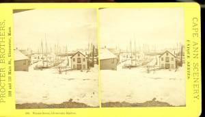
1876 Stereograph card Cape Ann Museum Library & Archive
Stereo view showing Gloucester Harbor after a heavy snowfall
Also filed under: Historic Photographs » // Waterfront, Gloucester »
Cape Ann Museum Library & Archive
Five Pound Island and Gloucester inner harbor taken from the top of Hammond Street building signs in foreground are for Severance, Carpenter and Crane, and Cooper at Clay Cove.
Also filed under: Five Pound Island »
1852
Oil on canvas
28 x 48 1/2 in.
Cape Ann Museum, Gloucester, Mass., Deposited by the City of Gloucester, 1952. Given to the city by Mrs. Julian James in memory of her grandfather Sidney Mason, 1913 (DEP. 200)
Detail of fishing schooner.
Also filed under: Schooner (Fishing) »
Oil on canvas
34 x 45 3/4 in.
Cape Ann Museum, Gloucester, Mass., Gift of Mrs. Jane Parker Stacy (Mrs. George O. Stacy),1948 (1289.1a)
Detail of party boat.
Also filed under: Party Boat »
c.1869 Glass plate negative Cape Ann Museum Library & Archive Detail from CAHA#00279
The magnificent views of Gloucester Harbor and the islands from the top floor of the stone house at Duncan's Point where Lane had his studio were the inspiration for many of his paintings.
From Buck and Dunlop, Fitz Henry Lane: Family, and Friends, pp. 59–74.
Also filed under: Duncan's Point » // Lane's Stone House, Duncan's Point » // Residences »
Glass plate negative
3 x 4 in.
Cape Ann Museum Library & Archive
#10112
Also filed under: Chebacco Boat / Dogbody / Pinky »
1876 Photograph Cape Ann Museum Library & Archive
Ignatius Weber's windmill (now defunct) is shown.
Also filed under: Flake Yard » // Fort (The) and Fort Point » // Historic Photographs » // Rogers's (George H.) wharves » // Schooner (Fishing) » // Waterfront, Gloucester » // Windmill »
1860 In John J. Babson, History of the Town Gloucester (Gloucester, MA: Procter Brothers, 1860) Cape Ann Museum Library & Archives, Gloucester, Mass.
See p. 474.
View related catalogue entries (4) »
Also filed under: Babson History of the Town of Gloucester » // Chebacco Boat / Dogbody / Pinky » // Fort (The) and Fort Point » // Gloucester, Mass. - "Ten Pound Island Light » // Schooner (Coasting / Lumber / Topsail / Packet / Marsh Hay) » // Ten Pound Island »
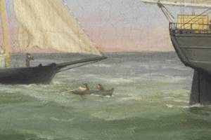
Gloucester Outer Harbor served as a staging area for deep draft or heavily laden vessels waiting to come into the wharves in the shallow Old Harbor at high tide, or waiting to discharge cargo into smaller vessels. While Lane's paintings typically show one or two vessels in the harbor, works by other artists from the period, as well as contemporary descriptions, demonstrate that the harbor was usually crowded with vessels, especially in bad weather. The Outer Harbor could accommodate as many as three hundred vessels when they needed to shelter during a storm.
There were two deep spots where they could wait, the "Deep Hole" between Ten Pound Island and the Fort; and the "Pancake Grounds" between Ten Pound Island and Eastern Point. The "Pancake Grounds" also served as a quarantine area for ships arriving from foreign ports. "Deep Hole" was named for the (relatively) deep water between Rocky Neck and Fort Point to the Outer Harbor. Deeply loaded vessels had to anchor there for “lightering” (partial unloading by boats called “lighters”) prior to final unloading at wharfside. "Deep Hole" was 20–25 feet deep at low tide, when Harbor Cove was only 1–6 feet deep with bare ground around some wharves. "Deep Hole" is where you see ships anchored in Gloucester Harbor from Rocky Neck, 1844 (inv. 14), The Old Fort and Ten Pound Island, Gloucester, 1850s (inv. 30), , Gloucester Inner Harbor, 1850 (inv. 240), The Fort and Ten Pound Island, Gloucester, Massachusetts, 1847 (inv. 271), and Gloucester Harbor, 1848 (inv. 335) (which is coming to anchor).
The term "Deep Hole" is apparently a post-Bellum term. Prior to that, it was known as "The Stream" and, as later, served as anchorage where deeply loaded vessels could be lightered prior to docking in Harbor Cove. Alfred Mansfield Brooks in his book Gloucester Recollected uses this term on page 53. After the Civil War, merchant shipping in Gloucester was dominated by salt ships and later coal carriers, bringing a whole new culture to the harbor, and with it new names for old places.

John Heywood Photo for Hervey Friend
Cape Ann Museum Library & Archive (2013.068)
Schooners anchored on the Pancake Ground, taken from from Wonson's Cove, easterly side of the Rocky Neck causeway. Eastern Point Fort and garrison in background to far left.
Also filed under: Eastern Point »

c.1870 Stereograph card Procter Brothers, Publisher Cape Ann Museum Library & Archive
"Gloucester Harbor from Rocky Neck, Looking Southwest. This gives a portion of the Harbor lying between Ten Pound Island and Eastern Point. At the time of taking this picture the wind was from the northeast, and a large fleet of fishing and other vessels were in the harbor. In the range of the picture about one hundred vessels were at anchor. In the small Cove in the foreground quite a number of dories are moored. Eastern Point appears on the left in the background."
Southeast Harbor was known for being a safe harbor.
Also filed under: Historic Photographs » // Rocky Neck » // Schooner (Fishing) » // Small Craft – Wherries, and Dories »
Collection of Erik Ronnberg
View related catalogue entries (2) »
Also filed under: Dolliver's Neck » // Fresh Water Cove » // Gloucester Harbor, Inner / Harbor Cove » // Maps »

c.1870 Stereograph card Procter Brothers, Publisher Cape Ann Museum Library & Archive
View from Civil War fort on Eastern Point.
Also filed under: Eastern Point » // Historic Photographs »

44 x 34 in.
Henry Francis Walling, Map of the Towns of Gloucester and Rockport, Essex Co. Massachusetts. Philadelphia, A. Kollner, 1851
Cape Ann Museum Library & Archive
"Map of the Towns of Gloucester and Rockport, Massachusetts. H.F. Walling, Civil Engineer. John Hanson, Publisher. 1851. Population of Gloucester in 1850: 7,805. Population of Rockport in 1850: 3,213."
Also filed under: Annisquam River » // Brookbank » // Dolliver's Neck » // Fresh Water Cove » // Maps » // Norman's Woe » // Stage Rocks / Stage Fort / Stage Head » // Steepbank » // West Gloucester – Little River » // Western Shore »
Newsprint
Cape Ann Advertiser
Cape Ann Museum Library & Archive
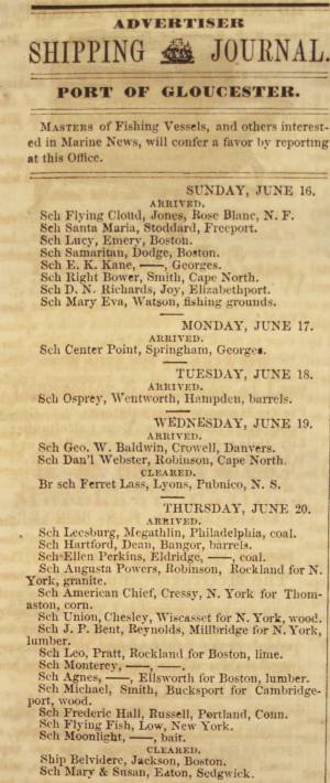
Notice in the Cape Ann Advertiser announcing arrival of ships into the port of Gloucester, with details of their cargo.
Also filed under: Newspaper / Journal Articles » // Trade Routes and Statistics »
Newspaper
"Lane's studio seldom presents so many attractions to visitors as at the present time. With unwonted rapidity his easel has turned off pictures in answer to the numerous orders which have poured in from all quarters."
Also filed under: Chronology » // Newspaper / Journal Articles » // Studio Descriptions »
Electrotype impression
Collection of Erik Ronnberg
Also filed under: Gloucester Harbor, Inner / Harbor Cove » // Maps »

c.1870 Stereograph card Procter Brothers, Publisher Cape Ann Museum Library & Archive
Also filed under: Historic Photographs » // Stage Rocks / Stage Fort / Stage Head »

Pencil and ink on paper
15 x 22 1/8 in.
Cape Ann Museum, Gloucester, Mass., Gift of Mr. Donald K. Usher, in memory of Mrs. Margaret Campbell Usher, 1984 (2401.19)
Also filed under: Beacons / Monuments / Spindles » // Mackerel Fishing »

Watercolor on paper
8 3/4 x 19 3/4 in.
Cape Ann Museum, Gloucester, Mass., Gift of Rev. and Mrs. A. A. Madsen, 1950
Accession # 1468
Fishing schooners in Gloucester's outer harbor, probably riding out bad weather.
Also filed under: Elwell, D. Jerome » // Schooner (Fishing) »
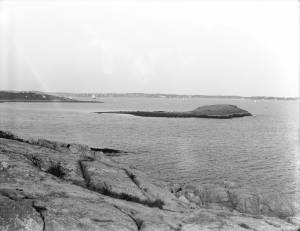
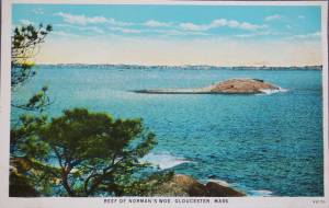
Norman’s Woe is a large rock sitting a few hundred feet off the western shore of Gloucester harbor. It lies between Gloucester and Magnolia and is just outside the confines of the harbor, if Eastern Point is used as the defining southern extent of the protected water. It can be reached from the shore at low tide over the rocks and is an island at high tide.
Tradition has it that a man named Norman was shipwrecked and lost there, but there is no historical record to substantiate it. Henry Wadsworth Longfellow memorialized it in his famous poem "The Wreck of the Hesperus" in 1840 though he never laid eyes on the rock until many years after he wrecked the Hesperus on it. His inspiration may have come from the wreck of the ship "Favorite" from Wiscasset, Maine on Norman’s Woe during the great blizzard of 1839. All hands were lost, one of whom was a woman who was found dead still tied to the mast which had floated ashore.
Because it lies outside the protection of the easterly arm of Eastern Point, Norman’s Woe and the surrounding rocky coast take the brunt of huge waves rolling in from the open ocean to the east, particularly after a storm. The high hills behind that western shore act as a wind block while tide and waves push a craft shoreward making Norman’s Woe the site of numerous shipwrecks and much loss of life through the years.
Lane did a drawing and some number of paintings of the site. He drew the rock from the shore looking to the south. Instead of the violent seas for which that shore is known he depicted it in a glassy calm. One of his landmark late paintings The Western Shore with Norman's Woe, 1862 (inv. 18) shows a boat drifting idly in the still late afternoon light in the cove just to the north of the rock of Norman’s Woe.
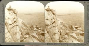
c.1860 Stereograph card Cape Ann Museum Library & Archive
Stereo View: "Geography – Norman's Woe is a headland on the mainland of Massachusetts just south of Gloucester Harbor, which is directly before us here. That very small island, to the left of the cliff, is called Norman's Woe Rock. Both places are so named because of the shipwreck of some member of the Norman family,who were among the early settlers in this locality.
Geology – The irregular jointing shows very clearly along the face of this cliff, where the action of the wind and weathering have cleared away the loose particles between the joints. The reason these rocks have withstood the destructive action of the erosion and weathering is because they are formed cheifly of felspar; in fact, this is a dike of that material.
Literature - Longfellow's poem, "The Wreck of the Hesperus," has immortalized the traditions that centre about these shores. The pounding of the waves uon this rock-bound promontory, and the dismal howling of the wind at this point, furnished him with the inspiration needed for his most favored masterpiece.
People and Homes - Seated upon our left is a very typical New England gentlemen, a real "down east Yankee." He exhibits all the qualities that made his ancestors so staunch in their determination to defend their adopted land."
Also filed under: Historic Photographs »
44 x 34 in.
Henry Francis Walling, Map of the Towns of Gloucester and Rockport, Essex Co. Massachusetts. Philadelphia, A. Kollner, 1851
Cape Ann Museum Library & Archive
"Map of the Towns of Gloucester and Rockport, Massachusetts. H.F. Walling, Civil Engineer. John Hanson, Publisher. 1851. Population of Gloucester in 1850: 7,805. Population of Rockport in 1850: 3,213."
Also filed under: Annisquam River » // Brookbank » // Dolliver's Neck » // Fresh Water Cove » // Gloucester Harbor, Outer » // Maps » // Stage Rocks / Stage Fort / Stage Head » // Steepbank » // West Gloucester – Little River » // Western Shore »

Engraving of 1819 survey taken from American Coast Pilot 14th edition
9 1/2 x 8 in.
Cape Ann Museum Library & Archive
D32 FF5
Also filed under: Dolliver's Neck » // Eastern Point » // Maps » // Ten Pound Island »
Newspaper
Gloucester Telegraph
In this article, a moonlight view of the harbor of Cape Ann by Lane is described in detail by a viewer and his skill in depicting the Cape Ann coastline is praised. Lane's associates, Salmon and Birch, are mentioned, but as comparisons to Lane. "Those who visited his room, were highly pleased with the skill he manifested in portraying the beauties of our coast."
Also filed under: Newspaper / Journal Articles » // Salmon, Robert » // Studio Descriptions »
Newspaper
"Mr. Lane has just completed a third picture of the Western Shore of Gloucester Harbor, including the distance from 'Norman's Woe Rock' to 'Half Moon Beach.' It was painted for Mr. William E. Coffin of Boston, and will be on exhibition at the artist's rooms for only a few days; we advise all our readers who admire works of art, and would see one of the best pictures Mr. Lane has ever executed..."
"...solitary pine, so many years a familiar object and landmark to the fisherman."
Newspaper clipping
Cape Ann Advertiser
Cape Ann Museum Library & Archive
"F.H. Lane, Esq., has recently finished a splendid painting of Norman's Woe, and scenery in the vicinity. It is a sunset scene, and gorgeous to the extreme."
Also filed under: Newspaper / Journal Articles »
A Narrative poem based on the Blizzard of 1839 off Norman's Woe of Gloucester, in which many ships sank and many lives lost, including that of a woman whose body washed up on shore, still tied to a mast. There was also a real vessel "Hesperus" which wrecked off of Boston.
The Wreck of the Hesperus
Ten Pound Island guards the entrance to Gloucester’s Inner Harbor and provides a crucial block to heavy seas running southerly down the Outer Harbor from the open ocean beyond. The rocky island and its welcoming lighthouse is seen, passed, and possibly blessed by every mariner entering the safety of Gloucester’s Inner Harbor after outrunning a storm at sea. Ten Pound Island is situated such that the Inner Harbor is protected from open water on all sides making it one of the safest harbors in all New England.
Legend has it that the island was named for the ten pound sum paid to the Indians for the island, and the smaller Five Pound Island deeper in the Inner Harbor was purchased for that lesser sum. None of it makes much financial sense when the entirety of Cape Ann was purchased for only seven pounds from the Indian Samuel English, grandson of Masshanomett the Sagamore of Agawam in 1700. From approximately 1640 on the island was used to hold rams, and anyone putting female sheep on the island was fined. Gloucester historian Joseph Garland has posited that the name actually came from the number of sheep pens it held, or pounds as they were called, and the smaller Five Pound Island was similarly named.
The island itself is only a few acres of rock and struggling vegetation but is central to the marine life of the harbor as it defines the eastern edge of the deep channel used to turn the corner and enter the Inner Harbor. The first lighthouse was lit there in 1821, and a house was built for the keeper adjacent to the lighthouse.
In the summer of 1880 Winslow Homer boarded with the lighthouse keeper and painted some of his most masterful and evocative watercolor views of the busy harbor life swirling about the island at all times of day. Boys rowing dories, schooners tacking in and out in all weather, pleasure craft drifting in becalmed water, seen together they tell a Gloucester story of light, water and sail much as Lane’s work did only several decades earlier.

Colored lithograph
Cape Ann Museum Library and Archive
Also filed under: Gloucester, Mass. - "Ten Pound Island Light »

Photograph
From The Illustrated Coast Pilot with Sailing Directions. The Coast of New England from New York to Eastport, Maine including Bays and Harbors, N. L. Stebbins, 1891.
Also filed under: Gloucester, Mass. - "Ten Pound Island Light »

Oil on canvas
22 x 36 in.
Cape Ann Museum, Gloucester, Mass., deposited by the Collection of Addison Gilbert Hospital, 1978 (DEP. 201)
Detail of party boat.
Also filed under: Party Boat »
Engraving of 1819 survey taken from American Coast Pilot 14th edition
9 1/2 x 8 in.
Cape Ann Museum Library & Archive
D32 FF5
Also filed under: Dolliver's Neck » // Eastern Point » // Maps » // Norman's Woe »
Newspaper
Gloucester Telegraph
"By the will of the late Fitz H. Lane, Esq., his handsome painting of the Old Fort, Ten Pound Island, etc., now on exhibition at the rooms of the Gloucester Maritime Insurance Co., was given to the town... It will occupy its present position until the town has a suitable place to receive it."
Stereograph card
Cape Ann Museum Library & Archive
View from top of Unitarian Church on Middle Street looking southeast, showing the Fort and Ten Pound Island. Tappan Block and Main Street buildings between Center and Hancock in foreground.
Also filed under: Fort (The) and Fort Point » // Unitarian Church / First Parish Church (Middle Street) »
1860 In John J. Babson, History of the Town Gloucester (Gloucester, MA: Procter Brothers, 1860) Cape Ann Museum Library & Archives, Gloucester, Mass.
See p. 474.
View related catalogue entries (4) »
Also filed under: Babson History of the Town of Gloucester » // Chebacco Boat / Dogbody / Pinky » // Fort (The) and Fort Point » // Gloucester Harbor, Inner / Harbor Cove » // Gloucester, Mass. - "Ten Pound Island Light » // Schooner (Coasting / Lumber / Topsail / Packet / Marsh Hay) »
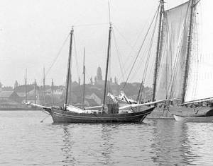
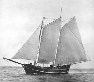
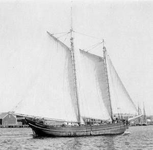
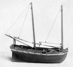
The colonial American shallop is the ancestor of many regional types of New England fishing craft found in Lane's paintings and drawings, including "New England Boats" (known as "boats" and discussed elsewhere), and later descendents, such as "Chebacco Boats," "Dogbodies," and "Pinkies."
These boats were very common work boat types on Cape Ann throughout the 1800s. They were primarily used for inshore coastal fishing, which included lobstering, gill-netting, fish-trapping, hand-lining, and the like. They were usually sailed by one or two men, sometimes with a boy, and could be rowed as well as sailed. An ordinary catch would include rock cod, flounder, fluke, dabs, or other small flat fish. The catch would be eaten fresh, or salted and stored for later consumption, or used as bait fish. Gill-netting would catch herring and alewives when spawning. Wooden lobster traps were marked with buoys much as they are today, and hauled over the low sides of the boat, emptied of lobsters and any by-catch, re-baited and thrown back.
CHEBACCO BOATS AND PINKIES
In the Chebacco Parish of the Ipswich Colony, a larger version of the colonial shallop evolved to a heavily built two-masted boat with either a sharp or square stern. This development included partial decking at bow and stern, the former as a cuddy which was fitted with crude bunks and a brick fireplace for cooking. Further development provided midship decking over a fish hold with standing rooms fore and aft for fishing. At this stage, low bulwarks replaced simple rails and in the double-enders were extended aft beyond the rudderhead to form a “pinched,” or “pink“ stern. Some time in the second half of the eighteenth century, boats with these characteristics became known as Chebacco Boats. The squarestern versions were called Dogbodies, for reasons now forgotten. (1)
Chebacco Boats became the vessels of choice for Cape Ann fishermen working coastal grounds for cod, mackerel, herring, and groundfish with hook and line or with nets. This did not prevent them from venturing further, particularly in pursuit of migrating schools of mackerel. The “Bashalore,” a corruption of the Bay of Chaleur in the Gulf of St. Lawrence, was a favorite destination for Cape Ann Fishermen who fished for mackerel in that region. (2)
Lane undoubtedly saw Chebacco Boats in the years prior to his move to Boston, but if he made drawings or paintings of them in that period, none have come to light. A small lithograph, titled “View of the Old Fort and Harbor 1837,” is attributed to him, but the vessels and wharf buildings are too crudely drawn to warrant this undocumented claim. (3) Lane did see and render accurately the Chebacco Boat’s successor the Pinky—which was larger and had a schooner rig (two masts, main sail, fore sail, jib, and main topmast staysail).
Schooners with pinksterns were recorded early in the 18th century later that there were models and graphic representations of hull form and rig (Ref. 4). By then, the pinky was very similar in hull form to Chebacco Boats, and some Chebacco Boats were converted to pinkies by giving them schooner rigs. A pinky in Lane’s The Old Fort and Ten Pound Island, Gloucester, 1850s (inv. 30) (misdated 1850s, more likely mid-1840s) is quite possibly an example of such a conversion.
Lane’s depictions of pinkies in Massachusetts waters are numerous and sometimes very informative. Examples in his views of Gloucester Harbor portray them at various angles, from broadside (see Gloucester Harbor from Rocky Neck, 1844 (inv. 14), The Old Fort and Ten Pound Island, Gloucester, 1850s (inv. 30), and View of the Town of Gloucester, Mass., 1836 (inv. 86)) to stern (see The Western Shore with Norman's Woe, 1862 (inv. 18), The Old Fort and Ten Pound Island, Gloucester, 1850s (inv. 30), and Gloucester Harbor, 1850s (inv. 391)), but few, if any, bow views. His portrayals of pinkies in Boston Harbor and vicinity are more in the foreground and more generous in detail. The earliest of these, from 1845, shows a pinky getting underway in a hurry as the yacht "Northern Light" bears down on her in The Yacht "Northern Light" in Boston Harbor, 1845 (inv. 268). A late harbor view (id ) offers a rare bow view.
Like the Chebacco Boat, the pinky was primarily a fishing vessel, doing much the same kind of fishing in coastal waters, but large enough to venture further offshore to work on the banks in the Gulf of Maine in pursuit of the cod. By the 1820s, pinkies reached their largest size: 50 to 60 feet on deck. Beyond that size called for a different deck arrangement and higher rails, so men could stand on deck and fish from the rails – an arrangement offered by the banks fishing schooner. (5)
What is perhaps Lane’s most detailed and narrative view of a pinky appears in Becalmed Off Halfway Rock, 1860 (inv. 344) and dominates the right foreground. Fitted-out for mackerel gillnetting, she has a dory and a wherry in tow, the latter with the net in the stern. The crew is relaxed, enjoying the evening calm as the vessel heads for port. The barrels on deck are filled with freshly caught mackerel, which will be sold as such when landed, most likely at Gloucester. This pinky was probably fishing on Stellwagen Bank or Cape Cod Bay, which were good fishing grounds for mackerel, and close enough to Gloucester to make trips in smaller vessels worthwhile. To judge from his paintings, Lane found only a few pinkies in the parts of the Maine Coast he explored. Only one drawing (Southwest Harbor, Mount Desert, 1852 (inv. 184)) and two widely published paintings (Entrance of Somes Sound, Mount Desert, Maine, 1855 (inv. 347) and Bar Island and Mt. Desert Mountains from Somes Settlement, 1850 (inv. 401)) illustrate this type, and then at a distance. What is apparent is that pinkies in southern Maine did not differ markedly from those on the Massachusetts coast. Had Lane ventured further Down East, he might have found modifications to the type that reflected Canadian influences. (6)
– Erik Ronnberg
References:
1. William A. Baker, Sloops & Shallops (Barre, MA: Barre Publishing Co., 1966), 82–91; and Howard I. Chapelle, The American Fishing Schooners, 1825–1935 (New York: W.W. Norton & Co., 1973), 25–27.
2. G. Brown Goode, The Fisheries and Fishery Industries of the United States, Section V, Vol. I (Washington, DC: Government Printing Office, 1884–87), 275, 287, 298–300, 419–21, 425–32, 459–63.
3. John J. Babson, History of the Town of Gloucester, Cape Ann (Procter Bros., 1860, reprint: Gloucester, MA: Peter Smith, 1972), see lithograph facing p. 474.
4. Goode, 275–77, 280, 294–96.
5. Chapelle, 36–37.
6. Ibid., 45–54.
Glass plate negative
3 x 4 in.
Cape Ann Museum Library & Archive
#10112
Also filed under: Gloucester Harbor, Inner / Harbor Cove »
Also filed under: Ship Models »
Also filed under: Ship Models »
Also filed under: Ship Models » // Small Craft – Wherries, and Dories »
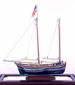
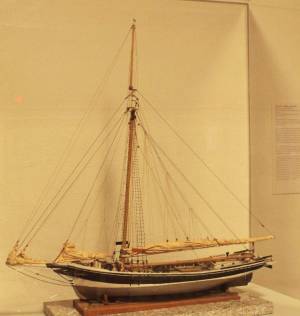
20" l. x 19" h. x 3 3/4" w. [not to scale]
Cape Ann Museum. Gift of Mr. J. Hollis Griffin, 1940 (891)
"Pinkys" were early nineteenth-century schooner-rigged derivations of Chebacco boats. This model is a good example of a traditional “sailor’s model,” or in this case, a sailmaker’s model, Mr. Nickerson having been a sailmaker.
Also filed under: Ship Models »

1860 In John J. Babson, History of the Town Gloucester (Gloucester, MA: Procter Brothers, 1860) Cape Ann Museum Library & Archives, Gloucester, Mass.
See p. 474.
View related catalogue entries (4) »
Also filed under: Babson History of the Town of Gloucester » // Fort (The) and Fort Point » // Gloucester Harbor, Inner / Harbor Cove » // Gloucester, Mass. - "Ten Pound Island Light » // Schooner (Coasting / Lumber / Topsail / Packet / Marsh Hay) » // Ten Pound Island »
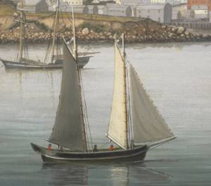
"Party boat" is a colloquial term for any kind of small craft adapted or used for taking guests (customarily for hire) on sightseeing trips or fishing for pleasure. (1) The term survives to this day on Cape Ann and other places for vessels engaged in the same activities. (2) In Lane's time, party boating was a calling of opportunity, and a fisherman's boat might be used in season - regularly or occasionally - to take "rusticators" fishing. Likewise, a boat used for its owner's own pleasure might be hired to take sightseers sailing for an afternoon. The latter use is seen in Lane's 1844 view of Gloucester Harbor from Rocky Neck (see the yawl-rigged sailboat in the foreground of Gloucester Harbor from Rocky Neck, 1844 (inv. 14)).
By the early 1850s, summer visitor activity, encouraged by the building of the Pavilion Hotel on Gloucester's waterfront, led to increased pleasure boating activity, if Lane's painting Gloucester Harbor, 1852 (inv. 38) of Pavilion Beach and Sidney Mason's hotel is any indication. (3) Lane's Gloucester Harbor scenes from this decade show a number of pleasure craft suitable for taking passengers for hire (see Fresh Water Cove from Dolliver's Neck, Gloucester, Early 1850s (inv. 45), Coming Ashore near Brace's Rock, Gloucester, Massachusetts, c.1860 (inv. 60), and View of Gloucester from "Brookbank," the Sawyer Homestead, c.1856 (inv. 95)). Small working craft suitable for this purpose are seen in The Old Fort and Ten Pound Island, Gloucester, 1850s (inv. 30), Gloucester Harbor, 1852 (inv. 38) (right foreground), View of Gloucester, 1859 (inv. 91) (foreground), and Watch House Point, 1860 (inv. 292) (right foreground). In View of Gloucester Harbor, 1848 (inv. 97), we see passengers boarding a small sloop-rigged boat hidden by the rocks at Duncan's Point (left middle ground).
In coastal waters south of Gloucester, a few of Lane's paintings offer pleasure craft as candidates for taking paying passengers. Phantom of Boston, c.1850s (inv. 574) depicts a cruising yawl "Phantom" of Boston, beached with hunting gear unloaded alongside while two of the crew await an approaching party in a rowing boat. The location is unidentified, but a possibility is the barrier beach around the marshes of Lynn, Massachusetts, which were once very popular hunting grounds for migrating waterfowl. A second candidate is a small sloop with a party of four on an evening sail off Halfway Rock in Becalmed Off Halfway Rock, 1860 (inv. 344) (far right).
Lane found similar uses of working watercraft in Maine, where the families of a small coastal community would travel by their workboats to a gathering place for a clambake or similar festive outing (see View of Indian Bar Cove, Brooksville, Maine, 1850 (inv. 61)). The artist became a "rusticator" himself when he, Joseph Stevens, and friends explored Mount Desert Island and vicinity in the "General Gates," a sloop-rigged Maine version of a New England Boat (View of Bar Island and Mount Desert Mountains, from the Bay in Front of Somes Settlement, 1850 (inv. 177) and Castine Harbor and Town, 1851 (inv. 272)).
When Lane traveled to New Bedford in 1856 to observe and sketch a regatta held by the New York Yacht Club, he observed and sketched it while on board an unknown vessel near the starting and finishing line, formed by the race committee boat "Emblem" and her yawl-boat.
Close by was a small party boat with observers on board, probably a fishing sloop, given its work-a-day looks. In the ensuing year, Lane painted four detailed views of this race, the party boat appearing in New York Yacht Club Regatta (1), 1856 (inv. 66) (right foreground); New York Yacht Club Regatta (2), 1856 (inv. 270) (right margin); New York Yacht Club Regatta (3), After 1856 (inv. 396) (center); and New York Yacht Club Regatta (4), 1857 (inv. 397) (left foreground). (4)
– Erik Ronnberg
References:
1. M. H. Parry and others, Aak to Zumbra: A Dictionary of the World's Watercraft (Newport News, VA: The Mariners' Museum, 2000), 436.
2. Ibid.
3. Proctor's Able Sheet (a Gloucester newspaper), January 1857: "Gloucester House reopened—refitted—boats always ready to take parties cruising or fishing..."
4. John Wilmerding, Fitz Henry Lane, 2nd ed. (Cape Ann, MA: Cape Ann Historical Association, 2005), 52–54. Lane's 1852 cruise in the Mount Desert region in the sloop "Superior" was reprinted as an appendix to Wilmerding's essay in Paintings by Fitz Hugh Lane (Washington, DC: National Gallery of Art, 1988), 125–26.
Oil on canvas
34 x 45 3/4 in.
Cape Ann Museum, Gloucester, Mass., Gift of Mrs. Jane Parker Stacy (Mrs. George O. Stacy),1948 (1289.1a)
Detail of party boat.
Also filed under: Gloucester Harbor, Inner / Harbor Cove »
Oil on canvas
22 x 36 in.
Cape Ann Museum, Gloucester, Mass., deposited by the Collection of Addison Gilbert Hospital, 1978 (DEP. 201)
Detail of party boat.
Also filed under: Ten Pound Island »
Newspaper
Ad in Gloucester Telegraph
FISHING AND SAILING PARTIES
"Persons desirous of enjoying a SAILING or FISHING EXCURSION, are informed that the subscriber will be in readiness with the Boat EUREKA, to attend to all who may favor him with their patronage. JOHN J. FERSON"
Also filed under: Gloucester Harbor – Use » // Newspaper / Journal Articles »
Newsprint
Ad for Gloucester House
Courtesy of the American Antiquarian Society, Worcester, Mass.
See p. 4, column 2.
Also filed under: Brick Houses / Gloucester House Hotel » // Newspaper / Journal Articles »
When inbound merchant ships approached their destination ports, they were required by law to pick up a pilot to guide the vessel safely into the harbor. Pilot schooners were stationed outside the ports to transfer one of their pilots to the incoming ship by means of a small rowing boat designed for this task, even in heavy seas. In the nineteenth and early twentieth century, this boat was called a canoe. In other ports, such as New York, they were of different design and called yawls. (1)
In hull form, the pilot canoe bore no resemblance to any Native American watercraft by that name. The term’s origin seems to be French, where a canot was a small, beamy, and very seaworthy rowing boat. A bilingual guide to French nautical terms and their English equivalents contains a sample dialogue between a shipmaster and a pilot wherein the term canot is used for the pilot’s boat. (2) Definitions and descriptions of the French canot as a ship's boat used for communication between vessels and between ship and shore support the French origin for the Boston pilots' term "canoe." (3) Pilot yawls, as built and used in New York, closely resembled Whitehall boats in design, though with variations in construction. (4)
– Erik Ronnberg
References:
1. Charles I. Lampee, “Memories of Cruises on Boston Pilot Boats of Long Ago,” Nautical Research Journal 10, no. 2: 44–58.
2. Eugène Pornain, Termes Nautiques (Sea Terms) Anglais Francais, 13th ed. (Paris: Augustin Challamel,1890), 181–83.
3. John Harland, Seamanship in the Age of Sail (London: Conway Maritime Press, 1984), 283–84; and Lecomte, Jules, Dictionnaire Pittoresque de Marine (Paris: 1835; Douarnenez: Editions de L'estran, 1982), see "canot."
4. Erik A.R. Ronnberg, Jr., “Boston Pilot Canoes Revisited,” Nautical Research Journal 39, no. 3: 166.
Oil on canvas
23 1/2 x 36 in. (59.7 x 91.4 cm)
Cape Ann Museum, Gloucester, Mass., Gift of the Estate of Marjory A. Johnson, 1988 (2612.00)
In this detail, the canoe can just be discerned conveying the pilot from the pilot boat to the clipper ship.
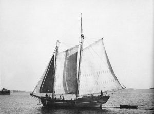
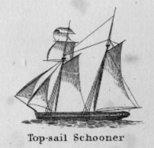
Schooners in Lane’s time were, with few exceptions, two-masted vessels carrying a fore-and-aft rig having one or two jibs, a fore staysail, gaff-rigged fore- and main sails, and often fore- and main topsails. One variant was the topsail schooner, which set a square topsail on the fore topmast. The hulls of both types were basically similar, their rigs having been chosen for sailing close to the wind. This was an advantage in the coastal trade, where entering confined ports required sailing into the wind and frequent tacking. The square topsail proved useful on longer coastwise voyages, the topsail providing a steadier motion in offshore swells, reducing wear and tear on canvas from the slatting of the fore-and-aft sails. (1)
Schooners of the types portrayed by Lane varied in size from 70 to 100 feet on deck. Their weight was never determined, and the term “tonnage” was a figure derived from a formula which assigned an approximation of hull volume for purposes of imposing duties (port taxes) on cargoes and other official levies. (2)
Crews of smaller schooners numbered three or four men. Larger schooners might carry four to six if a lengthy voyage was planned. The relative simplicity of the rig made sail handling much easier than on a square-rigged vessel. Schooner captains often owned shares in their vessels, but most schooners were majority-owned by land-based firms or by individuals who had the time and business connections to manage the tasks of acquiring and distributing the goods to be carried. (3)
Many schooners were informally “classified” by the nature of their work or the cargoes they carried, the terminology coined by their owners, agents, and crews—even sometimes by casual bystanders. In Lane’s lifetime, the following terms were commonly used for the schooner types he portrayed:
Coasting schooners: This is the most general term, applied to any merchant schooner carrying cargo from one coastal port to another along the United States coast (see Bar Island and Mt. Desert Mountains from Somes Settlement, 1850 (inv. 401), right foreground). (4)
Packet schooners: Like packet sloops, these vessels carried passengers and various higher-value goods to and from specific ports on regular schedules. They were generally better-maintained and finished than schooners carrying bulk cargoes (see The Old Fort and Ten Pound Island, Gloucester, 1850s (inv. 30), center; and Gloucester Inner Harbor, 1850 (inv. 240), stern view). (5)
Lumber schooners: Built for the most common specialized trade of Lane’s time, they were fitted with bow ports for loading lumber in their holds (see View of Southwest Harbor, Maine: Entrance to Somes Sound, 1852 (inv. 260)) and carried large deck loads as well (Stage Rocks and the Western Shore of Gloucester Outer Harbor, 1857 (inv. 8), right). Lumber schooners intended for long coastal trips were often rigged with square topsails on their fore masts (see Becalmed Off Halfway Rock, 1860 (inv. 344), left; ; and Lumber Schooner in a Gale, 1863 (inv. 552)). (6)
Schooners in other specialized trades. Some coasting schooners built for carrying varied cargoes would be used for, or converted to, special trades. This was true in the stone trade where stone schooners (like stone sloops) would be adapted for carrying stone from quarries to a coastal destination. A Lane depiction of a stone schooner is yet to be found. Marsh hay was a priority cargo for gundalows operating around salt marshes, and it is likely that some coasting schooners made a specialty of transporting this necessity for horses to urban ports which relied heavily on horses for transportation needs. Lane depicted at least two examples of hay schooners (see Gloucester Harbor, 1850s (inv. 391), left; and Coasting Schooner off Boon Island, c.1850 (inv. 564)), their decks neatly piled high with bales of hay, well secured with rope and tarpaulins.
– Erik Ronnberg
References:
1. Howard I. Chapelle, The History of American Sailing Ships (New York: W.W. Norton & Co., 1935), 258. While three-masted schooners were in use in Lane’s time, none have appeared in his surviving work; and Charles S. Morgan, “New England Coasting Schooners”, The American Neptune 23, no. 1 (DATE): 5–9, from an article which deals mostly with later and larger schooner types.
2. John Lyman, “Register Tonnage and its Measurement”, The American Neptune V, nos. 3–4 (DATE). American tonnage laws in force in Lane’s lifetime are discussed in no. 3, pp. 226–27 and no. 4, p. 322.
3. Ship Registers of the District of Gloucester, Massachusetts, 1789–1875 (Salem, MA: The Essex Institute, 1944). Vessels whose shipping or fishing voyages included visits to foreign ports were required to register with the Federal Customs agent at their home port. While the vessel’s trade or work was unrecorded, their owners and master were listed, in addition to registry dimensions and place where built. Records kept by the National Archives can be consulted for information on specific voyages and ports visited.
4. Howard I. Chapelle, The National Watercraft Collection (Washington, DC: Smithsonian Institution, 1960), 40, 42–43.
5. Ibid., 42–43, 73.
6. Ibid., 74–76.

In R. H. Dana, The Seaman's Friend, 13th ed. (Thomas Groom & Co. Publisher, 1873)
A topsail schooner has no tops at her foremast, and is fore-and-aft rigged at her mainmast. She differs from an hermaphrodite brig in that she is not properly square-rigged at her foremast, having no top, and carrying a fore-and-aft foresail instead of a square foresail and a spencer.

Detail views: marine railway and hauling cradle for vessel Wood rails, metal rollers, chain; wood cradle. Scale: ½" = 1' (1:24) Original diorama components made, 1892; replacements made, 1993. Cape Ann Museum, from Gloucester Chamber of Commerce, 1925 (2014.071)
A schooner is shown hauled out on a cradle which travels over racks of rollers on a wood and metal track.
Also filed under: Burnham Brothers Marine Railway » // Marine Railways »

c. 1900 Glass plate negative Collection of Erik Ronnberg
Also filed under: Lobstering »
"The Maine Register for the Year 1855, embracing State and County Officers, and an abstract of the law and resolves; together with a complete business directory of the state, and a variety of useful information."
Details about Maine's lumber trade in 1855, see pp. 250–52
Also filed under: Castine » // Lumber Industry »
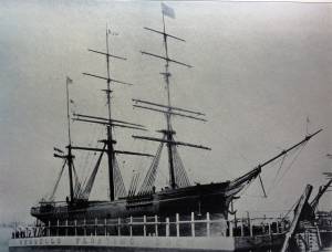
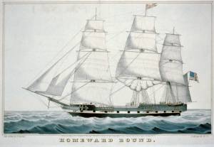
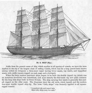
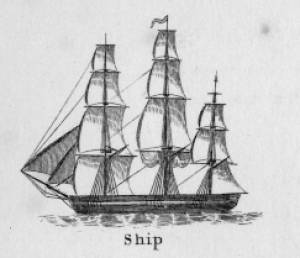
The term "ship," as used by nineteenth-century merchants and seamen, referred to a large three-masted sailing vessel which was square-rigged on all three masts. (1) In that same period, sailing warships of the largest classes were also called ships, or more formally, ships of the line, their size qualifying them to engage the enemy in a line of battle. (2) In the second half of the nineteenth century, as sailing vessels were replaced by engine-powered vessels, the term ship was applied to any large vessel, regardless of propulsion or use. (3)
Ships were often further defined by their specialized uses or modifications, clipper ships and packet ships being the most noted examples. Built for speed, clipper ships were employed in carrying high-value or perishable goods over long distances. (4) Lane painted formal portraits of clipper ships for their owners, as well as generic examples for his port paintings. (5)
Packet ships were designed for carrying capacity which required some sacrifice in speed while still being able to make scheduled passages within a reasonable time frame between regular destinations. In the packet trade with European ports, mail, passengers, and bulk cargos such as cotton, textiles, and farm produce made the eastward passages. Mail, passengers (usually in much larger numbers), and finished wares were the usual cargos for return trips. (6) Lane depicted these vessels in portraits for their owners, and in his port scenes of Boston and New York Harbors.
Ships in specific trades were often identified by their cargos: salt ships which brought salt to Gloucester for curing dried fish; tea clippers in the China Trade; coffee ships in the West Indies and South American trades, and cotton ships bringing cotton to mills in New England or to European ports. Some trades were identified by the special destination of a ship’s regular voyages; hence Gloucester vessels in the trade with Surinam were identified as Surinam ships (or barks, or brigs, depending on their rigs). In Lane’s Gloucester Harbor scenes, there are likely (though not identifiable) examples of Surinam ships, but only the ship "California" in his depiction of the Burnham marine railway in Gloucester (see Three Master on the Gloucester Railways, 1857 (inv. 29)) is so identified. (7)
– Erik Ronnberg
References:
1. R[ichard)] H[enry] Dana, Jr., The Seaman’s Friend, 13th ed. (Boston: Thomas Groom & Co., 1873), p. 121 and Plate IV with captions.
2. A Naval Encyclopaedia (Philadelphia: L. R. Hamersly & Co., 1884), 739, 741.
3. M.H. Parry, et al., Aak to Zumbra: A Dictionary of the World’s Watercraft (Newport News, VA: The Mariners’ Museum, 2000), 536.
4. Howard I. Chapelle, The History of American Sailing Ships (New York: W.W. Norton & Co., 1935), 281–87.
5. Ibid.
6. Howard I. Chapelle, The National Watercraft Collection (Washington, DC: Smithsonian Institution, 1960), 26–30.
7. Alfred Mansfield Brooks, Gloucester Recollected: A Familiar History (Gloucester, MA: Peter Smith, 1974), 67–69.
Photograph
From American Clipper Ships 1833–1858, by Octavius T. Howe and Frederick C. Matthews, vol. 1 (Salem, MA: Marine Research Society, 1926).
Photo caption reads: "'Golden State' 1363 tons, built at New York, in 1852. From a photograph showing her in dock at Quebec in 1884."
Also filed under: "Golden State" (Clipper Ship) »
_sm.jpg)

Oil on canvas
24 x 35 in.
Peabody Essex Museum, Salem, Mass.
Walters' painting depicts the "Nonantum" homeward bound for Boston from Liverpool in 1842. The paddle-steamer is one of the four Clyde-built Britannia-class vessels, of which one is visible crossing in the opposite direction.
View related catalogue entries (2) »
Also filed under: Packet Shipping » // Walters, Samuel »
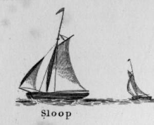
Sloops are one-masted sailing vessels which, in American examples, set fore-and-aft sails but usually no square sails. Thus, staysails, or jibs, are set from the fore stay(s) and a quadrilateral mainsail is set from the mast and spread by a gaff and a boom. The larger sloops would often set a triangular topsail over the main sail. (1)
The sloops depicted by Lane were used in various coastal trades, each with its own requirements, which dictated the sizes and details of their hulls and rigs. Most elegant were the packet sloops, which transported passengers, mail, and higher value goods between specific ports on regular schedules. They usually measured between sixty and seventy-five feet on deck, as dictated by anticipated shipping volume. Finely finished, they usually had stern galleries—a row of windows across the transom with ornamental moldings—and varied color schemes. Examples of packet sloops are in Gloucester Harbor from Rocky Neck, 1844 (inv. 14) (center, middle ground) and Study of Ships, 1851 (inv. 141) (foreground), both of which probably made trips between Gloucester and Boston, or Gloucester and Newburyport. (2)
Another specialized sloop of similar size was the stone sloop, used to ship granite blocks from stone-loading piers around Cape Ann to other ports. They were similar in rig to packet sloops, but of heavier construction with greater hold capacity and absence of decoration. Their stout appearance was augmented by simple color schemes, or even tarred topsides, reflecting the wear and strain imposed by their heavy cargos. Lane depicted these vessels in his painting of Fresh Water Cove from Dolliver's Neck, Gloucester, Early 1850s (inv. 45), with a sloop (at left) preparing to load at wharf-side, and another (at right) sailing out with a cargo. (3)
Sloops of the more work-a-day sort are the most commonly seen examples in Lane’s paintings, most of them appearing in his views of Boston Harbor. Usually deep-loaded and looking weather-worn, they contrast sharply with the packet- and clipper ships which dominate the scene. Sloops of this type are rarely seen in Lane’s paintings of Gloucester Harbor and the Maine coast, although they were certainly needed for short-distance transportation (see Bear Island, Northeast Harbor, 1855 (inv. 24), View of Camden Mountains from Penobscot Bay, c.1852 (inv. 207), Sunrise on the Maine Coast, Mount Desert Island, 1856 (inv. 295)). For coastal Maine, lack of railroads for heavier freight and greater distances between ports made the use of schooners with larger carrying capacity a greater necessity. (4)
In Lane’s views of New York Harbor, a regional sloop variant, the Hudson River Sloop, appears in New York Harbor, c.1855 (inv. 46) (bow view, left) and A Calm Sea, c.1860 (inv. 6) (stern view, right). This type had become prominent in the Hudson River packet trade between New York City, Albany, and beyond to points north and west as far as the eastern terminus of the Erie Canal. Large vessels for their rigs, they were well-finished and well-kept, reflecting pride of ownership and rivalry among their owners and crews. (5)
– Erik Ronnberg
References:
1. A Naval Encyclopaedia (Philadelphia: L.R. Hamersly & Co., 1884. Reprint: Detroit, MI: Gale Research Company, 1971), 59. See first definition of "sloop" and definition of "sloop-rigged."
2. Robert Greenhalgh Albion, William A. Baker, and Benjamin Woods Labaree, New England and the Sea (Mystic, CT: Mystic Seaport Museum, 1972; reprinted in 1994), 127–28.
3. Howard I. Chapelle, The History of American Sailing Ships (New York: W.W. Norton & Co., 1935), 300–02.
4. Ibid., 300.
5. Ibid., 298–300.
A Naval Encyclopaedia:
Dictionary of nautical words and phrases
Special Articles on Naval Art and Science
Philadelphia: L.R. Hamersly & Co.
'Mudian, "Mugian, or Bermudian. A boat special to the Bermuda islands, usually decked, with the exception of a hatch; from 2 to 20 tons burden; it is short, of good beam, and great draft of water abaft, the stem and keel forming a curved line. It carries an immense quantity of ballast. Besides a long main- and short jib-boom, it has a long, taperking, raking mast, stepped just over the forefoot, generally unsupported by shrouds or stays; on it a jib-headed mainsail is hoisted to a height of twice, and sometimes three times, the length of the keel. This sail is triangular, stretched at its foot by a long boom. The only other sail is a small foresail or jib. They claim to be the fastest craft in the world for working to windward in smooth water, it being recorded of one that she made five miles dead to windward in the hour during a race; and though they may be laid over until they fill with water, they will not capsize.
St. George's Historical Society
Detail of painting of St. George's Harbour, Bermuda, during US Civil War, with a Confederate blockade runner anchored in the foreground.
Also filed under: Puerto Rico »
Wood, metal, cordage, cloth, paint.
Scale: ¼ in. = 1ft. (1:48)
Cape Ann Museum. Gift of Roland and Martta Blanchet (1997.17.3)
Although built in 1890 and larger than the stone sloops of Lane’s time, the "Albert Baldwin’s" hull form, rig, and loading boom are very similar to those of the 1840s and 1850s.
Also filed under: Granite Quarrying / Shipping » // Ship Models »
The ensign of the United States refers to the flag of the United States when used as a maritime flag to indentify nationality. As required on entering port, a vessel would fly her own ensign at the stern, but a conventional token of respect to the host country would be to fly the flag of the host country (the United States in Boston Harbor, for example) at the foremast. See The "Britannia" Entering Boston Harbor, 1848 (inv. 49) for an example of a ship doing this. The American ensign often had the stars in the canton arranged in a circle with one large star in the center; an alternative on merchant ensigns was star-shaped constellation. In times of distress a ship would fly the ensign upside down, as can be seen in Wreck of the Roma, 1846 (inv. 250).
The use of flags on vessels is different from the use of flags on land. The importance and history of the flagpole in Fresh Water Cove in Gloucester is still being studied.
The modern meaning of the flag was forged in December 1860, when Major Robert Anderson moved the U.S. garrison from Fort Moultrie to Fort Sumter in Charleston Harbor. Adam Goodheart argues this was the opening move of the American Civil War, and the flag was used throughout northern states to symbolize American nationalism and rejection of secessionism.
Before that day, the flag had served mostly as a military ensign or a convenient marking of American territory, flown from forts, embassies, and ships, and displayed on special occasions like American Independence day. But in the weeks after Major Anderson's surprising stand, it became something different. Suddenly the Stars and Stripes flew—as it does today, and especially as it did after the September 11 attacks in 2001—from houses, from storefronts, from churches; above the village greens and college quads. For the first time American flags were mass-produced rather than individually stitched and even so, manufacturers could not keep up with demand. As the long winter of 1861 turned into spring, that old flag meant something new. The abstraction of the Union cause was transfigured into a physical thing: strips of cloth that millions of people would fight for, and many thousands die for.
– Adam Goodheart, Prologue of 1861: The Civil War Awakening (2011).
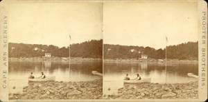
1860s Stereograph card Cape Ann Museum Library & Archive
A view of a Cove on the western side of Gloucester Harbor, with the landing at Brookbank. Houses are seen in the woods back. A boat with two men is in the foreground.
Also filed under: Brookbank » // Fresh Water Cove » // Historic Photographs »
Courtesy American Antiquarian Society, Worcester, Mass. (CL.F9116.011.1854 CL.F9116.011.1854)
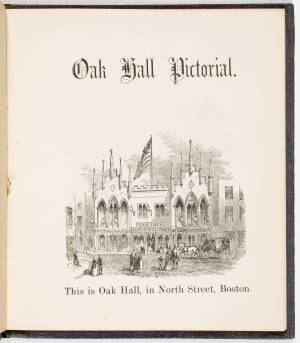
Also filed under: Oak Hall »
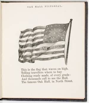
Courtesy American Antiquarian Society, Worcester, Mass. (CL.F9116.011.1854)
Also filed under: Oak Hall »
The Ten Pound Island light was built on a three-and-a-half acre island at the eastern end of Gloucester Harbor. Built as a conical stone tower, the original 20-foot-tall Ten Pound Island Light was first lit in October, 1821 after the Commonwealth of Massachusetts and the Town of Gloucester ceded 1.7 acres to the U.S. Government for the construction of an inner harbor lighthouse to help mariners navigate the harbor. Ten Pound Island light was a popular subject with artists, including Winslow Homer, who boarded with the lighthouse keeper at Ten Pound Island in the summer of 1880. It is frequently featured in Lane's paintings of Gloucester Harbor.
This information has been shared with the Lane project by Jeremy D'Entremont. More information can be found at his website, www.newenglandlighthouses.net or in The Lighthouse Handbook New England. This information has also been summarized from Paul St. Germain's book, Lighthouses and Lifesaving Stations on Cape Ann.

Colored lithograph
Cape Ann Museum Library and Archive
Also filed under: Ten Pound Island »
Photograph
From The Illustrated Coast Pilot with Sailing Directions. The Coast of New England from New York to Eastport, Maine including Bays and Harbors, N. L. Stebbins, 1891.
Also filed under: Ten Pound Island »

