An online project under the direction of the CAPE ANN MUSEUM
Catalogue Entry
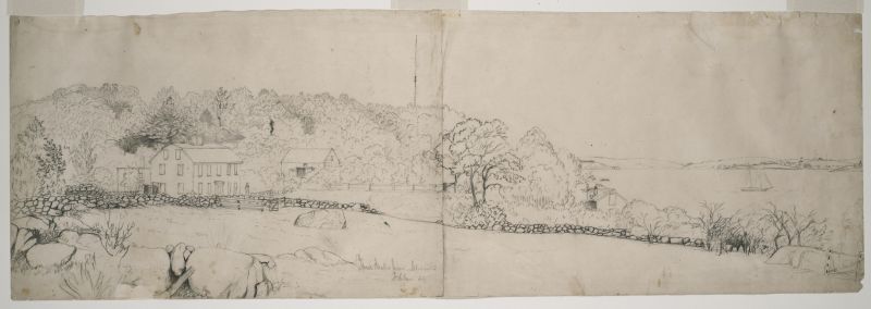
This drawing of Samuel Sawyer's estate, Brookbank, was the sketch for the painting sold to Sawyer in 1860 (Brookbank, The Sawyer Homestead, 1860 (inv. 216)), indicating that perhaps 1860 is the correct date for the drawing. Brookbank was renovated several times over the years, and the house and barn in the drawing show the way they appeared before the renovations. Lane has paid particular attention to the rock wall and details of the trees and vegetation.
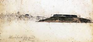
In the background can be seen the flagpole above Fresh Water Cove, Fort Point, and the Fort and, off to the right of the composition, Ten Pound Island and the lighthouse.
- Subject Types
: - Landscape Types
: - Cape Ann Locales
: - Objects
: - Building Types
: - Barn »
Historical Materials
Samuel Sawyer Papers
Cape Ann Museum Library & Archives
Archive Collection
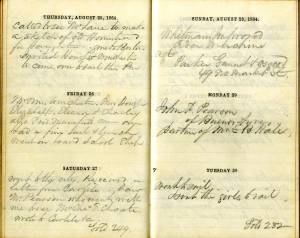
"August 25. Called to see Mr. Lane to make a sketch of old Homestead for Haughtons."
Filed under: Brookbank » // Diaries / Ledgers / Etc. » // Haughton, James » // Sawyer, Samuel »
Brookbank was an early eighteenth-century white gambrel-roofed house on Fresh Water Cove which was owned and occupied by Samuel Sawyer and his ancestors. It is possible to trace apparent renovations to the house through Lane's pictures; at first it is depicted as a white house without dormers and a simple brown barn Fresh Water Cove, Gloucester, c.1864 (inv. 112); then dormers appear on the house and the barn is white with a cupola Fresh Water Cove, etc., from Dolliver's Neck, 1850s (inv. 113). In Gloucester from Brookbank, 1848 (inv. 42) a cobb wharf (log cabin-like structure) and boardwalk are visible. By Fresh Water Cove from Dolliver's Neck, Gloucester, Early 1850s (inv. 45) the house seems to have additions.
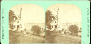
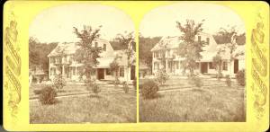
Stereograph card Cape Ann Museum Library & Archive
Stereo view of Brookbank guest house or boathouse.
Also filed under: Historic Photographs »
Published by Frank Rowell Cape Ann Museum Library & Archive
Stereograph card
Also filed under: Historic Photographs »
n.d. Stereographic card Cape Ann Museum Library & Archive
Penciled on reverse: "Mansion House, Brook Bank [sic], Sam'l Sawyer now Hammond, Freshwater Cove"
Also filed under: Historic Photographs » // Sawyer, Samuel »

44 x 34 in.
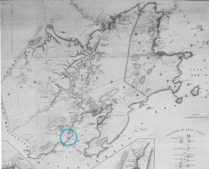
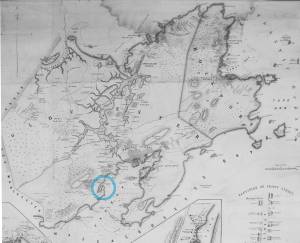
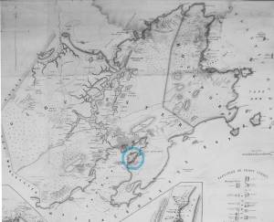
Henry Francis Walling, Map of the Towns of Gloucester and Rockport, Essex Co. Massachusetts. Philadelphia, A. Kollner, 1851
Cape Ann Museum Library & Archive
"Map of the Towns of Gloucester and Rockport, Massachusetts. H.F. Walling, Civil Engineer. John Hanson, Publisher. 1851. Population of Gloucester in 1850: 7,805. Population of Rockport in 1850: 3,213."
Also filed under: Annisquam River » // Dolliver's Neck » // Fresh Water Cove » // Gloucester Harbor, Outer » // Maps » // Norman's Woe » // Stage Rocks / Stage Fort / Stage Head » // Steepbank » // West Gloucester – Little River » // Western Shore »
Samuel Sawyer Papers
Cape Ann Museum Library & Archives
Archive Collection
"August 25. Called to see Mr. Lane to make a sketch of old Homestead for Haughtons."
Also filed under: Diaries / Ledgers / Etc. » // Haughton, James » // Sawyer, Samuel »
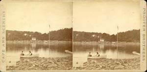
1860s Stereograph card Cape Ann Museum Library & Archive
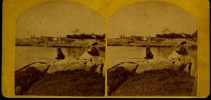
A view of a Cove on the western side of Gloucester Harbor, with the landing at Brookbank. Houses are seen in the woods back. A boat with two men is in the foreground.
Also filed under: American ensign / flag » // Fresh Water Cove » // Historic Photographs »
Stereograph card
Cape Ann Museum Library & Archive
Also filed under: Fresh Water Cove »
Lane did a remarkable series of paintings from Brookbank, the Sawyer homestead, which overlooks Fresh Water Cove. They show Dolliver’s Neck and how it protects the cove from the harbor. It is also visible in Dolliver's Neck and the Western Shore from Field Beach, 1857 (inv. 3), though somewhat disguised by the rest of the western shore in that view. He did a drawing and painting from Dolliver’s Neck looking west in Fresh Water Cove from Dolliver's Neck, Gloucester, Early 1850s (inv. 45).
Dolliver’s Neck is a small arm of land pointing north off the western shore of the Gloucester’s Outer Harbor. It is the cradling arm that creates Fresh Water Cove, a small cove where Samuel de Champlain found fresh water on his first visit to Gloucester Harbor in 1606. It was named for Samuel Dolliver who came from Marblehead in 1652 and bought a farm there.
In Lane’s time there were a few fishing shacks visible in some of his paintings where onshore fishermen could put their boats in from the pebble beach and salt marsh and be out in the center of the harbor without the long row or sail from the Inner Harbor. Fresh Water Cove itself is not deep enough at low tide for larger vessels to moor there so it has retained its small scale and intimate feel down through the years.
In 1900 a Coast Guard lifesaving station was built and manned on Dolliver’s Neck and many lives were saved along that rocky and treacherous coast between Gloucester and Magnolia.
Newsprint
From bound volume owned by publisher Francis Procter
Collection of Fred and Stephanie Buck
"We visited the studio of Mr. Fitz H. Lane a few days since, and were much pleased in examining some fine paintings from the pencil of this talented artist. Among the collection was a view of Long Beach, in this town, with which we were particularly interested.
The scene is taken immediately after a storm. The waves with their snowy crests are rolling in upon the beach, breaking against the sides of a vessel which has been driven ashore. In the background is seen the residence of Mr. Fessenden, and the surrounding scenery; on the right are visible the high headlands near the residence of Mr. Geo. Hovey, while stretching far away in the distance may be seen Fresh Water Cove, Dolliver's Neck, and the Old Pine Tree, the whole forming a beautiful picture and true to Nature.
Several other paintings were in process of completion, one a beautiful sunset scene, which was really beautiful to gaze upon; also a view of a gale at sea, with a gallant ship plunging madly through the waves, forming a striking contrast to the mild placid scene of the picture at its side.
Mr. Lane's paintings are true to nature, and in viewing them one can but admire the skill and genius of this talented artist, We advise all lovers of the art, who wish to spend an hour pleasantly, to visit the studio of Mr. Lane on Locust St. We can assure them that they will come away highly gratified, and have an earnest desire to call again." (1)
(1) See p. 2, column 3, Courtesy of the American Antiquarian Society
Also filed under: Chronology » // Fessenden, C. B. » // Fresh Water Cove » // Lone Pine » // Newspaper / Journal Articles » // Steepbank » // Studio Descriptions »
44 x 34 in.
Henry Francis Walling, Map of the Towns of Gloucester and Rockport, Essex Co. Massachusetts. Philadelphia, A. Kollner, 1851
Cape Ann Museum Library & Archive
"Map of the Towns of Gloucester and Rockport, Massachusetts. H.F. Walling, Civil Engineer. John Hanson, Publisher. 1851. Population of Gloucester in 1850: 7,805. Population of Rockport in 1850: 3,213."
Also filed under: Annisquam River » // Brookbank » // Fresh Water Cove » // Gloucester Harbor, Outer » // Maps » // Norman's Woe » // Stage Rocks / Stage Fort / Stage Head » // Steepbank » // West Gloucester – Little River » // Western Shore »

Engraving of 1819 survey taken from American Coast Pilot 14th edition
9 1/2 x 8 in.
Cape Ann Museum Library & Archive
D32 FF5
Also filed under: Eastern Point » // Maps » // Norman's Woe » // Ten Pound Island »
Newspaper
"Mr. Lane has just completed a third picture of the Western Shore of Gloucester Harbor, including the distance from 'Norman's Woe Rock' to 'Half Moon Beach.' It was painted for Mr. William E. Coffin of Boston, and will be on exhibition at the artist's rooms for only a few days; we advise all our readers who admire works of art, and would see one of the best pictures Mr. Lane has ever executed..."
"...solitary pine, so many years a familiar object and landmark to the fisherman."

c.1860 Stereograph card Cape Ann Museum Library & Archive
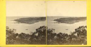
Taken from Steepbank, on the western side of Gloucester Harbor, and showing a small boat at anchor in the cove, then the Neck, and the sea beyond.
Also filed under: Fresh Water Cove » // Historic Photographs » // Lone Pine » // Steepbank »
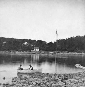
1860s Stereograph card Cape Ann Museum Library & Archive
"Cape Ann Scenery, John S. E. Rogers, Low's Block. #54 Dolliver's Neck. Taken from Steepbank, on the western side of Gloucester Harbor, and showing a small boat at anchor in the cove, then the Neck and the sea beyond."
Also filed under: Historic Photographs »
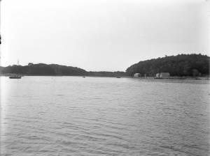
4 x 5 in.
Cape Ann Museum Library & Archive
Freshwater Cove and Dolliver's Neck from the water off Stage Fort.
Also filed under: Fresh Water Cove »
The owner of this flagpole has not been determined, but it is an interesting landmark in Lane's paintings. Often it appears in his drawings and not in his paintings, and Western Shore of Gloucester Outer Harbor, 1857 (inv. 107) contains the only image of a flag actually flying from the pole.
Through the years, this point and its fortifications had many names: Watch House Point, the Old Battery, Fort Defiance, Fort Head, and now just "The Fort." In 1793, Fort Defiance was turned over to the young United States government and was allowed to deteriorate. During the War of 1812 it was described as being "in ruins," and any remaining buildings burned in 1833. It was resuscitated in the Civil War and two batteries of guns were installed. The City of Gloucester did not regain ownership of the land until 1925.
The first fortifications on this point, guarding the entrance to the Inner Harbor, were put up in the 1740s, when fear of attack from the French led to the construction of a battery armed with twelve-pounder guns. Greater breastworks were thrown up in 1775, after Capt. Lindsay and his sloop-of-war the "Falcon" attacked the unprepared town. They were small and housed only a few cannon and local soldiers. Several other fortifications were at various times erected around the harbor: Fort Conant at what is now Stage Fort Park, another on Duncan's Point (near site of Lane's house) and the Civil War fort on Eastern Point. None of these preparations was ever called upon to actually defend the town.
Lane during his lifetime created a long series of images of the point and the condition of its fortifications. In 1832 there were still buildings standing, and the point had not yet been used for major wharves and warehouses. By the time of his painting Gloucester Harbor, 1852 (inv. 38), one can see that the earthwork foundation, but no superstructures, survived.
– Sarah Dunlap


1860 In John J. Babson, History of the Town Gloucester (Gloucester, MA: Procter Brothers, 1860) Cape Ann Museum Library & Archives, Gloucester, Mass.
See p. 474.
View related catalogue entries (4) »
Also filed under: Babson History of the Town of Gloucester » // Chebacco Boat / Dogbody / Pinky » // Gloucester Harbor, Inner / Harbor Cove » // Gloucester, Mass. - "Ten Pound Island Light » // Schooner (Coasting / Lumber / Topsail / Packet / Marsh Hay) » // Ten Pound Island »
Newsprint
Gloucester Telegraph
About picture of Old Fort hanging in the Gloucester Bank: "This picture is chiefly of interest on account of its preserving so accurately the features of a view so familiar to many of our citizens and which can never exist in reality."
Also filed under: Chronology » // Gloucester Bank » // Gloucester, Mass. – Gloucester Bank » // Newspaper / Journal Articles »

24 x 38 in.
Gloucester City Archives
"Drawn on a scale of one hundred feet to an inch. By John Mason 1834–45 from Actual Survey showing every Lott and building then standing on them giving the actual size of the buildings and width of the streets from the Canal to the head of the Harbour & part of Eastern point as farr as Smith's Cove and the Shore of the same with all the wharfs then in use. Gloucester Harbor 1834–35."
This map is especially useful in showing the Fort.
Also filed under: Flake Yard » // Maps » // Mason, John » // Pavilion (Publick) Beach » // Town / Public Landings »

44 x 34 in.
John Hanson, Publisher
Cape Ann Museum Library & Archive
"Map of the Towns of Gloucester and Rockport, Massachusetts. H.F. Walling, Civil Engineer. John Hanson, Publisher. 1851. Population of Gloucester in 1850 7,805. Population of Rockport in 1850 3,213."
Also filed under: Low (Frederick G.) wharves » // Maps » // Rogers's (George H.) wharves » // Town / Public Landings » // Waterfront, Gloucester » // Windmill »
Newsprint
Cape Ann Advertiser
Cape Ann Museum Library & Archive
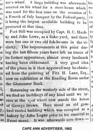
"Fort Hill was occupied by Capt. H. C. Mackay and John Lowe, as a flake-yard, and there were but one or two old fish-houses in the vicinity. The improvements at this point during the last fifteen years have left no traces of its former appearance, almost every landmark having been obliterated. A very good idea of the place as it then appeared may be obtained from the painting of Fitz H. Lane, Esq., now on exhibition at the Reading Room under the Gloucester Bank."
Also filed under: Gloucester Bank » // Newspaper / Journal Articles »
Newspaper
Gloucester Telegraph
"By the will of the late Fitz H. Lane, Esq., his handsome painting of the Old Fort, Ten Pound Island, etc., now on exhibition at the rooms of the Gloucester Maritime Insurance Co., was given to the town... It will occupy its present position until the town has a suitable place to receive it."
Also filed under: Funeral & Burial » // Gloucester, Mass. – Marine Insurance Company » // Newspaper / Journal Articles » // Ten Pound Island »
Newsprint
Gloucester Telegraph
At the dedication of the Town House, speaker, "read the following letter:
To the Selectmen of Gloucester: / Gents: The will of our late Townsman, Fitz. H. Lane, contains this provision: / I give to the inhabitants of the Town of Gloucester, the picture of the Old Fort, to be kept as a memento[sic] of one of the localities of olden time; the said picture now hanging in the Reading Room under the Gloucester Bank, and to be there kept until the Town of Gloucester shall furnish a suitable and safe place to hang it. / The original sketch was taken twenty-five years ago, but the boats and vessels introduced are those of a quarter of a century earlier still. The painting was executed in 1859, six years before his decease."
Also filed under: Documents / Objects » // Newspaper / Journal Articles » // Town House »

Stereograph card
Cape Ann Museum Library & Archive
View from top of Unitarian Church on Middle Street looking southeast, showing the Fort and Ten Pound Island. Tappan Block and Main Street buildings between Center and Hancock in foreground.
Also filed under: Ten Pound Island » // Unitarian Church / First Parish Church (Middle Street) »

1876 Photograph Cape Ann Museum Library & Archive
Ignatius Weber's windmill (now defunct) is shown.
Also filed under: Flake Yard » // Gloucester Harbor, Inner / Harbor Cove » // Historic Photographs » // Rogers's (George H.) wharves » // Schooner (Fishing) » // Waterfront, Gloucester » // Windmill »
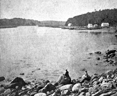
Fresh Water Cove is located on the west side of Gloucester’s Outer Harbor. It is protected from the harbor waters and the south-easterly seas by the arm of Dolliver’s Neck reaching north from the western shore. It’s a small, very still cove, only a few hundred yards from its mouth to the innermost shore.
The cove was visited by Samuel de Champlain in 1606. He was the first known European to enter Gloucester Harbor, which he named Le Beauport. He named Fresh Water Cove for the fresh water springs he found there, one a bit up from the shore, the other flowing below the high tide line and only accessible at half tide.
The cove, while very well protected from the weather, is small and very shallow at low tide and was never suitable for any large vessels, though there were fishing shacks along the shores edge and small boats were easily pulled up on the sand and salt marsh in its inner recesses. There was a wharf built in the early 1800s to service a granite quarry just up the hill from the cove, which could apparently handle larger vessels at high tide.
In Lane’s time, the most significant landmark from the cove was Brookbank, the Sawyer homestead where Samuel E. Sawyer was born in 1818. Sawyer made a fortune in Boston and returned to Brookbank every summer for fifty years. He became one of Gloucester’s first philanthropists. Lane did a series of paintings from the fields in front of Brookbank looking to the east from the house over Fresh Water Cove, the arm of Dolliver’s Neck and the harbor beyond. He also painted the opposite view in Fresh Water Cove from Dolliver's Neck, Gloucester, Early 1850s (inv. 45) looking west from Dolliver’s Neck over the cove to the Sawyer homestead and surrounding shoreline. Each of these paintings captures the perfect serenity of a high summer day in this secluded cove just off the busy harbor.
Stereograph card
Cape Ann Museum Library & Archive
Also filed under: Brookbank »
44 x 34 in.
Henry Francis Walling, Map of the Towns of Gloucester and Rockport, Essex Co. Massachusetts. Philadelphia, A. Kollner, 1851
Cape Ann Museum Library & Archive
"Map of the Towns of Gloucester and Rockport, Massachusetts. H.F. Walling, Civil Engineer. John Hanson, Publisher. 1851. Population of Gloucester in 1850: 7,805. Population of Rockport in 1850: 3,213."
Also filed under: Annisquam River » // Brookbank » // Dolliver's Neck » // Gloucester Harbor, Outer » // Maps » // Norman's Woe » // Stage Rocks / Stage Fort / Stage Head » // Steepbank » // West Gloucester – Little River » // Western Shore »
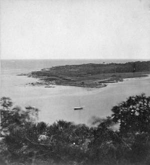
c.1860 Stereograph card Cape Ann Museum Library & Archive
Taken from Steepbank, on the western side of Gloucester Harbor, and showing a small boat at anchor in the cove, then the Neck, and the sea beyond.
Also filed under: Dolliver's Neck » // Historic Photographs » // Lone Pine » // Steepbank »
Newspaper
"Mr. Lane has just completed a third picture of the Western Shore of Gloucester Harbor, including the distance from 'Norman's Woe Rock' to 'Half Moon Beach.' It was painted for Mr. William E. Coffin of Boston, and will be on exhibition at the artist's rooms for only a few days; we advise all our readers who admire works of art, and would see one of the best pictures Mr. Lane has ever executed..."
"...solitary pine, so many years a familiar object and landmark to the fisherman."
Newsprint
From bound volume owned by publisher Francis Procter
Collection of Fred and Stephanie Buck
"We visited the studio of Mr. Fitz H. Lane a few days since, and were much pleased in examining some fine paintings from the pencil of this talented artist. Among the collection was a view of Long Beach, in this town, with which we were particularly interested.
The scene is taken immediately after a storm. The waves with their snowy crests are rolling in upon the beach, breaking against the sides of a vessel which has been driven ashore. In the background is seen the residence of Mr. Fessenden, and the surrounding scenery; on the right are visible the high headlands near the residence of Mr. Geo. Hovey, while stretching far away in the distance may be seen Fresh Water Cove, Dolliver's Neck, and the Old Pine Tree, the whole forming a beautiful picture and true to Nature.
Several other paintings were in process of completion, one a beautiful sunset scene, which was really beautiful to gaze upon; also a view of a gale at sea, with a gallant ship plunging madly through the waves, forming a striking contrast to the mild placid scene of the picture at its side.
Mr. Lane's paintings are true to nature, and in viewing them one can but admire the skill and genius of this talented artist, We advise all lovers of the art, who wish to spend an hour pleasantly, to visit the studio of Mr. Lane on Locust St. We can assure them that they will come away highly gratified, and have an earnest desire to call again." (1)
(1) See p. 2, column 3, Courtesy of the American Antiquarian Society
Also filed under: Chronology » // Dolliver's Neck » // Fessenden, C. B. » // Lone Pine » // Newspaper / Journal Articles » // Steepbank » // Studio Descriptions »
1860s Stereograph card Cape Ann Museum Library & Archive
A view of a Cove on the western side of Gloucester Harbor, with the landing at Brookbank. Houses are seen in the woods back. A boat with two men is in the foreground.
Also filed under: American ensign / flag » // Brookbank » // Historic Photographs »
4 x 5 in.
Cape Ann Museum Library & Archive
Freshwater Cove and Dolliver's Neck from the water off Stage Fort.
Also filed under: Dolliver's Neck »
Rocky Neck lies on the eastern side of Gloucester’s Inner Harbor and along with Ten Pound Island provides a vital block to the southerly and westerly seas running down the Outer Harbor. Called Peter Mud’s Neck in the late 1600s, it was an island at high tide until the 1830s, reachable only by walking over the sand bar connecting it to the mainland at low tide. When the stone causeway was put in in the 1830s it not only made the Rocky Neck a functional neighborhood of East Gloucester, it secured the southwest end of Smith’s Cove against swell from the Outer Harbor and made the cove a tight and secure anchorage.
In Lane’s time it was primarily sheep pasture with a small population living on the fringes. In 1859 a marine railway was built at the end of the neck which is still in operation. As a result of Gloucester’s burgeoning fish trade, wharves and fish businesses quickly sprang up along the shore of the newly secure Smith’s Cove. In 1863 another landmark Gloucester business, the marine antifouling copper paint manufactory of Tarr and Wonson was built on the western tip. The Hopper-esque dark red building still stands and guards the entrance to the Inner Harbor directly across from Fort Point.
Lane drew the view for his second and third Gloucester lithographs from Rocky Neck looking across to the Inner Harbor to the town. He also did a major painting Gloucester Harbor from Rocky Neck, 1844 (inv. 14) which shows the sheep, shepherd and dog on the rocky pasture in the foreground with the busy harbor and town unfolding before them.
In the second half of the nineteenth century, Rocky Neck became an active waterfront neighborhood with a row of grand houses on its spine overlooking the harbor and town. Edward Hopper painted one of the more spectacular Beaux Arts houses on that ridge, the afternoon light catching its extraordinary trim and mansard roof, still beautifully preserved today.
Rocky Neck is perhaps best known today as Gloucester’s, and arguably America’s, most famous art colony. Beginning in the 1880’s and extending through the 1970’s, multiple generations of artists, including Homer, Duveneck, Hopper, Sloan, Twachtman and many others, representing every artistic style, have summered and worked, socialized and relaxed in the quaint and once ramshackle confines of the Neck.
c.1870 Stereograph card Cape Ann Museum Library & Archive
Also filed under: Historic Photographs »

c.1870 Stereograph card Procter Brothers, Publisher Cape Ann Museum Library & Archive
"Gloucester Harbor from Rocky Neck, Looking Southwest. This gives a portion of the Harbor lying between Ten Pound Island and Eastern Point. At the time of taking this picture the wind was from the northeast, and a large fleet of fishing and other vessels were in the harbor. In the range of the picture about one hundred vessels were at anchor. In the small Cove in the foreground quite a number of dories are moored. Eastern Point appears on the left in the background."
Southeast Harbor was known for being a safe harbor.
Also filed under: Gloucester Harbor, Outer » // Historic Photographs » // Schooner (Fishing) » // Small Craft – Wherries, and Dories »
Newspaper clipping in "Authors and Artists "scrapbook
p.42
Cape Ann Museum Library & Archive
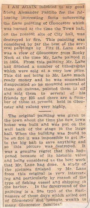
This painting was considered by far the best of the several paintings by Fitz H. Lane and was a view of Gloucester from Rocky Neck at the time Mr. Lane painted it in 1856. From this painting Mr. Lane had finished a number of lithographs which were sold at a very low price. This did not bring to Mr. Lane much ready money and he was somewhat disappointed so he mounted several of these on canvas, painted them in oil and sold them to several of his friends for $25 and there are a number of these at present held in Gloucester and valued very highly.
The original painting was given to the town about the time the new town house was built and was put on the wall back of the stage in the large hall. When the building was found to be on fire it was impossible to get into the big hall to save anything and so this picture was destroyed. It was a genuine regret that this happened because of its historic value and being considered as the best work that Mr. Lane had done. A study of the pictures finished by Mr. Lane from this original is very interesting and particularly by reason of the type of fishing vessel and shipping in the harbor. In the foreground of the painting is a fine type of the Surinamers of those days which sailed out of Gloucester and brought wealth to many Gloucester families.
The ensign of the United States refers to the flag of the United States when used as a maritime flag to indentify nationality. As required on entering port, a vessel would fly her own ensign at the stern, but a conventional token of respect to the host country would be to fly the flag of the host country (the United States in Boston Harbor, for example) at the foremast. See The "Britannia" Entering Boston Harbor, 1848 (inv. 49) for an example of a ship doing this. The American ensign often had the stars in the canton arranged in a circle with one large star in the center; an alternative on merchant ensigns was star-shaped constellation. In times of distress a ship would fly the ensign upside down, as can be seen in Wreck of the Roma, 1846 (inv. 250).
The use of flags on vessels is different from the use of flags on land. The importance and history of the flagpole in Fresh Water Cove in Gloucester is still being studied.
The modern meaning of the flag was forged in December 1860, when Major Robert Anderson moved the U.S. garrison from Fort Moultrie to Fort Sumter in Charleston Harbor. Adam Goodheart argues this was the opening move of the American Civil War, and the flag was used throughout northern states to symbolize American nationalism and rejection of secessionism.
Before that day, the flag had served mostly as a military ensign or a convenient marking of American territory, flown from forts, embassies, and ships, and displayed on special occasions like American Independence day. But in the weeks after Major Anderson's surprising stand, it became something different. Suddenly the Stars and Stripes flew—as it does today, and especially as it did after the September 11 attacks in 2001—from houses, from storefronts, from churches; above the village greens and college quads. For the first time American flags were mass-produced rather than individually stitched and even so, manufacturers could not keep up with demand. As the long winter of 1861 turned into spring, that old flag meant something new. The abstraction of the Union cause was transfigured into a physical thing: strips of cloth that millions of people would fight for, and many thousands die for.
– Adam Goodheart, Prologue of 1861: The Civil War Awakening (2011).
1860s Stereograph card Cape Ann Museum Library & Archive
A view of a Cove on the western side of Gloucester Harbor, with the landing at Brookbank. Houses are seen in the woods back. A boat with two men is in the foreground.
Also filed under: Brookbank » // Fresh Water Cove » // Historic Photographs »
Courtesy American Antiquarian Society, Worcester, Mass. (CL.F9116.011.1854 CL.F9116.011.1854)
Also filed under: Oak Hall »
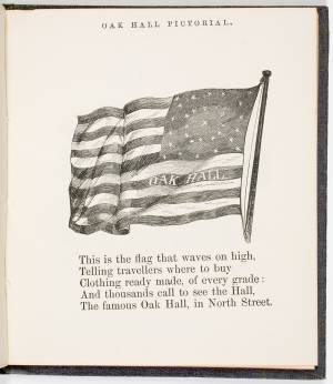
Courtesy American Antiquarian Society, Worcester, Mass. (CL.F9116.011.1854)
Also filed under: Oak Hall »
The Ten Pound Island light was built on a three-and-a-half acre island at the eastern end of Gloucester Harbor. Built as a conical stone tower, the original 20-foot-tall Ten Pound Island Light was first lit in October, 1821 after the Commonwealth of Massachusetts and the Town of Gloucester ceded 1.7 acres to the U.S. Government for the construction of an inner harbor lighthouse to help mariners navigate the harbor. Ten Pound Island light was a popular subject with artists, including Winslow Homer, who boarded with the lighthouse keeper at Ten Pound Island in the summer of 1880. It is frequently featured in Lane's paintings of Gloucester Harbor.
This information has been shared with the Lane project by Jeremy D'Entremont. More information can be found at his website, www.newenglandlighthouses.net or in The Lighthouse Handbook New England. This information has also been summarized from Paul St. Germain's book, Lighthouses and Lifesaving Stations on Cape Ann.


Colored lithograph
Cape Ann Museum Library and Archive
Also filed under: Ten Pound Island »

Photograph
From The Illustrated Coast Pilot with Sailing Directions. The Coast of New England from New York to Eastport, Maine including Bays and Harbors, N. L. Stebbins, 1891.
Also filed under: Ten Pound Island »

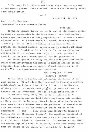
Samuel Elwell Sawyer of Gloucester was a patron of the arts. He visited F. H. Lane’s studio, purchased paintings by him and hired him “to make a sketch of old Homestead for Haughton." (1) Sawyer and Joseph L. Stevens also supported Gloucester artist D. Jerome Elwell in his European studies. We know that in August, 1864, Sawyer ordered two paintings from Lane "to be done [when] he is at leisure," and that he also purchased a painting by Lane for $50 in 1864 at a "Sailors Fare."
Samuel E. Sawyer was born in Gloucester on November 25, 1815 and died at the ancestral homestead in Gloucester on December 15, 1899. He was the fifth generation of Sawyers to occupy Brookbank, an early eighteenth-century gambrel-roofed house located at Freshwater Cove. The Sawyer family history goes back to William Sawyer, who came to New England about 1640.
Samuel's wife was Abigail (Abbie) Ingersoll Meads - they married in Boston on October 30, 1845. They had no children but lived an idyllic life, spending November through March in Boston, and April through October at the family homestead in Gloucester. They spent many years enjoying an accumulated wealth which was generously shared with others. However, life was not always easy for Samuel Sawyer, as he started at the bottom and suffered several financial reversals along the way before becoming financially secure.
Sawyer began his business career as a clerk in Samuel Stevens' dry goods store on Main Street in Gloucester. (2) He soon went to Boston, where he secured a job as a salesman with the firm Kimball and Jewett. He then entered the field of shipping and commerce, and became a partner in the firm of Haughton, Sawyer and Adams. This position took him to all parts of the world, and from it he amassed a fortune as a merchant.
Although a good deal of Sawyer's earlier life was spent in Boston and in travel, nothing could entice him away from the scenes of his childhood. At their Freshwater Cove home, he and Mrs. Sawyer enjoyed their middle age and later years. It was during this period of his life that Samuel Sawyer became one of Gloucester's leading philanthropists. His many gifts and bequests ranged from schoolhouse fences to the present clock in the City Hall tower, and from substantial contributions to the Female Charitable Association to a fund that made it possible to introduce music into the public schools. His most memorable gifts were funds for medals to be given annually to students for scholastic excellence, provision of the building and endowment fund for the Sawyer Free Library, and the land now known as Ravenswood Park.
Mr. Sawyer died from pneumonia at the homestead in Gloucester on December 15, 1889 at the age of seventy-four. Mrs. Sawyer had passed away the preceding year, also from pneumonia.
– Mary Rhinelander McCarl and Stephanie Buck
(1) August 25, 1864 in Samuel Sawyer, Diaries: 1854-1874, trans. Mary Rhinelander McCarl.
(2) Obituary of Joseph L. Stevens, Jr., Gloucester Daily Times, September 21, 1908. Samuel Stevens was Joseph L. Stevens, Jr.’s uncle. When Joseph L. Stevens, Jr. came to Gloucester from Maine in 1840, he first worked in his uncle Samuel’s store.
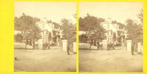
n.d. Stereographic card Cape Ann Museum Library & Archive
Penciled on reverse: "Mansion House, Brook Bank [sic], Sam'l Sawyer now Hammond, Freshwater Cove"
Also filed under: Brookbank » // Historic Photographs »

1834–35 24 x 38 in. Gloucester City Archives
"Drawn on a scale of one hundred feet to an inch. By John Mason 1834–45 from Actual Survey showing every Lott and building then standing on them giving the actual size of the buildings and width of the streets from the Canal to the head of the Harbour & part of Eastern point as farr as Smith's Cove and the Shore of the same with all the wharfs then in use. Gloucester Harbor 1834–35."
This map is especially helpful in showing the wharves of the inner harbor at the foot of Washington Street.
Typescript
Sawyer Free Library, Gloucester, Mass.
Also filed under: Gloucester Lyceum » // Sawyer Free Library »
Cape Ann Museum Library & Archives
Also filed under: Diaries / Ledgers / Etc. »
Samuel Sawyer Papers
Cape Ann Museum Library & Archives
Archive Collection exp013
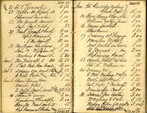
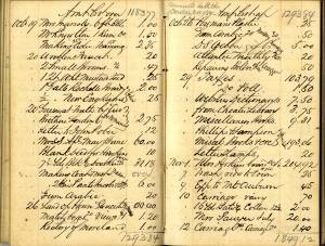
"November 27. Engraving. Arch of Triumph (To James 1/53)
Engraving. Pharaoh’s Horses Painting. Seaview
Traveller & milkmaid. Companions. Hogarth. $2."
Also filed under: Diaries / Ledgers / Etc. » // Lithography (Sales & Exhibitions) »
Samuel Sawyer Papers
Cape Ann Museum Library & Archives
Archive Collection exp014
"November 12. Village Festival
Banck. Sunrise 3.25, Sunset Backhuysen. Sea view, Power of Fashion, Cattle piece. 3 gilt frames"
Also filed under: Diaries / Ledgers / Etc. »
Samuel Sawyer Papers
Cape Ann Museum Library & Archives
Archive Collection exp015
"June 6. 2 Dutch coast scenes & frames. Fremart(?) (One Haughton)"
Also filed under: Diaries / Ledgers / Etc. » // Haughton, James »
Samuel Sawyer Papers
Cape Ann Museum Library & Archives
Archive Collection exp016
"November 8. Lane. Homestead
Frame at Balch
Museum &c. &c."
Also filed under: Balch, William Y. » // Diaries / Ledgers / Etc. »
Samuel Sawyer Papers
Cape Ann Museum Library & Archives
Archive Collection exp017
"June 4. Interior. Peter Neefs
Landscape. Mireveldt Amsterdam. A. Storck
Flower piece. Unknown
Female head. L. Baker
Flowers, bird’s nest.
Schlesinger Flemish peasants. Unknown"
Also filed under: Diaries / Ledgers / Etc. »
Newsprint
From bound volume owned by publisher Francis Procter
Collection of Fred and Stephanie Buck
"A CARD. – The Ladies of Gloucester who are interested in the Lyceum Library, and who projected the recent Festival in its behalf, take this method of returning their sincere acknowledgements;
To Messrs. F. H. Lane, Addison Center and John Trask for their arduous and truly artistic labors in the preparation of Tableaux; . . .
To Robert Fears, Esq., who gratuitously opened his large and commodious Sail Loft for their use and exerted himself to make their occupancy of it agreeable;...
To Samuel Sawyer, Esq. of Boston, for his generous and unexpected donation of fifty dollars, thereby laying the Library under still another obligation to him;...
Also filed under: Center, Addison » // Fears, Robert » // Gloucester Lyceum » // Newspaper / Journal Articles » // Trask, John »
Samuel Sawyer Papers
Cape Ann Museum Library & Archives
Archive Collection exp018
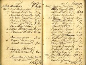
"November 12. Winter scene, Scotch boy
Landscape. Griggs Rising by Frost
Chip off the Old Block, Infant Saviour
St. John Dilemma. Rondel
Departure"
Also filed under: Diaries / Ledgers / Etc. »
Samuel Sawyer Papers
Cape Ann Museum Library & Archives
Archive Collection exp020
"Marine View Mt. Desert Light Lane $41.00"
Also filed under: Diaries / Ledgers / Etc. » // Mount Desert, Maine – Mount Desert Rock Light »
Samuel Sawyer Papers
Cape Ann Museum Library & Archives
Archive Collection
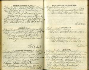
"After dinner went to the Athanaum[sic]."
Also filed under: Boston – Boston Athenaeum » // Diaries / Ledgers / Etc. »
Samuel Sawyer Papers
Cape Ann Museum Library & Archives
Archive Collection
"February 4. Went to the artists reception this evening. There was a large company. Haven (?) Fields Whipple & Co. We enjoyed the occasion very much. Our invitation came from Mr. Scott, Mr. Bartlett & Lottie also went, Mrs. Haughton did not."
Also filed under: Diaries / Ledgers / Etc. » // Haughton, James » // Scott, John W. A. »
Samuel Sawyer Papers
Cape Ann Museum Library & Archives
Archive Collection
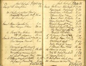
"November 17. Went to Gloucester. Pleasant morning, rainy evening.
Called upon Mr. Lane artist."
Also filed under: Diaries / Ledgers / Etc. »
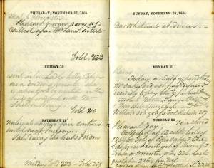
"November 23. Cool & pleasant. Went to Gloucester.
Size of Haughton's pictures 2. 18 x 30 & 1. 10 x 15. [Lane?]"
Also filed under: Diaries / Ledgers / Etc. » // Haughton, James »
Samuel Sawyer Papers
Cape Ann Museum Library & Archives
Archive Collection A#63
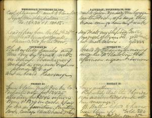
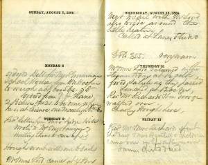
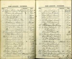
"Got painting. Lane's $50. For Mrs. Cowes. National Sailors Fair."
Also filed under: Boston – 1864 Sailors' Fair » // Cores [Cowes?] Mrs. » // Diaries / Ledgers / Etc. »
Samuel Sawyer Papers
Cape Ann Museum Library & Archives
Archive Collection
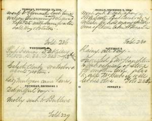
"December 2. Went out to call upon J. W. A. Scott East Cambridge artist. He had many sketches. Some of them taken at Gloucester."
Also filed under: Diaries / Ledgers / Etc. » // Scott, John W. A. »
Samuel Sawyer Papers
Cape Ann Museum Library & Archives
Archive Collection
"March 17. Delightful weather.
One of Lane’s Pictures sold at Leonard’s for $55"
Also filed under: Boston – 1864 Joseph Leonard & Co. » // Diaries / Ledgers / Etc. »
Samuel Sawyer Papers
Cape Ann Museum Library & Archives
Archive Collection
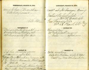
"Rosa Bonheur called" [According to Mary McCarl, this was the name of Sawyer's cow]
Also filed under: Diaries / Ledgers / Etc. »
Samuel Sawyer Papers
Cape Ann Museum Library & Archives
Archive Collection
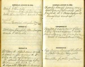
"August 15. Mr. & Mrs. H.(Haughton) staid over, went to sail in the morning & to ride in the afternoon. H. ordered 3 paintings of Mr. Lane for $150, 2 size about 18 x 30, & 1 small."
Also filed under: Diaries / Ledgers / Etc. » // Haughton, James »
Samuel Sawyer Papers
Cape Ann Museum Library & Archives
Archive Collection
"August 25. Called to see Mr. Lane to make a sketch of old Homestead for Haughtons."
Also filed under: Brookbank » // Diaries / Ledgers / Etc. » // Haughton, James »
Samuel Sawyer Papers
Cape Ann Museum Library & Archives
Archive Collection
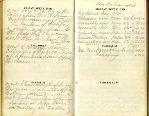
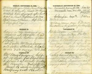
"Monday 8th
Ordered from F. H. Lane 2 Pictures 14 x 21 to be done when he is at leisure. One moonlight $25-$30. . .
Tuesday 9th
Called at Lane's studio"
Also filed under: Diaries / Ledgers / Etc. »
Samuel Sawyer Papers
Cape Ann Museum Library & Archives
Archive Collection
"Mr. [F.H. Lane - crossed out] Lane came over to draw the outline for picture for Haughton"
Also filed under: Diaries / Ledgers / Etc. » // Haughton, James »
Samuel Sawyer Papers
Cape Ann Museum Library & Archives
Archive Collection A#63
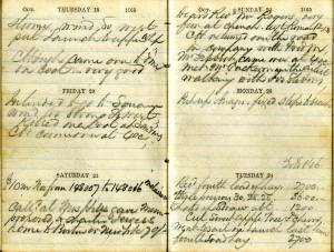
"Lane Picture Mrs. Cowes $50
Frame for same $18"
Also filed under: Boston – 1864 Sailors' Fair » // Cores [Cowes?] Mrs. » // Diaries / Ledgers / Etc. »
Samuel Sawyer Papers
Cape Ann Museum Library & Archives
Archive Collection
"Met Mr. Tuckerman the artist walking with Jos. Stevens."
Also filed under: Diaries / Ledgers / Etc. » // Stevens, Joseph, Jr. » // Tuckerman, Stephen Salisbury »
Marks: Inscribed upper left (in red ink): 93 [numbering system used by curator A. M. Brooks upon Samuel H. Mansfield's donation of the drawings to the Cape Ann Museum]