An online project under the direction of the CAPE ANN MUSEUM
Catalogue Entry
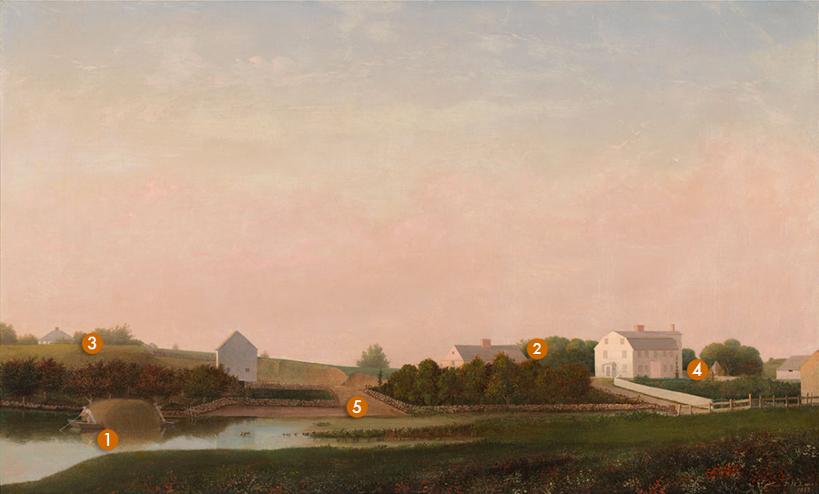
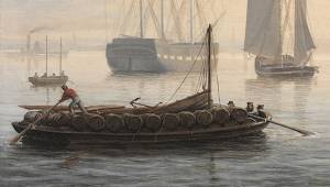
Both this painting and the related work The Babson Meadows at Riverdale, 1863 (inv. 11) show the house and property of the Babson family in the Town Parish area of Gloucester. Though both houses are still standing on Washington Street, they abut an area of countryside and salt marsh in the foreground that has become a large traffic rotary (Grant Circle). The paintings were companions (along with a third believed to be lost) and were commissioned by the Babsons, a prominent Gloucester family.
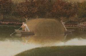
The notes on the drawings indicate that these two works were painted in 1863 for the Babson sisters before their move west to California and served as a remembrance of their home. The scene is a seemingly straightforward account of the Babson house on the right, lit up by the late afternoon sun, and the Ellery house, partially hidden by trees with a barn across the road. The broad town landing comes down to the water where a gundalow full of late summer marsh hay is being poled in to unload.
Babson and Ellery Houses, Gloucester is a masterpiece of serenity and order. The Babson house is a substantial gambrel-roofed New England house; simple, dignified and solid. The eye is led up to the house by the diagonal of the board fence enclosing the garden, all bathed in the pink light of a late summer evening. Moving to the left the gable end of the Ellery house sticks up out of the trees and across the road is the barn in shadow, a sliver of light reflecting off its west side.
Lane has integrated the horizontal composition by stitching it together with the stone walls (each stone obsessively drawn and shaded) that organize the spaces and lead the eye along the roads and into the distance. The walls define rectilinear areas that echo the geometry of the buildings and their enclosures giving order to what could otherwise have been a bland expanse.
The foreground is another example of Lane’s remarkable ability to make a mass of indiscriminate plants and grasses into a delicate botanical tapestry. There is a vaporous pink atmosphere in the sky reflected on the roads and every lit surface in contrast to the diversity of dark greens across the landscape.
This can be called one of Lane’s “perfect” paintings. Every element is locked together in harmony; composition, color and tonal values. The eye is led around a complete and perfect world. There is a great feeling of nostalgia to this work. One can imagine Lane consciously evoking that sentiment on behalf of the departing Babson sisters. Lane himself was nearing the end of his life and the restrained but obvious emotion in this painting has a clear relationship with his elegiac Brace’s Rock series done only a year or so later, just before his death in 1865.
– Sam Holdsworth
- Subject Types
: - Landscape Types
: - Vessel Types
: - Cape Ann Locales
: - Activities of People
:
Historical Materials
1863 Oil on canvas 22 x 36 in. Cape Ann Museum, Gloucester, Mass., Gift of Roger W. Babson, 1937 (779.02)
Detail showing a flat-bottomed gundalow loaded with marsh hay and being propelled by men with long sweeps.
Filed under: Babson House » // Gundalow / Scow » // Salt Marsh Hay / English Hay »
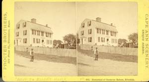
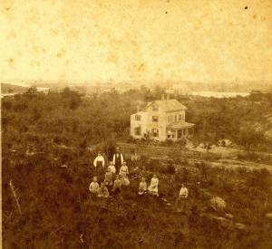
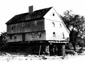
Traditionally known as the Babson-Alling House, this two-and-a-half-story gambrel-roofed structure was constructed in 1740 for Joseph Allen, Jr., a successful merchant and land owner, and his family. It is located at what was once Gloucester’s Town Green, the center of civic and religious life during the Colonial era. The gable end of the house sits parallel to Washington Street and the front façade faces south. By Lane’s time, the house was occupied by the Babson family; the fields surrounding it were given over to haying, gardens, and grazing of cows. Shortly before Nathaniel Babson's death in 1863, ownership of the Babson House was taken over by Maria and Emma's uncle, Gustavus Babson (1820–97). The Babson House is now owned by the Cape Ann Museum.
– Martha Oaks (May, 2015)
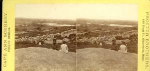
Stereograph card Cape Ann Museum Library & Archive
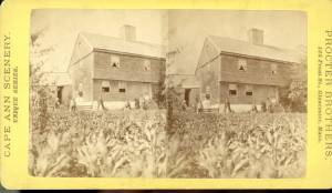
Stereo view of the house owned by Nathaniel Babson (Emma and Maria). The house was sold to Gustavus shortly before Nathaniel's death.
Also filed under: Babson, Nathaniel » // Historic Photographs »
1863 Oil on canvas 22 x 36 in. Cape Ann Museum, Gloucester, Mass., Gift of Roger W. Babson, 1937 (779.02)
Detail showing a flat-bottomed gundalow loaded with marsh hay and being propelled by men with long sweeps.
Also filed under: Gundalow / Scow » // Salt Marsh Hay / English Hay »
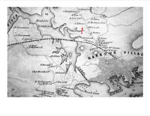
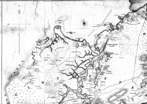
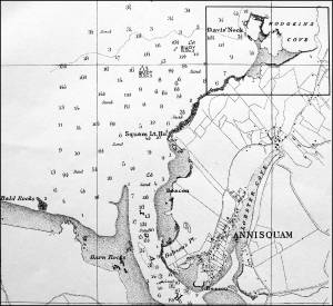
1851 44 x 34 in. Henry Francis Walling, Map of the Towns of Gloucester and Rockport, Essex Co. Massachusetts. Philadelphia, A. Kollner, 1851 Cape Ann Museum Library & Archive
"Map of the Towns of Gloucester and Rockport, Massachusetts. H.F. Walling, Civil Engineer. John Hanson, Publisher. 1851. Population of Gloucester in 1850 7,805. Population of Rockport in 1850 3,213."
Also filed under: Cut, The (Stacy Blvd.) » // Town / Public Landings » // White-Ellery House »
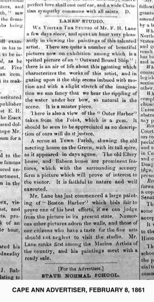
2.8.1861 Newsprint From bound volume owned by publisher Francis Procter Collection of Fred and Stephanie Buck
"We visited the studio of Mr. F.H. Lane a few days since, and spent an hour very pleasantly in viewing the paintings of this talented artist. There are quite a number of beautiful pictures now on exhibition among which is a spirited picture of an 'Outward Bound Ship'; there is an air of life about this painting which characterizes the works of this artist, and in gazing upon it the ship seems imbued with motion and with a slight stretch of the imagination we can fancy that we hear the rippling of the water under her bow, so natural is the scene. It is a master piece.
There is also a view of the 'Outer Harbor' taken from the Point, which is a gem. It should be seen to be appreciated as no description of ours will do it justice.
A scene at Town Parish, showing the old meeting house on the Green, with its tall spire, as it appeared in days agone. The old Ellery house, and Babson House are prominent features, which with the surrounding scenery form a picture which will prove of interest to the visitor. It is faithful to nature and well executed.
Mr. Lane has just commenced a large painting of 'Boston Harbor' which bids fair to prove one of his best efforts, if we can judge from the picture in its present state. Numerous other pictures adorn the walls, and those of our citizens who have a taste for the fine arts should not neglect to visit the studio. Mr. Lane ranks among the Marine Artists of the country, and his paintings meet with a ready sale."
Also filed under: Newspaper / Journal Articles » // Studio Descriptions »
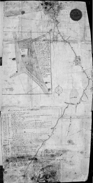
1823 Cape Ann Museum Library & Archive Grayscale version of color original
Map of Riverdale from the Mills to the Whittemore House at Middle and Washington Streeets ordered by a committee of selectmen, William Pearce, Samuel Stevens, Daniel H. Rogers with John Mason and Anthony Presson. Map drawn by surveyor William Saville and present to the committee in June, 1823. It contains a enlarged view of The Green, including the Ellery and Babson houses painted by Lane.
Also filed under: Low (David) House » // Maps » // Meetinghouse Green » // Riverdale / Town Parish » // Riverdale Mills »
1851 44 x 34 in. Henry Francis Walling, Map of the Towns of Gloucester and Rockport, Essex Co. Massachusetts. Philadelphia, A. Kollner, 1851 Cape Ann Museum Library & Archive
"Map of the Towns of Gloucester and Rockport, Massachusetts. H.F. Walling, Civil Engineer. John Hanson, Publisher. 1851. Population of Gloucester in 1850 7,805. Population of Rockport in 1850 3,213."
Also filed under: Annisquam River » // Coffin's Beach » // Eastern Railroad » // Gloucester, Mass. – Annisquam Harbor Lighthouse » // Granite Quarrying / Shipping » // Loaf, The » // Low (David) House » // Maps » // Old First Parish / Subsequent Fourth Parish Church (at the Green) » // Riverdale Methodist Church (Washington Street) » // White-Ellery House »
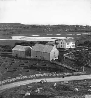
c.1869 Stereograph card Cape Ann Museum Library & Archive
View of the Babson Farm taken from Pole's Hill, showing the old Murray Meeting House (rear section of barn), fields and Mill River. In the background is the skyline of the major buildings at Harbor Village, including the first version of City Hall destroyed by fire in 1869.
Also filed under: Riverdale / Town Parish » // Universalist (Original) Meeting House (Sargent) »

Video tour, Cape Ann Museum, 2022
This short video tour provides an overview of the Babson-Alling House (c. 1740).
This video, along with virtual tours of the White-Ellery House, and the Captain Elias Davis House were generously funded by a grant from MassHumanities.
The David Low house appears in Lane's Babson and Ellery Houses, Gloucester, 1863 (inv. 10); it was located near the current corner of Washington Street and Cunningham Road. The roof and chimney peek up over the hill and field at the far left of canvas, above the man in the gundalow. It no longer exists, but it stood where Cunningham Road now leaves Washington Street, between Grant Circle and Addison Gilbert Hospital.
David Low, the son of John Low Jr. and Sarah "Gee," was born in 1759. He married Elizabeth Rogers in 1786 and they had fourteen children. By 1863, both David Low and Elizabeth were dead, but three of their daughters inhabited the house. It was these three sisters, Mary, Lucy and Sally/Sarah Low, about whom Lane's posthumous promoter, Alfred Mansfield Brooks, wrote, referring to them as the sisters of Captain Gorham Low:
"The Low house was a three-story Federal in which each sister occupied a floor wholly her own except for the parlor, which was reserved for callers, tea parties and funerals. A fine Copley portrait hung in this parlor, and Grandmother remembered how it was always rubbed over with a rind of fresh pork to make it shine when company was expected. I was taken in and shown as 'Abby's boy,' which I hated, and then expected to sit silent during each of the three visits, which I hated even more. Precisely the same length of time to the minute was exacted by the old ladies, else, as Great-Aunt Sarah said, they would never overlook the slight."
In the early twentieth century, after the deaths of the sisters, the house left the Low family and was owned by Edith and then Florence Cunningham, but was eventually torn down to allow for the creation and development of Cunningham Road in the 1950s.
– Sarah Dunlap (September, 2013)
1823 Cape Ann Museum Library & Archive Grayscale version of color original
Map of Riverdale from the Mills to the Whittemore House at Middle and Washington Streeets ordered by a committee of selectmen, William Pearce, Samuel Stevens, Daniel H. Rogers with John Mason and Anthony Presson. Map drawn by surveyor William Saville and present to the committee in June, 1823. It contains a enlarged view of The Green, including the Ellery and Babson houses painted by Lane.
Also filed under: Babson House » // Maps » // Meetinghouse Green » // Riverdale / Town Parish » // Riverdale Mills »
1851 44 x 34 in. Henry Francis Walling, Map of the Towns of Gloucester and Rockport, Essex Co. Massachusetts. Philadelphia, A. Kollner, 1851 Cape Ann Museum Library & Archive
"Map of the Towns of Gloucester and Rockport, Massachusetts. H.F. Walling, Civil Engineer. John Hanson, Publisher. 1851. Population of Gloucester in 1850 7,805. Population of Rockport in 1850 3,213."
Also filed under: Annisquam River » // Babson House » // Coffin's Beach » // Eastern Railroad » // Gloucester, Mass. – Annisquam Harbor Lighthouse » // Granite Quarrying / Shipping » // Loaf, The » // Maps » // Old First Parish / Subsequent Fourth Parish Church (at the Green) » // Riverdale Methodist Church (Washington Street) » // White-Ellery House »
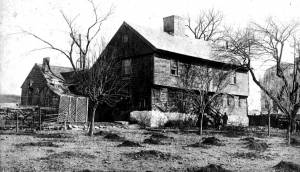
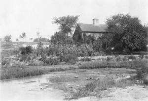
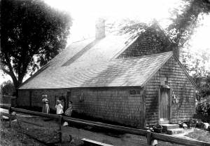
The White-Ellery House was built in 1710 and is one of just a handful of First Period houses in Eastern Massachusetts that survives to this day with much of its interior detail intact. (First Period means c.1620–1725.) It is a two-story “saltbox” structure with a massive central chimney that once serviced six fireplaces. Stepping inside today, visitors enter much the same house they would have 300 years ago.
The White-Ellery House is on the National Register of Historic Sites because of its unique construction and important interior features. The most important elements of the House include the following:
·Vertical plank frame construction.
·A framed overhang on the front façade.
·Elaborate chamfering (decorative plane work) on ceiling beams, particularly on the first floor.
·Three different examples of painted wall decoration.
·Renaissance-inspired architectural features illustrating the transition from European building traditions to early American ones.
·Very rare examples of raised-field paneled doors between rooms on the first floor.
·Unusually elaborate bolection moldings around fireplaces.
·Several examples of original clay plaster (with hair and eel grass), and skim coat of lime plaster.
·An integral lean-to roof (built at the same time as the rest of the structure).
·One of the most highly developed front staircases of the period in Eastern Massachusetts.
The White-Ellery House was built for the Reverend John White (1677–1760), brother-in-law of Cotton Mather, former Chaplain at Fort Saco, author of New England's Lamentations (1734) and Gloucester’s first settled minister. In keeping with White’s esteemed position in the community, the House exhibits a certain elegance and refinement, perhaps best reflected in the surviving interior details.
At the time the House was constructed, the surrounding area was Gloucester’s Town Green–the center of the community. The Reverend White’s church, also called a meeting house, was located on the green and most of the townspeople lived in the immediate area. The Annisquam River was readily accessible and was an important means of transportation for early residents, most of whom were farmers or simple tradesmen, and their families.
The second owner of the White-Ellery House was James Stevens who kept it as a tavern between 1735 and 1740. The House was owned next by the Ellery family who retained ownership of it until 1947. Although the center of Gloucester long ago moved from the Town Green to the Harbor Village, the site remains the entrance to Gloucester and an important historical site.
The barn alongside the White-Ellery House is also a First Period structure, built in the mid-1730s, exhibiting the same early construction techniques as the House. Recently it has undergone stabilization work by students in the Preservation Carpentry Program at the North Bennet Street School; further work will focus on preservation of the exterior.
1851 44 x 34 in. Henry Francis Walling, Map of the Towns of Gloucester and Rockport, Essex Co. Massachusetts. Philadelphia, A. Kollner, 1851 Cape Ann Museum Library & Archive
"Map of the Towns of Gloucester and Rockport, Massachusetts. H.F. Walling, Civil Engineer. John Hanson, Publisher. 1851. Population of Gloucester in 1850 7,805. Population of Rockport in 1850 3,213."
Also filed under: Babson House » // Cut, The (Stacy Blvd.) » // Town / Public Landings »
In 1947, plans were unveiled showing the soon-to-be-constructed Rte. 128 coming into Gloucester directly through the Town Green and literally on the doorstep of the White-Ellery House. Realizing the House’s importance, the City of Gloucester took it by eminent domain and sold the building to the Cape Ann Historical Museum with the proviso that it be moved immediately. Under the leadership of Museum president Alfred Mansfield Brooks, the House was picked up and moved approximately 100 yards to its present location. For the next decade, Brooks oversaw restoration of the structure, a process which successfully preserved much of the original fabric of the House and which has allowed visitors today to see this gem of First Period architecture, still standing on the edge of Gloucester’s former Town Green.
1851 44 x 34 in. Henry Francis Walling, Map of the Towns of Gloucester and Rockport, Essex Co. Massachusetts. Philadelphia, A. Kollner, 1851 Cape Ann Museum Library & Archive
"Map of the Towns of Gloucester and Rockport, Massachusetts. H.F. Walling, Civil Engineer. John Hanson, Publisher. 1851. Population of Gloucester in 1850 7,805. Population of Rockport in 1850 3,213."
Also filed under: Annisquam River » // Babson House » // Coffin's Beach » // Eastern Railroad » // Gloucester, Mass. – Annisquam Harbor Lighthouse » // Granite Quarrying / Shipping » // Loaf, The » // Low (David) House » // Maps » // Old First Parish / Subsequent Fourth Parish Church (at the Green) » // Riverdale Methodist Church (Washington Street) »
Stereoview card Cape Ann Museum Library & Archive
Also filed under: Historic Photographs »

Video tour of the White-Ellery House, Cape Ann Museum, 2022
This short video tour provides an overview of the White-Ellery House (1710).
This video, along with virtual tours of the Captain Elias Davis House, and the Babson-Alling House were generously funded by a grant from MassHumanities.
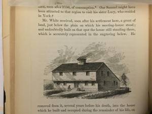
In John J. Babson, History of the Town Gloucester (Gloucester, MA: Procter Brothers, 1860)
See p. 230.
Also filed under: Babson History of the Town of Gloucester »

Technically not a river but a saltwater tidal estuary, the Annisquam (or "Squam") River almost cuts off Cape Ann from the rest of the world. Its constantly flowing tides, and the gleaming expanse of marshes surrounding it, inspired several of Lane's paintings. Marsh hay was harvested along its tidal inlets and provided subject matter for Lane's depiction of this ancient occupation, and the traditional craft associated with it, the gundalow. The Annisquam is connected to Gloucester Harbor by The Cut, also known as the Blynman Canal, which was first dug in the seventeenth century, filled in and opened again to complete the more direct inland passage between the harbor and open ocean.
4 x 5 in.
Cape Ann Museum Library & Archive
#10159
Rare view of a marsh gundalow, being used on the Annisquam River for harvesting salt marsh hay.
Also filed under: Gundalow / Scow »
1851 44 x 34 in. Henry Francis Walling, Map of the Towns of Gloucester and Rockport, Essex Co. Massachusetts. Philadelphia, A. Kollner, 1851 Cape Ann Museum Library & Archive
"Map of the Towns of Gloucester and Rockport, Massachusetts. H.F. Walling, Civil Engineer. John Hanson, Publisher. 1851. Population of Gloucester in 1850 7,805. Population of Rockport in 1850 3,213."
Also filed under: Babson House » // Coffin's Beach » // Eastern Railroad » // Gloucester, Mass. – Annisquam Harbor Lighthouse » // Granite Quarrying / Shipping » // Loaf, The » // Low (David) House » // Maps » // Old First Parish / Subsequent Fourth Parish Church (at the Green) » // Riverdale Methodist Church (Washington Street) » // White-Ellery House »
1870s Stereograph card Cape Ann Museum Library & Archive
Also filed under: Historic Photographs »

44 x 34 in.
Henry Francis Walling, Map of the Towns of Gloucester and Rockport, Essex Co. Massachusetts. Philadelphia, A. Kollner, 1851
Cape Ann Museum Library & Archive
"Map of the Towns of Gloucester and Rockport, Massachusetts. H.F. Walling, Civil Engineer. John Hanson, Publisher. 1851. Population of Gloucester in 1850: 7,805. Population of Rockport in 1850: 3,213."
Also filed under: Brookbank » // Dolliver's Neck » // Fresh Water Cove » // Gloucester Harbor, Outer » // Maps » // Norman's Woe » // Stage Rocks / Stage Fort / Stage Head » // Steepbank » // West Gloucester – Little River » // Western Shore »
Also filed under: Davis' Neck »
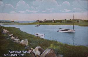
Postcard
Cape Ann Museum Library & Archive
Also filed under: Riverdale / Town Parish »
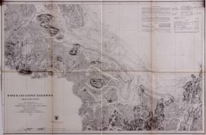
Survey of the Coast of the United States, Washington, D.C.
Collection of Erik Ronnberg
Also filed under: Maps »
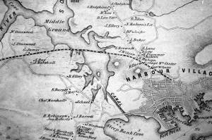
Gloucester’s First Parish was started here in 1641 when Pastor Blynman and his dissident group left the Plymouth Colony to start anew on Cape Ann. They were focused on agriculture, not fishing, and chose this relatively flat area of Cape Ann for its soil, fresh water, and relative protection from the sea weather to start their colony and build their first church. It was another fifty years before fishing began in earnest and the population gradually moved to the harbor area. This left Meetinghouse Green as a quiet pocket of small farms and tidal mills seemingly worlds away from the bustling harbor.
The Green, as it was commonly called, was located between the Annisquam River at Done Fudging and the head of the tidal Mill River to the north. The first meetinghouse on Cape Ann was built there in the 1640s, replaced by a successor built in 1752 which lasted until the 1840s when it was taken down for lack of funds and parishioners. The southern side of the Green is now almost completely obliterated by the Grant Circle rotary just over the Route 128 bridge as it comes onto Cape Ann. The northern side of the Green was up Washington St. from the rotary and occupied the present site of Addison Gilbert Hospital and the neighborhoods around it. The only structure left from the days when The Green was the town center is the Ellery House, which is now on the east side of Washington Street. This house is now owned by the Cape Ann Museum.
In Lane’s day there was a public landing on the Annisquam River at Done Fudging where the rotary now sits. Washington Street came north from the harbor and followed its present day route up the hill between the Babson house and Ellery house (moved to the east side of the street in 1953) and onto the Green. It was a quiet rural area in Lane’s time in contrast to the intense activity and swelling population of the harbor town.
Lane painted a number of pictures of this area, starting in the late 1840s with several self portraits of him painting in the landscape looking west from Done Fudging up the Annisquam River. Nowhere is the serene nature of this area better expressed than in two of Lane’s late views, Babson and Ellery Houses, Gloucester, 1863 (inv. 10) and The Babson Meadows at Riverdale, 1863 (inv. 11). The former shows the town landing at Done Fudging with a pole barge full of salt hay and the two prominent old houses flanking Washington Street. The view in Riverdale is taken from the north edge of The Green and looks up Mill River towards Riverdale in the distance.
1823 Cape Ann Museum Library & Archive Grayscale version of color original
Map of Riverdale from the Mills to the Whittemore House at Middle and Washington Streeets ordered by a committee of selectmen, William Pearce, Samuel Stevens, Daniel H. Rogers with John Mason and Anthony Presson. Map drawn by surveyor William Saville and present to the committee in June, 1823. It contains a enlarged view of The Green, including the Ellery and Babson houses painted by Lane.
Also filed under: Babson House » // Low (David) House » // Maps » // Riverdale / Town Parish » // Riverdale Mills »
Lithograph
28.5 x 21 in.
Cape Ann Museum Library & Archive
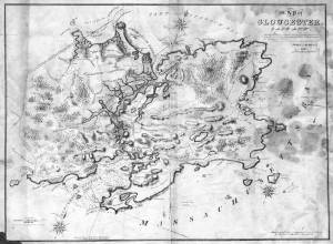
When Massachusetts decreed that each town be mapped, John Mason drew the map of Cape Ann in 1830. This drawing was sent to the Senefelder Lithographic Company of Boston (owned by William Pendleton) to be printed, and then sold in Gloucester by W.E.P. Rogers, whose Gloucester Telegraph of February 12, 1831 announced, "A few specimen copies of the map, uncolored, have reached the town" and that they cost $1.25. Perhaps this business arrangement between Pendleton and Rogers provided Lane with his introduction to Pendleton.
Also filed under: Folly Cove » // Good Harbor Beach / Bass Rocks » // Maps » // Mason, John » // Pendleton's, Lith. – Boston » // Salt Island » // Thacher Island »
Riverdale is one of Gloucester’s many neighborhoods. Although its boundaries have never been formally set, it runs from the historic Town Green north around the shores of the Mill River. Dogtown is upland and Wheeler’s Point is to the west. Landmarks in the neighborhood over the years have included a dam built across the upper end of the Mill River; a corn mill which ran off tidal waters that flowed out of a pond created by the dam; Poles Hill, a huge granite outcropping at the intersection of what are now Wheeler and Washington Streets; a Methodist meeting house; and the original Town Green. A history of the neighborhood, privately printed in 1950 and available in the archives of the Cape Ann Museum, has this to say about the derivation of the name Riverdale:
"This section of the town (of Gloucester) has long borne the name 'Riverdale,' said to have been given it in 1859 by Lodowick H. Bradford, a Boston man who married into the Brown family which then owned the mills. The name does not appear in Babson’s History; he alludes to the section as the 'old town.' It kept its purely Yankee population and character longer than most other parts of the city."
– Martha Oaks (2015)
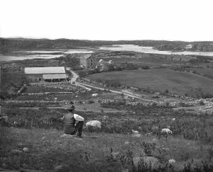
c.1869 Stereograph card Cape Ann Museum Library & Archive
View of the Babson Farm taken from Pole's Hill, showing the old Murray Meeting House (rear section of barn), fields and Mill River. In the background is the skyline of the major buildings at Harbor Village, including the first version of City Hall destroyed by fire in 1869.
Also filed under: Babson House » // Universalist (Original) Meeting House (Sargent) »
1823 Cape Ann Museum Library & Archive Grayscale version of color original
Map of Riverdale from the Mills to the Whittemore House at Middle and Washington Streeets ordered by a committee of selectmen, William Pearce, Samuel Stevens, Daniel H. Rogers with John Mason and Anthony Presson. Map drawn by surveyor William Saville and present to the committee in June, 1823. It contains a enlarged view of The Green, including the Ellery and Babson houses painted by Lane.
Also filed under: Babson House » // Low (David) House » // Maps » // Meetinghouse Green » // Riverdale Mills »
Postcard
Cape Ann Museum Library & Archive
Also filed under: Annisquam River »
From Colonial times to the present, Gloucester and other shore-side communities have maintained certain tracts of land as public landings, assuring everyone the right of free access to and from tidal waters. Such ways are carefully delineated in deeds, are to be kept clear of encumbrances and be available for all to pass over. For communities like Gloucester whose economies were based solidly on maritime pursuits throughout the eighteenth and nineteenth centuries, allowing access to navigable waters was essential.
Public landings were designated across Cape Ann including at Folly Cove, the historic Town Green, Done Fudging, Lobster Cove, Cripple Cove and Stanwood Point in West Gloucester. While public access to the water has gradually constricted in recent decades, even during Fitz Henry Lane’s lifetime, landowners guarded their property rights fiercely, making public landings all that more important.
Gloucester's first public landing was on the Annisquam River at the site of the old First Parish (now occupied by the Grant Circle rotary where Route 128 intersects Washington Street). Given the shallows of the river, most goods had to be landed in scows or gundalows—goods such as marsh hay, lumber, livestock, domestic needs, and business wares—in short, everything from the rest of the world.
As one of the earliest pockets of settlement in Gloucester, Fresh Water Cove was another logical and practical place for a public landing to be located and indeed one was laid out there by the town’s founders. It was over that tract of land that granite from the upland quarry, located in what is now Ravenswood, was transported to awaiting sloops in the Cove. The landing was also how shore fishermen would access their boats and carry supplies to and from their homes.
– Martha Oaks
1851 44 x 34 in. Henry Francis Walling, Map of the Towns of Gloucester and Rockport, Essex Co. Massachusetts. Philadelphia, A. Kollner, 1851 Cape Ann Museum Library & Archive
"Map of the Towns of Gloucester and Rockport, Massachusetts. H.F. Walling, Civil Engineer. John Hanson, Publisher. 1851. Population of Gloucester in 1850 7,805. Population of Rockport in 1850 3,213."
Also filed under: Babson House » // Cut, The (Stacy Blvd.) » // White-Ellery House »

1834–35 24 x 38 in. Gloucester City Archives
"Drawn on a scale of one hundred feet to an inch. By John Mason 1834–45 from Actual Survey showing every Lott and building then standing on them giving the actual size of the buildings and width of the streets from the Canal to the head of the Harbour & part of Eastern point as farr as Smith's Cove and the Shore of the same with all the wharfs then in use. Gloucester Harbor 1834–35."
This map is especially helpful in showing the wharves of the inner harbor at the foot of Washington Street.
Also filed under: Dale, Eben B. » // Eastern Railroad » // Flake Yard » // Gloucester Harbor, Inner / Harbor Cove » // Hough, Benjamin Kent » // Maps » // Pavilion (Publick) Beach » // Ropewalk » // Sawyer, Samuel » // Universalist Church (Middle and Church Streets) »

24 x 38 in.
Gloucester City Archives
"Drawn on a scale of one hundred feet to an inch. By John Mason 1834–45 from Actual Survey showing every Lott and building then standing on them giving the actual size of the buildings and width of the streets from the Canal to the head of the Harbour & part of Eastern point as farr as Smith's Cove and the Shore of the same with all the wharfs then in use. Gloucester Harbor 1834–35."
This map is especially useful in showing the Fort.
Also filed under: Flake Yard » // Fort (The) and Fort Point » // Maps » // Mason, John » // Pavilion (Publick) Beach »

44 x 34 in.
John Hanson, Publisher
Cape Ann Museum Library & Archive
"Map of the Towns of Gloucester and Rockport, Massachusetts. H.F. Walling, Civil Engineer. John Hanson, Publisher. 1851. Population of Gloucester in 1850 7,805. Population of Rockport in 1850 3,213."
Also filed under: Fort (The) and Fort Point » // Low (Frederick G.) wharves » // Maps » // Rogers's (George H.) wharves » // Waterfront, Gloucester » // Windmill »
The rivers of northern New England gave rise to a type of freighting scow called a "gundalow," having square ends, a flat bottom, shallow draft, and sturdy construction going beyond the usual standards for this hull type. The term “gundalow”—variously spelled and pronounced—was first used in the late seventeenth century in New England, and was derived from the Old World term “gondola”—also a flat-bottom vessel, but more varied in hull form and uses. (1)
The rivers and estuaries of Essex County, Massachusetts were subject to tidal variations and their surrounding lowlands were salt marshes which yielded prodigious quantities of grass. The more succulent varieties, called “marsh hay” were valued fodder for livestock, while “thatch,” which grew along the tidal creeks, was used for roofing of buildings, bedding for livestock, and compost for gardens. Grasses on higher elevations could be carted away after cutting, but at lower elevations, it was the job of gundalows to bring it to a landing for distribution. Gundalows for these tasks were relatively small, less than 40 feet in length, propelled by long oars called “sweeps,” and by poles. Occasionally a single square sail was set from a short mast if the landing was distant and downwind. (2)
Larger gundalows, of more elaborate construction, were to be found on the Merrimac and Piscataqua Rivers of Northern Massachusetts and the Maine–New Hampshire boundary, respectively. The Merrimac gundalows probably reached 45–50 feet in length, had long overhangs with a stem post, a skeg with rudder and tiller, heavy framing, and a mast stepped well forward from which a square sail could be set when going downwind. (3)
Not just confined to the Merrimac River, many of these vessels found their ways to the Ipswich marshes via a canal on the mainland side of Plum Island. Smaller and simpler versions of this type were built to work in the salt marshes of Essex and West Gloucester, dispensing with sails and propelled much of the time by poling through narrow tidal creeks. (4)
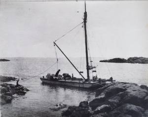
Lane took notice of a gundalow in his painting Babson and Ellery Houses, Gloucester, 1863 (inv. 10) and the remains of another in his Looking up Squam River from Done Fudging, 1850s (inv. 26). In both cases, the hulls are small and simple in detail, but the latter shows part of its heavy inboard construction. Gundalows of this variety survived in Cape Ann estuaries long enough to be photographed.
Piscataqua River gundalows were the largest and most highly developed of this vessel type, measuring 65 feet or more and rigged with a lateen sail set on a very short mast. When sailing under a bridge, the sail could be dipped without lowering and quickly reset once clear. The hull was modeled with a rounded bow and finely shaped stern; many were fitted with a leeboard so the vessel could sail upwind on the broader reaches of the Piscataqua. (5)
Lane’s depiction of a gundalow in Boston Harbor in the mid-1840s is of the type associated with the Piscataqua River, but having features of both earlier and later examples, together with a rig not known to be used on these craft. The “spoon bow” has generally been regarded as a post-1860 feature, yet Lane’s example has one. The stern has a finely modeled transom which is clearly seen in the underdrawing revealed by infrared scanning. Rudders were supposed to be fitted by the early 1800s, but Lane’s example is steered with an oar. The graceful sheer is another feature considered to post-date Lane’s painting. Finally, the rig consists of a gaff- headed sail set from a very short mast. Short fixed masts setting large lateen sails were common to late gundalows, but the gaff rig depicted is so small that its usefulness is limited if not questionable (6).
Close examination of the infrared scans of this image shows careful drafting of the hull and re-drawing of the crew, sweeps, and steering oar. The cargo of casks is also extensively redrawn to show correct stowage. Whether the changes were due to criticisms from others or the artist’s own evaluation is probably lost to history.
– Erik Ronnberg
References:
1. M.H. Parry et al., Aak to Zumbra: The World's Watercraft, (Newport News, VA: The Mariners' Museum, 2000), 264.
2. Ibid.; and Nancy V. Weare, Plum Island: The Way It Was, 2nd ed. (Newbury, MA: Newburyport Press, Inc., 1996), 43–48.
3. D. Foster Taylor, "The Piscataqua River Gundalow," The American Neptune II, no. 2 (April 1942): 127–39.
4. Weare, 43–48.
5. Taylor, 127–39.
6. Ibid.; and author's observations.
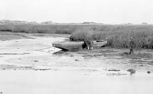
4 x 5 in.
Cape Ann Museum Library & Archive
#10159
Rare view of a marsh gundalow, being used on the Annisquam River for harvesting salt marsh hay.
Also filed under: Annisquam River »
1863 Oil on canvas 22 x 36 in. Cape Ann Museum, Gloucester, Mass., Gift of Roger W. Babson, 1937 (779.02)
Detail showing a flat-bottomed gundalow loaded with marsh hay and being propelled by men with long sweeps.
Also filed under: Babson House » // Salt Marsh Hay / English Hay »
Stereograph
Cape Ann Museum Library & Archive
Also filed under: Granite Quarrying / Shipping »
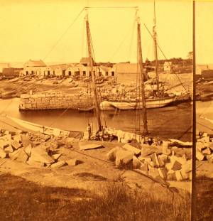
Photograph
Private collection
Granite scow being unloaded at Knowlton's Point, Sandy Bay. Sandy Bay Ledge visible in right background, Dodge's Rock in left background.
Also filed under: Granite Quarrying / Shipping »
From the days of the earliest English settlements on Cape Ann through Fitz Henry Lane’s lifetime, subsistence farmers harvested hay during the summer and autumn months and stored it away to feed livestock during the winter. They also sold it to others in the community for cash or bartered it for other goods and services. Two types of hay were harvested: English hay, meaning hay that was cultivated, and salt marsh hay which was cut from tidal areas where it grew naturally. Many farmers dealt in both. Hay was transported either in wagons drawn by horses or oxen, or by gundalows, flat bottom work boats which could easily maneuver in shallow marsh areas. One example of a family who engaged in haying was the Ellerys who lived at Gloucester’s old Town Green. An account book which Benjamin Ellery (1744–1825) kept is preserved in the archives of the Cape Ann Museum. It reveals that Ellery dealt in both cultivated and natural hay as well as other commodities. He also owned a gundilow, oxen and wagons, all of which he used for his own purposes and made available to others on a barter basis. The practice of haying died out on Cape Ann as automobiles and trucks came into use during the first quarter of the twentieth century and livestock disappeared from the area.
– Martha Oaks (April, 2015)
1863 Oil on canvas 22 x 36 in. Cape Ann Museum, Gloucester, Mass., Gift of Roger W. Babson, 1937 (779.02)
Detail showing a flat-bottomed gundalow loaded with marsh hay and being propelled by men with long sweeps.
Also filed under: Babson House » // Gundalow / Scow »
Emmeline (Emma) Rogers Babson (1839–1905) was born in Gloucester, Massachusetts, the eldest of the two daughters of Nathaniel Babson and Emmeline Davis (Rogers) Babson.
Her mother died when Emma was five and her father, who was a house painter by profession, a selectman, and active in the abolitionist movement, never remarried.
Emma attended the Oread Institute of higher education for women in Worcester, Massachusetts, for one year (her sister Maria attended for one term), before returning to Gloucester, where she brought income into the house as a dressmaker. She married William Hovey Friend (1840–1914) in 1869, and immediately moved to San Francisco, California, where her husband had been residing since 1863. He was a bookkeeper for several firms, and at one time represented the California branch of the Gloucester wholesale fish business of John E. Pew & Sons. In 1896, he became the postmaster of Oakland, California, where he was also trustee and deacon of the First Presbyterian Church for many years. He and Emma had two sons, William Nathaniel Friend, born in 1870 and Roger Berry Friend, born in 1873.
Emma was one of the original organizers of the Ebell Society in 1876 (formed to promote and advance the study by women of literature, science and art), and although suffering from ill health, continued an interest in its affairs until her death. She also helped to organize the Oakland Chapter of the Daughters of the American Revolution, was a member of the General Society of the Mayflower Descendants, and a life member of the YWCA. She was active in the first campaign for woman's suffrage in 1896, and when the Spanish war broke out she was instrumental in organizing the Oakland Red Cross Society, whose first meeting was held at her home. She was also an avid collector of china and wrote authoritatively about it. She wrote many other articles on a variety of subjects, including art. She died in Oakland, California, in 1905.
Lane made paintings for Emma and her sister Maria from three sketches.
Maria Rogers Babson (1840–1913) was born in Gloucester, Massachusetts, the youngest of the two daughters of Nathaniel Babson and Emmeline Davis (Rogers) Babson. She died unmarried in California at the age of seventy-three.
Her mother died when Maria was four and her father, who was a house painter by profession, a selectman, and active in the abolitionist movement, never remarried. Maria and her older sister Emma both briefly attended the Oread Institute of higher education for women in Worcester, Massachusetts—Maria for one term and Emma for one year.
Maria moved to California in 1870, following her sister who had married and moved there the previous year. In California, both sisters became active in a variety of charitable, social and religious organizations. Maria was a charter member of the Ebell Society and Club (formed to promote and advance the study by women of literature, science and art), its General Curator, and indefatigable promoter for many years. She also was prominent in the Oakland Red Cross Society and helped found the Convalescent Home during the Spanish war. She was treasurer of the fund for the children's room in the Carnegie Library and involved in the organization and perpetuation of the Oakland Chapter of the Daughters of the American Revolution. She took a significant interest in the activities, especially the missionary work, of the First Presbyterian Church, being an honorary member of the American Board and an active member of the Occidental Board of Foreign Missions. She died at the home of her nephew in San Francisco on May 1, 1914. (1)
Lane made paintings for Maria and her sister Emma from three sketches.
(1) Past and Present of Alameda County California, Vol. II (Chicago: S. J. Clarke Publishing Company, 1914) , 472-475.
Nathaniel Babson was a Gloucester merchant and a town selectman from 1847 to 1850, and again in 1860. He was a strong supporter of abolition and brought speakers into town to lecture on the subject. He was part owner of two schooners, the "Dianna" in 1855 and the "Flying Cloud" from 1855 to 1859.
According to notes on his drawings, Lane made a painting for Nathaniel Babson of Stage Rocks, and three paintings for his two daughters of their family home.
Nathaniel Babson (1810–63) married Emmeline Davis Rogers (1816–44) on January 16, 1838. He was the son of Capt. Nathaniel Babson and Eliza Gorham Low and a cousin of Edward and John James Babson, his father and their father being brothers. Emmeline was the daughter of Shubael Gorham Rogers and Mary (Davis) Rogers. They had three children: Emmeline Rogers (1839–1903) who married William Hovey Friend; Maria Rogers (1840–1913), who did not marry, and an unnamed daughter who died in the year of her birth, 1844. In the 1860 census, after his wife’s death, Nathaniel Babson was described as a [house] painter and their daughter Emmeline as a dressmaker.
Shortly before his death, ownership of Nathaniel Babson's home went to Maria and Emma's uncle, Gustavus Babson (1820-1897)
.
Stereograph card Cape Ann Museum Library & Archive
Stereo view of the house owned by Nathaniel Babson (Emma and Maria). The house was sold to Gustavus shortly before Nathaniel's death.
Also filed under: Babson House » // Historic Photographs »