An online project under the direction of the CAPE ANN MUSEUM
Catalogue Entry
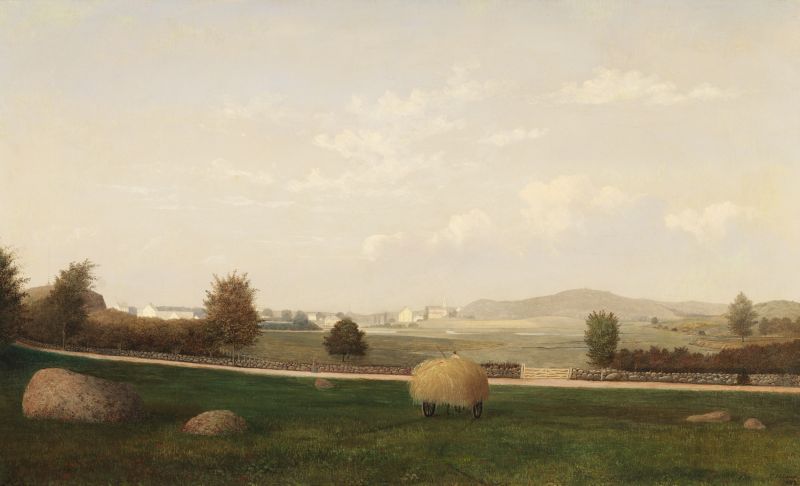
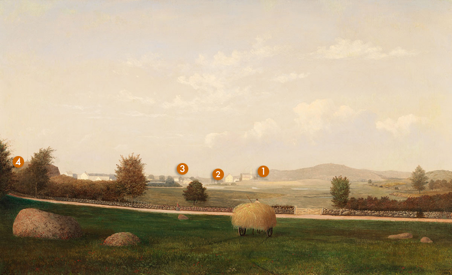
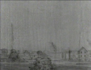
Like Fitz Henry Lane’s Babson and Ellery Houses, Gloucester, 1863 (inv. 10), this picture belonged to the Babson family and was painted for Emmeline (Emma) Rogers Babson and Maria Babson, daughters of Nathaniel and Emmeline Davis Rogers Babson. It shows the view from behind the Babson family homestead, looking out over Poplar Street and the Riverdale marshes.
In the foreground, a wagon heavily laden with hay is shown, alluding to the Babsons’ involvement over the years in the haying business. Poplar Street, which led from Washington Street to Fox Hill (now known as Cherry Street), is delineated by a fieldstone wall, each rock of which Lane has drawn and painted in painstaking detail. In the distance can be seen the Methodist Church and Riggs School, which made up the core of the Riverdale neighborhood. To the right in the distance is Dogtown, the great hogback that makes up the center of Cape Ann. To the left is the large granite outcropping known as Pole’s Hill. A woman can be seen walking along Poplar Street and the head of a man is just visible over the top of the wagonload of hay.
The Babson Meadows at Riverdale has much in common with other works done by Lane during this final chapter of his life. Attention to detail is meticulous, made possible by the rendering of a detailed pencil drawing on the canvas by Lane before paint application. The grandeur of the natural world dominates the canvas, dwarfing man-made intrusions. And the entire scene is bathed in a phosphorescent light that endows the painting with a serene and timeless feel.
The 1860s was a period of change throughout Gloucester and Cape Ann. Fishing took over from foreign trade as the primary business, the population continued to diversify as people from faraway lands filtered in, and many families who had lived in the community for generations sold their land, packed their belongings, and headed West in search of new opportunities. The Babson sisters were part of that westward migration, leaving Gloucester in the late 1860s bound for California, where the lumber and fishing trades were prospering.
The paintings Fitz Henry Lane made for Emma and Maria Babson of their bucolic family homestead ensured that the women would always remember Gloucester and that visitors to their new home would have a sense of their family’s accomplishments back in New England.
– Martha Oaks
Historical Materials
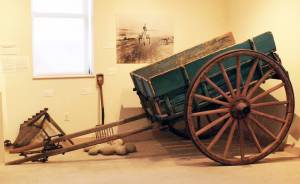
12' 5"l. x 7' I" w. x 4' 9" h.
19th and early 20th c.
Cape Ann Museum. Gift of Thomas A. Robinson, 1983 (2344)
While heavily constructed to transport ballast stone from local beaches, this style of cart was used for many purposes. It is otherwise identical in design to horse-drawn carts depicted in Lane’s paintings.
View related catalogue entries (5) »
Filed under: Objects »
Traditionally known as the Babson-Alling House, this two-and-a-half-story gambrel-roofed structure was constructed in 1740 for Joseph Allen, Jr., a successful merchant and land owner, and his family. It is located at what was once Gloucester’s Town Green, the center of civic and religious life during the Colonial era. The gable end of the house sits parallel to Washington Street and the front façade faces south. By Lane’s time, the house was occupied by the Babson family; the fields surrounding it were given over to haying, gardens, and grazing of cows. Shortly before Nathaniel Babson's death in 1863, ownership of the Babson House was taken over by Maria and Emma's uncle, Gustavus Babson (1820–97). The Babson House is now owned by the Cape Ann Museum.
– Martha Oaks (May, 2015)
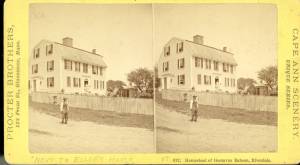
Stereograph card Cape Ann Museum Library & Archive
Stereo view of the house owned by Nathaniel Babson (Emma and Maria). The house was sold to Gustavus shortly before Nathaniel's death.
Also filed under: Babson, Nathaniel » // Historic Photographs »
1863 Oil on canvas 22 x 36 in. Cape Ann Museum, Gloucester, Mass., Gift of Roger W. Babson, 1937 (779.02)
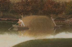
Detail showing a flat-bottomed gundalow loaded with marsh hay and being propelled by men with long sweeps.
Also filed under: Gundalow / Scow » // Salt Marsh Hay / English Hay »
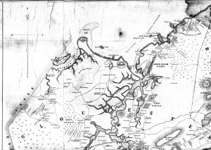
1851 44 x 34 in. Henry Francis Walling, Map of the Towns of Gloucester and Rockport, Essex Co. Massachusetts. Philadelphia, A. Kollner, 1851 Cape Ann Museum Library & Archive
"Map of the Towns of Gloucester and Rockport, Massachusetts. H.F. Walling, Civil Engineer. John Hanson, Publisher. 1851. Population of Gloucester in 1850 7,805. Population of Rockport in 1850 3,213."
Also filed under: Cut, The (Stacy Blvd.) » // Town / Public Landings » // White-Ellery House »
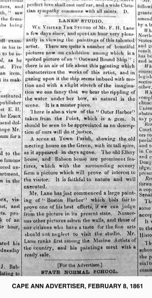
2.8.1861 Newsprint From bound volume owned by publisher Francis Procter Collection of Fred and Stephanie Buck
"We visited the studio of Mr. F.H. Lane a few days since, and spent an hour very pleasantly in viewing the paintings of this talented artist. There are quite a number of beautiful pictures now on exhibition among which is a spirited picture of an 'Outward Bound Ship'; there is an air of life about this painting which characterizes the works of this artist, and in gazing upon it the ship seems imbued with motion and with a slight stretch of the imagination we can fancy that we hear the rippling of the water under her bow, so natural is the scene. It is a master piece.
There is also a view of the 'Outer Harbor' taken from the Point, which is a gem. It should be seen to be appreciated as no description of ours will do it justice.
A scene at Town Parish, showing the old meeting house on the Green, with its tall spire, as it appeared in days agone. The old Ellery house, and Babson House are prominent features, which with the surrounding scenery form a picture which will prove of interest to the visitor. It is faithful to nature and well executed.
Mr. Lane has just commenced a large painting of 'Boston Harbor' which bids fair to prove one of his best efforts, if we can judge from the picture in its present state. Numerous other pictures adorn the walls, and those of our citizens who have a taste for the fine arts should not neglect to visit the studio. Mr. Lane ranks among the Marine Artists of the country, and his paintings meet with a ready sale."
Also filed under: Newspaper / Journal Articles » // Studio Descriptions »
1823 Cape Ann Museum Library & Archive Grayscale version of color original
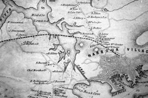
Map of Riverdale from the Mills to the Whittemore House at Middle and Washington Streeets ordered by a committee of selectmen, William Pearce, Samuel Stevens, Daniel H. Rogers with John Mason and Anthony Presson. Map drawn by surveyor William Saville and present to the committee in June, 1823. It contains a enlarged view of The Green, including the Ellery and Babson houses painted by Lane.
Also filed under: Low (David) House » // Maps » // Meetinghouse Green » // Riverdale / Town Parish » // Riverdale Mills »
1851 44 x 34 in. Henry Francis Walling, Map of the Towns of Gloucester and Rockport, Essex Co. Massachusetts. Philadelphia, A. Kollner, 1851 Cape Ann Museum Library & Archive
"Map of the Towns of Gloucester and Rockport, Massachusetts. H.F. Walling, Civil Engineer. John Hanson, Publisher. 1851. Population of Gloucester in 1850 7,805. Population of Rockport in 1850 3,213."
Also filed under: Annisquam River » // Coffin's Beach » // Eastern Railroad » // Gloucester, Mass. – Annisquam Harbor Lighthouse » // Granite Quarrying / Shipping » // Loaf, The » // Low (David) House » // Maps » // Old First Parish / Subsequent Fourth Parish Church (at the Green) » // Riverdale Methodist Church (Washington Street) » // White-Ellery House »
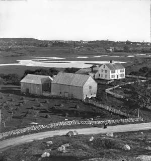
c.1869 Stereograph card Cape Ann Museum Library & Archive
View of the Babson Farm taken from Pole's Hill, showing the old Murray Meeting House (rear section of barn), fields and Mill River. In the background is the skyline of the major buildings at Harbor Village, including the first version of City Hall destroyed by fire in 1869.
Also filed under: Riverdale / Town Parish » // Universalist (Original) Meeting House (Sargent) »

Video tour, Cape Ann Museum, 2022
This short video tour provides an overview of the Babson-Alling House (c. 1740).
This video, along with virtual tours of the White-Ellery House, and the Captain Elias Davis House were generously funded by a grant from MassHumanities.
The Riggs School stood in a meadow on the east side of Mill River, across the street from the Riverdale Mills, on the south side of Reynard Street where it leaves Washington Street. It was built in 1850, and replaced an even earlier school across the street. It is the large white building, just to the left of the distant Methodist church, in Lane's The Babson Meadows at Riverdale, 1863 (inv. 11). Children from much of the Fourth Parish, including Riverdale and Wheeler’s Point, went to this school for their first eight years of primary and grammar school. By 1913, it was the second oldest school standing in Gloucester and needed improvements such as modern toilets, better ventilation and heating, and fire escapes. Lane’s great-great niece, Florence Lane (great-granddaughter of Fitz H. Lane’s brother Edward) attended this school. It was eventually torn down in the late 1950's, and a twenty-first-century development of single-family houses fills the site.
Current location: south corner of Washington and Reynard Streets.
– Sarah Dunlap (September, 2013)
The Riverdale Methodist Church building was the second Methodist church built in Gloucester, and is currently the site of the Gloucester United Methodist Church at 436 Washington Street. The Harbor Methodist had been built in 1828. Ten years later, in 1838, both this and the first Methodist church in Sandy Bay/Rockport were built. The first Methodists had met in Gloucester in 1806, in a nearby Riverdale house then owned by John Edney. For a brief period, 1823–28 or so, Rev. George Pickering held Methodist meetings in the old First Parish meetinghouse at the Green. Lane's mother and brother were active early Methodists, but they attended services at the Harbor Methodist Church, the so-called "Church on the Rock."
The Riverdale Methodist Church was erected by Harris from Ipswich (either Ephraim Harris, 47, carpenter or Isaac T. Harris, 24, housewright). The lumber came from Cambridge on a vessel owned by Captain Levi Cleaves, a Sandy Bay Methodist, and was brought ashore at the Riverdale Mills and hauled the short distance up the hill to the site of the church, on land given by Samuel Curtis.
Internal improvements to the building were made in 1852, but the outer appearance remained unchanged to the time when Lane painted it, in the distance, in his The Babson Meadows at Riverdale, 1863 (inv. 11).
The bell that still hangs in the steeple is the original, hand cast in 1806 by Paul Revere & Son Boston. It originally hung in the Congregational Old Sloop Church in what is now Rockport and was rung to alert the townspeople of an imminent 1814 attack by the British during the War of 1812. In 1840, since the townspeople of Sandy Bay thought the tone of the bell clashed with that of their other bells, it was sold for $156 and moved to this church where it is still rung, despite a thin crack that resulted from a British cannonball hit.
The church caught fire in 1952, but the bell did not fall from the tower. The major portion of the current building is new, including an altar mural by Howard Curtis.
– Sarah Dunlap (September, 2013)
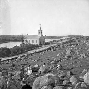
Cape Ann Museum Library & Archive
Riverdale Methodist Church on Washington Street above the Mills. Mill River and Wheeler's Point to left rear distant background Annisquam Point.
Also filed under: Riverdale Mills »
1851 44 x 34 in. Henry Francis Walling, Map of the Towns of Gloucester and Rockport, Essex Co. Massachusetts. Philadelphia, A. Kollner, 1851 Cape Ann Museum Library & Archive
"Map of the Towns of Gloucester and Rockport, Massachusetts. H.F. Walling, Civil Engineer. John Hanson, Publisher. 1851. Population of Gloucester in 1850 7,805. Population of Rockport in 1850 3,213."
Also filed under: Annisquam River » // Babson House » // Coffin's Beach » // Eastern Railroad » // Gloucester, Mass. – Annisquam Harbor Lighthouse » // Granite Quarrying / Shipping » // Loaf, The » // Low (David) House » // Maps » // Old First Parish / Subsequent Fourth Parish Church (at the Green) » // White-Ellery House »
Although earlier mills were built on Mill River, up river in the woods, the site of the Riverdale Mills is supposedly the site of the first tide mill built in Gloucester, a sawmill erected in 1652. A second grist, or corn, mill was added in 1677. They became part of the business enterprise of Rev. John Emerson, pastor of the one church in all of Gloucester from 1663 to 1700. Emerson and his partners were most concerned with the sawmill and with cutting 20,000 board feet from common land timber—their concession from the Town. Later reconstructed versions of those two early mills can be seen in the distance in Lane's painting The Babson Meadows at Riverdale, 1863 (inv. 11) where they appear near the middle of the canvas, peaking over the left top of the solitary green-leafed tree by the stone wall.
The mills seem to have been mostly owned, in the first two centuries, by the Town, with rights to them awarded to capable managers and millers. For a while, around 1706, the mills were run by John Ring and were long known as Ring's Mills, and then as Bennett's Mills. For much of the first third of the nineteenth century, they were managed by the merchant Zachariah Stevens, uncle of Lane's good friend Joseph L. Stevens, Jr. It is not clear who the miller was during his time. Stephen Brown became the miller in 1835. When Lane painted this scene in 1863, the mills were run by Levi Brackett, Stephen Brown, and his son Edward Brown, and they were known as Brown's Mills. Grain was brought in sacks, ground and returned in sacks to the owners, the cost being mostly the miller's wages. Levi Brackett who lived at 372 Washington Street (to the left of the view in Lane's Babson Meadows) and Stephen Brown's son Edward H. Brown ran the mill until after Lane's death.
Brackett retired in 1875 and the mills were sold to Albert Dodge, who owned them into the twentieth century and had two turbine wheels installed which were turned by the out-flowing of the stored-up mill pond water, a source of power that lasted for 12 to 15 hours a day. The mills were torn down in 1926, but an old millstone, presumably from the grist mill, lies near the Richdale's market at 410 Washington Street.
Current location: on causeway over Mill River, between 400 and 410 Washington Street (Rte. 127).
– Sarah Dunlap (November, 2013)
Cape Ann Museum Library & Archive
Riverdale Methodist Church on Washington Street above the Mills. Mill River and Wheeler's Point to left rear distant background Annisquam Point.
Also filed under: Riverdale Methodist Church (Washington Street) »
1823 Cape Ann Museum Library & Archive Grayscale version of color original
Map of Riverdale from the Mills to the Whittemore House at Middle and Washington Streeets ordered by a committee of selectmen, William Pearce, Samuel Stevens, Daniel H. Rogers with John Mason and Anthony Presson. Map drawn by surveyor William Saville and present to the committee in June, 1823. It contains a enlarged view of The Green, including the Ellery and Babson houses painted by Lane.
Also filed under: Babson House » // Low (David) House » // Maps » // Meetinghouse Green » // Riverdale / Town Parish »
The small barn that shows up on the far left of the photograph below was originally a church. The Universalists came into their own when they completed the elegant steepled church at the west end of Middle St. in 1806, but before this they had met in a simple one-storied building at the corner of Water and Spring Street, what is now on Main Street near the Police Station. This was the first Universalist church building in America, and was erected on the farm of Winthrop Sargent by him and thirteen other Gloucester men. It was used from 1780 until 1806, when it was supplanted by the much larger edifice on Middle Street, and this small building was moved to Pearce farm in Riverdale about where the O'Maley baseball field now is laid out. It was torn down in the 1880s after a hurricane damaged it beyond repair. It was known and venerated during Lane's lifetime, however, as the original Universalist church, and when it was demolished, people were said to have saved and made relics of bits of its wood .
–Sarah Dunlap January 2015
c.1869 Stereograph card Cape Ann Museum Library & Archive
View of the Babson Farm taken from Pole's Hill, showing the old Murray Meeting House (rear section of barn), fields and Mill River. In the background is the skyline of the major buildings at Harbor Village, including the first version of City Hall destroyed by fire in 1869.
Also filed under: Babson House » // Riverdale / Town Parish »
Gloucester’s First Parish was started here in 1641 when Pastor Blynman and his dissident group left the Plymouth Colony to start anew on Cape Ann. They were focused on agriculture, not fishing, and chose this relatively flat area of Cape Ann for its soil, fresh water, and relative protection from the sea weather to start their colony and build their first church. It was another fifty years before fishing began in earnest and the population gradually moved to the harbor area. This left Meetinghouse Green as a quiet pocket of small farms and tidal mills seemingly worlds away from the bustling harbor.
The Green, as it was commonly called, was located between the Annisquam River at Done Fudging and the head of the tidal Mill River to the north. The first meetinghouse on Cape Ann was built there in the 1640s, replaced by a successor built in 1752 which lasted until the 1840s when it was taken down for lack of funds and parishioners. The southern side of the Green is now almost completely obliterated by the Grant Circle rotary just over the Route 128 bridge as it comes onto Cape Ann. The northern side of the Green was up Washington St. from the rotary and occupied the present site of Addison Gilbert Hospital and the neighborhoods around it. The only structure left from the days when The Green was the town center is the Ellery House, which is now on the east side of Washington Street. This house is now owned by the Cape Ann Museum.
In Lane’s day there was a public landing on the Annisquam River at Done Fudging where the rotary now sits. Washington Street came north from the harbor and followed its present day route up the hill between the Babson house and Ellery house (moved to the east side of the street in 1953) and onto the Green. It was a quiet rural area in Lane’s time in contrast to the intense activity and swelling population of the harbor town.
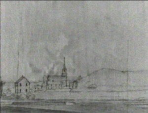
Lane painted a number of pictures of this area, starting in the late 1840s with several self portraits of him painting in the landscape looking west from Done Fudging up the Annisquam River. Nowhere is the serene nature of this area better expressed than in two of Lane’s late views, Babson and Ellery Houses, Gloucester, 1863 (inv. 10) and The Babson Meadows at Riverdale, 1863 (inv. 11). The former shows the town landing at Done Fudging with a pole barge full of salt hay and the two prominent old houses flanking Washington Street. The view in Riverdale is taken from the north edge of The Green and looks up Mill River towards Riverdale in the distance.
1823 Cape Ann Museum Library & Archive Grayscale version of color original
Map of Riverdale from the Mills to the Whittemore House at Middle and Washington Streeets ordered by a committee of selectmen, William Pearce, Samuel Stevens, Daniel H. Rogers with John Mason and Anthony Presson. Map drawn by surveyor William Saville and present to the committee in June, 1823. It contains a enlarged view of The Green, including the Ellery and Babson houses painted by Lane.
Also filed under: Babson House » // Low (David) House » // Maps » // Riverdale / Town Parish » // Riverdale Mills »
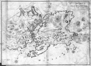
Lithograph
28.5 x 21 in.
Cape Ann Museum Library & Archive
When Massachusetts decreed that each town be mapped, John Mason drew the map of Cape Ann in 1830. This drawing was sent to the Senefelder Lithographic Company of Boston (owned by William Pendleton) to be printed, and then sold in Gloucester by W.E.P. Rogers, whose Gloucester Telegraph of February 12, 1831 announced, "A few specimen copies of the map, uncolored, have reached the town" and that they cost $1.25. Perhaps this business arrangement between Pendleton and Rogers provided Lane with his introduction to Pendleton.
Also filed under: Folly Cove » // Good Harbor Beach / Bass Rocks » // Maps » // Mason, John » // Pendleton's, Lith. – Boston » // Salt Island » // Thacher Island »
This high rocky ledge rises between Mill River and the Annisquam River, between Ferry and Wheeler Streets. The origin of its name is a source of speculation: it might refer to some Powell or Poulle owner in the seventeenth century, and for decades it had a signal pole and then a flag pole erected at its peak. Since the late 1990s, it has been public open space, with access by Sunset Hill Road (off Ferry Street) which becomes a dirt path. One can explore and climb to many high spots on this large hill that overlooks Riverdale, the Annisquam River and its marshes and islands, and obtain lovely views of West Gloucester, the Dogtown woods to the east, and the city buildings to the south.
– Sarah Dunlap (June, 2015)
Riverdale is one of Gloucester’s many neighborhoods. Although its boundaries have never been formally set, it runs from the historic Town Green north around the shores of the Mill River. Dogtown is upland and Wheeler’s Point is to the west. Landmarks in the neighborhood over the years have included a dam built across the upper end of the Mill River; a corn mill which ran off tidal waters that flowed out of a pond created by the dam; Poles Hill, a huge granite outcropping at the intersection of what are now Wheeler and Washington Streets; a Methodist meeting house; and the original Town Green. A history of the neighborhood, privately printed in 1950 and available in the archives of the Cape Ann Museum, has this to say about the derivation of the name Riverdale:
"This section of the town (of Gloucester) has long borne the name 'Riverdale,' said to have been given it in 1859 by Lodowick H. Bradford, a Boston man who married into the Brown family which then owned the mills. The name does not appear in Babson’s History; he alludes to the section as the 'old town.' It kept its purely Yankee population and character longer than most other parts of the city."
– Martha Oaks (2015)
c.1869 Stereograph card Cape Ann Museum Library & Archive
View of the Babson Farm taken from Pole's Hill, showing the old Murray Meeting House (rear section of barn), fields and Mill River. In the background is the skyline of the major buildings at Harbor Village, including the first version of City Hall destroyed by fire in 1869.
Also filed under: Babson House » // Universalist (Original) Meeting House (Sargent) »
1823 Cape Ann Museum Library & Archive Grayscale version of color original
Map of Riverdale from the Mills to the Whittemore House at Middle and Washington Streeets ordered by a committee of selectmen, William Pearce, Samuel Stevens, Daniel H. Rogers with John Mason and Anthony Presson. Map drawn by surveyor William Saville and present to the committee in June, 1823. It contains a enlarged view of The Green, including the Ellery and Babson houses painted by Lane.
Also filed under: Babson House » // Low (David) House » // Maps » // Meetinghouse Green » // Riverdale Mills »
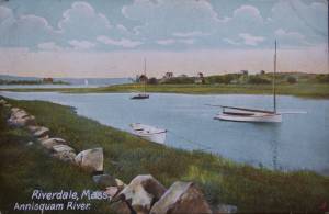
Postcard
Cape Ann Museum Library & Archive
Also filed under: Annisquam River »
From the days of the earliest English settlements on Cape Ann through Fitz Henry Lane’s lifetime, subsistence farmers harvested hay during the summer and autumn months and stored it away to feed livestock during the winter. They also sold it to others in the community for cash or bartered it for other goods and services. Two types of hay were harvested: English hay, meaning hay that was cultivated, and salt marsh hay which was cut from tidal areas where it grew naturally. Many farmers dealt in both. Hay was transported either in wagons drawn by horses or oxen, or by gundalows, flat bottom work boats which could easily maneuver in shallow marsh areas. One example of a family who engaged in haying was the Ellerys who lived at Gloucester’s old Town Green. An account book which Benjamin Ellery (1744–1825) kept is preserved in the archives of the Cape Ann Museum. It reveals that Ellery dealt in both cultivated and natural hay as well as other commodities. He also owned a gundilow, oxen and wagons, all of which he used for his own purposes and made available to others on a barter basis. The practice of haying died out on Cape Ann as automobiles and trucks came into use during the first quarter of the twentieth century and livestock disappeared from the area.
– Martha Oaks (April, 2015)
1863 Oil on canvas 22 x 36 in. Cape Ann Museum, Gloucester, Mass., Gift of Roger W. Babson, 1937 (779.02)
Detail showing a flat-bottomed gundalow loaded with marsh hay and being propelled by men with long sweeps.
Also filed under: Babson House » // Gundalow / Scow »
Emmeline (Emma) Rogers Babson (1839–1905) was born in Gloucester, Massachusetts, the eldest of the two daughters of Nathaniel Babson and Emmeline Davis (Rogers) Babson.
Her mother died when Emma was five and her father, who was a house painter by profession, a selectman, and active in the abolitionist movement, never remarried.
Emma attended the Oread Institute of higher education for women in Worcester, Massachusetts, for one year (her sister Maria attended for one term), before returning to Gloucester, where she brought income into the house as a dressmaker. She married William Hovey Friend (1840–1914) in 1869, and immediately moved to San Francisco, California, where her husband had been residing since 1863. He was a bookkeeper for several firms, and at one time represented the California branch of the Gloucester wholesale fish business of John E. Pew & Sons. In 1896, he became the postmaster of Oakland, California, where he was also trustee and deacon of the First Presbyterian Church for many years. He and Emma had two sons, William Nathaniel Friend, born in 1870 and Roger Berry Friend, born in 1873.
Emma was one of the original organizers of the Ebell Society in 1876 (formed to promote and advance the study by women of literature, science and art), and although suffering from ill health, continued an interest in its affairs until her death. She also helped to organize the Oakland Chapter of the Daughters of the American Revolution, was a member of the General Society of the Mayflower Descendants, and a life member of the YWCA. She was active in the first campaign for woman's suffrage in 1896, and when the Spanish war broke out she was instrumental in organizing the Oakland Red Cross Society, whose first meeting was held at her home. She was also an avid collector of china and wrote authoritatively about it. She wrote many other articles on a variety of subjects, including art. She died in Oakland, California, in 1905.
Lane made paintings for Emma and her sister Maria from three sketches.
Maria Rogers Babson (1840–1913) was born in Gloucester, Massachusetts, the youngest of the two daughters of Nathaniel Babson and Emmeline Davis (Rogers) Babson. She died unmarried in California at the age of seventy-three.
Her mother died when Maria was four and her father, who was a house painter by profession, a selectman, and active in the abolitionist movement, never remarried. Maria and her older sister Emma both briefly attended the Oread Institute of higher education for women in Worcester, Massachusetts—Maria for one term and Emma for one year.
Maria moved to California in 1870, following her sister who had married and moved there the previous year. In California, both sisters became active in a variety of charitable, social and religious organizations. Maria was a charter member of the Ebell Society and Club (formed to promote and advance the study by women of literature, science and art), its General Curator, and indefatigable promoter for many years. She also was prominent in the Oakland Red Cross Society and helped found the Convalescent Home during the Spanish war. She was treasurer of the fund for the children's room in the Carnegie Library and involved in the organization and perpetuation of the Oakland Chapter of the Daughters of the American Revolution. She took a significant interest in the activities, especially the missionary work, of the First Presbyterian Church, being an honorary member of the American Board and an active member of the Occidental Board of Foreign Missions. She died at the home of her nephew in San Francisco on May 1, 1914. (1)
Lane made paintings for Maria and her sister Emma from three sketches.
(1) Past and Present of Alameda County California, Vol. II (Chicago: S. J. Clarke Publishing Company, 1914) , 472-475.
Nathaniel Babson was a Gloucester merchant and a town selectman from 1847 to 1850, and again in 1860. He was a strong supporter of abolition and brought speakers into town to lecture on the subject. He was part owner of two schooners, the "Dianna" in 1855 and the "Flying Cloud" from 1855 to 1859.
According to notes on his drawings, Lane made a painting for Nathaniel Babson of Stage Rocks, and three paintings for his two daughters of their family home.
Nathaniel Babson (1810–63) married Emmeline Davis Rogers (1816–44) on January 16, 1838. He was the son of Capt. Nathaniel Babson and Eliza Gorham Low and a cousin of Edward and John James Babson, his father and their father being brothers. Emmeline was the daughter of Shubael Gorham Rogers and Mary (Davis) Rogers. They had three children: Emmeline Rogers (1839–1903) who married William Hovey Friend; Maria Rogers (1840–1913), who did not marry, and an unnamed daughter who died in the year of her birth, 1844. In the 1860 census, after his wife’s death, Nathaniel Babson was described as a [house] painter and their daughter Emmeline as a dressmaker.
Shortly before his death, ownership of Nathaniel Babson's home went to Maria and Emma's uncle, Gustavus Babson (1820-1897)
.
Stereograph card Cape Ann Museum Library & Archive
Stereo view of the house owned by Nathaniel Babson (Emma and Maria). The house was sold to Gustavus shortly before Nathaniel's death.
Also filed under: Babson House » // Historic Photographs »