An online project under the direction of the CAPE ANN MUSEUM
Riverdale Mills
View related Fitz Henry Lane catalogue entries (2) »
Although earlier mills were built on Mill River, up river in the woods, the site of the Riverdale Mills is supposedly the site of the first tide mill built in Gloucester, a sawmill erected in 1652. A second grist, or corn, mill was added in 1677. They became part of the business enterprise of Rev. John Emerson, pastor of the one church in all of Gloucester from 1663 to 1700. Emerson and his partners were most concerned with the sawmill and with cutting 20,000 board feet from common land timber—their concession from the Town. Later reconstructed versions of those two early mills can be seen in the distance in Lane's painting The Babson Meadows at Riverdale, 1863 (inv. 11) where they appear near the middle of the canvas, peaking over the left top of the solitary green-leafed tree by the stone wall.
The mills seem to have been mostly owned, in the first two centuries, by the Town, with rights to them awarded to capable managers and millers. For a while, around 1706, the mills were run by John Ring and were long known as Ring's Mills, and then as Bennett's Mills. For much of the first third of the nineteenth century, they were managed by the merchant Zachariah Stevens, uncle of Lane's good friend Joseph L. Stevens, Jr. It is not clear who the miller was during his time. Stephen Brown became the miller in 1835. When Lane painted this scene in 1863, the mills were run by Levi Brackett, Stephen Brown, and his son Edward Brown, and they were known as Brown's Mills. Grain was brought in sacks, ground and returned in sacks to the owners, the cost being mostly the miller's wages. Levi Brackett who lived at 372 Washington Street (to the left of the view in Lane's Babson Meadows) and Stephen Brown's son Edward H. Brown ran the mill until after Lane's death.
Brackett retired in 1875 and the mills were sold to Albert Dodge, who owned them into the twentieth century and had two turbine wheels installed which were turned by the out-flowing of the stored-up mill pond water, a source of power that lasted for 12 to 15 hours a day. The mills were torn down in 1926, but an old millstone, presumably from the grist mill, lies near the Richdale's market at 410 Washington Street.
Current location: on causeway over Mill River, between 400 and 410 Washington Street (Rte. 127).
– Sarah Dunlap (November, 2013)
Cape Ann Museum Library & Archive
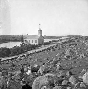
Riverdale Methodist Church on Washington Street above the Mills. Mill River and Wheeler's Point to left rear distant background Annisquam Point.
Also filed under: Riverdale Methodist Church (Washington Street) »
1823 Cape Ann Museum Library & Archive Grayscale version of color original
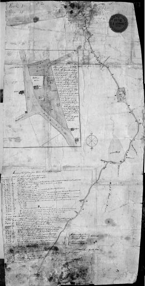
Map of Riverdale from the Mills to the Whittemore House at Middle and Washington Streeets ordered by a committee of selectmen, William Pearce, Samuel Stevens, Daniel H. Rogers with John Mason and Anthony Presson. Map drawn by surveyor William Saville and present to the committee in June, 1823. It contains a enlarged view of The Green, including the Ellery and Babson houses painted by Lane.
Also filed under: Babson House » // Low (David) House » // Maps » // Meetinghouse Green » // Riverdale / Town Parish »