An online project under the direction of the CAPE ANN MUSEUM
Dale, Eben B.
Eben B. Dale purchased the house named Steepbank around 1858. Steepbank was near Fresh Water Cove which, in Lane's time, served as a summer estate for brothers Eben and Theron Dale. Two of Lane's drawings, Gloucester from Steepbank and Across Gloucester Outer Harbor from Steepbank, were made there.
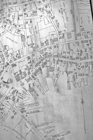
The location of Eben Dale's house on Middle Street can be seen on the map attached.
Related tables: Steepbank »
24 x 38 in.
Gloucester City Archives
"Drawn on a scale of one hundred feet to an inch. By John Mason 1834–45 from Actual Survey showing every Lott and building then standing on them giving the actual size of the buildings and width of the streets from the Canal to the head of the Harbour & part of Eastern point as farr as Smith's Cove and the Shore of the same with all the wharfs then in use. Gloucester Harbor 1834–35."
This map is especially helpful in showing the wharves of the inner harbor at the foot of Washington Street.
View related Fitz Henry Lane catalog entries (1) »
Also filed under: Eastern Railroad » // Flake Yard » // Gloucester Harbor, Inner / Harbor Cove » // Hough, Benjamin Kent » // Maps » // Pavilion (Publick) Beach » // Ropewalk » // Sawyer, Samuel » // Town / Public Landings » // Universalist Church (Middle and Church Streets) »
