An online project under the direction of the CAPE ANN MUSEUM
Catalogue Entry
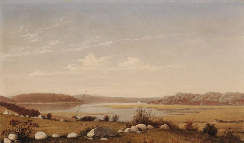
This exquisite painting is quite small, yet it captures an expansive landscape in great detail. The view is looking west up the Annisquam River from a spot referred to as "Done Fudging." The present-day site is the Grant Circle traffic rotary on Massachusetts Route 128, just as one comes off the bridge over the Annisquam River and onto Cape Ann.
"Fudging" is a local term specific to river craft and refers to the upstream poling that was often necessary in the narrow river because of unfavorable wind or tidal flow. Lane drew and painted a number of pictures from this spot, where one could stop the laborious poling and be "done fudging." It must have been relatively easy for him to get here from the harbor by carriage—one of his early residences was only a half mile or so away. In contrast to the constant bustle of the harbor, Done Fudging was a peaceful and verdant place.
The upland field, rocks, and shrubs in the foreground, painted in sharp detail, give onto the flat monochrome of the salt marshes and the silvery-green hills of Wolf Island (on the right) and those behind Little River (on the left). Though this is unusual for Lane, the landscape is almost empty except for the small sloop pulled up on the shore, the ruin of a gundalow (used for hauling salt hay, and propelled by poling) on the right edge, and the small, distant sail. Otherwise, this is a tonal study of a beautiful Indian-summer day in late September or early October when the marshes have started turning gold, and trees and shrubs are showing a hint of red.
For all its seeming simplicity, Looking up Squam River from Done Fudging is a strong composition. Lane leads the eye in from the lower left, following the stones diagonally to the gundalow before returning to the left and following the river course and marsh edge. The direction then reverses to the right and takes the viewer's eye onto the brightly lit river, to the sail in the distance, and on around the corner of the land form. This Z-shaped composition, commonly used by Lane, leads the eye effortlessly through the picture and up the river, creating a balanced and open-ended feeling of space and distance.
There are relatively few Lanes with so little anecdotal detail; one wonders if this painting might have been influenced by the salt-marsh paintings of Martin Johnson Heade. Heade painted in the marshes north of Gloucester in Newbury and Newburyport from the late 1850s through the 1860s. His paintings are often devoid of human activity, and they lead the viewer through the deep space of the salt marsh by following the meanderings of the channels and hay stacks that recede into the distance.
The drawing for this painting is Westward View from near East End of Railroad Bridge, Mid 1850s (inv. 118). It is gridded vertically for transfer onto a canvas. Note where Lane, in order to complete the symmetry of the grid, extended the left edge of the painting beyond the point where the drawing stopped. Lane did a number of other paintings from this spot, most notably New England Inlet with Self-Portrait, 1848 (inv. 77). That painting shows the artist drawing, with his crutches beside him, and is one of only a few paintings we know of with an apparent self-portrait. Another emphasis of that painting is the railroad trestle on the left with a train shown heading into Gloucester. (The railroad had newly arrived to Gloucester in 1848.) This painting, by contrast, shows the embankment of the railroad on the left but no train to disturb the tranquility of the setting.
– Sam Holdsworth
- Subject Types
: - Seasons / Weather
: - Autumn »
- Vessel Types
: - Cape Ann Locales
: - Activities of People
:
Historical Materials
Newspaper clipping
Cape Ann Advertiser
Collection of Fred and Stephanie Buck
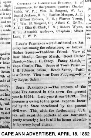
"LANE'S PAINTINGS were distributed on Saturday last among the subscribers, as follows: Harbor Scene, – Thaddeus Friend. View of Bear Island, – George Marsh. Good Harbor Beach, – Mrs. J. H. Stacy. Fancy Sketch, – Capt. Charles Fitz. Scene at Town Parish, – J. H. Johnson, Salem. Beach Scene, – Pattillo & Center. View near Done Fudging, – Ripley Ropes, Salem."
Filed under: Alex Patillo Dry Goods » // Baptist Church (Old, First, 1830) (Pleasant Street) » // Center & Co. » // Center, Henry » // Done Fudging » // Fitz, Capt. Charles » // Friend, Thaddeus » // Johnson, J. H. » // Marsh, George » // Newspaper / Journal Articles » // Patillo, Alex » // Ropes, Ripley » // Stacy, Mr. and Mrs. John Hancock »
Digital photograph
Martha Oaks
View related catalogue entries (2) »
Filed under: Done Fudging » // Site Photographs »
Technically not a river but a saltwater tidal estuary, the Annisquam (or "Squam") River almost cuts off Cape Ann from the rest of the world. Its constantly flowing tides, and the gleaming expanse of marshes surrounding it, inspired several of Lane's paintings. Marsh hay was harvested along its tidal inlets and provided subject matter for Lane's depiction of this ancient occupation, and the traditional craft associated with it, the gundalow. The Annisquam is connected to Gloucester Harbor by The Cut, also known as the Blynman Canal, which was first dug in the seventeenth century, filled in and opened again to complete the more direct inland passage between the harbor and open ocean.
4 x 5 in.
Cape Ann Museum Library & Archive
#10159
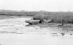
Rare view of a marsh gundalow, being used on the Annisquam River for harvesting salt marsh hay.
Also filed under: Gundalow / Scow »
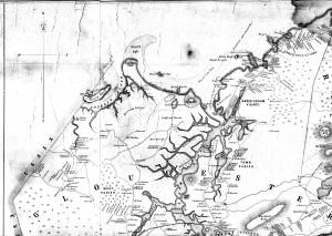
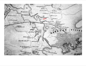
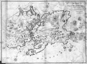
1851 44 x 34 in. Henry Francis Walling, Map of the Towns of Gloucester and Rockport, Essex Co. Massachusetts. Philadelphia, A. Kollner, 1851 Cape Ann Museum Library & Archive
"Map of the Towns of Gloucester and Rockport, Massachusetts. H.F. Walling, Civil Engineer. John Hanson, Publisher. 1851. Population of Gloucester in 1850 7,805. Population of Rockport in 1850 3,213."
Also filed under: Babson House » // Coffin's Beach » // Eastern Railroad » // Gloucester, Mass. – Annisquam Harbor Lighthouse » // Granite Quarrying / Shipping » // Loaf, The » // Low (David) House » // Maps » // Old First Parish / Subsequent Fourth Parish Church (at the Green) » // Riverdale Methodist Church (Washington Street) » // White-Ellery House »
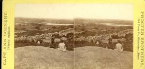
1870s Stereograph card Cape Ann Museum Library & Archive
Also filed under: Historic Photographs »

44 x 34 in.
Henry Francis Walling, Map of the Towns of Gloucester and Rockport, Essex Co. Massachusetts. Philadelphia, A. Kollner, 1851
Cape Ann Museum Library & Archive
"Map of the Towns of Gloucester and Rockport, Massachusetts. H.F. Walling, Civil Engineer. John Hanson, Publisher. 1851. Population of Gloucester in 1850: 7,805. Population of Rockport in 1850: 3,213."
Also filed under: Brookbank » // Dolliver's Neck » // Fresh Water Cove » // Gloucester Harbor, Outer » // Maps » // Norman's Woe » // Stage Rocks / Stage Fort / Stage Head » // Steepbank » // West Gloucester – Little River » // Western Shore »
Also filed under: Davis' Neck »
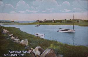
Postcard
Cape Ann Museum Library & Archive
Also filed under: Riverdale / Town Parish »
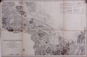
Survey of the Coast of the United States, Washington, D.C.
Collection of Erik Ronnberg
Also filed under: Maps »
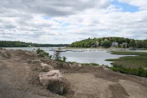
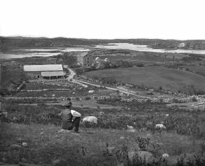
Done Fudging (or "Done Fudgin'" or "Dunfudgin'") refers to an area along the Annisquam River, just west of the old Meetinghouse Green. It is now the heavily trafficked site of Grant’s Circle, the first rotary in Gloucester after crossing the Route 128 bridge. It was an area central to transportation in Lane’s time, as it is now. Washington Street came to it from the harbor, traversed the Green, and headed north to Riverdale and Annisquam. The train tracks from Boston crossed the Annisquam River at this point after running along the side of the river, initially on a trestle and later on an earth embankment still in use today. There was a town landing for boats that landed all manner of goods and people moving up and down from Annisquam and Ipswich Bay or crossing onto Cape Ann from West Gloucester.
The name refers to the poling of river craft often necessary in the narrow river because of unfavorable wind or tidal flow. It’s a muddy bottom all along the Annisquam River, and poling a boat was called "fudgin'." There is a strong tidal current coming from both directions, from the south and Gloucester Harbor through the Cut and down the river from Ipswich Bay to the north. The tidal flows meet at Done Fudging. If you were “fudgin'” south against the tide draining into Ipswich Bay, when you reached the area of Done Fudging, the draining tide would change direction and carry you effortlessly out to Gloucester Harbor. Or vice versa, either way when you reached that point you were “done fudgin'." The river also broadens out at this point so at a full tide with a decent wind, sails could be raised and the fudgin’ poles put away, at least for a while.
Lane drew and painted a number of pictures from this spot. It must have been relatively easy for him to get there by carriage from the harbor. One of his early residences, Whittemore House on Washington Street, was only a half mile or so away. In contrast to the constant bustle of the harbor, Done Fudging was a peaceful and verdant place. The small farms with their trees and meadows stretched along both sides of Washington Street, while the salt marsh running along the Annisquam River went from emerald green in summer to gold in fall and brown in winter.
Lane did several views looking west upriver from Done Fudging, such as Looking up Squam River from Done Fudging, 1850s (inv. 26). The two most intriguing are nearly identical and include apparent self portraits of the artist (one with crutches, one without) sitting on a rock and drawing the river scene in the company of several large cows (see New England Inlet with Self-Portrait, 1848 (inv. 77)).
Today, the public landing at Done Fudging is one of the City of Gloucester’s most popular and heavily used public landings. It is located adjacent to Gloucester High School and has a small boat launching ramp which is accessed by a paved road.
Newspaper clipping
Cape Ann Advertiser
Collection of Fred and Stephanie Buck
"LANE'S PAINTINGS were distributed on Saturday last among the subscribers, as follows: Harbor Scene, – Thaddeus Friend. View of Bear Island, – George Marsh. Good Harbor Beach, – Mrs. J. H. Stacy. Fancy Sketch, – Capt. Charles Fitz. Scene at Town Parish, – J. H. Johnson, Salem. Beach Scene, – Pattillo & Center. View near Done Fudging, – Ripley Ropes, Salem."
Also filed under: Alex Patillo Dry Goods » // Baptist Church (Old, First, 1830) (Pleasant Street) » // Center & Co. » // Center, Henry » // Fitz, Capt. Charles » // Friend, Thaddeus » // Johnson, J. H. » // Marsh, George » // Newspaper / Journal Articles » // Patillo, Alex » // Ropes, Ripley » // Stacy, Mr. and Mrs. John Hancock »
Digital photograph
Martha Oaks
View related catalogue entries (2) »
Also filed under: Site Photographs »
Gloucester’s First Parish was started here in 1641 when Pastor Blynman and his dissident group left the Plymouth Colony to start anew on Cape Ann. They were focused on agriculture, not fishing, and chose this relatively flat area of Cape Ann for its soil, fresh water, and relative protection from the sea weather to start their colony and build their first church. It was another fifty years before fishing began in earnest and the population gradually moved to the harbor area. This left Meetinghouse Green as a quiet pocket of small farms and tidal mills seemingly worlds away from the bustling harbor.
The Green, as it was commonly called, was located between the Annisquam River at Done Fudging and the head of the tidal Mill River to the north. The first meetinghouse on Cape Ann was built there in the 1640s, replaced by a successor built in 1752 which lasted until the 1840s when it was taken down for lack of funds and parishioners. The southern side of the Green is now almost completely obliterated by the Grant Circle rotary just over the Route 128 bridge as it comes onto Cape Ann. The northern side of the Green was up Washington St. from the rotary and occupied the present site of Addison Gilbert Hospital and the neighborhoods around it. The only structure left from the days when The Green was the town center is the Ellery House, which is now on the east side of Washington Street. This house is now owned by the Cape Ann Museum.
In Lane’s day there was a public landing on the Annisquam River at Done Fudging where the rotary now sits. Washington Street came north from the harbor and followed its present day route up the hill between the Babson house and Ellery house (moved to the east side of the street in 1953) and onto the Green. It was a quiet rural area in Lane’s time in contrast to the intense activity and swelling population of the harbor town.
Lane painted a number of pictures of this area, starting in the late 1840s with several self portraits of him painting in the landscape looking west from Done Fudging up the Annisquam River. Nowhere is the serene nature of this area better expressed than in two of Lane’s late views, Babson and Ellery Houses, Gloucester, 1863 (inv. 10) and The Babson Meadows at Riverdale, 1863 (inv. 11). The former shows the town landing at Done Fudging with a pole barge full of salt hay and the two prominent old houses flanking Washington Street. The view in Riverdale is taken from the north edge of The Green and looks up Mill River towards Riverdale in the distance.
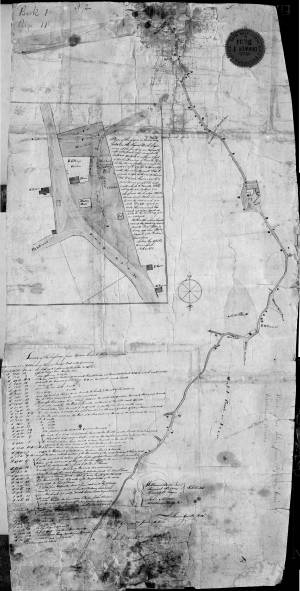
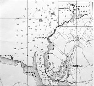
1823 Cape Ann Museum Library & Archive Grayscale version of color original
Map of Riverdale from the Mills to the Whittemore House at Middle and Washington Streeets ordered by a committee of selectmen, William Pearce, Samuel Stevens, Daniel H. Rogers with John Mason and Anthony Presson. Map drawn by surveyor William Saville and present to the committee in June, 1823. It contains a enlarged view of The Green, including the Ellery and Babson houses painted by Lane.
Also filed under: Babson House » // Low (David) House » // Maps » // Riverdale / Town Parish » // Riverdale Mills »
Lithograph
28.5 x 21 in.
Cape Ann Museum Library & Archive
When Massachusetts decreed that each town be mapped, John Mason drew the map of Cape Ann in 1830. This drawing was sent to the Senefelder Lithographic Company of Boston (owned by William Pendleton) to be printed, and then sold in Gloucester by W.E.P. Rogers, whose Gloucester Telegraph of February 12, 1831 announced, "A few specimen copies of the map, uncolored, have reached the town" and that they cost $1.25. Perhaps this business arrangement between Pendleton and Rogers provided Lane with his introduction to Pendleton.
Also filed under: Folly Cove » // Good Harbor Beach / Bass Rocks » // Maps » // Mason, John » // Pendleton's, Lith. – Boston » // Salt Island » // Thacher Island »
Riverdale is one of Gloucester’s many neighborhoods. Although its boundaries have never been formally set, it runs from the historic Town Green north around the shores of the Mill River. Dogtown is upland and Wheeler’s Point is to the west. Landmarks in the neighborhood over the years have included a dam built across the upper end of the Mill River; a corn mill which ran off tidal waters that flowed out of a pond created by the dam; Poles Hill, a huge granite outcropping at the intersection of what are now Wheeler and Washington Streets; a Methodist meeting house; and the original Town Green. A history of the neighborhood, privately printed in 1950 and available in the archives of the Cape Ann Museum, has this to say about the derivation of the name Riverdale:
"This section of the town (of Gloucester) has long borne the name 'Riverdale,' said to have been given it in 1859 by Lodowick H. Bradford, a Boston man who married into the Brown family which then owned the mills. The name does not appear in Babson’s History; he alludes to the section as the 'old town.' It kept its purely Yankee population and character longer than most other parts of the city."
– Martha Oaks (2015)
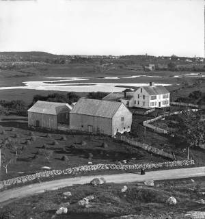
c.1869 Stereograph card Cape Ann Museum Library & Archive
View of the Babson Farm taken from Pole's Hill, showing the old Murray Meeting House (rear section of barn), fields and Mill River. In the background is the skyline of the major buildings at Harbor Village, including the first version of City Hall destroyed by fire in 1869.
Also filed under: Babson House » // Universalist (Original) Meeting House (Sargent) »
1823 Cape Ann Museum Library & Archive Grayscale version of color original
Map of Riverdale from the Mills to the Whittemore House at Middle and Washington Streeets ordered by a committee of selectmen, William Pearce, Samuel Stevens, Daniel H. Rogers with John Mason and Anthony Presson. Map drawn by surveyor William Saville and present to the committee in June, 1823. It contains a enlarged view of The Green, including the Ellery and Babson houses painted by Lane.
Also filed under: Babson House » // Low (David) House » // Maps » // Meetinghouse Green » // Riverdale Mills »
Postcard
Cape Ann Museum Library & Archive
Also filed under: Annisquam River »
Wolf Hill was notable as a granite quarry, however the quality of the stone was unreliable. After the first City Hall which was built from Wolf Hill stone in 1869, burned and crumbled, there were warnings not to use stone from that location to rebuild it.
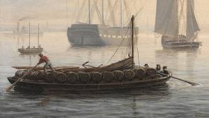
The rivers of northern New England gave rise to a type of freighting scow called a "gundalow," having square ends, a flat bottom, shallow draft, and sturdy construction going beyond the usual standards for this hull type. The term “gundalow”—variously spelled and pronounced—was first used in the late seventeenth century in New England, and was derived from the Old World term “gondola”—also a flat-bottom vessel, but more varied in hull form and uses. (1)
The rivers and estuaries of Essex County, Massachusetts were subject to tidal variations and their surrounding lowlands were salt marshes which yielded prodigious quantities of grass. The more succulent varieties, called “marsh hay” were valued fodder for livestock, while “thatch,” which grew along the tidal creeks, was used for roofing of buildings, bedding for livestock, and compost for gardens. Grasses on higher elevations could be carted away after cutting, but at lower elevations, it was the job of gundalows to bring it to a landing for distribution. Gundalows for these tasks were relatively small, less than 40 feet in length, propelled by long oars called “sweeps,” and by poles. Occasionally a single square sail was set from a short mast if the landing was distant and downwind. (2)
Larger gundalows, of more elaborate construction, were to be found on the Merrimac and Piscataqua Rivers of Northern Massachusetts and the Maine–New Hampshire boundary, respectively. The Merrimac gundalows probably reached 45–50 feet in length, had long overhangs with a stem post, a skeg with rudder and tiller, heavy framing, and a mast stepped well forward from which a square sail could be set when going downwind. (3)
Not just confined to the Merrimac River, many of these vessels found their ways to the Ipswich marshes via a canal on the mainland side of Plum Island. Smaller and simpler versions of this type were built to work in the salt marshes of Essex and West Gloucester, dispensing with sails and propelled much of the time by poling through narrow tidal creeks. (4)
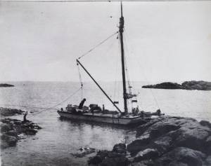
Lane took notice of a gundalow in his painting Babson and Ellery Houses, Gloucester, 1863 (inv. 10) and the remains of another in his Looking up Squam River from Done Fudging, 1850s (inv. 26). In both cases, the hulls are small and simple in detail, but the latter shows part of its heavy inboard construction. Gundalows of this variety survived in Cape Ann estuaries long enough to be photographed.
Piscataqua River gundalows were the largest and most highly developed of this vessel type, measuring 65 feet or more and rigged with a lateen sail set on a very short mast. When sailing under a bridge, the sail could be dipped without lowering and quickly reset once clear. The hull was modeled with a rounded bow and finely shaped stern; many were fitted with a leeboard so the vessel could sail upwind on the broader reaches of the Piscataqua. (5)
Lane’s depiction of a gundalow in Boston Harbor in the mid-1840s is of the type associated with the Piscataqua River, but having features of both earlier and later examples, together with a rig not known to be used on these craft. The “spoon bow” has generally been regarded as a post-1860 feature, yet Lane’s example has one. The stern has a finely modeled transom which is clearly seen in the underdrawing revealed by infrared scanning. Rudders were supposed to be fitted by the early 1800s, but Lane’s example is steered with an oar. The graceful sheer is another feature considered to post-date Lane’s painting. Finally, the rig consists of a gaff- headed sail set from a very short mast. Short fixed masts setting large lateen sails were common to late gundalows, but the gaff rig depicted is so small that its usefulness is limited if not questionable (6).
Close examination of the infrared scans of this image shows careful drafting of the hull and re-drawing of the crew, sweeps, and steering oar. The cargo of casks is also extensively redrawn to show correct stowage. Whether the changes were due to criticisms from others or the artist’s own evaluation is probably lost to history.
– Erik Ronnberg
References:
1. M.H. Parry et al., Aak to Zumbra: The World's Watercraft, (Newport News, VA: The Mariners' Museum, 2000), 264.
2. Ibid.; and Nancy V. Weare, Plum Island: The Way It Was, 2nd ed. (Newbury, MA: Newburyport Press, Inc., 1996), 43–48.
3. D. Foster Taylor, "The Piscataqua River Gundalow," The American Neptune II, no. 2 (April 1942): 127–39.
4. Weare, 43–48.
5. Taylor, 127–39.
6. Ibid.; and author's observations.
4 x 5 in.
Cape Ann Museum Library & Archive
#10159
Rare view of a marsh gundalow, being used on the Annisquam River for harvesting salt marsh hay.
Also filed under: Annisquam River »
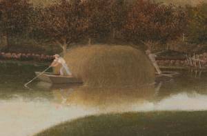
1863 Oil on canvas 22 x 36 in. Cape Ann Museum, Gloucester, Mass., Gift of Roger W. Babson, 1937 (779.02)
Detail showing a flat-bottomed gundalow loaded with marsh hay and being propelled by men with long sweeps.
Also filed under: Babson House » // Salt Marsh Hay / English Hay »
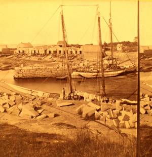
Stereograph
Cape Ann Museum Library & Archive
Also filed under: Granite Quarrying / Shipping »
Photograph
Private collection
Granite scow being unloaded at Knowlton's Point, Sandy Bay. Sandy Bay Ledge visible in right background, Dodge's Rock in left background.
Also filed under: Granite Quarrying / Shipping »
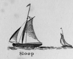
Sloops are one-masted sailing vessels which, in American examples, set fore-and-aft sails but usually no square sails. Thus, staysails, or jibs, are set from the fore stay(s) and a quadrilateral mainsail is set from the mast and spread by a gaff and a boom. The larger sloops would often set a triangular topsail over the main sail. (1)
The sloops depicted by Lane were used in various coastal trades, each with its own requirements, which dictated the sizes and details of their hulls and rigs. Most elegant were the packet sloops, which transported passengers, mail, and higher value goods between specific ports on regular schedules. They usually measured between sixty and seventy-five feet on deck, as dictated by anticipated shipping volume. Finely finished, they usually had stern galleries—a row of windows across the transom with ornamental moldings—and varied color schemes. Examples of packet sloops are in Gloucester Harbor from Rocky Neck, 1844 (inv. 14) (center, middle ground) and Study of Ships, 1851 (inv. 141) (foreground), both of which probably made trips between Gloucester and Boston, or Gloucester and Newburyport. (2)
Another specialized sloop of similar size was the stone sloop, used to ship granite blocks from stone-loading piers around Cape Ann to other ports. They were similar in rig to packet sloops, but of heavier construction with greater hold capacity and absence of decoration. Their stout appearance was augmented by simple color schemes, or even tarred topsides, reflecting the wear and strain imposed by their heavy cargos. Lane depicted these vessels in his painting of Fresh Water Cove from Dolliver's Neck, Gloucester, Early 1850s (inv. 45), with a sloop (at left) preparing to load at wharf-side, and another (at right) sailing out with a cargo. (3)
Sloops of the more work-a-day sort are the most commonly seen examples in Lane’s paintings, most of them appearing in his views of Boston Harbor. Usually deep-loaded and looking weather-worn, they contrast sharply with the packet- and clipper ships which dominate the scene. Sloops of this type are rarely seen in Lane’s paintings of Gloucester Harbor and the Maine coast, although they were certainly needed for short-distance transportation (see Bear Island, Northeast Harbor, 1855 (inv. 24), View of Camden Mountains from Penobscot Bay, c.1852 (inv. 207), Sunrise on the Maine Coast, Mount Desert Island, 1856 (inv. 295)). For coastal Maine, lack of railroads for heavier freight and greater distances between ports made the use of schooners with larger carrying capacity a greater necessity. (4)
In Lane’s views of New York Harbor, a regional sloop variant, the Hudson River Sloop, appears in New York Harbor, c.1855 (inv. 46) (bow view, left) and A Calm Sea, c.1860 (inv. 6) (stern view, right). This type had become prominent in the Hudson River packet trade between New York City, Albany, and beyond to points north and west as far as the eastern terminus of the Erie Canal. Large vessels for their rigs, they were well-finished and well-kept, reflecting pride of ownership and rivalry among their owners and crews. (5)
– Erik Ronnberg
References:
1. A Naval Encyclopaedia (Philadelphia: L.R. Hamersly & Co., 1884. Reprint: Detroit, MI: Gale Research Company, 1971), 59. See first definition of "sloop" and definition of "sloop-rigged."
2. Robert Greenhalgh Albion, William A. Baker, and Benjamin Woods Labaree, New England and the Sea (Mystic, CT: Mystic Seaport Museum, 1972; reprinted in 1994), 127–28.
3. Howard I. Chapelle, The History of American Sailing Ships (New York: W.W. Norton & Co., 1935), 300–02.
4. Ibid., 300.
5. Ibid., 298–300.
A Naval Encyclopaedia:
Dictionary of nautical words and phrases
Special Articles on Naval Art and Science
Philadelphia: L.R. Hamersly & Co.
'Mudian, "Mugian, or Bermudian. A boat special to the Bermuda islands, usually decked, with the exception of a hatch; from 2 to 20 tons burden; it is short, of good beam, and great draft of water abaft, the stem and keel forming a curved line. It carries an immense quantity of ballast. Besides a long main- and short jib-boom, it has a long, taperking, raking mast, stepped just over the forefoot, generally unsupported by shrouds or stays; on it a jib-headed mainsail is hoisted to a height of twice, and sometimes three times, the length of the keel. This sail is triangular, stretched at its foot by a long boom. The only other sail is a small foresail or jib. They claim to be the fastest craft in the world for working to windward in smooth water, it being recorded of one that she made five miles dead to windward in the hour during a race; and though they may be laid over until they fill with water, they will not capsize.
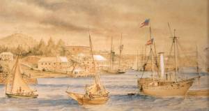
St. George's Historical Society
Detail of painting of St. George's Harbour, Bermuda, during US Civil War, with a Confederate blockade runner anchored in the foreground.
Also filed under: Puerto Rico »
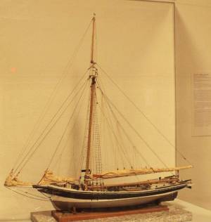
Wood, metal, cordage, cloth, paint.
Scale: ¼ in. = 1ft. (1:48)
Cape Ann Museum. Gift of Roland and Martta Blanchet (1997.17.3)
Although built in 1890 and larger than the stone sloops of Lane’s time, the "Albert Baldwin’s" hull form, rig, and loading boom are very similar to those of the 1840s and 1850s.
Also filed under: Granite Quarrying / Shipping » // Ship Models »

From the days of the earliest English settlements on Cape Ann through Fitz Henry Lane’s lifetime, subsistence farmers harvested hay during the summer and autumn months and stored it away to feed livestock during the winter. They also sold it to others in the community for cash or bartered it for other goods and services. Two types of hay were harvested: English hay, meaning hay that was cultivated, and salt marsh hay which was cut from tidal areas where it grew naturally. Many farmers dealt in both. Hay was transported either in wagons drawn by horses or oxen, or by gundalows, flat bottom work boats which could easily maneuver in shallow marsh areas. One example of a family who engaged in haying was the Ellerys who lived at Gloucester’s old Town Green. An account book which Benjamin Ellery (1744–1825) kept is preserved in the archives of the Cape Ann Museum. It reveals that Ellery dealt in both cultivated and natural hay as well as other commodities. He also owned a gundilow, oxen and wagons, all of which he used for his own purposes and made available to others on a barter basis. The practice of haying died out on Cape Ann as automobiles and trucks came into use during the first quarter of the twentieth century and livestock disappeared from the area.
– Martha Oaks (April, 2015)
1863 Oil on canvas 22 x 36 in. Cape Ann Museum, Gloucester, Mass., Gift of Roger W. Babson, 1937 (779.02)
Detail showing a flat-bottomed gundalow loaded with marsh hay and being propelled by men with long sweeps.
Also filed under: Babson House » // Gundalow / Scow »
In 1859 William Parsons II was listed as a winner of "a winter scene, giving a representation of cutting vessels out of the ice" at the lottery held at Procter Brothers.
In her account, Sharon Worley notes that two paintings now at the Cape Ann Museum, (Looking up Squam River from Done Fudging, 1850s (inv. 26)) and a painting by Mary Blood Mellen, were found in the house of William Parsons II at 61 Middle Street by his great-granddaughter, who donated them to the Museum.
According to Mary Sibbalds in her book Descendants of Jeffrey Parsons of Gloucester, 2006, “William was a senior member of the firm William Parsons II & Co. which did extensive business in fish and salt in East Gloucester. The company had thirteen vessels engaged in the Banks fisheries. They were also a leading salt importing business … up and down the coast.”
His obituary states that he was a director of the Cape Ann National Bank (for 23 years), of the Gloucester Mutual Fishing Insurance Co., of the Board of Trade and a director and one of the founders of the Seamen’s Widows’ and Orphans’ Aid Society. He was also a trustee of the Cape Ann Savings Bank for 11 years and President of the Gloucester Salt Co.
In the List of Vessels belonging to the District of Gloucester, 1869 - 1909, Procter Bros., three schooners are listed as belonging to Wiliam Parsons II. It appears that he owned them jointly with his brothers and half-brothers.
William Parsons was born 8/20/1815 in Gloucester to Benjamin Parsons and Susan Coas. He was married twice, First on 5/1/1841 to Martha A. H. Friend (1819-1851) and second on 6/15/1852 to Mary Elisa Somes (1814-1898). He died on 10/1/1882 in Gloucester aged 67.
– Stephanie Buck
9.21.1859 Newspaper Gloucester Telegraph, p. 2, col. 3 Boston Public Library Accession # G587
"DRAWING OF PAINTINGS.– The distribution of five oil paintings among the subscribers to Lane’s view of Gloucester, took place on Saturday Evening, at the store of Messrs. Procter Brothers. No. 125 took the first picture, being the original painting from which the view of Gloucester was engraved. It is a valuable picture, and Mr. John H. Whidden was the lucky holder of the number. The second picture, a winter scene, giving a representation of cutting vessels out of the ice, fell to No. 186, the holder of which was Mr. William Parsons, 2d. The third picture, a moonlight scene, was taken by No. 263, which was held by Mr. Joseph Richardson of Boston. The fourth, a landscape view, fell to No. 2, the owner of which was Mr. Solomon Pool. No. 93 took the fifth, a view of a large boulder, and Mr. William D. Winchester held the ticket."
9.23.1859 Newspaper
Distribution of Oil Paintings to Subscribers of "Lane's View of Gloucester."
#125- 1st Prize of the original painting to J.H. Whidden
#186- 2nd Prize, Winter Scene, cutting vessels out of the ice. Wm. Parsons, 2nd
#263- 3rd Prize, Moonlight Scene, Joseph Richardson
#2- 4th Prize, a beautiful landscape view, Solomon Pool
#93- 5th Prize, view of a Large Bowlder. Wm. D. Winchester
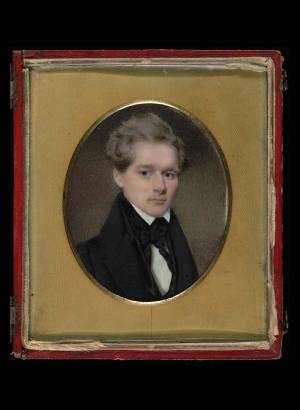
watercolor on ivory sight 2 3/4 x 2 1/4 in. (7.0 x 5.7 cm) Smithsonian American Art Museum, Museum purchase through the Catherine Walden Myer Fund (1957.11.3)
Link to Smithsonian site.