An online project under the direction of the CAPE ANN MUSEUM
Catalogue Entry
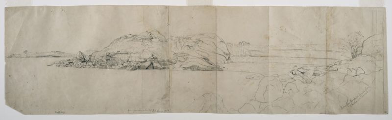
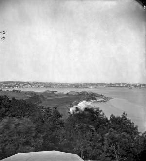
Lane painted and drew a large number of pictures of the area around Stage Rocks. Some of these, like Stage Rocks and the Western Shore of Gloucester Outer Harbor, 1857 (inv. 8), are views taken from a boat, looking back at the shore. This drawing shows a different view, one taken from Stage Rocks, looking at Half Moon Beach, the house Steepbank on the hill beyond, and the Lone Pine, a contemporary landmark on the end of Dolliver's Neck.
The inscription on the drawing appears to be in two hands: that of Joseph Stevens, who annotated many of Lane's drawings after his death, and Lane's own hand. Stevens's notes state that there was a painting made after this drawing for Nathaniel Babson, of the family for whom Lane made many paintings. The second notation, perhaps in Lane's own hand, states only "Mackay," perhaps indicating that a painting was made for Captain Mackay, a Gloucester resident who, with his wife, was known to have purchased other pictures by Lane. The location of the painting after this drawing is unknown.
- Subject Types
: - Landscape Types
: - Cape Ann Locales
:
Historical Materials
Steepbank (sometimes spelled "Steep Bank") was a house near Fresh Water Cove which, in Lane's time, served as a summer estate for brothers, Eben and Theron Dale. It had been built for “an artist” named “Mr. Eddy” in 1845, was next owned by a “Mr. Homer,” and then by a “Mr. C. B. Fessenden." Around 1858 it was purchased by Eben Dale.
Commonwealth of Massachusetts: Southern Essex District Registry of Deeds
1543 plan 0141_0002
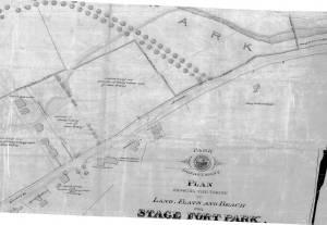
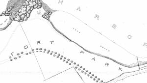
The third of the three plans has the references on it. "Plan showing the taking of land, flats and beach for Stage Fort Park…1898..."
Includes a reference to the home of Mary Turnbull which is Steepbank.
Also filed under: Maps » // Stage Rocks / Stage Fort / Stage Head »
c.1870 Stereograph card Cape Ann Museum Library & Archive
Also filed under: Gloucester – City Views » // Half Moon Beach » // Historic Photographs » // Stage Rocks / Stage Fort / Stage Head »
Newsprint
From bound volume owned by publisher Francis Procter
Collection of Fred and Stephanie Buck
"We visited the studio of Mr. Fitz H. Lane a few days since, and were much pleased in examining some fine paintings from the pencil of this talented artist. Among the collection was a view of Long Beach, in this town, with which we were particularly interested.
The scene is taken immediately after a storm. The waves with their snowy crests are rolling in upon the beach, breaking against the sides of a vessel which has been driven ashore. In the background is seen the residence of Mr. Fessenden, and the surrounding scenery; on the right are visible the high headlands near the residence of Mr. Geo. Hovey, while stretching far away in the distance may be seen Fresh Water Cove, Dolliver's Neck, and the Old Pine Tree, the whole forming a beautiful picture and true to Nature.
Several other paintings were in process of completion, one a beautiful sunset scene, which was really beautiful to gaze upon; also a view of a gale at sea, with a gallant ship plunging madly through the waves, forming a striking contrast to the mild placid scene of the picture at its side.
Mr. Lane's paintings are true to nature, and in viewing them one can but admire the skill and genius of this talented artist, We advise all lovers of the art, who wish to spend an hour pleasantly, to visit the studio of Mr. Lane on Locust St. We can assure them that they will come away highly gratified, and have an earnest desire to call again." (1)
(1) See p. 2, column 3, Courtesy of the American Antiquarian Society
Also filed under: Chronology » // Dolliver's Neck » // Fessenden, C. B. » // Fresh Water Cove » // Lone Pine » // Newspaper / Journal Articles » // Studio Descriptions »

44 x 34 in.
Henry Francis Walling, Map of the Towns of Gloucester and Rockport, Essex Co. Massachusetts. Philadelphia, A. Kollner, 1851
Cape Ann Museum Library & Archive
"Map of the Towns of Gloucester and Rockport, Massachusetts. H.F. Walling, Civil Engineer. John Hanson, Publisher. 1851. Population of Gloucester in 1850: 7,805. Population of Rockport in 1850: 3,213."
Also filed under: Annisquam River » // Brookbank » // Dolliver's Neck » // Fresh Water Cove » // Gloucester Harbor, Outer » // Maps » // Norman's Woe » // Stage Rocks / Stage Fort / Stage Head » // West Gloucester – Little River » // Western Shore »
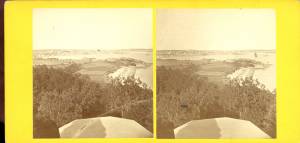
c.1860 Stereograph card Cape Ann Museum Library & Archive
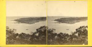
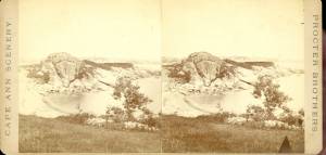
Taken from Steepbank, on the western side of Gloucester Harbor, and showing a small boat at anchor in the cove, then the Neck, and the sea beyond.
Also filed under: Dolliver's Neck » // Fresh Water Cove » // Historic Photographs » // Lone Pine »
Letter
Cape Ann Museum Library & Archive, Gloucester, Mass.
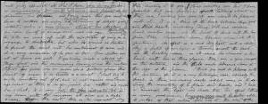
". . . will fully appreciate all that I have done in my garden, in ornamenting it, with flowers and plants, Rustic Arbours and Statues, and I only wish that you could be here to witness and enjoy his [Dr. J. L. Stevens] expressions of delight and interest, when a new flower attracts his attention, or some beauty of arrangement meets his eye. Samuel [B. Stevens of Castine] he tells me came up with the expectation of going on a voyage to Australia, but when he arrived in Boston he found the vessel with her compliment of men, and it is very uncertain if he goes in her. Your Mother and all at home are well. I yesterday made a sketch of Stage Fort and the surrounding scenery, from the water. Piper has given me an order for a picture from this point of view, to be treated as a sunset. I shall try to make something out of it, but it will require some management, as there is no foreground but water and vessels. One o’clock, it is very hot, the glass indicates 84° in my room, with the windows all open and a light breeze from the east, this is the warmest day . . .
. . . than devoting it to you. Since writing you last I have painted but one picture worth talking about and that one I intend for you if you should be pleased with it. It is a View of the beach between Stage Fort and Steep bank including Hovey’s Hill and residence, Fresh water cove and the point of land with the lone pine tree. Fessenden’s house, likewise comes into the picture. The effect is a mid day light with a cloudy sky, a patch of sunlight is thrown across the beach and the breaking waves, an old vessel lies stranded on the beach with two or three figures, there are a few vessels in the distance and the Field rocks likewise show at the left of the picture. I think you will be pleased with this picture, for it is a very picturesque scene especially the beach, as there are many rocks which come in to destroy the monotony of a plain sand beach, and I have so arranged the light and shade that the effect I think is very good indeed, however you will be better able to judge of that when you see it, the size is 20 x 33. . ."
Commonwealth of Massachusetts: Southern Essex District Registry of Deeds
1543 plan 0141_0001
The third of the three plans has the references on it “Plan showing the taking of land, flats and beach for Stage Fort Park…1898…”
Includes a reference to the home of Mary Turnbull which is Steepbank.
Also filed under: Field Beach / Crescent (or Cressy's) Beach / Long Beach » // Maps » // Stage Rocks / Stage Fort / Stage Head »
Gloucester Outer Harbor served as a staging area for deep draft or heavily laden vessels waiting to come into the wharves in the shallow Old Harbor at high tide, or waiting to discharge cargo into smaller vessels. While Lane's paintings typically show one or two vessels in the harbor, works by other artists from the period, as well as contemporary descriptions, demonstrate that the harbor was usually crowded with vessels, especially in bad weather. The Outer Harbor could accommodate as many as three hundred vessels when they needed to shelter during a storm.
There were two deep spots where they could wait, the "Deep Hole" between Ten Pound Island and the Fort; and the "Pancake Grounds" between Ten Pound Island and Eastern Point. The "Pancake Grounds" also served as a quarantine area for ships arriving from foreign ports. "Deep Hole" was named for the (relatively) deep water between Rocky Neck and Fort Point to the Outer Harbor. Deeply loaded vessels had to anchor there for “lightering” (partial unloading by boats called “lighters”) prior to final unloading at wharfside. "Deep Hole" was 20–25 feet deep at low tide, when Harbor Cove was only 1–6 feet deep with bare ground around some wharves. "Deep Hole" is where you see ships anchored in Gloucester Harbor from Rocky Neck, 1844 (inv. 14), The Old Fort and Ten Pound Island, Gloucester, 1850s (inv. 30), , Gloucester Inner Harbor, 1850 (inv. 240), The Fort and Ten Pound Island, Gloucester, Massachusetts, 1847 (inv. 271), and Gloucester Harbor, 1848 (inv. 335) (which is coming to anchor).
The term "Deep Hole" is apparently a post-Bellum term. Prior to that, it was known as "The Stream" and, as later, served as anchorage where deeply loaded vessels could be lightered prior to docking in Harbor Cove. Alfred Mansfield Brooks in his book Gloucester Recollected uses this term on page 53. After the Civil War, merchant shipping in Gloucester was dominated by salt ships and later coal carriers, bringing a whole new culture to the harbor, and with it new names for old places.

John Heywood Photo for Hervey Friend
Cape Ann Museum Library & Archive (2013.068)
Schooners anchored on the Pancake Ground, taken from from Wonson's Cove, easterly side of the Rocky Neck causeway. Eastern Point Fort and garrison in background to far left.
Also filed under: Eastern Point »

c.1870 Stereograph card Procter Brothers, Publisher Cape Ann Museum Library & Archive
"Gloucester Harbor from Rocky Neck, Looking Southwest. This gives a portion of the Harbor lying between Ten Pound Island and Eastern Point. At the time of taking this picture the wind was from the northeast, and a large fleet of fishing and other vessels were in the harbor. In the range of the picture about one hundred vessels were at anchor. In the small Cove in the foreground quite a number of dories are moored. Eastern Point appears on the left in the background."
Southeast Harbor was known for being a safe harbor.
Also filed under: Historic Photographs » // Rocky Neck » // Schooner (Fishing) » // Small Craft – Wherries, and Dories »

Collection of Erik Ronnberg
View related catalogue entries (2) »
Also filed under: Dolliver's Neck » // Fresh Water Cove » // Gloucester Harbor, Inner / Harbor Cove » // Maps »

c.1870 Stereograph card Procter Brothers, Publisher Cape Ann Museum Library & Archive
View from Civil War fort on Eastern Point.
Also filed under: Eastern Point » // Historic Photographs »

44 x 34 in.
Henry Francis Walling, Map of the Towns of Gloucester and Rockport, Essex Co. Massachusetts. Philadelphia, A. Kollner, 1851
Cape Ann Museum Library & Archive
"Map of the Towns of Gloucester and Rockport, Massachusetts. H.F. Walling, Civil Engineer. John Hanson, Publisher. 1851. Population of Gloucester in 1850: 7,805. Population of Rockport in 1850: 3,213."
Also filed under: Annisquam River » // Brookbank » // Dolliver's Neck » // Fresh Water Cove » // Maps » // Norman's Woe » // Stage Rocks / Stage Fort / Stage Head » // Steepbank » // West Gloucester – Little River » // Western Shore »
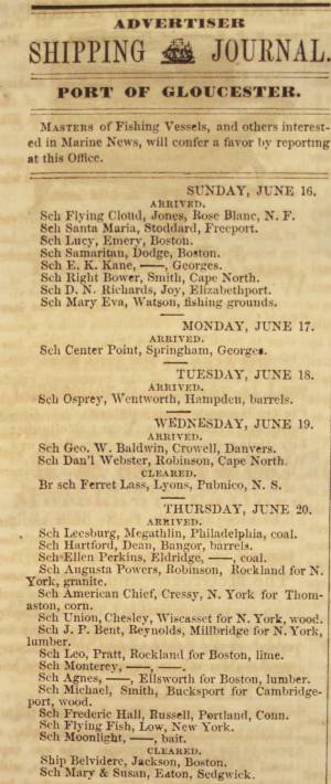
Newsprint
Cape Ann Advertiser
Cape Ann Museum Library & Archive
Notice in the Cape Ann Advertiser announcing arrival of ships into the port of Gloucester, with details of their cargo.
Also filed under: Newspaper / Journal Articles » // Trade Routes and Statistics »
Newspaper
"Lane's studio seldom presents so many attractions to visitors as at the present time. With unwonted rapidity his easel has turned off pictures in answer to the numerous orders which have poured in from all quarters."
Also filed under: Chronology » // Newspaper / Journal Articles » // Studio Descriptions »
Electrotype impression
Collection of Erik Ronnberg
Also filed under: Gloucester Harbor, Inner / Harbor Cove » // Maps »

c.1870 Stereograph card Procter Brothers, Publisher Cape Ann Museum Library & Archive
Also filed under: Historic Photographs » // Stage Rocks / Stage Fort / Stage Head »

Pencil and ink on paper
15 x 22 1/8 in.
Cape Ann Museum, Gloucester, Mass., Gift of Mr. Donald K. Usher, in memory of Mrs. Margaret Campbell Usher, 1984 (2401.19)
Also filed under: Beacons / Monuments / Spindles » // Mackerel Fishing »

Watercolor on paper
8 3/4 x 19 3/4 in.
Cape Ann Museum, Gloucester, Mass., Gift of Rev. and Mrs. A. A. Madsen, 1950
Accession # 1468
Fishing schooners in Gloucester's outer harbor, probably riding out bad weather.
Also filed under: Elwell, D. Jerome » // Schooner (Fishing) »
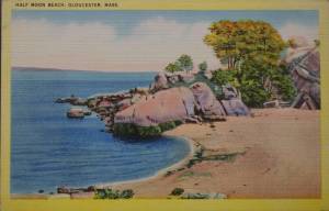
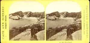
Half Moon Beach is a small crescent of sand, nestled into Stage Fort Park, between Stage Point (where the remains of a Revolutionary War earthworks fort still stands) and a large ledge outcropping that on the far side houses the tablet commemorating the original 1623 settlement of the area by the Dorchester Company. At the time Lane painted his views of the Harbor in which one can see this beach, the entire little peninsula, once known as Fisherman's Field, was probably owned by the B. K. Hough family. The area, including this beach, is now public. From the beach, one can see much of the Outer Harbor, Pavilion Beach, and Ten Pound Island.
– Sarah Dunlap (June, 2015)
c.1870 Stereograph card Cape Ann Museum Library & Archive
Also filed under: Historic Photographs » // Stage Rocks / Stage Fort / Stage Head » // Western Shore »
c.1870 Stereograph card Cape Ann Museum Library & Archive
Also filed under: Historic Photographs »
Newspaper
"Mr. Lane has just completed a third picture of the Western Shore of Gloucester Harbor, including the distance from 'Norman's Woe Rock' to 'Half Moon Beach.' It was painted for Mr. William E. Coffin of Boston, and will be on exhibition at the artist's rooms for only a few days; we advise all our readers who admire works of art, and would see one of the best pictures Mr. Lane has ever executed..."
"...solitary pine, so many years a familiar object and landmark to the fisherman."
c.1870 Stereograph card Cape Ann Museum Library & Archive
Also filed under: Gloucester – City Views » // Historic Photographs » // Stage Rocks / Stage Fort / Stage Head » // Steepbank »
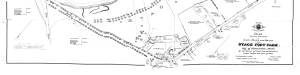
29 x 25 in.
Cape Ann Museum Library & Archive (#089)
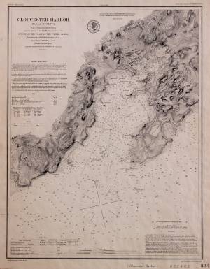
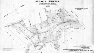
Ernest Bowditch was a landscape gardener. This map shows some of the various names of landmarks around Stage Rocks.
Also filed under: Field Beach / Crescent (or Cressy's) Beach / Long Beach » // Maps » // Stage Rocks / Stage Fort / Stage Head »
Although the exact location and information about the "Lone Pine" or "Old Pine Tree" is unknown, it was a well-recognized landmark in Lane's day. It was situated on the very tip of Dolliver's Neck, and as a result of its height and location near the shoreline, was seen easily from many points, especially across the water. The tree is clearly visible in Dolliver's Neck and the Western Shore from Field Beach, 1857 (inv. 3).
Newsprint
From bound volume owned by publisher Francis Procter
Collection of Fred and Stephanie Buck
"We visited the studio of Mr. Fitz H. Lane a few days since, and were much pleased in examining some fine paintings from the pencil of this talented artist. Among the collection was a view of Long Beach, in this town, with which we were particularly interested.
The scene is taken immediately after a storm. The waves with their snowy crests are rolling in upon the beach, breaking against the sides of a vessel which has been driven ashore. In the background is seen the residence of Mr. Fessenden, and the surrounding scenery; on the right are visible the high headlands near the residence of Mr. Geo. Hovey, while stretching far away in the distance may be seen Fresh Water Cove, Dolliver's Neck, and the Old Pine Tree, the whole forming a beautiful picture and true to Nature.
Several other paintings were in process of completion, one a beautiful sunset scene, which was really beautiful to gaze upon; also a view of a gale at sea, with a gallant ship plunging madly through the waves, forming a striking contrast to the mild placid scene of the picture at its side.
Mr. Lane's paintings are true to nature, and in viewing them one can but admire the skill and genius of this talented artist, We advise all lovers of the art, who wish to spend an hour pleasantly, to visit the studio of Mr. Lane on Locust St. We can assure them that they will come away highly gratified, and have an earnest desire to call again." (1)
(1) See p. 2, column 3, Courtesy of the American Antiquarian Society
Also filed under: Chronology » // Dolliver's Neck » // Fessenden, C. B. » // Fresh Water Cove » // Newspaper / Journal Articles » // Steepbank » // Studio Descriptions »
Newspaper
"Mr. Lane has just completed a third picture of the Western Shore of Gloucester Harbor, including the distance from 'Norman's Woe Rock' to 'Half Moon Beach.' It was painted for Mr. William E. Coffin of Boston, and will be on exhibition at the artist's rooms for only a few days; we advise all our readers who admire works of art, and would see one of the best pictures Mr. Lane has ever executed..."
"...solitary pine, so many years a familiar object and landmark to the fisherman."
c.1860 Stereograph card Cape Ann Museum Library & Archive
Taken from Steepbank, on the western side of Gloucester Harbor, and showing a small boat at anchor in the cove, then the Neck, and the sea beyond.
Also filed under: Dolliver's Neck » // Fresh Water Cove » // Historic Photographs » // Steepbank »
Letter
Cape Ann Museum Library & Archive, Gloucester, Mass.
". . . will fully appreciate all that I have done in my garden, in ornamenting it, with flowers and plants, Rustic Arbours and Statues, and I only wish that you could be here to witness and enjoy his [Dr. J. L. Stevens] expressions of delight and interest, when a new flower attracts his attention, or some beauty of arrangement meets his eye. Samuel [B. Stevens of Castine] he tells me came up with the expectation of going on a voyage to Australia, but when he arrived in Boston he found the vessel with her compliment of men, and it is very uncertain if he goes in her. Your Mother and all at home are well. I yesterday made a sketch of Stage Fort and the surrounding scenery, from the water. Piper has given me an order for a picture from this point of view, to be treated as a sunset. I shall try to make something out of it, but it will require some management, as there is no foreground but water and vessels. One o’clock, it is very hot, the glass indicates 84° in my room, with the windows all open and a light breeze from the east, this is the warmest day . . .
. . . than devoting it to you. Since writing you last I have painted but one picture worth talking about and that one I intend for you if you should be pleased with it. It is a View of the beach between Stage Fort and Steep bank including Hovey’s Hill and residence, Fresh water cove and the point of land with the lone pine tree. Fessenden’s house, likewise comes into the picture. The effect is a mid day light with a cloudy sky, a patch of sunlight is thrown across the beach and the breaking waves, an old vessel lies stranded on the beach with two or three figures, there are a few vessels in the distance and the Field rocks likewise show at the left of the picture. I think you will be pleased with this picture, for it is a very picturesque scene especially the beach, as there are many rocks which come in to destroy the monotony of a plain sand beach, and I have so arranged the light and shade that the effect I think is very good indeed, however you will be better able to judge of that when you see it, the size is 20 x 33. . ."
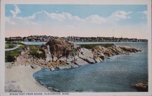
The Stage, as it was known in Lane’s time, now Stage Fort Park, rises from the western shore of the Outer Harbor, just south and west of the Cut and the Blynman Bridge as you leave Gloucester. This was the first settlement of the Massachusetts Bay Colony in 1623 where fourteen men of the Dorchester Company landed and tried in vain to settle and survive through a combination of fishing and farming. They were successful at neither, and in 1626 they moved on and founded Salem.
During the Revolution the Gloucester patriots built a fort on the north side of Half Moon Beach to defend against British invaders which was never needed. The fort was restored for the War of 1812 and again for the Civil War, but again saw no action.
During Lane’s lifetime this area was the Hough farm. Townspeople were generally given free run of the place for strolling and picnics overlooking the harbor. The enormous rounded boulders and ledge outcroppings rose dramatically from the fields above the harbor without the tree cover that partially obscures them today.
Lane did numerous paintings of this area, including many views looking westward from the vantage point onboard a boat in the harbor. In Stage Rocks and the Western Shore of Gloucester Outer Harbor, 1857 (inv. 8) the Stage Rocks frame the west side of Gloucester Harbor and provided a peaceful and bucolic counterpoint to the intense activity of the city waterfront only a mile away across the harbor. Lane also painted the Stage Rocks from the beach just to the north near the Cut and Field Beach, which is on the southern side of the Stage Rocks facing out the harbor entrance to the sea.
Commonwealth of Massachusetts: Southern Essex District Registry of Deeds
1543 plan 0141_0002
The third of the three plans has the references on it. "Plan showing the taking of land, flats and beach for Stage Fort Park…1898..."
Includes a reference to the home of Mary Turnbull which is Steepbank.
Also filed under: Maps » // Steepbank »
c.1870 Stereograph card Cape Ann Museum Library & Archive
Also filed under: Gloucester – City Views » // Half Moon Beach » // Historic Photographs » // Steepbank »
44 x 34 in.
Henry Francis Walling, Map of the Towns of Gloucester and Rockport, Essex Co. Massachusetts. Philadelphia, A. Kollner, 1851
Cape Ann Museum Library & Archive
"Map of the Towns of Gloucester and Rockport, Massachusetts. H.F. Walling, Civil Engineer. John Hanson, Publisher. 1851. Population of Gloucester in 1850: 7,805. Population of Rockport in 1850: 3,213."
Also filed under: Annisquam River » // Brookbank » // Dolliver's Neck » // Fresh Water Cove » // Gloucester Harbor, Outer » // Maps » // Norman's Woe » // Steepbank » // West Gloucester – Little River » // Western Shore »
c.1870 Stereograph card Cape Ann Museum Library & Archive
Also filed under: Half Moon Beach » // Historic Photographs » // Western Shore »
c.1870 Stereograph card Cape Ann Museum Library & Archive
Also filed under: Gloucester – City Views » // Historic Photographs »
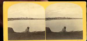
c.1890 Stereograph card Cape Ann Museum Library & Archive
"In the foreground is a clear sheet of water which washes upon the beach beyond. The Pavilion is quite prominent, while upon the rising background can be seen the steeples of the several churchs, the tower of the first Town House, and the Collins School House."
Also filed under: Gloucester – City Views » // Historic Photographs » // Pavilion Hotel »
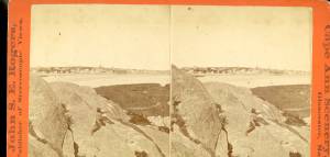
Cape Ann Museum Library & Archive
Stage Fort from Hough's Farm, showing a panorama of the harbor from Pavilion Beach to Fort Point and Rocky Neck.
Also filed under: Field Beach / Crescent (or Cressy's) Beach / Long Beach »
c.1870 Stereograph card Procter Brothers, Publisher Cape Ann Museum Library & Archive
Also filed under: Gloucester Harbor, Outer » // Historic Photographs »
Commonwealth of Massachusetts. Southern Essex District Registry of Deeds. 1543 plan 0141_0003
salemdeeds.com
The third of the three plans has the references on it “Plan showing the taking of land, flats and beach for Stage Fort Park…1898…"
Includes a reference to the home of “Mary Turnbull” which is Steepbank.
Also filed under: Maps »
Commonwealth of Massachusetts: Southern Essex District Registry of Deeds
1543 plan 0141_0001
The third of the three plans has the references on it “Plan showing the taking of land, flats and beach for Stage Fort Park…1898…”
Includes a reference to the home of Mary Turnbull which is Steepbank.
Also filed under: Field Beach / Crescent (or Cressy's) Beach / Long Beach » // Maps » // Steepbank »
Colored lithograph
Cape Ann Museum Library and Archive
Also filed under: Western Shore »
29 x 25 in.
Cape Ann Museum Library & Archive (#089)
Ernest Bowditch was a landscape gardener. This map shows some of the various names of landmarks around Stage Rocks.
Also filed under: Field Beach / Crescent (or Cressy's) Beach / Long Beach » // Half Moon Beach » // Maps »
Nathaniel Babson was a Gloucester merchant and a town selectman from 1847 to 1850, and again in 1860. He was a strong supporter of abolition and brought speakers into town to lecture on the subject. He was part owner of two schooners, the "Dianna" in 1855 and the "Flying Cloud" from 1855 to 1859.
According to notes on his drawings, Lane made a painting for Nathaniel Babson of Stage Rocks, and three paintings for his two daughters of their family home.
Nathaniel Babson (1810–63) married Emmeline Davis Rogers (1816–44) on January 16, 1838. He was the son of Capt. Nathaniel Babson and Eliza Gorham Low and a cousin of Edward and John James Babson, his father and their father being brothers. Emmeline was the daughter of Shubael Gorham Rogers and Mary (Davis) Rogers. They had three children: Emmeline Rogers (1839–1903) who married William Hovey Friend; Maria Rogers (1840–1913), who did not marry, and an unnamed daughter who died in the year of her birth, 1844. In the 1860 census, after his wife’s death, Nathaniel Babson was described as a [house] painter and their daughter Emmeline as a dressmaker.
Shortly before his death, ownership of Nathaniel Babson's home went to Maria and Emma's uncle, Gustavus Babson (1820-1897)
.
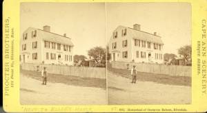
Stereograph card Cape Ann Museum Library & Archive
Stereo view of the house owned by Nathaniel Babson (Emma and Maria). The house was sold to Gustavus shortly before Nathaniel's death.
Also filed under: Babson House » // Historic Photographs »
Captain Harvey Coffin Mackay (1787–1869) and Sally (Sarah) Somes were married in 1816 and built their home at 19 Pleasant Street in 1842. Notably, Mackay was the captain of the packet ship "Boston." For several years before he built his house on Duncan's Point, Lane rented a house on their property (on Elm Street) as his studio and as a home for himself, his mother, and the Winter family.
According to the inscription on Somes Sound, Looking Southerly, 1850 (inv. 178) "Lane made this sketch sitting in the stern of the boat General Gates as we slowly sailed up the sound at Mt. Desert on a lovely afternoon of our first excursion there. He painted a small picture from this his first sketch of that evening. It was sold by Balch to Mrs. Josiah Quincy, Jr. and to Mackay." (1)
(1) Sarah Dunlap and Stephanie Buck, Fitz Henry Lane: Family and Friends (Gloucester, MA: Church & Mason Publishing; in association with the Cape Ann Historical Museum, 2007).

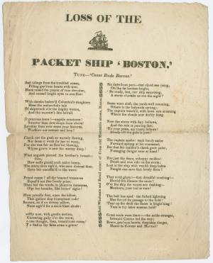
Harris Broadside Collection
Link to broadside in Brown online collection.
Also filed under: "Boston" (Packet Ship) » // Coffin, William E. »
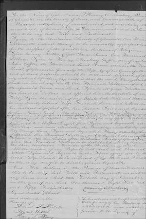
Essex County, MA: Probate File Papers, 1638-1881 (Probate #46669)
For Essex County records online.
". . . and to Mr. Epes Sargent Junr. all my Paintings and more especially the paintings executed by Mr. Fitz Henry Lane."
Marks: Inscribed upper left (in red ink): 77 [numbering system used by curator A. M. Brooks upon Samuel H. Mansfield's donation of the drawings to the Cape Ann Museum]