An online project under the direction of the CAPE ANN MUSEUM
Catalogue Entry
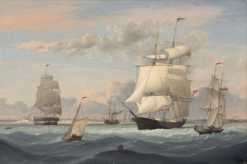
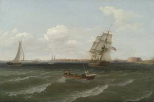
A stiff breeze and a choppy Hudson River help set this lively scene off Manhattan’s West Side. The sloop in the left foreground, with her jib and mainsail reefed, has all the wind she can handle, while the square-riggers around her—a packet ship (left), a clipper ship (center), and a brig (right) are starting to take in sail. The oarsmen in the boat at far left cannot be enjoying their situation while rowing in that rough sea.
A large side-wheel steamer under way in the left background seems unaffected by the wind and waves. A vessel this size was typical for the coastal passenger service between New York and Boston, with stops at larger ports in Rhode Island, the Connecticut coast, and Long Island. Even larger steamers were to be built for that route and the New York-to-Albany service.
The black side-wheel steamer at center was intended for long coastal routes and transoceanic service. Sails were a necessity to steady the vessel’s motion in heavy seas and to keep her moving in the event of an engine problem.
In the distance, between the clipper and the brig, a smaller version of the coastal steamer is barely visible. These vessels were kept busy transporting commuters to Manhattan from Long Island Sound, Brooklyn, and New Jersey, as they were to do for over a century—and in some cases to this day.
– Erik Ronnberg
- Subject Types
: - Vessel Types
: - Other Locales
: - Activities of People
: - Rowing »
- Objects
: - Building Types
:
Historical Materials
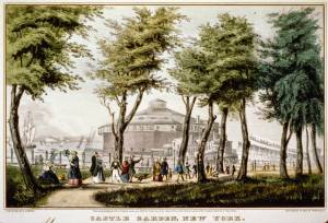
Castle Garden is a circular sandstone fort on an artificial island in Battery Park, on the south end of Manhattan. It was built in 1811 as a military fort during the tensions leading up to the War of 1812. First called Southwest Battery it was renamed Castle Clinton in 1817. In 1821 the United States Army stopped using the fort and it was leased to New York City as a venue for popular entertainment and opened as Castle Garden in 1824. Eventually it was roofed over and served as a beer garden, theater, and exhibition hall. On August 1, 1855, Castle Clinton became the Emigrant Landing Depot, functioning as an immigrant processing facility until 1890 when it was replaced by Ellis Island.
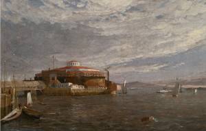
Oil on canvas
10 1/2 x 16 3/8 in.
Inscribed to Jenny Lind
New-York Historical Society, Purchase, Thomas Jefferson Bryan Fund (1977.76)
Also filed under: New York Harbor »
Hand-colored lithograph
Printed by N. Currier, New York
Library of Congress Catalog Number 90714333
Also filed under: Currier (& Ives) – New York »
Color lithograph
Published by N. Currier, New York
LoC Catalog Number 90715981
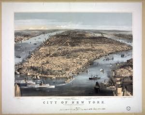
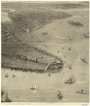
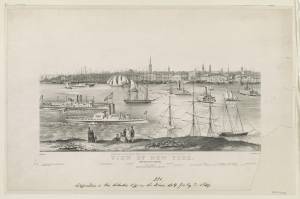
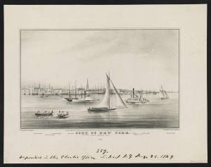
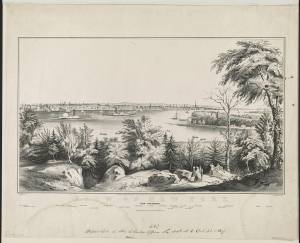
Bird's-eye view of New York City with Battery Park in the foreground and Brooklyn Heights in the lower right corner.
Also filed under: New York Harbor »
Hand-colored lithograph
35 x 25 cm. on sheet 48 x 30 cm.
Published by Magnus & Co.
New York Public Library
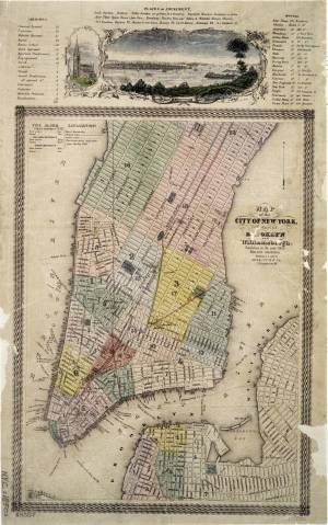
Covers Manhattan up to 34th Street on the west side and 51st Street on the east side. Includes views of New York City and Harbor, and Trinity Church above the upper neat line. Also includes list of churches, hotels, and places of amusement.
Also filed under: Maps » // New York Harbor »
New York City's large population and busy harbor meant that in the mid-nineteenth century it served as the largest domestic market for American products as well as the supplier for most of the export goods for the United States. In 1850 its population was larger than that of Philadelphia and nearly five times as large as that of Boston. (1)
The large broad harbor of New York, easily accessible from the Atlantic, encouraged foreign trade. But it also provided access to western New England and upstate New York via the Hudson River and southern New England via Long Island Sound. Between 1841-1850 New York handled an average of 60% of the U.S. imports and 30.5% of exports. (2) Piers, wharves, and docks ringed the south end of Manhattan: in 1850 over 60 on the East River served the foreign trade, while the 50 or more on the Hudson were filled with steamships and river boats to go up the river. (3) New York kept its position as the largest American seaport through its role as a market, a financial center, and its important position in the trade routes, but another advantage was its low wharfage rates. Although the wharves were notorious for their poor condition, in 1852 the cost to unload 1700 bales of cotton over two days in Boston or Baltimore was $68 while at a Hudson River pier it cost a mere $4.88. (4)
References:
See also: Robert Albion, The Rise of New York Port [1850-1871], David & Charles, 1971.
(1) Edward Spann, The New Metropolis: New York City 1840-1857, Columbia University Press, 1981, p.430.
(2) Spann p.436.
(3) Edwin G. Burrows and Mike Wallace, Gotham: A History of New York City to 1898, Oxford University Press, 1999, p.652.
(4) Burrows & Wallace, p.654
Color lithograph
Published by N. Currier, New York
LoC Catalog Number 90715981
Bird's-eye view of New York City with Battery Park in the foreground and Brooklyn Heights in the lower right corner.
Also filed under: Castle Garden »
Photograph
Johnson, H. and Lightfoot, F.S.: Maritime New York in Nineteenth-Century Photographs, Dover Publications, Inc., New York
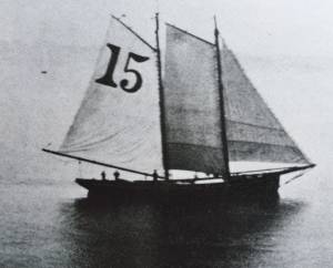
The New York pilot boats would sail out to meet large incoming ships, flying the blue and white flag. The pilot would board the large ship and guide her into harbor. On outgoing trips the pilot boat would pick up the pilot after the ship in his charge had cleared the harbor.
Also filed under: Schooner (Pilot) »
15 1/2 x 13 1/2 in
New York Public Library
Barcode number 33333159142682
Also filed under: Tow Boat / Tug Boat »
Photograph
Johnson, H. and Lightfoot, F.S.: Maritime New York in Nineteenth-Century Photographs, Dover Publications, Inc., New York
Also filed under: Packet Shipping »
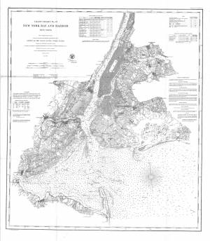
Survey of the Coast of the United States, New York Harbors, Washington, D.C.
Collection of Erik Ronnberg.
Also filed under: Maps »
Lithograph
Published by N. Currier, New York
Library of Congress Catalog Number 2002698126
Also filed under: Currier (& Ives) – New York »
Newspaper
Gloucester Telegraph, p. 2, col. 1
American Antiquarian Society
"F.H. Lane, Esq., with characteristic generosity has loaned some of his grand paintings to increase the interest of the occasion. A look at the Stiff Breeze in New York Harbor, one of the finest of his fine productions, and enough in itself to secure him enduring fame, is worth many times over the price of the admittance fee. A sailor could scarecely gaze upon the brig going in stays, without every moment expecting to hear the command given to 'let go and haul.'"
Also filed under: Gloucester Community / Participation / Other projects » // Newspaper / Journal Articles »
Telegraph and News
p. 2 column 2
"Fine Picture– Mr. F. H. Lane has placed in the Marine Insurance Office a very handsome picture of New York Harbor, which he has just completed. All sorts of vessels are represented in the foreground, with every particular rope in its proper place while in the background is the city with its forests of masts around the wharves it is truly a fine specimen of his artistic skill."
Also filed under: Gloucester, Mass. – Marine Insurance Company » // Newspaper / Journal Articles »
Oil on canvas
10 1/2 x 16 3/8 in.
Inscribed to Jenny Lind
New-York Historical Society, Purchase, Thomas Jefferson Bryan Fund (1977.76)
Also filed under: Castle Garden »
Lithograph
Published by N. Currier, New York
Also filed under: Currier (& Ives) – New York » // Tow Boat / Tug Boat » // Trinity Church »
Hand-colored lithograph
35 x 25 cm. on sheet 48 x 30 cm.
Published by Magnus & Co.
New York Public Library
Covers Manhattan up to 34th Street on the west side and 51st Street on the east side. Includes views of New York City and Harbor, and Trinity Church above the upper neat line. Also includes list of churches, hotels, and places of amusement.
Also filed under: Castle Garden » // Maps »
Oil on canvas
36 x 60 1/4 in.
Museum of Fine Arts, Boston, Gift of Maxim Karolik for the M. and M. Karolik Collection of American Paintings, 1815–65 (48.446)
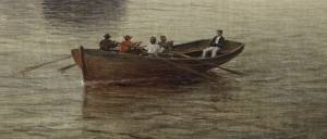
Detail of Whitehall boat.
Also filed under: Whitehall Boat »
Lithograph
Published by N. Currier, New York
Library of Congress Catalog Number 2002698127
Also filed under: Currier (& Ives) – New York »
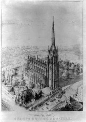
New York's Trinity Church, an Episcopal church located on Broadway at the head of Wall Street, is a visible landmark on the city's skyline. After two others on the site, the grand new one was designed by Richard Upjohn and begun in 1839 and completed in 1846. Its 281-foot Neo-Gothic spire and gilded cross was the highest point in New York for most of the nineteenth century.
Lithograph
Published by N. Currier, New York
Also filed under: Currier (& Ives) – New York » // New York Harbor » // Tow Boat / Tug Boat »
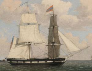
In general, brigs were small to medium size merchant vessels, generally ranging between 80 and 120 feet in hull length. Their hull forms ranged from sharp-ended (for greater speed; see Brig "Antelope" in Boston Harbor, 1863 (inv. 43)) to “kettle-bottom” (a contemporary term for full-ended with wide hull bottom for maximum cargo capacity; see Ships in Ice off Ten Pound Island, Gloucester, 1850s (inv. 44) and Boston Harbor, c.1850 (inv. 48)). The former were widely used in the packet trade (coastwise or transoceanic); the latter were bulk-carriers designed for long passages on regular routes. (1) This rig was favored by Gloucester merchants in the Surinam Trade, which led to vessels so-rigged being referred to by recent historians as Surinam brigs (see Brig "Cadet" in Gloucester Harbor, late 1840s (inv. 13) and Gloucester Harbor at Dusk, c.1852 (inv. 563)). (2)
Brigs are two-masted square-rigged vessels which fall into three categories:
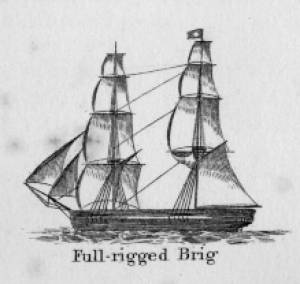
Full-rigged brigs—simply called brigs—were fully square-rigged on both masts. A sub-type—called a snow—had a trysail mast on the aft side of the lower main mast, on which the spanker, with its gaff and boom, was set. (3)
Brigantines were square-rigged on the fore mast, but set only square topsails on the main mast. This type was rarely seen in America in Lane’s time, but was still used for some naval vessels and European merchant vessels. The term is commonly misapplied to hermaphrodite brigs. (4)
Hermaphrodite brigs—more commonly called half-brigs by American seamen and merchants—were square-rigged only on the fore mast, the main mast being rigged with a spanker and a gaff-topsail. Staysails were often set between the fore and main masts, there being no gaff-rigged sail on the fore mast.
– Erik Ronnberg
References:
1. Howard I. Chapelle, The National Watercraft Collection (Washington, DC: Smithsonian Institution, 1960), 64–68.
2. Alfred Mansfield Brooks, Gloucester Recollected: A Familiar History (Gloucester, MA: Peter Smith, 1974), 62–74. A candid and witty view of Gloucester’s Surinam Trade, which employed brigs and barks.
3. R[ichard] H[enry] Dana, Jr., The Seaman's Friend (Boston: Thomas Groom & Co., 1841. 13th ed., 1873), 100 and Plate 4 and captions; and M.H. Parry, et al., Aak to Zumbra: A Dictionary of the World's Watercraft (Newport News, VA: The Mariners’ Museum, 2000), 95.
4. Parry, 95, see Definition 1.
Oil on canvas
17 1/4 x 25 3/4 in.
Cape Ann Museum, Gloucester, Mass., Gift of Isabel Babson Lane, 1946 (1147.a)
Photo: Cape Ann Museum
Detail of brig "Cadet."
Also filed under: "Cadet" (Brig) »
Painting on board
72 x 48 in.
Collection of Erik Ronnberg
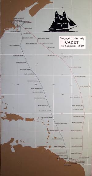
Chart showing the voyage of the brig Cadet to Surinam and return, March 10–June 11, 1840.
Also filed under: "Cadet" (Brig) » // Surinam Trade »

The ensign of the United States refers to the flag of the United States when used as a maritime flag to indentify nationality. As required on entering port, a vessel would fly her own ensign at the stern, but a conventional token of respect to the host country would be to fly the flag of the host country (the United States in Boston Harbor, for example) at the foremast. See The "Britannia" Entering Boston Harbor, 1848 (inv. 49) for an example of a ship doing this. The American ensign often had the stars in the canton arranged in a circle with one large star in the center; an alternative on merchant ensigns was star-shaped constellation. In times of distress a ship would fly the ensign upside down, as can be seen in Wreck of the Roma, 1846 (inv. 250).
The use of flags on vessels is different from the use of flags on land. The importance and history of the flagpole in Fresh Water Cove in Gloucester is still being studied.
The modern meaning of the flag was forged in December 1860, when Major Robert Anderson moved the U.S. garrison from Fort Moultrie to Fort Sumter in Charleston Harbor. Adam Goodheart argues this was the opening move of the American Civil War, and the flag was used throughout northern states to symbolize American nationalism and rejection of secessionism.
Before that day, the flag had served mostly as a military ensign or a convenient marking of American territory, flown from forts, embassies, and ships, and displayed on special occasions like American Independence day. But in the weeks after Major Anderson's surprising stand, it became something different. Suddenly the Stars and Stripes flew—as it does today, and especially as it did after the September 11 attacks in 2001—from houses, from storefronts, from churches; above the village greens and college quads. For the first time American flags were mass-produced rather than individually stitched and even so, manufacturers could not keep up with demand. As the long winter of 1861 turned into spring, that old flag meant something new. The abstraction of the Union cause was transfigured into a physical thing: strips of cloth that millions of people would fight for, and many thousands die for.
– Adam Goodheart, Prologue of 1861: The Civil War Awakening (2011).
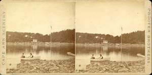
1860s Stereograph card Cape Ann Museum Library & Archive
A view of a Cove on the western side of Gloucester Harbor, with the landing at Brookbank. Houses are seen in the woods back. A boat with two men is in the foreground.
Also filed under: Brookbank » // Fresh Water Cove » // Historic Photographs »
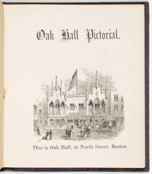
Courtesy American Antiquarian Society, Worcester, Mass. (CL.F9116.011.1854 CL.F9116.011.1854)
Also filed under: Oak Hall »
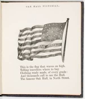
Courtesy American Antiquarian Society, Worcester, Mass. (CL.F9116.011.1854)
Also filed under: Oak Hall »
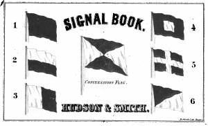
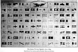
The use of signal flags, for ship-to-ship communication, generally preceded land-based chains of maritime semaphore stations, the latter using flags or rotating arms, until the advent of the electric or magnetic telegraph.
Until the end of the Napoleonic wars, merchant ships generally sailed in convoy as ordered by the escorting warship(s) using a few simple flags. Peace brought independent voyaging, the end of the convoy system, and the realization by various authorities that merchant vessels now needed their own separate means of signaling to each other. This resulted in a handful of rival codes, each with its individual flags and syntax. In general, they each had a section enabling ship identification and also a "vocabulary" section for transmitting selected messages. It was not until 1857 that a common Commercial Code became available for international use, only gradually replacing the earlier ones. All existed side by side for a decade or two.
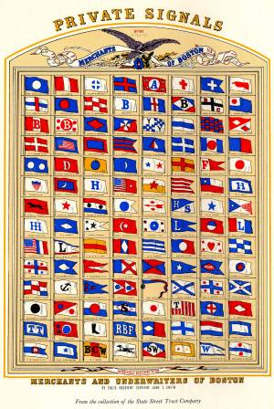
Signal systems for American ships were originally intended to identify a vessel by name and owner; only later were more advanced systems developed to convey messages. Most basic were private signals, or "house flags", each of a different design or pattern, identifying the vessel's owner; identification charts were local and poorly distributed, limiting their usefulness. A secondary signal, a flag or large pennant bearing the vessel's name, was sometimes flown by larger ships, but pictorial records of them are uncommon. These private signal flags usually flew from the foremasthead or main masthead if a three master ship. Pilot boats had their own identifying flags, blue and white as seen in Spitfire Entering Boston Harbor, n.d. (inv. 536). Small vessels, such as schooners, often had a "tell-tale" pennant, an often-unmarked and often red flag, that was used to determine wind direction.
A numerical code flag system, identifying vessels by the code numbers, was introduced by Captain Frederick Marryat R.N. in 1817 for English vessels. American vessels soon adopted this system. Elford's "marine telegraphic system" was the first American equivalent to the Marryat code flags, first issued in 1823, and with changes, remaining in use until the late 1850s. Most of the signal flags on vessels depicted by Lane use Elford's; Brig "Antelope" in Boston Harbor, 1863 (inv. 43) is a noteworthy example of his depiction of Marryat's. The Elford's Code was popular in America on account of its simplicity and only required six blue and white flags. Eventually these changed to red and white, although it is unclear exactly when this happened. Instructions and a key ot the Elford's Code's use are included in successive editions of the Boston Harbor Signal Book.
Whereas the other codes employ at least ten flags of diverse shapes and colours, there are only six Elford flags in total, representing the numbers one to six. All are uniformly rectangular and monochrome in colour (either blue and white or red and white—or even black and white as in an early photograph). Selected from these six flags each individual vessel is allotted a combination of four flags to be prominently displayed as a vertical hoist. Reading from above down these convey its "designated number." Armed with this number and the type of vessel (e.g. ship, bark, brig, schooner /or steamer) the subject can be uniquely identified by reference to a copy of the Boston Harbor Signal Book for the appropriate year.
– A. Sam Davidson
As reproduced in Yankee Sailing Ship Cards by Allan Forbes and Ralph M. Eastman (Boston: State Street Trust Company, 1948).
Also filed under: "Eastern Star" (Bark) » // Forbes, Robert Bennet »
Harvard Depository: Widener (NAV 578.57)
For digitized version, click here.
Also filed under: Boston Harbor »
Boston: Eastburn's Press
New York Public Library
Complete book is included in Google Books, click here.
In The American Neptune 3, no. 3 (July 1943): 205–21.
Peabody Essex Museum
Descriptions of Marryat, Elford, Rogers, and commercial code signal systems, and private signals. Includes illustrations of flag systems with color keys.