An online project under the direction of the CAPE ANN MUSEUM
Catalogue Entry
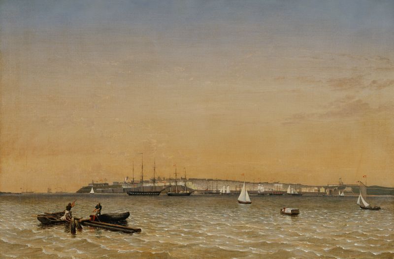
Mid-nineteenth century Porto Rico (as then spelled) was a rich source of sugar and its derivative products for North America and Europe. Cane sugar, molasses, and rum made up the bulk of cargos loaded by American merchant vessels. Those vessels, particularly from New England ports, brought to the island huge quantities of dried codfish for the sugar plantations to feed their slaves. This trade was the foundation of Sidney Mason’s wealth and civic prominence in his native Gloucester and led to his post as American Consul in Puerto Rico from 1829 to 1835. It led as well to marriage and business, and a second home in New York City. (1-3)
In 1850, Lane traveled to New York where he drew and painted views of the harbor and vessel activity, two of which were possibly painted for Mason, who may also have engaged him to paint a view of San Juan at that time. Travel to the West Indies by steamship from New York would have been the most expeditious means to get there, and a stop at Baltimore (either outbound or returning) would have made the voyage all the more productive. The discovery by Melissa Trafton, of a print by Augustus de Vaudricourt with a nearly identical composition, also has introduced the possiblity that Lane did not make the trip, but was copying the lithograph.
Lane’s view of San Juan exhibits his usual deft eye for detail in buildings as well a ships. There are three— possibly more—examples of Bermuda-rigged sloops in this scene—a variant of the sloop rig unseen in New England until the twentieth century. The presence of a French frigate reflects that nation’s interests in the Caribbean—an area of major importance to several European nations. (4)
The foreground may reflect the interests of many nations in Caribbean forest products, but not (in this period) those of Puerto Rico. Long described as two boats salvaging mahogany logs cut from that island’s forests, this activity must be reconsidered. Contemporary reports indicate that there was no logging of mahogany in Puerto Rico for export, though it may have been imported for ornamental trees or as finished furniture. If mahogany was once native to the island, it was either logged out or was to be found in forests inaccessible due to surrounding marshlands and an absence of canals to transport the timber. (5-7)
In any case, the logs depicted are too small for marketable mahogany, the trees most suitable for harvest being 100 feet and more in height and upwards of 40 feet in girth above the roots. More likely, the logs depicted are mast timber—probably pine or spruce from North America—which were part of a ship’s deck load, got loose in a storm, and went adrift. That they are floating so high in the water rules out any of the dense tropical hardwoods used for wharf timbers and other woodwork requiring resistance to rot and wear. (8-9)
– Erik Ronnberg
References:
1. Edmund Flagg, Superintendent, “Report on the Commercial Relations of the United States with all Foreign Nations,” Vol. 1 (Washington, DC: Cornelius Wendell, Printer, 1856), pp. 207–216.
2. “Commerce and Navigation. Report of the Secretary of the Treasury, 1850” (Washington, DC: Gideon and Co., Printers, 1851), pp. 124, 125 (fish), 218, 219 (distilled spirits), 220, 221 (molasses), 226, 227 (sugar).
3. Stephanie Buck, “Mason, Sidney” (2015). See Historical Materials: People.
4. L. R. Hamersly & Co., “A Naval Encyclopaedia” (Philadelphia, 1884. Reprint: Detroit, MI: Gale Research Co., 1971), p. 504, under “‘Mudian.”
5. The salvaging of the “mahogany logs” comes from a file at the Frick Art Reference Library which was cited by John Wilmerding in “Fitz Hugh Lane” (1971). (Reprinted with revised title “Fitz Henry Lane”: Cape Ann Museum, 2005), pp. 42, 43, and note 7.
6. “Commerce and Navigation…1850,” pp. 204, 205 (wood, unmanufactured).
7. Edmund Flagg, Superintendent, “Report of the Commercial Relations of the United States with All Foreign Nations,” Vol. 1 (Washington, DC: Cornelius Wendell, Printer, 1856), pp. 207–209.
8. Herbert I. Edlin, “What Wood is That?” (New York, NY: The Viking Press, Inc., 1969), pp. 129–131 and wood sample No. 22.
9. George N. Lamb, “How to Identify Genuine Mahogany and Avoid Substitutes” (Chicago, IL: The Mahogany Association, Inc., 1940), pp. 2–4, 17.
- Subject Types
: - Vessel Types
: - Other Locales
: - Activities of People
: - Rowing »
- Objects
:
Historical Materials
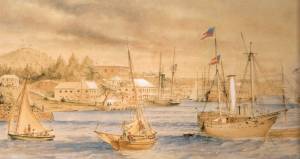
St. George's Historical Society
Detail of painting of St. George's Harbour, Bermuda, during US Civil War, with a Confederate blockade runner anchored in the foreground.
Filed under: Puerto Rico » // Sloop »
A Naval Encyclopaedia:
Dictionary of nautical words and phrases
Special Articles on Naval Art and Science
Philadelphia: L.R. Hamersly & Co.
'Mudian, "Mugian, or Bermudian. A boat special to the Bermuda islands, usually decked, with the exception of a hatch; from 2 to 20 tons burden; it is short, of good beam, and great draft of water abaft, the stem and keel forming a curved line. It carries an immense quantity of ballast. Besides a long main- and short jib-boom, it has a long, taperking, raking mast, stepped just over the forefoot, generally unsupported by shrouds or stays; on it a jib-headed mainsail is hoisted to a height of twice, and sometimes three times, the length of the keel. This sail is triangular, stretched at its foot by a long boom. The only other sail is a small foresail or jib. They claim to be the fastest craft in the world for working to windward in smooth water, it being recorded of one that she made five miles dead to windward in the hour during a race; and though they may be laid over until they fill with water, they will not capsize.
Filed under: Sloop »
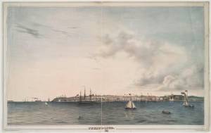
Lithograph, hand-colored
33.7 x 54.3 cm.
New York Public Library, The Miriam and Ira D. Wallach Division of Art, Prints and Photographs: Print Collection
Filed under: De Vaudricourt, Augustus » // Puerto Rico »
Report
Washington: Cornelius Wendell, Printer
Describes trade between the US, Puerto Rico and other West Indian territories, with notes on their histories and descriptions of the countries and their products.
Filed under: Puerto Rico »
St. George's Historical Society
Detail of painting of St. George's Harbour, Bermuda, during US Civil War, with a Confederate blockade runner anchored in the foreground.
Also filed under: Sloop »
Lithograph, hand-colored
33.7 x 54.3 cm.
New York Public Library, The Miriam and Ira D. Wallach Division of Art, Prints and Photographs: Print Collection
Also filed under: De Vaudricourt, Augustus »
Report from the Register of the Treasury of the Commerce and Navigation of the United States for the year ending the 30th June, 1850
Tables showing exports of fish and imports of wood, liquor, sugar, and other commodities to and from all countries of the world, and highlighting trade with the Spanish West Indies.
Report
Washington: Cornelius Wendell, Printer
Describes trade between the US, Puerto Rico and other West Indian territories, with notes on their histories and descriptions of the countries and their products.
Government-owned vessels were mainly concerned with defense of the nation (i.e. the U.S. Navy), the regulation of foreign commerce via enforcement of tariffs and seizure of contraband (i.e. the U.S. Revenue Service), and aids to navigation (i.e. the U.S. Lighthouse Service; coastal life-saving was in the hands of civic organizations).
Naval vessels were classified according to a multitude of duties, which in turn determined hull form and size, propulsion (sail, engine-powered, oars), and numbers and duties of crews.
Revenue service vessels varied from small harbor craft, swift-sailing schooners for coastal and harbor patrols, and large square-rigged (and later engine-powered) ships for off-shore duty. These vessels worked closely with customs houses in seaports with significant foreign commerce.
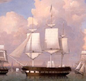
Oil on canvas
15 3/4 x 23 1/4 in.
Hunter Museum of Art, Chattanooga, Tenn., Museum Purchase (1968.4)
Detail of navel vessel.
Also filed under: "Constitution" (U.S. Frigate) »
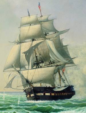
Oil on canvas
28 x 42 in.
National Gallery of Art, Washington, D.C., Corcoran Collection (Gift of Mr. and Mrs. Lansdell K. Christie) (2014.136.82)
Detail of naval vessel.
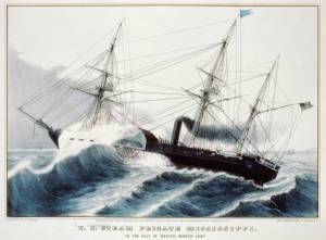
Hand-colored lithograph
Published by N. Currier, New York
Library of Congress catalog number 93514426
Also filed under: Currier (& Ives) – New York »
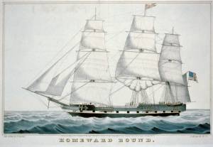
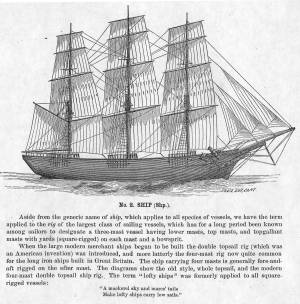
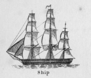
The term "ship," as used by nineteenth-century merchants and seamen, referred to a large three-masted sailing vessel which was square-rigged on all three masts. (1) In that same period, sailing warships of the largest classes were also called ships, or more formally, ships of the line, their size qualifying them to engage the enemy in a line of battle. (2) In the second half of the nineteenth century, as sailing vessels were replaced by engine-powered vessels, the term ship was applied to any large vessel, regardless of propulsion or use. (3)
Ships were often further defined by their specialized uses or modifications, clipper ships and packet ships being the most noted examples. Built for speed, clipper ships were employed in carrying high-value or perishable goods over long distances. (4) Lane painted formal portraits of clipper ships for their owners, as well as generic examples for his port paintings. (5)
Packet ships were designed for carrying capacity which required some sacrifice in speed while still being able to make scheduled passages within a reasonable time frame between regular destinations. In the packet trade with European ports, mail, passengers, and bulk cargos such as cotton, textiles, and farm produce made the eastward passages. Mail, passengers (usually in much larger numbers), and finished wares were the usual cargos for return trips. (6) Lane depicted these vessels in portraits for their owners, and in his port scenes of Boston and New York Harbors.
Ships in specific trades were often identified by their cargos: salt ships which brought salt to Gloucester for curing dried fish; tea clippers in the China Trade; coffee ships in the West Indies and South American trades, and cotton ships bringing cotton to mills in New England or to European ports. Some trades were identified by the special destination of a ship’s regular voyages; hence Gloucester vessels in the trade with Surinam were identified as Surinam ships (or barks, or brigs, depending on their rigs). In Lane’s Gloucester Harbor scenes, there are likely (though not identifiable) examples of Surinam ships, but only the ship "California" in his depiction of the Burnham marine railway in Gloucester (see Three Master on the Gloucester Railways, 1857 (inv. 29)) is so identified. (7)
– Erik Ronnberg
References:
1. R[ichard)] H[enry] Dana, Jr., The Seaman’s Friend, 13th ed. (Boston: Thomas Groom & Co., 1873), p. 121 and Plate IV with captions.
2. A Naval Encyclopaedia (Philadelphia: L. R. Hamersly & Co., 1884), 739, 741.
3. M.H. Parry, et al., Aak to Zumbra: A Dictionary of the World’s Watercraft (Newport News, VA: The Mariners’ Museum, 2000), 536.
4. Howard I. Chapelle, The History of American Sailing Ships (New York: W.W. Norton & Co., 1935), 281–87.
5. Ibid.
6. Howard I. Chapelle, The National Watercraft Collection (Washington, DC: Smithsonian Institution, 1960), 26–30.
7. Alfred Mansfield Brooks, Gloucester Recollected: A Familiar History (Gloucester, MA: Peter Smith, 1974), 67–69.
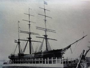
Photograph
From American Clipper Ships 1833–1858, by Octavius T. Howe and Frederick C. Matthews, vol. 1 (Salem, MA: Marine Research Society, 1926).
Photo caption reads: "'Golden State' 1363 tons, built at New York, in 1852. From a photograph showing her in dock at Quebec in 1884."
Also filed under: "Golden State" (Clipper Ship) »
_sm.jpg)

Oil on canvas
24 x 35 in.
Peabody Essex Museum, Salem, Mass.
Walters' painting depicts the "Nonantum" homeward bound for Boston from Liverpool in 1842. The paddle-steamer is one of the four Clyde-built Britannia-class vessels, of which one is visible crossing in the opposite direction.
View related catalogue entries (2) »
Also filed under: Packet Shipping » // Walters, Samuel »

The ensign of the United States refers to the flag of the United States when used as a maritime flag to indentify nationality. As required on entering port, a vessel would fly her own ensign at the stern, but a conventional token of respect to the host country would be to fly the flag of the host country (the United States in Boston Harbor, for example) at the foremast. See The "Britannia" Entering Boston Harbor, 1848 (inv. 49) for an example of a ship doing this. The American ensign often had the stars in the canton arranged in a circle with one large star in the center; an alternative on merchant ensigns was star-shaped constellation. In times of distress a ship would fly the ensign upside down, as can be seen in Wreck of the Roma, 1846 (inv. 250).
The use of flags on vessels is different from the use of flags on land. The importance and history of the flagpole in Fresh Water Cove in Gloucester is still being studied.
The modern meaning of the flag was forged in December 1860, when Major Robert Anderson moved the U.S. garrison from Fort Moultrie to Fort Sumter in Charleston Harbor. Adam Goodheart argues this was the opening move of the American Civil War, and the flag was used throughout northern states to symbolize American nationalism and rejection of secessionism.
Before that day, the flag had served mostly as a military ensign or a convenient marking of American territory, flown from forts, embassies, and ships, and displayed on special occasions like American Independence day. But in the weeks after Major Anderson's surprising stand, it became something different. Suddenly the Stars and Stripes flew—as it does today, and especially as it did after the September 11 attacks in 2001—from houses, from storefronts, from churches; above the village greens and college quads. For the first time American flags were mass-produced rather than individually stitched and even so, manufacturers could not keep up with demand. As the long winter of 1861 turned into spring, that old flag meant something new. The abstraction of the Union cause was transfigured into a physical thing: strips of cloth that millions of people would fight for, and many thousands die for.
– Adam Goodheart, Prologue of 1861: The Civil War Awakening (2011).
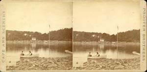
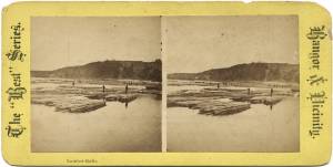
1860s Stereograph card Cape Ann Museum Library & Archive
A view of a Cove on the western side of Gloucester Harbor, with the landing at Brookbank. Houses are seen in the woods back. A boat with two men is in the foreground.
Also filed under: Brookbank » // Fresh Water Cove » // Historic Photographs »
Courtesy American Antiquarian Society, Worcester, Mass. (CL.F9116.011.1854 CL.F9116.011.1854)
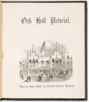
Also filed under: Oak Hall »
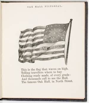
Courtesy American Antiquarian Society, Worcester, Mass. (CL.F9116.011.1854)
Also filed under: Oak Hall »
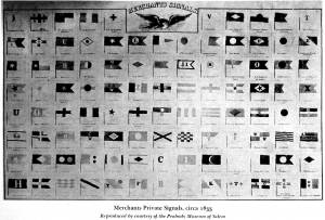
The use of signal flags, for ship-to-ship communication, generally preceded land-based chains of maritime semaphore stations, the latter using flags or rotating arms, until the advent of the electric or magnetic telegraph.
Until the end of the Napoleonic wars, merchant ships generally sailed in convoy as ordered by the escorting warship(s) using a few simple flags. Peace brought independent voyaging, the end of the convoy system, and the realization by various authorities that merchant vessels now needed their own separate means of signaling to each other. This resulted in a handful of rival codes, each with its individual flags and syntax. In general, they each had a section enabling ship identification and also a "vocabulary" section for transmitting selected messages. It was not until 1857 that a common Commercial Code became available for international use, only gradually replacing the earlier ones. All existed side by side for a decade or two.
Signal systems for American ships were originally intended to identify a vessel by name and owner; only later were more advanced systems developed to convey messages. Most basic were private signals, or "house flags", each of a different design or pattern, identifying the vessel's owner; identification charts were local and poorly distributed, limiting their usefulness. A secondary signal, a flag or large pennant bearing the vessel's name, was sometimes flown by larger ships, but pictorial records of them are uncommon. These private signal flags usually flew from the foremasthead or main masthead if a three master ship. Pilot boats had their own identifying flags, blue and white as seen in Spitfire Entering Boston Harbor, n.d. (inv. 536). Small vessels, such as schooners, often had a "tell-tale" pennant, an often-unmarked and often red flag, that was used to determine wind direction.
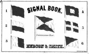
A numerical code flag system, identifying vessels by the code numbers, was introduced by Captain Frederick Marryat R.N. in 1817 for English vessels. American vessels soon adopted this system. Elford's "marine telegraphic system" was the first American equivalent to the Marryat code flags, first issued in 1823, and with changes, remaining in use until the late 1850s. Most of the signal flags on vessels depicted by Lane use Elford's; Brig "Antelope" in Boston Harbor, 1863 (inv. 43) is a noteworthy example of his depiction of Marryat's. The Elford's Code was popular in America on account of its simplicity and only required six blue and white flags. Eventually these changed to red and white, although it is unclear exactly when this happened. Instructions and a key ot the Elford's Code's use are included in successive editions of the Boston Harbor Signal Book.
Whereas the other codes employ at least ten flags of diverse shapes and colours, there are only six Elford flags in total, representing the numbers one to six. All are uniformly rectangular and monochrome in colour (either blue and white or red and white—or even black and white as in an early photograph). Selected from these six flags each individual vessel is allotted a combination of four flags to be prominently displayed as a vertical hoist. Reading from above down these convey its "designated number." Armed with this number and the type of vessel (e.g. ship, bark, brig, schooner /or steamer) the subject can be uniquely identified by reference to a copy of the Boston Harbor Signal Book for the appropriate year.
– A. Sam Davidson
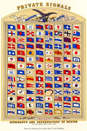
As reproduced in Yankee Sailing Ship Cards by Allan Forbes and Ralph M. Eastman (Boston: State Street Trust Company, 1948).
Also filed under: "Eastern Star" (Bark) » // Forbes, Robert Bennet »
Harvard Depository: Widener (NAV 578.57)
For digitized version, click here.
Also filed under: Boston Harbor »
Boston: Eastburn's Press
New York Public Library
Complete book is included in Google Books, click here.
In The American Neptune 3, no. 3 (July 1943): 205–21.
Peabody Essex Museum
Descriptions of Marryat, Elford, Rogers, and commercial code signal systems, and private signals. Includes illustrations of flag systems with color keys.
The timber trade played an important role in New England’s economy from Colonial days through the mid-19th century, supplying the vast quantities of lumber which a rapidly growing nation demanded. While Cape Ann’s woodlands were depleted early on, timber continued to be harvested from northern New England and the Maritime Provinces right up to the Civil War.
With a deep and safe harbor, Gloucester often served as a layover spot where vessels bound from Maine to Boston, New York or Baltimore and heavily laden with lumber could ride out bad weather. Because of this, Fitz Henry Lane’s paintings of Gloucester Harbor often show a schooner or a brig, loads of lumber clearly visible on their decks, sheltering along the Western Shore.
References:
Honey, Mark E., "King Pine, Queen Spruce, Jack Tar," An Intimate History of Lumbering on the Union River, Volumes 1-5. This source, in its entirety, lays down the foundation of Downeast Maine's unique culture which was built upon pine lumber and timber, the cod fisheries, coasting, shipbuilding, and the interrelationships of family and community.

1852 Photograph
Also filed under: Schooner (Coasting / Lumber / Topsail / Packet / Marsh Hay) »
Advertisement for The Bangor News Company, est. January 31, 1881 Castine Historical Society Collections (2008.02)
Also filed under: Historic Photographs »
"The Maine Register for the Year 1855, embracing State and County Officers, and an abstract of the law and resolves; together with a complete business directory of the state, and a variety of useful information."
Details about Maine's lumber trade in 1855, see pp. 250–52
Also filed under: Castine » // Schooner (Coasting / Lumber / Topsail / Packet / Marsh Hay) »
Sidney Mason (1799–1871) was the second of the four sons of John Mason and Phene Shipley. One of his brothers, Alphonso, was killed in the famous disaster of the burning of the steamship "Lexington." His father was master of the Gloucester workhouse, and a tavern keeper who owned the Puritan House hotel. His father, John Mason, was also the cartographer who drew the 1830/31 map of Gloucester. Lane may have been paid to color this map for sale by W.E.P. Rogers.
At the age of twelve, Sidney went to Boston, where he got a job polishing brasses. Over the course of several years, he rose to the position of clerk. In 1820, he went to the West Indies as supercargo and settled in San Juan, Puerto Rico, where he became a wealthy sugar merchant. From 1829 to 1835, he was also the first United Sates Consul in San Juan and it was there that he met and married his first wife Marequita B. Dorado. They had two children, Catalina Julia and Sidney Alphonso, and returned to live in Gloucester where Marequita died in 1835.
After her death, Sidney installed his children in American schools and embarked on an extensive tour of Europe, only returning on the death of his son in 1841. He took up residence in New York, and two years later he married Catherine Gartz Robb, a schoolmate of his daughter. She outlived him by several decades, retiring to Paris, where she ran a small hotel “frequented by the musical and artistic celebrities of the day.” (1)
His daughter Catalina married Theodorus Bailey Myers. It was their daughter, Cassie Mason Mayers, who married Julian James, and in 1913, gave to the City of Gloucester the “beautiful and interesting painting of Gloucester and its harbor painted some sixty years ago by Mr. Lane." It had previously hung in her grandfather’s New York house. (2)
In 1849, Sidney purchased a lot of land next to Pavilion Beach in Gloucester and, removing the old windmill that stood on it, built the Pavilion Hotel there. By 1850, he also owned the old family hostelry—the Atlantic House hotel (now the Blackburn Tavern) on the corner of Washington and Main Streets.
Sidney Mason owned several Lane paintings, including one of his former San Juan estate that he commissioned Lane to paint c.1850.
– Stephanie Buck (2015)
(1) Cassie Mason (Meyers) James, Biographical Sketches of the Bailey-Myers-Mason Families (Library of Congress, 1908), 48.
(2) Gloucester City Archives: Letters to City Council for July 15, 1913, #230.
Newspaper
Gloucester Telegraph
"The Cape Ann Sanitary Fair: [Held Tues–Fri in the Pavilion Hotel by favor of the owner Sidney Mason of New York] In another part of the Hall hangs a fine picture, the generous gift of our own Artist, Mr. Lane. The Subject is "Coffin's Beach," as seen from the "Loaf." This is the most costly article on sale in the rooms, and is valued at $100. It will be disposed of by tickets of $1 each."
Also filed under: Chronology » // Coffin's Beach » // Gloucester, Mass. – 1863 Sanitary Fair » // Newspaper / Journal Articles »
Newsprint
Gloucester Telegraph
Cape Ann Museum Library & Archive
At a Sanitary Fair held at the Pavilion "obtained through the favor and generosity of the owner, Mr. SIDNEY MASON, of New York, and to whom many thanks are due." "... hangs a fine picture, the generous gift of our own Artist, Mr. Lane. The Subject is "Coffin's Beach," as seen from the "Loaf." This is the most costly article on sale in the rooms, and is valued at $100. It will be disposed of by tickets $1 each."
Two paintings by Lane, Little Good Harbor Beach and View from the Loaf were on sale at the Fair.