An online project under the direction of the CAPE ANN MUSEUM
Catalogue Entry
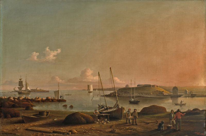
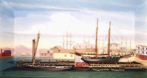
This painting is taken from the 1847 drawing of the view of Fort Point and Ten Pound Island, Lane then painted three versions, likely all in the 1847-48 period. In this View of Gloucester Harbor, 1848, the sun is about to set casting a reddish light across Harbor Cove and Gloucester’s Outer Harbor. A light breeze barely causes ripples on the water while the sails of a lumber brig and a schooner hang slack.
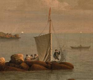
All is serenely quiet on the water and on Fort Point, and the foreground activity has become the center of attention. At left, a small sloop – probably a party boat – is shoving off from the end of Duncan’s Point Rocks, perhaps having picked up another passenger to enjoy an evening sail around the harbor. These were the early days of tourism and vacationing on Cape Ann, and Lane would be depicting more of it in the next decade.
Below, at far left, is a dory used for shore fishing, though what type of fishing is uncertain. The barrel on board could have been used for lobster bait, or the lobsters, reflecting a growing market for the crustaceans. Strewn around the dory are a discarded codfish, a skate, and an old vessel’s rudder. More detritus of this sort would appear in later harbor views.
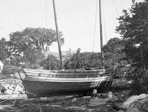
At center in the foreground is a double-ended New England boat with the type’s characteristic rig: two unstayed masts with two gaff-headed sails, and no bowsprit or jib. Her hull is of the more common lapstrake construction, coated with oil and pitch instead of painted. She is decked and probably fitted with a cuddy in the bow to provide shelter for the crew, but has no stove or fireplace. This workboat type had its origin in the colonial shallops, evolving slowly to this design by the late 18th century. Its smooth-planked square-stern form (seen at its mooring in Harbor Cove) was probably an early 19th century offshoot.
Alongside the New England boat, a table has been set up for dressing the catch. The last cod is being gutted, its head having already joined the others in a pile beside the table. Two of the boat’s crew are carrying off dressed cod in a hand barrow to sell to a nearly fish dealer, or to a restaurant catering to summer visitors. Fish caught and prepared like this were intended for the local market and would fetch a higher price than if salted and dried.
Scattered on the ground around the New England boat is an assortment of detritus: two large fronds of kelp, a matted clump of seaweed, some clam shells, and the bottom of a broken earthenware jug. Just beyond is the New England boat’s anchor—one of the earliest depictions of a “fisherman’s anchor” whose wooden stock was wedged in a diamond-shaped eye in the anchor’s shank, just below the hawser ring. Fitting the anchor stock this way made it easy to remove for stowing.
At far right in the harbor is a small double-ended boat being paddled (or poled, the water being so shallow at low tide) by a single occupant. Though it somewhat resembles a Maine peapod, it is too early to have been a variant of that type. It may simply have been a scaled-down version of a New England boat, an anomaly amidst our standard classifications of this period’s workboats.
At far right in the foreground are two men in conversation, the one in brown attire leaning on his clamming fork, a basket of fresh-dug clams and his dog beside him. Is the artist (Lane) posing himself as a clamdigger in his painting? His facial features seem to hint at this possibility though there are no signs of crutches or other evidence of his infirmity. Having just moved back to Gloucester, he would have only begun to find his way back into the social fabric of Cape Ann. Was placing himself in his paintings a way of reasserting his identity as a Gloucester son?
– Erik Ronnberg
- Subject Types
: - Landscape Types
: - Beach »
- Seasons / Weather
: - Sunset »
- Vessel Types
: - Vessel Activites
: - Beached »
- Cape Ann Locales
: - Animals & People
: - Dogs / Cats »
- Women »
- Activities of People
: - Objects
: - Anchor »
- Barrel »
- Cod »
- Wheelbarrow »
- Building Types
:
Historical Materials
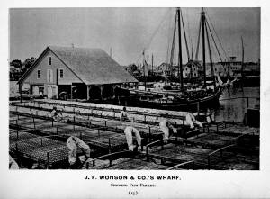
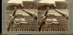
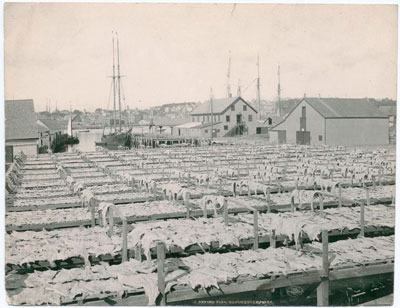
In the days prior mechanical refrigeration, salting and drying were the most common methods of preserving fish. Split cod were spread out on wooden racks, called "fish flakes," to dry. Drying time could take days, depending on weather and temperature. Warm, sunny weather could speed up the drying time, but also "burn" the fish, spoiling its texture and flavor. To prevent this, canvas awnings were stretched over wooden frames built onto the flakes. In wet weather, wooden boxes were placed over the flakes to protect them.
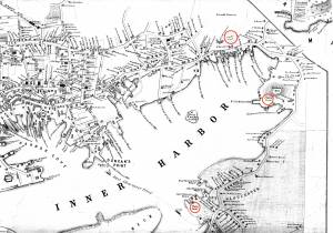
There were several large flake yards in Gloucester in Lane's day. One was situated between Battery Street and the beach, on the long point of land leading to the Fort, and is clearly shown in the 1851 Walling map.
c.1900.
Also filed under: Drying Fish »
Stereograph card Cape Ann Museum Library & Archive
Also filed under: Cod / Cod Fishing » // Drying Fish » // Historic Photographs »

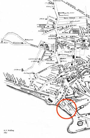
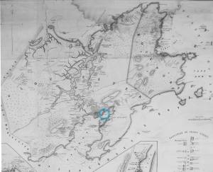
1851 44 x 34 in. Henry Francis Walling, Map of the Towns of Gloucester and Rockport, Essex Co. Massachusetts. Philadelphia, A. Kollner, 1851 Cape Ann Museum Library & Archive
"Map of the Towns of Gloucester and Rockport, Massachusetts. H.F. Walling, Civil Engineer. John Hanson, Printer. 1851. Population of Gloucester in 1850 7,805. Population of Rockport in 1850 3,213."
Also filed under: Baptist Church (Old, First, 1830) (Pleasant Street) » // Burnham Brothers Marine Railway » // Duncan's Point » // Five Pound Island » // Gloucester Harbor, Inner / Harbor Cove » // Harbor Methodist Church (Prospect Street) » // Low (Frederick G.) wharves » // Pavilion Hotel » // Procter Brothers » // Ropewalk » // Vincent's Cove » // Western Shore »

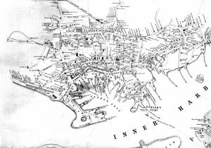
1834–35 24 x 38 in. Gloucester City Archives
"Drawn on a scale of one hundred feet to an inch. By John Mason 1834–45 from Actual Survey showing every Lott and building then standing on them giving the actual size of the buildings and width of the streets from the Canal to the head of the Harbour & part of Eastern point as farr as Smith's Cove and the Shore of the same with all the wharfs then in use. Gloucester Harbor 1834–35."
This map is especially helpful in showing the wharves of the inner harbor at the foot of Washington Street.

24 x 38 in.
Gloucester City Archives
"Drawn on a scale of one hundred feet to an inch. By John Mason 1834–45 from Actual Survey showing every Lott and building then standing on them giving the actual size of the buildings and width of the streets from the Canal to the head of the Harbour & part of Eastern point as farr as Smith's Cove and the Shore of the same with all the wharfs then in use. Gloucester Harbor 1834–35."
This map is especially useful in showing the Fort.
Also filed under: Fort (The) and Fort Point » // Maps » // Mason, John » // Pavilion (Publick) Beach » // Town / Public Landings »
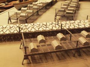
Wood drying racks, metal split salt fish. Scale: ½" = 1' (1:24)
Original diorama components made, 1892; replacements made 1993.
Cape Ann Museum, from Gloucester Chamber of Commerce, 1925 (2014.071)
Fish flakes are wood drying racks for salt codfish, and have been used for this purpose in America since colonial times.
Also filed under: Drying Fish »
44 x 34 in.
John Hanson, Publisher
Cape Ann Museum Library & Archive
"Map of the Towns of Gloucester and Rockport, Massachusetts. H.F. Walling, Civil Engineer. John Hanson, Publisher. 1851. Population of Gloucester in 1850 7,805. Population of Rockport in 1850 3,213."
Also filed under: Maps »
In 1849, Lane bought a small lot of land on top of a hill that jutted into Gloucester Inner Harbor. The name Duncan's Point refers alternatively to the entire hill, or only to the rocks that form a point beneath the current Coast Guard Station. The hilltop was vacant when Lane bought the property. He designed and built a gabled stone house on the hill, the northwest room of which was his studio. He lived there with his sister Sarah and her husband, Ignatius Winter, until he died in 1865, having bequeathed the house to his friend, Joseph L. Stevens, Jr. (1)
Reference:
1. Sarah Dunlop and Stephanie Buck, Fitz Henry Lane: Family and Friends (Gloucester, MA: Church & Mason Publishing; in association with the Cape Ann Historical Museum, 2007), 59–74, 150–55.
c.1869 Glass plate negative Cape Ann Museum Library & Archive Detail from CAHA#00279
The magnificent views of Gloucester Harbor and the islands from the top floor of the stone house at Duncan's Point where Lane had his studio were the inspiration for many of his paintings.
From Buck and Dunlop, Fitz Henry Lane: Family, and Friends, pp. 59–74.
Also filed under: Gloucester Harbor, Inner / Harbor Cove » // Lane's Stone House, Duncan's Point » // Residences »
1851 44 x 34 in. Henry Francis Walling, Map of the Towns of Gloucester and Rockport, Essex Co. Massachusetts. Philadelphia, A. Kollner, 1851 Cape Ann Museum Library & Archive
"Map of the Towns of Gloucester and Rockport, Massachusetts. H.F. Walling, Civil Engineer. John Hanson, Printer. 1851. Population of Gloucester in 1850 7,805. Population of Rockport in 1850 3,213."
Also filed under: Baptist Church (Old, First, 1830) (Pleasant Street) » // Burnham Brothers Marine Railway » // Five Pound Island » // Flake Yard » // Gloucester Harbor, Inner / Harbor Cove » // Harbor Methodist Church (Prospect Street) » // Low (Frederick G.) wharves » // Pavilion Hotel » // Procter Brothers » // Ropewalk » // Vincent's Cove » // Western Shore »

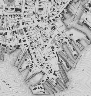
1834–35 Lithograph 24 x 38 in. Gloucester City Archives
"Drawn on a scale of one hundred feet to an inch. By John Mason 1834–45 from Actual Survey showing every Lott and building then standing on them giving the actual size of the buildings and width of the streets from the Canal to the head of the Harbour & part of Eastern point as farr as Smith's Cove and the Shore of the same with all the wharfs then in use. Gloucester Harbor 1834–35."
This map shows the location of F. E. Low's wharf and the ropewalk. Duncan's Point, the site where Lane would eventually build his studio, is also marked.
The later notes on the map are believed to be by Mason.
Also filed under: Gloucester Harbor, Inner / Harbor Cove » // Low (Frederick G.) wharves » // Low, Capt. Frederick Gilman » // Maps » // Mason, John » // Residences » // Ropewalk » // Somes, Capt. John »
44 x 34 in.
Henry Francis Walling, Map of the Towns of Gloucester and Rockport, Essex Co. Massachusetts. Philadelphia, A. Kollner, 1851
Cape Ann Museum Library & Archive
"Map of the Towns of Gloucester and Rockport, Massachusetts. H.F. Walling, Civil Engineer. John Hanson, Publisher. 1851. Population of Gloucester in 1850 7,805. Population of Rockport in 1850 3,213."
Segment of Harbor Village portion of map showing Lane-Winter property on Duncan's Point.
Also filed under: Maps » // Union School » // Winter, Ignatius »
Cape Ann Museum Library & Archive
Segment shows Lane's home on Duncan's Point (as F. G. Low property) and neighboring businesses about five years after his death.
Also filed under: Maps »
Mounted print
8 x 10 in.
Cape Ann Museum Library & Archive
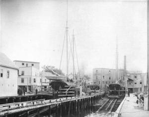
Railway at the tip of Duncan's Point. Vessels on the ways are "Isabell Leighton" and "Hattie B. West."
Also filed under: Burnham Brothers Marine Railway »

c.1870 Cape Ann Museum Library & Archive (2013.068)
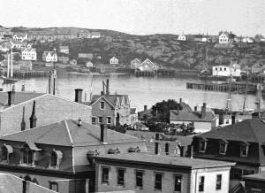
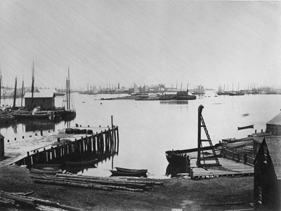
Schooner fleet anchored in the inner harbor. Looking east from Rocky Neck, Duncan's Point wharves and Lane house (at far left), Sawyer School cupola on Friend Street.
Also filed under: Gloucester Harbor, Inner / Harbor Cove » // Historic Photographs » // Schooner (Fishing) » // Waterfront, Gloucester »
Through the years, this point and its fortifications had many names: Watch House Point, the Old Battery, Fort Defiance, Fort Head, and now just "The Fort." In 1793, Fort Defiance was turned over to the young United States government and was allowed to deteriorate. During the War of 1812 it was described as being "in ruins," and any remaining buildings burned in 1833. It was resuscitated in the Civil War and two batteries of guns were installed. The City of Gloucester did not regain ownership of the land until 1925.
The first fortifications on this point, guarding the entrance to the Inner Harbor, were put up in the 1740s, when fear of attack from the French led to the construction of a battery armed with twelve-pounder guns. Greater breastworks were thrown up in 1775, after Capt. Lindsay and his sloop-of-war the "Falcon" attacked the unprepared town. They were small and housed only a few cannon and local soldiers. Several other fortifications were at various times erected around the harbor: Fort Conant at what is now Stage Fort Park, another on Duncan's Point (near site of Lane's house) and the Civil War fort on Eastern Point. None of these preparations was ever called upon to actually defend the town.
Lane during his lifetime created a long series of images of the point and the condition of its fortifications. In 1832 there were still buildings standing, and the point had not yet been used for major wharves and warehouses. By the time of his painting Gloucester Harbor, 1852 (inv. 38), one can see that the earthwork foundation, but no superstructures, survived.
– Sarah Dunlap

1860 In John J. Babson, History of the Town Gloucester (Gloucester, MA: Procter Brothers, 1860) Cape Ann Museum Library & Archives, Gloucester, Mass.
See p. 474.
View related catalogue entries (4) »
Also filed under: Babson History of the Town of Gloucester » // Chebacco Boat / Dogbody / Pinky » // Gloucester Harbor, Inner / Harbor Cove » // Gloucester, Mass. - "Ten Pound Island Light » // Schooner (Coasting / Lumber / Topsail / Packet / Marsh Hay) » // Ten Pound Island »
Newsprint
Gloucester Telegraph
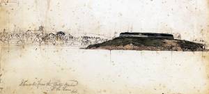
About picture of Old Fort hanging in the Gloucester Bank: "This picture is chiefly of interest on account of its preserving so accurately the features of a view so familiar to many of our citizens and which can never exist in reality."
Also filed under: Chronology » // Gloucester Bank » // Gloucester, Mass. – Gloucester Bank » // Newspaper / Journal Articles »
24 x 38 in.
Gloucester City Archives
"Drawn on a scale of one hundred feet to an inch. By John Mason 1834–45 from Actual Survey showing every Lott and building then standing on them giving the actual size of the buildings and width of the streets from the Canal to the head of the Harbour & part of Eastern point as farr as Smith's Cove and the Shore of the same with all the wharfs then in use. Gloucester Harbor 1834–35."
This map is especially useful in showing the Fort.
Also filed under: Flake Yard » // Maps » // Mason, John » // Pavilion (Publick) Beach » // Town / Public Landings »

44 x 34 in.
John Hanson, Publisher
Cape Ann Museum Library & Archive
"Map of the Towns of Gloucester and Rockport, Massachusetts. H.F. Walling, Civil Engineer. John Hanson, Publisher. 1851. Population of Gloucester in 1850 7,805. Population of Rockport in 1850 3,213."
Also filed under: Low (Frederick G.) wharves » // Maps » // Rogers's (George H.) wharves » // Town / Public Landings » // Waterfront, Gloucester » // Windmill »
Newsprint
Cape Ann Advertiser
Cape Ann Museum Library & Archive
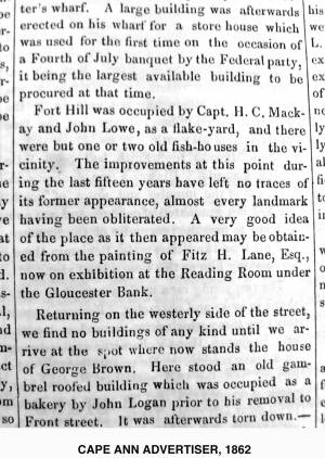
"Fort Hill was occupied by Capt. H. C. Mackay and John Lowe, as a flake-yard, and there were but one or two old fish-houses in the vicinity. The improvements at this point during the last fifteen years have left no traces of its former appearance, almost every landmark having been obliterated. A very good idea of the place as it then appeared may be obtained from the painting of Fitz H. Lane, Esq., now on exhibition at the Reading Room under the Gloucester Bank."
Also filed under: Gloucester Bank » // Newspaper / Journal Articles »
Newspaper
Gloucester Telegraph
"By the will of the late Fitz H. Lane, Esq., his handsome painting of the Old Fort, Ten Pound Island, etc., now on exhibition at the rooms of the Gloucester Maritime Insurance Co., was given to the town... It will occupy its present position until the town has a suitable place to receive it."
Also filed under: Funeral & Burial » // Gloucester, Mass. – Marine Insurance Company » // Newspaper / Journal Articles » // Ten Pound Island »
Newsprint
Gloucester Telegraph
At the dedication of the Town House, speaker, "read the following letter:
To the Selectmen of Gloucester: / Gents: The will of our late Townsman, Fitz. H. Lane, contains this provision: / I give to the inhabitants of the Town of Gloucester, the picture of the Old Fort, to be kept as a memento[sic] of one of the localities of olden time; the said picture now hanging in the Reading Room under the Gloucester Bank, and to be there kept until the Town of Gloucester shall furnish a suitable and safe place to hang it. / The original sketch was taken twenty-five years ago, but the boats and vessels introduced are those of a quarter of a century earlier still. The painting was executed in 1859, six years before his decease."
Also filed under: Documents / Objects » // Newspaper / Journal Articles » // Town House »

Stereograph card
Cape Ann Museum Library & Archive
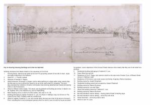
View from top of Unitarian Church on Middle Street looking southeast, showing the Fort and Ten Pound Island. Tappan Block and Main Street buildings between Center and Hancock in foreground.
Also filed under: Ten Pound Island » // Unitarian Church / First Parish Church (Middle Street) »

1876 Photograph Cape Ann Museum Library & Archive
Ignatius Weber's windmill (now defunct) is shown.
Also filed under: Flake Yard » // Gloucester Harbor, Inner / Harbor Cove » // Historic Photographs » // Rogers's (George H.) wharves » // Schooner (Fishing) » // Waterfront, Gloucester » // Windmill »
The northeast quarter of Gloucester Harbor is an inlet bounded by Fort Point and Rocky Neck at its entrance. It is further indented by three coves: Harbor Cove and Vincent’s Cove on its north side, and Smith’s Cove on its south side. The shallow northeast end is called Head of the Harbor. Collectively, this inlet with its coves and shallows is called Inner Harbor.
The entrance to Inner Harbor is a wide channel bounded by Fort Point and Duncan’s Point on its north side, and by Rocky Neck on its south side. From colonial times to the late nineteenth century, it was popularly known as “the Stream” and served as anchorage for deeply loaded vessels for “lightering” (partial off-loading). Subsequently it was known as “Deep Hole.”
Of Inner Harbor’s three coves, Harbor Cove (sometimes called “Old Harbor” in later years) was the deepest and most heavily used by fishing vessels in the Colonial Period, and largely dominated by the foreign trade in the first half of the nineteenth century. Its shallow bottom was the undoing of the foreign trade, as larger vessels became too deep to approach its wharves, and the cove returned to servicing a growing fishing fleet in the 1850s.
Vincent’s Cove, a smaller neighbor to Harbor Cove, was bare ground at low tide, and mostly useless for wharfage. Its shoreline was well suited for shipbuilding, and the cove was deep enough at high tide for launching. Records of shipbuilding there prior to the early 1860s have to date not been found.Smith’s Cove afforded wharfage for fishing vessels at its east entrance, as seen in Lane’s lithograph View of the Town of Gloucester, Mass., 1836 (inv. 86). The rest of the cove saw little use until the expansion of the fisheries after 1865.
The Head of the Harbor begins at the shallows surrounding Five Pound Island, extending to the harbor’s northeast end. Lane’s depiction of this area in Gloucester Harbor, 1847 (inv. 23) shows the problems faced by vessel owners at low tide. Despite the absence of deep water, this area saw rapid development after 1865 when a thriving fishing industry needed waterfront facilities, even if they were accessible only at high tide.
– Erik Ronnberg
c.1870 Cape Ann Museum Library & Archive (2013.068)
Schooner fleet anchored in the inner harbor. Looking east from Rocky Neck, Duncan's Point wharves and Lane house (at far left), Sawyer School cupola on Friend Street.
Also filed under: Duncan's Point » // Historic Photographs » // Schooner (Fishing) » // Waterfront, Gloucester »
1876 Photograph Cape Ann Museum Library & Archive
Also filed under: Historic Photographs » // Schooner (Fishing) » // Waterfront, Gloucester »
1851 44 x 34 in. Henry Francis Walling, Map of the Towns of Gloucester and Rockport, Essex Co. Massachusetts. Philadelphia, A. Kollner, 1851 Cape Ann Museum Library & Archive
"Map of the Towns of Gloucester and Rockport, Massachusetts. H.F. Walling, Civil Engineer. John Hanson, Printer. 1851. Population of Gloucester in 1850 7,805. Population of Rockport in 1850 3,213."
Also filed under: Baptist Church (Old, First, 1830) (Pleasant Street) » // Burnham Brothers Marine Railway » // Duncan's Point » // Five Pound Island » // Flake Yard » // Harbor Methodist Church (Prospect Street) » // Low (Frederick G.) wharves » // Pavilion Hotel » // Procter Brothers » // Ropewalk » // Vincent's Cove » // Western Shore »

4 x 6 in.
Cape Ann Museum, Benham Collection
George Steele sail loft, William Jones spar yard, visible across harbor. Photograph is taken from high point on the Fort, overlooking business buildings on the Harbor Cove side.
Also filed under: Fort (The) and Fort Point » // Town House » // Universalist Church (Middle and Church Streets) » // Waterfront, Gloucester »

1834–35 Lithograph 24 x 38 in. Gloucester City Archives
"Drawn on a scale of one hundred feet to an inch. By John Mason 1834–45 from Actual Survey showing every Lott and building then standing on them giving the actual size of the buildings and width of the streets from the Canal to the head of the Harbour & part of Eastern point as farr as Smith's Cove and the Shore of the same with all the wharfs then in use. Gloucester Harbor 1834–35."
This map shows the location of F. E. Low's wharf and the ropewalk. Duncan's Point, the site where Lane would eventually build his studio, is also marked.
The later notes on the map are believed to be by Mason.
Also filed under: Duncan's Point » // Low (Frederick G.) wharves » // Low, Capt. Frederick Gilman » // Maps » // Mason, John » // Residences » // Ropewalk » // Somes, Capt. John »
44 x 34 in.
Henry Francis Walling, Map of the Towns of Gloucester and Rockport, Essex Co. Massachusetts. Philadelphia, A. Kollner, 1851
Cape Ann Museum Library & Archive
"Map of the Towns of Gloucester and Rockport, Massachusetts. H.F. Walling, Civil Engineer. John Hanson, Publisher. 1851. Population of Gloucester in 1850 7,805. Population of Rockport in 1850 3,213."
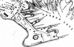
Segment of Harbor Village portion of map showing Collins' and other wharves in the Inner Harbor.
Also filed under: Graving Beach »

Collection of Erik Ronnberg
View related catalogue entries (2) »
Also filed under: Dolliver's Neck » // Fresh Water Cove » // Gloucester Harbor, Outer » // Maps »

1865 41 x 29 inches Courtesy of the Massachusetts Archives Maps and Plans, Third Series Maps, v.66:p.1, no. 2352, SC1/series 50X
.
Also filed under: Burnham Brothers Marine Railway » // Collins's, William (estate wharf) » // Maps » // Rogers's (George H.) wharves »
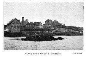
Photograph in The Illustrated Coast Pilot with Sailing Directions. The Coast of New England from New York to Eastport, Maine including Bays and Harbors, published by N. L. Stebbins, Boston
Also filed under: Beacons / Monuments / Spindles »
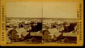
Stereograph card Cape Ann Museum Library & Archive
Also filed under: Gloucester – City Views » // Historic Photographs »
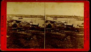
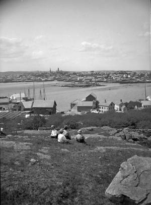
c.1870s Stereograph card Cape Ann Museum Library & Archive
From East Gloucester looking towards Gloucester.
Also filed under: Gloucester – City Views » // Historic Photographs »
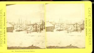
1876 Stereograph card Cape Ann Museum Library & Archive
Stereo view showing Gloucester Harbor after a heavy snowfall
Also filed under: Historic Photographs » // Waterfront, Gloucester »
Cape Ann Museum Library & Archive
Five Pound Island and Gloucester inner harbor taken from the top of Hammond Street building signs in foreground are for Severance, Carpenter and Crane, and Cooper at Clay Cove.
Also filed under: Five Pound Island »
1852
Oil on canvas
28 x 48 1/2 in.
Cape Ann Museum, Gloucester, Mass., Deposited by the City of Gloucester, 1952. Given to the city by Mrs. Julian James in memory of her grandfather Sidney Mason, 1913 (DEP. 200)
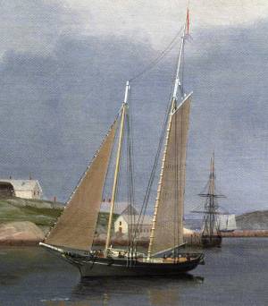
Detail of fishing schooner.
Also filed under: Schooner (Fishing) »
Oil on canvas
34 x 45 3/4 in.
Cape Ann Museum, Gloucester, Mass., Gift of Mrs. Jane Parker Stacy (Mrs. George O. Stacy),1948 (1289.1a)
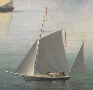
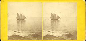
Detail of party boat.
Also filed under: Party Boat »
c.1869 Glass plate negative Cape Ann Museum Library & Archive Detail from CAHA#00279
The magnificent views of Gloucester Harbor and the islands from the top floor of the stone house at Duncan's Point where Lane had his studio were the inspiration for many of his paintings.
From Buck and Dunlop, Fitz Henry Lane: Family, and Friends, pp. 59–74.
Also filed under: Duncan's Point » // Lane's Stone House, Duncan's Point » // Residences »
Glass plate negative
3 x 4 in.
Cape Ann Museum Library & Archive
#10112
Also filed under: Chebacco Boat / Dogbody / Pinky »
1876 Photograph Cape Ann Museum Library & Archive
Ignatius Weber's windmill (now defunct) is shown.
Also filed under: Flake Yard » // Fort (The) and Fort Point » // Historic Photographs » // Rogers's (George H.) wharves » // Schooner (Fishing) » // Waterfront, Gloucester » // Windmill »
1860 In John J. Babson, History of the Town Gloucester (Gloucester, MA: Procter Brothers, 1860) Cape Ann Museum Library & Archives, Gloucester, Mass.
See p. 474.
View related catalogue entries (4) »
Also filed under: Babson History of the Town of Gloucester » // Chebacco Boat / Dogbody / Pinky » // Fort (The) and Fort Point » // Gloucester, Mass. - "Ten Pound Island Light » // Schooner (Coasting / Lumber / Topsail / Packet / Marsh Hay) » // Ten Pound Island »
Ten Pound Island guards the entrance to Gloucester’s Inner Harbor and provides a crucial block to heavy seas running southerly down the Outer Harbor from the open ocean beyond. The rocky island and its welcoming lighthouse is seen, passed, and possibly blessed by every mariner entering the safety of Gloucester’s Inner Harbor after outrunning a storm at sea. Ten Pound Island is situated such that the Inner Harbor is protected from open water on all sides making it one of the safest harbors in all New England.
Legend has it that the island was named for the ten pound sum paid to the Indians for the island, and the smaller Five Pound Island deeper in the Inner Harbor was purchased for that lesser sum. None of it makes much financial sense when the entirety of Cape Ann was purchased for only seven pounds from the Indian Samuel English, grandson of Masshanomett the Sagamore of Agawam in 1700. From approximately 1640 on the island was used to hold rams, and anyone putting female sheep on the island was fined. Gloucester historian Joseph Garland has posited that the name actually came from the number of sheep pens it held, or pounds as they were called, and the smaller Five Pound Island was similarly named.
The island itself is only a few acres of rock and struggling vegetation but is central to the marine life of the harbor as it defines the eastern edge of the deep channel used to turn the corner and enter the Inner Harbor. The first lighthouse was lit there in 1821, and a house was built for the keeper adjacent to the lighthouse.
In the summer of 1880 Winslow Homer boarded with the lighthouse keeper and painted some of his most masterful and evocative watercolor views of the busy harbor life swirling about the island at all times of day. Boys rowing dories, schooners tacking in and out in all weather, pleasure craft drifting in becalmed water, seen together they tell a Gloucester story of light, water and sail much as Lane’s work did only several decades earlier.

Colored lithograph
Cape Ann Museum Library and Archive
Also filed under: Gloucester, Mass. - "Ten Pound Island Light »

Photograph
From The Illustrated Coast Pilot with Sailing Directions. The Coast of New England from New York to Eastport, Maine including Bays and Harbors, N. L. Stebbins, 1891.
Also filed under: Gloucester, Mass. - "Ten Pound Island Light »


Oil on canvas
22 x 36 in.
Cape Ann Museum, Gloucester, Mass., deposited by the Collection of Addison Gilbert Hospital, 1978 (DEP. 201)
Detail of party boat.
Also filed under: Party Boat »

Engraving of 1819 survey taken from American Coast Pilot 14th edition
9 1/2 x 8 in.
Cape Ann Museum Library & Archive
D32 FF5
Also filed under: Dolliver's Neck » // Eastern Point » // Maps » // Norman's Woe »
Newspaper
Gloucester Telegraph
"By the will of the late Fitz H. Lane, Esq., his handsome painting of the Old Fort, Ten Pound Island, etc., now on exhibition at the rooms of the Gloucester Maritime Insurance Co., was given to the town... It will occupy its present position until the town has a suitable place to receive it."
Stereograph card
Cape Ann Museum Library & Archive
View from top of Unitarian Church on Middle Street looking southeast, showing the Fort and Ten Pound Island. Tappan Block and Main Street buildings between Center and Hancock in foreground.
Also filed under: Fort (The) and Fort Point » // Unitarian Church / First Parish Church (Middle Street) »
1860 In John J. Babson, History of the Town Gloucester (Gloucester, MA: Procter Brothers, 1860) Cape Ann Museum Library & Archives, Gloucester, Mass.
See p. 474.
View related catalogue entries (4) »
Also filed under: Babson History of the Town of Gloucester » // Chebacco Boat / Dogbody / Pinky » // Fort (The) and Fort Point » // Gloucester Harbor, Inner / Harbor Cove » // Gloucester, Mass. - "Ten Pound Island Light » // Schooner (Coasting / Lumber / Topsail / Packet / Marsh Hay) »
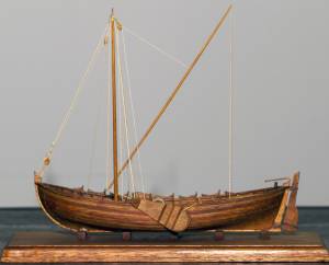
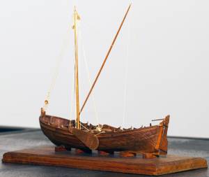
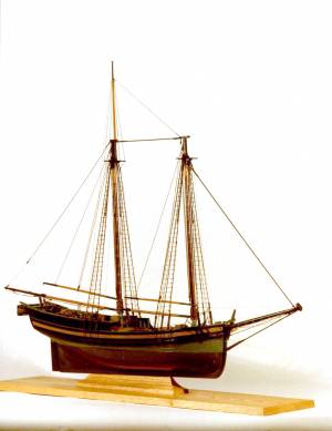
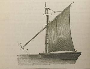
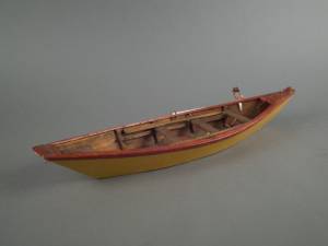
The colonial American shallop is the ancestor of many regional types of New England fishing craft found in Lane's paintings and drawings, including "New England Boats" (known as "boats"), and later descendents, such as "Chebacco Boats," "Dogbodies," and "Pinkies." (discussed elsewhere)
These boats were very common work boat types on Cape Ann throughout the 1800s. They were primarily used for inshore coastal fishing, which included lobstering, gill-netting, fish-trapping, hand-lining, and the like. They were usually sailed by one or two men, sometimes with a boy, and could be rowed as well as sailed. An ordinary catch would include rock cod, flounder, fluke, dabs, or other small flat fish. The catch would be eaten fresh, or salted and stored for later consumption, or used as bait fish. Gill-netting would catch herring and alewives when spawning. Wooden lobster traps were marked with buoys much as they are today, and hauled over the low sides of the boat, emptied of lobsters and any by-catch, re-baited and thrown back.
THE SHALLOP
Like other colonial vessel types, shallops were defined in many ways, including size, construction, and rig. Most commonly, they were open boats with square or sharp sterns, 20 to 30 feet in length, two-masted rigs, and heavy sawnframe construction which in time became lighter. (1)
The smaller shallops developed into a type called the Hampton Boat early in the nineteenth century, becoming the earliest named regional variant of what is now collectively termed the New England Boat. Other variants were named for their regions of origin: Isles of Shoals Boat, Casco Bay Boat, No Mans Land Boat, to name a few. No regional name for a Cape Ann version has survived, and "boat," or "two-masted boat" seems to have sufficed. (2)
Gloucester's New England Boats were mostly double-enders (sharp sterns) ranging in length from 25 to 30 feet, with two masts and two sails (no bowsprit or jib). They were used in the shore fisheries: handlining, gillnetting, and gathering or trapping shellfish (see View from Kettle Cove, Manchester-by-the-Sea, 1847 (inv. 94), View of Gloucester Harbor, 1848 (inv. 97), and /entry: 240/). (3)
Larger, double-ended shallops became decked and evolved in Ipswich (the part now called Essex) to become Chebacco Boats. (4) This variant retained the two-mast, two-sail rig, but evolved further, acquiring a bowsprit and jib and becoming known as a pinky (see Gloucester Harbor from Rocky Neck, 1844 (inv. 14), The Western Shore with Norman's Woe, 1862 (inv. 18), and The Old Fort and Ten Pound Island, Gloucester, 1850s (inv. 30)). The Chebacco Boat became a distinct type by the mid-eighteenth century giving rise to the pinky in the early ninetennth century; the latter, by the early 1900s. (5)
References:
1. William A. Baker, Sloops & Shallops (Barre, MA: Barre Publishing Co., 1966), 27–33; and “Vessel Types of Colonial Massachusetts,” in Seafaring in Colonial Massachusetts (Boston: The Colonial Society of Massachusetts, 1980), 13–15, see figs. 10, 11.
2. Howard I. Chapelle, American Small Sailing Craft (New York: W.W. Norton & Co., 1951), 136–45.
3. Ibid., 145, upper photo, fourth page of plates.
4. Baker, 82–91.
5. Chapelle, The American Fishing Schooners, 1825–1935 (New York: W.W. Norton & Co., 1973), 23–54.
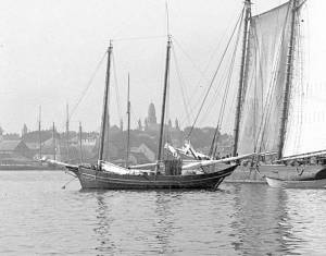
THE NEW ENGLAND BOAT
By the 1840s, the Gloucester version of the New England Boat had evolved into a distinct regional type. Referred to locally as “boats,” the most common version was a double-ender, i.e. having a pointed stern, unlike the less common version having a square stern.
Both variants had two masts, a foresail, a mainsail, but no bowsprit or jib. Lane depicted both in several paintings, beginning in the mid-1840s (see View from Kettle Cove, Manchester-by-the-Sea, 1847 (inv. 94), View of Gloucester Harbor, 1848 (inv. 97), and /entry: 240/), all ranging 25 to 30 feet in length. In View of Gloucester Harbor, 1848 (inv. 97) and Gloucester Inner Harbor, 1850 (inv. 240), a double-ender can be seen on the beach while a square-stern version lies at anchor in the harbor, just to the right of the former. (1)
Lane’s depictions of the double-enders show lapstrake hull planking in View of Gloucester Harbor, 1848 (inv. 97) and Gloucester Inner Harbor, 1850 (inv. 240), and cuddies (short decking) inboard at the ends for shelter and stowage of fishing gear in View from Kettle Cove, Manchester-by-the-Sea, 1847 (inv. 94). The few square-stern examples (see View of Gloucester Harbor, 1848 (inv. 97) and Gloucester Inner Harbor, 1850 (inv. 240)) suggest carvel (smooth) planking and paint finish, rather than oil and tar. The presence of an example of the latter variant in Boston Harbor, as noted in Boston Harbor, c.1850 (inv. 48), suggests a broader geographical range for this subtype. (2)
The primary use of Cape Ann’s “boats” was fishing, making “day trips” to coastal grounds for cod, herring, mackerel, hake, flounder, and lobster, depending on the season. Fishing gear included hooks and lines, gill nets, and various traps made of wood and fish net.
Some boats worked out of Gloucester Harbor, but other communities on Cape Ann had larger fleets, such as Sandy Bay, Pigeon Cove, Folly Cove, Lanesville, Bay View, and Annisquam. Lane’s depictions of these places and their boats are rare to nonexistent. (3)
The double-ended boat served Lane in marking the passage of time in Gloucester Harbor. In View from Kettle Cove, Manchester-by-the-Sea, 1847 (inv. 94), we see new boats setting out to fish, but in View of Gloucester Harbor, 1848 (inv. 97) and Gloucester Inner Harbor, 1850 (inv. 240), a boat of the same type is depicted in a progressively worn state. In Stage Fort across Gloucester Harbor, 1862 (inv. 237), the boat is a stove hulk on a beach, and in the same year, Lane depicted the type’s shattered bottom frame and planking lying on the shore at Norman’s Woe in Norman's Woe, Gloucester Harbor, 1862 (inv. 1).
Regional variants of the New England Boat appear in Lane’s paintings of Maine harbors, including one and two-masted versions, collectively called Hampton Boats (see Bear Island, Northeast Harbor, 1855 (inv. 24), Ten Pound Island at Sunset, 1851 (inv. 25), Fishing Party, 1850 (inv. 50), Father's (Steven's) Old Boat, 1851 (inv. 190), and "General Gates" at Anchor off Our Encampment at Bar Island in Somes Sound, Mount Desert, Maine, 1850 (inv. 192)). Some distinctive regional types were given names, i.e. Casco Bay Boats ("General Gates" at Anchor off Our Encampment at Bar Island in Somes Sound, Mount Desert, Maine, 1850 (inv. 192) may be one), but many local type names, if they were coined, have been lost. (4)
References:
1. Howard I. Chapelle, American Small Sailing Craft (New York: W.W. Norton & Co., 1951), 141–42.
2. Ibid., 152–55.
3. Sylvanus Smith, Fisheries of Cape Ann (Gloucester, MA: Press of the Gloucester Times, 1915), 96–97, 102–05, 110–13.
4. Chapelle, 152–55.
Also filed under: Ship Models »
Also filed under: Ship Models »
"Party boat" is a colloquial term for any kind of small craft adapted or used for taking guests (customarily for hire) on sightseeing trips or fishing for pleasure. (1) The term survives to this day on Cape Ann and other places for vessels engaged in the same activities. (2) In Lane's time, party boating was a calling of opportunity, and a fisherman's boat might be used in season - regularly or occasionally - to take "rusticators" fishing. Likewise, a boat used for its owner's own pleasure might be hired to take sightseers sailing for an afternoon. The latter use is seen in Lane's 1844 view of Gloucester Harbor from Rocky Neck (see the yawl-rigged sailboat in the foreground of Gloucester Harbor from Rocky Neck, 1844 (inv. 14)).
By the early 1850s, summer visitor activity, encouraged by the building of the Pavilion Hotel on Gloucester's waterfront, led to increased pleasure boating activity, if Lane's painting Gloucester Harbor, 1852 (inv. 38) of Pavilion Beach and Sidney Mason's hotel is any indication. (3) Lane's Gloucester Harbor scenes from this decade show a number of pleasure craft suitable for taking passengers for hire (see Fresh Water Cove from Dolliver's Neck, Gloucester, Early 1850s (inv. 45), Coming Ashore near Brace's Rock, Gloucester, Massachusetts, c.1860 (inv. 60), and View of Gloucester from "Brookbank," the Sawyer Homestead, c.1856 (inv. 95)). Small working craft suitable for this purpose are seen in The Old Fort and Ten Pound Island, Gloucester, 1850s (inv. 30), Gloucester Harbor, 1852 (inv. 38) (right foreground), View of Gloucester, 1859 (inv. 91) (foreground), and Watch House Point, 1860 (inv. 292) (right foreground). In View of Gloucester Harbor, 1848 (inv. 97), we see passengers boarding a small sloop-rigged boat hidden by the rocks at Duncan's Point (left middle ground).
In coastal waters south of Gloucester, a few of Lane's paintings offer pleasure craft as candidates for taking paying passengers. Phantom of Boston, c.1850s (inv. 574) depicts a cruising yawl "Phantom" of Boston, beached with hunting gear unloaded alongside while two of the crew await an approaching party in a rowing boat. The location is unidentified, but a possibility is the barrier beach around the marshes of Lynn, Massachusetts, which were once very popular hunting grounds for migrating waterfowl. A second candidate is a small sloop with a party of four on an evening sail off Halfway Rock in Becalmed Off Halfway Rock, 1860 (inv. 344) (far right).
Lane found similar uses of working watercraft in Maine, where the families of a small coastal community would travel by their workboats to a gathering place for a clambake or similar festive outing (see View of Indian Bar Cove, Brooksville, Maine, 1850 (inv. 61)). The artist became a "rusticator" himself when he, Joseph Stevens, and friends explored Mount Desert Island and vicinity in the "General Gates," a sloop-rigged Maine version of a New England Boat (View of Bar Island and Mount Desert Mountains, from the Bay in Front of Somes Settlement, 1850 (inv. 177) and Castine Harbor and Town, 1851 (inv. 272)).
When Lane traveled to New Bedford in 1856 to observe and sketch a regatta held by the New York Yacht Club, he observed and sketched it while on board an unknown vessel near the starting and finishing line, formed by the race committee boat "Emblem" and her yawl-boat.
Close by was a small party boat with observers on board, probably a fishing sloop, given its work-a-day looks. In the ensuing year, Lane painted four detailed views of this race, the party boat appearing in New York Yacht Club Regatta (1), 1856 (inv. 66) (right foreground); New York Yacht Club Regatta (2), 1856 (inv. 270) (right margin); New York Yacht Club Regatta (3), After 1856 (inv. 396) (center); and New York Yacht Club Regatta (4), 1857 (inv. 397) (left foreground). (4)
– Erik Ronnberg
References:
1. M. H. Parry and others, Aak to Zumbra: A Dictionary of the World's Watercraft (Newport News, VA: The Mariners' Museum, 2000), 436.
2. Ibid.
3. Proctor's Able Sheet (a Gloucester newspaper), January 1857: "Gloucester House reopened—refitted—boats always ready to take parties cruising or fishing..."
4. John Wilmerding, Fitz Henry Lane, 2nd ed. (Cape Ann, MA: Cape Ann Historical Association, 2005), 52–54. Lane's 1852 cruise in the Mount Desert region in the sloop "Superior" was reprinted as an appendix to Wilmerding's essay in Paintings by Fitz Hugh Lane (Washington, DC: National Gallery of Art, 1988), 125–26.
Oil on canvas
34 x 45 3/4 in.
Cape Ann Museum, Gloucester, Mass., Gift of Mrs. Jane Parker Stacy (Mrs. George O. Stacy),1948 (1289.1a)
Detail of party boat.
Also filed under: Gloucester Harbor, Inner / Harbor Cove »
Oil on canvas
22 x 36 in.
Cape Ann Museum, Gloucester, Mass., deposited by the Collection of Addison Gilbert Hospital, 1978 (DEP. 201)
Detail of party boat.
Also filed under: Ten Pound Island »
Newspaper
Ad in Gloucester Telegraph
FISHING AND SAILING PARTIES
"Persons desirous of enjoying a SAILING or FISHING EXCURSION, are informed that the subscriber will be in readiness with the Boat EUREKA, to attend to all who may favor him with their patronage. JOHN J. FERSON"
Also filed under: Gloucester Harbor – Use » // Newspaper / Journal Articles »
Newsprint
Ad for Gloucester House
Courtesy of the American Antiquarian Society, Worcester, Mass.
See p. 4, column 2.
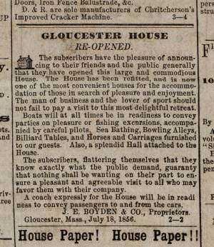
Also filed under: Brick Houses / Gloucester House Hotel » // Newspaper / Journal Articles »
Schooners in Lane’s time were, with few exceptions, two-masted vessels carrying a fore-and-aft rig having one or two jibs, a fore staysail, gaff-rigged fore- and main sails, and often fore- and main topsails. One variant was the topsail schooner, which set a square topsail on the fore topmast. The hulls of both types were basically similar, their rigs having been chosen for sailing close to the wind. This was an advantage in the coastal trade, where entering confined ports required sailing into the wind and frequent tacking. The square topsail proved useful on longer coastwise voyages, the topsail providing a steadier motion in offshore swells, reducing wear and tear on canvas from the slatting of the fore-and-aft sails. (1)
Schooners of the types portrayed by Lane varied in size from 70 to 100 feet on deck. Their weight was never determined, and the term “tonnage” was a figure derived from a formula which assigned an approximation of hull volume for purposes of imposing duties (port taxes) oncargoes and other official levies. (2)
Crews of smaller schooners numbered three or four men. Larger schooners might carry four to six if a lengthy voyage was planned. The relative simplicity of the rig made sail handling much easier than on a square-rigged vessel. Schooner captains often owned shares in their vessels, but most schooners were majority-owned by land-based firms or by individuals who had the time and business connections to manage the tasks of acquiring and distributing the goods to be carried. (3)
Many schooners were informally “classified” by the nature of their work or the cargoes they carried, the terminology coined by their owners, agents, and crews—even sometimes by casual bystanders. In Lane’s lifetime, the following terms were commonly used for the schooner types he portrayed:
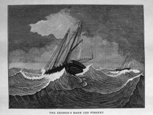
Fishing Schooners: While the port of Gloucester is synonymous with fishing and the schooner rig, Lane depicted only a few examples of fishing schooners in a Gloucester setting. Lane’s early years coincided with the preeminence of Gloucester’s foreign trade, which dominated the harbor while fishing was carried on from other Cape Ann communities under far less prosperous conditions than later. Only by the early 1850s was there a re-ascendency of the fishing industry in Gloucester Harbor, documented in a few of Lane’s paintings and lithographs. Depictions of fishing schooners at sea and at work are likewise few. Only A Smart Blow, c.1856 (inv. 9), showing cod fishing on Georges Bank (4), and At the Fishing Grounds, 1851 (inv. 276), showing mackerel jigging on Georges Bank, are known examples. (5)
– Erik Ronnberg
References:
1. Howard I. Chapelle, The History of American Sailing Ships (New York: W.W. Norton & Co., 1935), 258. While three-masted schooners were in use in Lane’s time, none have appeared in his surviving work; and Charles S. Morgan, “New England Coasting Schooners”, The American Neptune 23, no. 1 (DATE): 5–9, from an article which deals mostly with later and larger schooner types.
2. John Lyman, “Register Tonnage and its Measurement”, The American Neptune V, nos. 3–4 (DATE). American tonnage laws in force in Lane’s lifetime are discussed in no. 3, pp. 226–27 and no. 4, p. 322.
3. Ship Registers of the District of Gloucester, Massachusetts, 1789–1875 (Salem, MA: The Essex Institute, 1944). Vessels whose shipping or fishing voyages included visits to foreign ports were required to register with the Federal Customs agent at their home port. While the vessel’s trade or work was unrecorded, their owners and master were listed, in addition to registry dimensions and place where built. Records kept by the National Archives can be consulted for information on specific voyages and ports visited.
4. Howard I. Chapelle, The National Watercraft Collection (Washington, DC: Smithsonian Institution, 1960), 74–76.
5. Howard I. Chapelle, The American Fishing Schooners (New York: W.W. Norton & Co., 1973), 58–75, 76–101.
1852
Oil on canvas
28 x 48 1/2 in.
Cape Ann Museum, Gloucester, Mass., Deposited by the City of Gloucester, 1952. Given to the city by Mrs. Julian James in memory of her grandfather Sidney Mason, 1913 (DEP. 200)
Detail of fishing schooner.
Also filed under: Gloucester Harbor, Inner / Harbor Cove »
c.1865 Stereograph card Frank Rowell, Publisher stereo image, "x " on card, "x" Cape Ann Museum Library & Archive
View showing a sharpshooter fishing schooner, circa 1850. Note the stern davits for a yawl boat, which is being towed astern in this view.
Also filed under: Historic Photographs »
Model made for marine artist Thomas M. Hoyne
scale: 3/8" = 1'
Thomas M. Hoyne Collection, Mystic Seaport, Conn.
While this model was built to represent a typical Marblehead fishing schooner of the early nineteenth century, it has the basic characteristics of other banks fishing schooners of that region and period: a sharper bow below the waterline and a generally more sea-kindly hull form, a high quarter deck, and a yawl-boat on stern davits.
The simple schooner rig could be fitted with a fore topmast and square topsail for making winter trading voyages to the West Indies. The yawl boat was often put ashore and a "moses boat" shipped on the stern davits for bringing barrels of rum and molasses from a beach to the schooner.
– Erik Ronnberg
References:
Jeffrey Bolster, Black Jacks: African American Seafarers in the Age of Sail (Cambridge, MA: Harvard University Press, 1997).
Howard I. Chapelle, American Small Sailing Craft (New York: W.W. Norton & Co., 1951), 29–31.
Also filed under: Hand-lining » // Ship Models »

20 x 14 in.
Cape Ann Museum Library & Archive, Gloucester, Mass.
The image, as originally drafted, showed only spars and sail outlines with dimensions, and an approximate deck line. The hull is a complete overdrawing, in fine pencil lines with varied shading, all agreeing closely with Lane's drawing style and depiction of water. Fishing schooners very similar to this one can be seen in his painting /entry:240/.
– Erik Ronnberg
Newspaper
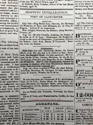
"Shipping Intelligence: Port of Gloucester"
"Fishermen . . . The T. [Tasso] was considerably injured by coming in contact with brig Deposite, at Salem . . ."
Also filed under: Newspaper / Journal Articles »
Newsprint
From bound volume owned by publisher Francis Procter
Collection of Fred and Stephanie Buck
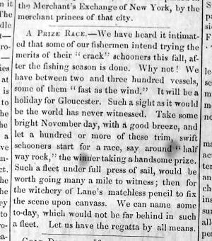
"A Prize Race—We have heard it intimated that some of our fishermen intend trying the merits of their "crack" schooners this fall, after the fishing season is done. Why not! . . .Such a fleet under full press of sail, would be worth going many a mile to witness; then for the witchery of Lane's matchless pencil to fix the scene upon canvass. . ."
Also filed under: Fishing » // Newspaper / Journal Articles »
Also filed under: Cape Ann Advertiser Masthead »

c.1870 Stereograph card Procter Brothers, Publisher Cape Ann Museum Library & Archive
"Gloucester Harbor from Rocky Neck, Looking Southwest. This gives a portion of the Harbor lying between Ten Pound Island and Eastern Point. At the time of taking this picture the wind was from the northeast, and a large fleet of fishing and other vessels were in the harbor. In the range of the picture about one hundred vessels were at anchor. In the small Cove in the foreground quite a number of dories are moored. Eastern Point appears on the left in the background."
Southeast Harbor was known for being a safe harbor.
Also filed under: Gloucester Harbor, Outer » // Historic Photographs » // Rocky Neck » // Small Craft – Wherries, and Dories »
1870s Stereograph card Cape Ann Museum Library & Archive
"Said schooner was captured about the first of September, 1871, by Capt. Torry, of the Dominion Cutter 'Sweepstakes,' for alleged violation of the Fishery Treaty. She was gallantly recaptured from the harbor of Guysboro, N.S., by Capt. Harvey Knowlton., Jr., (one of her owners,) assisted by six brave seamen, on Sunday night, Oct. 8th. The Dominion Government never asked for her return, and the United States Government very readily granted her a new set of papers."
Also filed under: Fishing » // Historic Photographs » // Waterfront, Gloucester »
1876 Photograph Cape Ann Museum Library & Archive
Also filed under: Gloucester Harbor, Inner / Harbor Cove » // Historic Photographs » // Waterfront, Gloucester »
c.1870 Cape Ann Museum Library & Archive (2013.068)
Schooner fleet anchored in the inner harbor. Looking east from Rocky Neck, Duncan's Point wharves and Lane house (at far left), Sawyer School cupola on Friend Street.
Also filed under: Duncan's Point » // Gloucester Harbor, Inner / Harbor Cove » // Historic Photographs » // Waterfront, Gloucester »
See p. 254.
As Erik Ronnberg has noted, Lane's engraving follows closely the French publication, Jal's "Glossaire Nautique" of 1848.
Also filed under: Babson History of the Town of Gloucester »
Wood, cordage, acrylic paste, metal
~40 in. x 30 in.
Erik Ronnberg
Model shows mast of fishing vessel being unstepped.
Also filed under: Burnham Brothers Marine Railway » // Fishing »


Watercolor on paper
8 3/4 x 19 3/4 in.
Cape Ann Museum, Gloucester, Mass., Gift of Rev. and Mrs. A. A. Madsen, 1950
Accession # 1468
Fishing schooners in Gloucester's outer harbor, probably riding out bad weather.
Also filed under: Elwell, D. Jerome » // Gloucester Harbor, Outer »
1876 Photograph Cape Ann Museum Library & Archive
Ignatius Weber's windmill (now defunct) is shown.
Also filed under: Flake Yard » // Fort (The) and Fort Point » // Gloucester Harbor, Inner / Harbor Cove » // Historic Photographs » // Rogers's (George H.) wharves » // Waterfront, Gloucester » // Windmill »
Print from bound volume of Gloucester scenes sent to the Philadelphia Centennial Exhibition.
11 x 14 in.
Cape Ann Museum Library & Archives
Schooner "Grace L. Fears" at David A. Story Yard in Vincent's Cove.
Also filed under: Historic Photographs » // Shipbuilding / Repair » // Vincent's Cove »
The term “wherry”—variously spelled—has a long history with many hull types, some dating from the fifteenth century. (1) The version known to Lane appears to be a variant of the dory hull form and probably was developed by French and English fishermen in the Newfoundland fisheries before 1700. (2) From that time, the wherry and the dory co-evolved, their similarities the result of their construction, their differences the result of use. By the early nineteenth century, their forms reached their final states, if fragments of contemporary descriptions are any indication. (3)
By the time Lane was depicting wherries, the type (as used for fishing) resembled a larger, wider version of a dory. The extra width was due to greater bottom width (both types had flat bottoms), with a wider transom at the stern instead of the narrow, v-shaped “tombstone.” These features are easy to see in one of his drawings (see Three Men, One in a Wherry, n.d. (inv. 225)) and a painting (see Sunrise through Mist, 1852 (inv. 98)), the latter depicted alongside a dory, clearly showing the differences.
No published descriptions of the uses of wherries on Cape Ann in Lane’s time have come to light, but an example in broadside view offers one use. In Becalmed Off Halfway Rock, 1860 (inv. 344), a pinky (in right foreground) has a dory and a wherry in tow, the latter loaded with a gill net for catching mackerel. (4) The greater size of the wherry is required for stowing the net, as well as setting it while the dory tows away one end to set it in way of the mackerel school.
In Lane’s time, wherries would have been used where bulky gear was called for in the coastal fisheries, i.e. gill nets, and fish traps such as pound nets, fyke nets, and lobster traps. Migrating fish schools (herring, mackerel) and shellfish were the target species.
The dory’s development was first dictated by its use in shore fishing, where small size and light weight made it easy to maneuver around rocks and shallows, and to haul ashore at the end of a day’s work. Its simple design made it easy and cheap to build. This is borne out by the standardized construction and sizes used by Simon Lowell’s boat shop at Salisbury Point, Massachusetts at the turn of the nineteenth century. Lowell called his boats “wherries,” but in Swampscott, Massachusetts, the fishermen, who used them called them “dories,” which may mark the beginning of the latter term’s wider use. (5)
The dories we see in Lane’s paintings are in virtually every way like the ones we know today. One of the best examples (see View from Kettle Cove, Manchester-by-the-Sea, 1847 (inv. 94)) even shows interior detail, including frames, leaving no doubt about its construction. Other good examples are found in Salem Harbor, 1853 (inv. 53), View of Gloucester Harbor, 1848 (inv. 97), and Sunrise through Mist, 1852 (inv. 98).
For inshore fishing, dories were used to catch mackerel and herring, either with hook and line or with small nets. Hooks and line were used for flat fish (flounder, dab, and fluke), rock cod, hake, and cunner. Eels were speared (see View from Kettle Cove, Manchester-by-the-Sea, 1847 (inv. 94)), clams were dug, and lobsters trapped. In Lane’s later years, the use of dories in trawling (setting long “trawl lines” with many baited hooks) was in its earliest. This method required six to ten dories carried on board a schooner to fish on the distant banks off New England and Canada. Early records of dory trawling in New England are fragmentary, giving the mid-1840s as the time of introduction. (6) The Gloucester-owned schooner "Anna" made a successful dory trawling trip to the Grand Banks in 1854, but no depiction of this vessel by Lane has been found or recorded. (5) Despite successful early efforts, dory trawling from Gloucester was slow to be accepted, and the fishery had very limited growth prior to 1860. (7)
– Erik Ronnberg
References:
1. M.H. Parry et al., Aak to Zumbra (Newport News, VA: The Mariners’ Museum, 2000), 634.
2. John Gardner, The Dory Book (Camden, ME: International Marine Publishing Company, 1978), 5–9.
3. Ibid., 25–29.
4. John Wilmerding, ed., Paintings by Fitz Hugh Lane (Washington, DC: National Gallery of Art, 1988), 89, 92. The “possibly discarded whaleboat” is definitely a wherry.
5. Gardner, 9, 10.
6. Wesley George Pierce, Goin’ Fishin’ (Salem, MA: Marine Research Society, 1934), 63–64.
7. Raymond McFarland, A History of New England Fisheries (Philadelphia: University of Pennsylvania, 1911), 279.
c.1870 Stereograph card Procter Brothers, Publisher Cape Ann Museum Library & Archive
"Gloucester Harbor from Rocky Neck, Looking Southwest. This gives a portion of the Harbor lying between Ten Pound Island and Eastern Point. At the time of taking this picture the wind was from the northeast, and a large fleet of fishing and other vessels were in the harbor. In the range of the picture about one hundred vessels were at anchor. In the small Cove in the foreground quite a number of dories are moored. Eastern Point appears on the left in the background."
Southeast Harbor was known for being a safe harbor.
Also filed under: Gloucester Harbor, Outer » // Historic Photographs » // Rocky Neck » // Schooner (Fishing) »
Also filed under: Chebacco Boat / Dogbody / Pinky » // Ship Models »
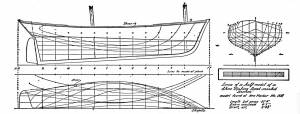
Gloucester, MA
4 x 33 1/2 x 7 1/4 in (10.16 x 85.09 x 18.415 cm)
Peabody Essex Museum
Also filed under: Objects » // Ship Models »
The Ten Pound Island light was built on a three-and-a-half acre island at the eastern end of Gloucester Harbor. Built as a conical stone tower, the original 20-foot-tall Ten Pound Island Light was first lit in October, 1821 after the Commonwealth of Massachusetts and the Town of Gloucester ceded 1.7 acres to the U.S. Government for the construction of an inner harbor lighthouse to help mariners navigate the harbor. Ten Pound Island light was a popular subject with artists, including Winslow Homer, who boarded with the lighthouse keeper at Ten Pound Island in the summer of 1880. It is frequently featured in Lane's paintings of Gloucester Harbor.
This information has been shared with the Lane project by Jeremy D'Entremont. More information can be found at his website, www.newenglandlighthouses.net or in The Lighthouse Handbook New England. This information has also been summarized from Paul St. Germain's book, Lighthouses and Lifesaving Stations on Cape Ann.

Colored lithograph
Cape Ann Museum Library and Archive
Also filed under: Ten Pound Island »
Photograph
From The Illustrated Coast Pilot with Sailing Directions. The Coast of New England from New York to Eastport, Maine including Bays and Harbors, N. L. Stebbins, 1891.
Also filed under: Ten Pound Island »

The terms "cob wharf" and "crib wharf" refer to a common form of wharf construction dating from pre-colonial times in Europe to the early nineteenth century in America. Both utilize a rectangular frame of timber called a "crib," which forms the foundation of the timber-and-fill structure built over it.The Hamersly Naval Encyclopaedia defines a crib as "a structure of logs filled with stones, etc., and used as a dam, pier, ice-breaker, etc." A cob is defined as "a breakwater or dock made of piles and timber, and filled in with rocks. The vagueness of these definitions probably explains the interchange of these terms in contemporary descriptions. (1)
In Lane's paintings of Gloucester Harbor, we see what could be both examples of these wharf types on the point of land in Gloucester Harbor, 1847 (inv. 23) at far left. The wharf built up of layers of cribs (like a log cabin) fits the definition of a crib wharf, while the wharf beyond it with vertical pilings enclosing exposed stone would be a cob wharf. Going by this observation, other examples of cob wharves can be found in the depictions of Harbor Cove from the 1840s in The Old Fort and Ten Pound Island, Gloucester, 1850s (inv. 28), The Old Fort and Ten Pound Island, Gloucester, 1850s (inv. 30), and The Fort and Ten Pound Island, Gloucester, Massachusetts, 1847 (inv. 271).
Going by the Hamersly definition of cob wharf, coupled with recent archeological studies of Boston's old waterfront, this constuction was used for both finger piers and bulkhead piers in Gloucester Harbor. Thus, the bukhead piers adjoining and linking the wharves on Fort Point were cob wharves, their stone fill appearing no different from that of the finger piers. (2)
The stone fill used in these wharves was rubble stone: beach stones, field stones, and boulders broken into irregular shapes. Shaped stone blocks of quarried granite do not appear in Lane's depictions of wharves until George H. Rogers began construction of his wharf on Fort Point as noted in Ten Pound Island, Gloucester, 1850s (inv. 17) and Ten Pound Island in Gloucester Harbor, 1864 (inv. 104). The building of this wharf marks a clean break with older wharf construction in Gloucester's Harbor Cove.
– Erik Ronnberg
References::
1. A Naval Encyclopaedia (Philadelphia: L. R. Hamersly & Co., 1884. Reprint: Detroit: Gale Research Co., 1971), 146,182.
2. Nancy S. Seasholes, Breaking Ground: A History of Landmaking in Boston (Cambridge, MA: The MIT Press, 2003), 13–19.
Wood, metal, and paint
20 1/4 x 10 1/4 x 10 1/2 in., scale: 1/2" = 1'
Made for the Columbian Exposition, Chicago, 1892–93
Cape Ann Museum, from Gloucester Chamber of Commerce
The wharf is built up of "cribs", square (sometimes rectangular) frames of logs, resembling a log cabin, but with spaces between crib layers that allow water to flow freely through the structure.Beams are laid over the top crib, on which the "deck" of the wharf is built. Vertical pilings (or "spiles" as locally known) are driven at intervals to serve as fenders where vessels are tied up.
– Erik Ronnberg
Also filed under: Waterfront, Gloucester »
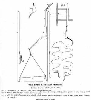
Cod fishing with hand-lines (hand-lining) from the deck of a schooner was the predominant method used on offshore fishing grounds prior to the Civil War. Offshore grounds included the Grand Banks of Newfoundland, the banks off Nova Scotia, numerous small grounds in the Gulf of Maine, and Georges Bank.
Hand-lining from dories and wherries was the inshore version of this fishery, the boats being hauled ashore at the end of a day's work.Their fishing grounds ranged from the shoreline to Ipswich Bay, and a multitude of small grounds a mile or two offshore. Colonial fishermen found the inshore grounds off Cape Ann—particularly Ipswich Bay—extremely rich, so much so that these grounds were the prime sources of market fish in that period.
Early the nineteenth century, hand-lining gear had become surprisingly complex, consisting of two hooks with leaders (gangings), swivels, a bridle and spreader, and a 20-pound sinker and staff. This rig was attached to a hand-line which could be as long as 900 feet, depending on the depth and type of bottom being fished. Gear of this size and complexity was coiled and stowed in a tub, instead of being wound on a wood frame.
Inshore fishing gear was much simpler: a line on a wooden winder, a hook at the end, and a sinker hitched to the line at the desired distance from the hook.
– Erik Ronnberg
Steel engraving after drawing in G. Brown Goode, The Fisheries and Fishery Industries of the United States (Washington, DC: Government Printing Office)
8 1/2 x 11 in. (page size)
Cape Ann Museum Library & Archive, Gloucester, Mass.
See pl. 31.
Shows the two basic types of hand-line gear in use in mid-ninteenth century. At left is the Georges gear, developed for fishing on Georges Bank. At right is shoal water gear, as commonly used in the inshore fisheries using dories and other small craft. The spreader, or "sling-ding" was used on this type of gear with the advent of dory hand-lining on offshore grounds.
Also filed under: Hand-lining »
Steel engraving after drawing in G. Brown Goode, The Fisheries and Fishery Industries of the United States (Washington, DC: Government Printing Office, 1883)
8 1/2 x 11 in. (page size)
Cape Ann Museum Library & Archive, Gloucester, Mass.
See pl. 32.
Also filed under: Georges Bank, Mass. » // Hand-lining »
Stereograph card Cape Ann Museum Library & Archive
Also filed under: Drying Fish » // Flake Yard » // Historic Photographs »
Newsprint
Cape Ann Advertiser
Collection of Fred and Stephanie Buck
"VISIT TO LANE'S STUDIO.
We called at the studio of this artist a few days ago, and found several new paintings had been added to his collection since our last visit. The first that arrested our attention was a view of Good Harbor Beach. . . .
A scene outside Eastern Point, during a fresh sou'wester, is full of life, and faithfully portrayed on the canvass. . . .
A fancy sketch, representing a storm scene, is also on exhibition. . . .
The Artist has now on his easel a large picture 36x60, just commenced, which we should judge would be his master-piece. It will be on exhibition when finished, and we forbear a description of it at this time. Mr. Lane, as a marine painter, ranks first in the country, and we are pleased to chronicle his success in producing such life-like pictures."
Also filed under: Fishing » // Newspaper / Journal Articles » // Rockport, Mass. - Thacher Island Twin Lighthouses » // Studio Descriptions » // Thacher Island »
In G. Brown Goode, The Fisheries and Fishery Industries of the United States (Washington, DC: Government Printing Office)
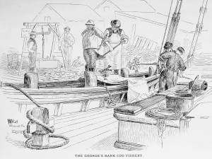
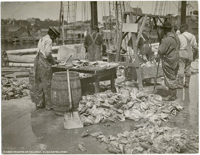
A vessel having returned from the fishing grounds with a fare of split salted cod, is discharging it at a fish pier for re-salting and drying. The fish are tossed from deck to wharf with sharp two-pronged gaffs, and from there to a large scale for weighing. From there, they will be taken to another part of the wharf for washing and re-salting.
– Erik Ronnberg
Also filed under: Drying Fish » // Fishing » // Georges Bank, Mass. »
T. Moore's Lithography, Boston
12 1/2 x 9 1/2 in.
20 x 16 3/4 in (Framed)
Cape Ann Museum, Museum Purchase (2014.089.2)
Also filed under: Johnston, David Claypoole » // Moore's, T. - Lith. - Boston » // Sheet Music by other artists »
New York Public Library
Also filed under: Drying Fish »
Gravure plate printing on pulp paper in G. Brown Goode The Fisheries and Fishery Industries of the United States (Washington, DC: Government Printing Office)
7 1/2 x 5 7/8 in.
Cape Ann Museum Library & Archives, Gloucester, Mass.
See pl. 30.
Derived with modifications from Lane's painting, /entry:9/, the image depicts fishing in heavy weather on Georges Bank. While Lane's version was intended to depict this fishery in the 1840s, Collins' version shows a dory on the stern davits instead of a yawl boat—a practice that became common after the Civil War.
– Erik Ronnberg
Also filed under: Georges Bank, Mass. » // Goode, The Fisheries and Fishing Industries of the United States »
In G. Brown Goode The Fisheries and Fishery Industries of the United States (Washington, DC: Government Printing Office)
See pl. 35.
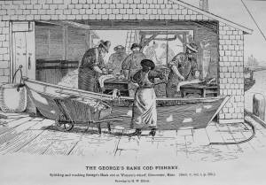
After landing and weighing, the cod are split and washed, a dory filled with water serving as the wash tub. Once thoroughly rinsed of the coarse first salting, the split cod are piled in the wharf shed where they will be re-salted, usually with a finer grade of salt, and stored in bins or large casks until ready for drying on the fish flakes.
– Erik Ronnberg
Also filed under: Drying Fish »
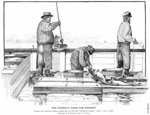
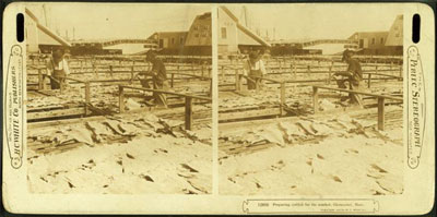
The processing of dried salt cod (the most common form of salt fish) began after the hooked cod came on board and was put in a holding pen on deck until there was a large deck load or the day's fishing was done. At that time, the fish would be split, gutted (the livers were saved, the head removed, and the tongues and cheeks cut out). The split fish were placed in pens in the hold, carefully salted as they were stacked in layers. This initial salting kept them in good condition until they were landed at the fish pier.
After landing, each fish was carefully washed in a dory filled with sea water, removing much of the initial salting. They were then given a second salting, using a finer grade with fewer impurities. Then they were loaded onto a barrow or cart, and wheeled to the flake yard, where they were spread out on wooden racks, called "fish flakes," to dry. Drying time could take days, depending on weather and temperature. Warm, sunny weather could speed up the drying time, but also "burn" the fish, spoiling its texture and flavor. To prevent this, canvas awnings were stretched over wooden frames built onto the flakes.
Rain was also harmful to the fish, which were gathered in compact piles on the flakes and covered with up-turned wooden boxes until dry weather returned. Once dried, the fish were returned to the fish house and stored in a dry room, awaiting skinning, trimming, and packaging for the domestic market.
– Erik Ronnberg
c.1900.
Also filed under: Flake Yard »
Stereograph card Cape Ann Museum Library & Archive
Also filed under: Cod / Cod Fishing » // Flake Yard » // Historic Photographs »
Wood drying racks, metal split salt fish. Scale: ½" = 1' (1:24)
Original diorama components made, 1892; replacements made 1993.
Cape Ann Museum, from Gloucester Chamber of Commerce, 1925 (2014.071)
Fish flakes are wood drying racks for salt codfish, and have been used for this purpose in America since colonial times.
Also filed under: Flake Yard »
In G. Brown Goode, The Fisheries and Fishery Industries of the United States (Washington, DC: Government Printing Office)
A vessel having returned from the fishing grounds with a fare of split salted cod, is discharging it at a fish pier for re-salting and drying. The fish are tossed from deck to wharf with sharp two-pronged gaffs, and from there to a large scale for weighing. From there, they will be taken to another part of the wharf for washing and re-salting.
– Erik Ronnberg
Also filed under: Cod / Cod Fishing » // Fishing » // Georges Bank, Mass. »
New York Public Library
Also filed under: Cod / Cod Fishing »
In G. Brown Goode The Fisheries and Fishery Industries of the United States (Washington, DC: Government Printing Office)
See pl. 35.
After landing and weighing, the cod are split and washed, a dory filled with water serving as the wash tub. Once thoroughly rinsed of the coarse first salting, the split cod are piled in the wharf shed where they will be re-salted, usually with a finer grade of salt, and stored in bins or large casks until ready for drying on the fish flakes.
– Erik Ronnberg
Also filed under: Cod / Cod Fishing »
Also filed under: Fishing »

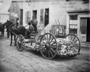
5' 11" l. x 28" h. x 23" w. Wheel 20" d.
19th–early 20th century
Cape Ann Museum. Gift of the Gloucester Fishermen's Museum (2542)
Used to move salt fish in a flake yard. Barrows of this type were commonly used to carry a wide variety of materials around the waterfront.
Also filed under: Objects »
Fishing and commerce came late to Gloucester Harbor, other harbors on Cape Ann having been developed sooner for these purposes. The rich and varied stocks of fish in Ipswich Bay and off Sandy Bay made the coves and harbors of Cape Ann's northern and eastern shores more convenient for shore fishermen in colonial times. The early successful permanent settlements on Cape Ann were in Annisquam Harbor and along the Annisquam River, leading to the establishment of Cape Ann's First Parish in that area. (1)
Shipbuilding in Gloucester Harbor began in the mid-seventeenth century, and by its end had produced a sizeable fleet of vessels which were active in the Grand Banks fishery. By the early 18th century, Gloucester Harbor was a busy fishing port becoming the economic center of Cape Ann—a reality finally recognized in 1740, when the First Parish built a new meeting house at the harbor, officially confirming its leading role. (2)
Gloucester's fishing enterprise was fueled by a demand for fish in Europe and their colonies in the West Indies. Vessels shipping fish to Europe returned with domestic wares and materials unavailable locally. Shipments of dried fish of lower grades went to plantations in the West Indies to feed their slaves; return cargos were usually sugar, molasses, and fine hardwoods to be used for cabinetry. By the 19th century, this trade had extended to Surinam, where fine Dutch domestic wares were added to the imports list. The Surinam Trade became Gloucester's dominant maritime activity in the first half of the nineteenth century. (3)
Success in the Surinam Trade led to using ever larger vessels to carry the goods - a problem for a shallow harbor with no dredging facilities. This forced Gloucester shipowners to move their port facilities and offices to Boston; after 1850, very few Surinam goods were landed at Gloucester. This opened Harbor Cove (Gloucester's prime port facility) to the fishing industry, just as momentous changes were to take place in fishing technology. (4)
Improvements to fishing methods and gear, namely dory trawling and mackerel seining, dramatically improved catches of cod and mackerel—at a cost. The gear was expensive. Gloucester was in a unique position to take advantage of this gear, thanks to banks and insurance firms with strong interests in the industry, local manufacturers of the new fishing gear, and a steady influx of young men eager for the work. The post-Civil War years saw a rapid rebuilding of Gloucester's fishing industry which could not be matched by rival New England fishing ports. (5)
– Erik Ronnberg
References:
1. Mary Ray, and Sarah V. Dunlap, Gloucester, Massachusetts Historical Time-line, 1000–1999 (Gloucester, MA: Archives, 2002), 10–16.
2. Ibid., 12, 17, 20, 24–25, 27–28, 30.
3. Alfred Mansfield Brooks, Gloucester recollected: A Familiar History (Gloucester, MA: Peter Smith, 1974), 50–69.
4. Ibid.
5. Wayne M. O'Leary, Maine Sea Fisheries (Boston: Northeastern University Press, 1996), 160–79.
Newspaper
Ad in Gloucester Telegraph
FISHING AND SAILING PARTIES
"Persons desirous of enjoying a SAILING or FISHING EXCURSION, are informed that the subscriber will be in readiness with the Boat EUREKA, to attend to all who may favor him with their patronage. JOHN J. FERSON"
Also filed under: Newspaper / Journal Articles » // Party Boat »
Prior to marine railways, the only way to clean and repair a vessel’s bottom was to bring it as far ashore on a sandy beach as tide would allow, then wait as the tide ebbed, leaving the vessel high and dry. Tidal amplitude (the difference between high tide and low tide) ranged between nine feet and twelve feet on Cape Ann (neap tide and spring tide), allowing reasonable working time for vessels drawing seven to ten feet. This was suitable for most fishing schooners and smaller craft, but larger vessels would need the services of marine railways, graving docks, or “heaving-down” facilities in larger ports. (Ref. 1)
The most desirable graving beaches had clean, firmly-packed sand with rock-free areas large enough to accommodate local vessels. Gloucester’s Harbor Cove had such a beach along its south-west side which was actually the part of Pavilion Beach which faced the cove. Two of Lane’s depictions of Harbor Cove (View of Gloucester Harbor, 1848 (inv. 97) and The Fort and Ten Pound Island, Gloucester, Massachusetts, 1847 (inv. 271)) show this beach in their far right backgrounds, with schooners grounded out and men working on them.
The term “graving” also applied to docks fitted at one end with watertight gates which, when closed, allowed the dock to be pumped dry so a docked vessel could be worked on at all hours. Such facilities are commonly called “dry docks” and were found in Boston, Portsmouth, New York, and other large ports with major merchant or naval facilities. (Ref. 2)
–Erik Ronnberg
References:
1. “A Naval Encyclopaedia” (Philadelphia: L. R. Hamersly & Co., 1884. Reprint: 1971), p. 318.
2. “The Oxford Encyclopedia of Maritime History” (Oxford and New York: Oxford University Press, 2007), Vol. 1, p. 571.
44 x 34 in.
Henry Francis Walling, Map of the Towns of Gloucester and Rockport, Essex Co. Massachusetts. Philadelphia, A. Kollner, 1851
Cape Ann Museum Library & Archive
"Map of the Towns of Gloucester and Rockport, Massachusetts. H.F. Walling, Civil Engineer. John Hanson, Publisher. 1851. Population of Gloucester in 1850 7,805. Population of Rockport in 1850 3,213."
Segment of Harbor Village portion of map showing Collins' and other wharves in the Inner Harbor.
Also filed under: Gloucester Harbor, Inner / Harbor Cove »
Prior to 1840, the lobster fishery had but a minor role in the American fishing industry. The market was limited by the difficulties of transporting live lobsters over long distances, which kept the demand local. As transportation (by rail), improved, the market broadened and demand increased, leading to more fishing and reduction of lobsters, both in size and in numbers.
In Lane's later years, the fishery was growing, but significant decreases of lobsters were not yet considered serious. Decrease in numbers of very large lobsters (weighing ten pounds or more) was noted, but clamors for regulations on sizes and numbers of lobsters caught were not heard until the 1870s.
Lobster traps in the nineteenth century were mostly of the "round top" design—built of wooden laths with funnel-shaped entries of netting at both ends. The tops were hinged "lids" providing access to the catch; stones were fitted as weights to the flat bottom.
The pots could be set individually or in "strings" with marker buoys at both ends of the string. Individual pots were set on rocky bottom where a string of pots could become fouled and lost. Strings of pots were best for a smooth bottom when lobsters were moving inshore in large numbers. When lobsters were scarce on smooth bottoms, individual pots were set, being easier to move to other places.
Once caught, lobsters were kept in floating boxes (called "cars") with open seams and bored holes to allow water to circulate. A lobster car with a "killick" (stone anchor) is depicted by Lane in the foreground of Gloucester Inner Harbor, 1850 (inv. 240).
– Erik Ronnberg
Reference:
G. Brown Goode, "Fisheries and Fishery Industries", Section V, Vol. 2, 658–74.
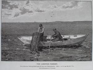
In G. Brown Goode, The Fisheries and Fishery Industries of the United States (Washington, DC: Government Printing Office)
Cape Ann Museum Library & Archive, Gloucester, Mass.
See pl. 247.
This photo was most likely taken in Ipswich Bay on the north shore of Cape Ann (visible in right background). During the warm months, lobsters migrate to the shore where they feed and shed their outgrown shells while hiding among the rocks. Dories are the lobstermen's choice for working traps out in the bay or close to shore in rocky shallows. Pots can be set individually or in strings, the latter on smoother ground where the line is less likely to be fouled.
– Erik Ronnberg
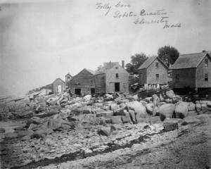
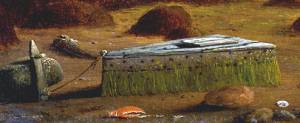
Gloucester Inner Harbor
Oil on canvas
24 x 36 in. (61 x 91.4 cm)
The lobster car was a floating holding tank for lobsters that were kept in the harbor prior to local sale or transportation to fish markets in Boston.
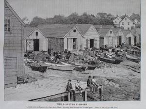
In G. Brown Goode, The Fisheries and Fishery Industries of the United States (Washington, DC: Government Printing Office)
Cape Ann Museum Library & Archive, Gloucester, Mass.
See pl. 249.
Lobster Cove (Lane's Cove) was a thriving port for the Ipswich Bay shore fisheries from colonial times through the 19th century. Even as late as the mid-20th century, the waterfront was lined with sheds for fishing gear - now all gone. In addition to lobstering, gill-netting, trap fishing, hand-lining, and seining (small-scale) were carried on at various times in pursuit of numerous fish and shellfish types.
– Erik Ronnberg
Also filed under: Folly Cove »
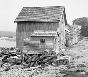
Glass plate negative
4 x 5 in.
Cape Ann Museum Library & Archive
#10205/418
Also filed under: Folly Cove »

c. 1900 Glass plate negative Collection of Erik Ronnberg
Also filed under: Schooner (Coasting / Lumber / Topsail / Packet / Marsh Hay) »
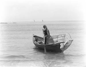
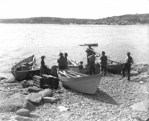
The timber trade played an important role in New England’s economy from Colonial days through the mid-19th century, supplying the vast quantities of lumber which a rapidly growing nation demanded. While Cape Ann’s woodlands were depleted early on, timber continued to be harvested from northern New England and the Maritime Provinces right up to the Civil War.
With a deep and safe harbor, Gloucester often served as a layover spot where vessels bound from Maine to Boston, New York or Baltimore and heavily laden with lumber could ride out bad weather. Because of this, Fitz Henry Lane’s paintings of Gloucester Harbor often show a schooner or a brig, loads of lumber clearly visible on their decks, sheltering along the Western Shore.
References:
Honey, Mark E., "King Pine, Queen Spruce, Jack Tar," An Intimate History of Lumbering on the Union River, Volumes 1-5. This source, in its entirety, lays down the foundation of Downeast Maine's unique culture which was built upon pine lumber and timber, the cod fisheries, coasting, shipbuilding, and the interrelationships of family and community.

1852 Photograph
Also filed under: Schooner (Coasting / Lumber / Topsail / Packet / Marsh Hay) »
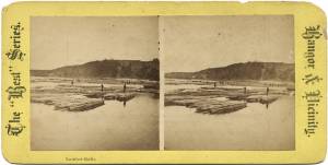
Advertisement for The Bangor News Company, est. January 31, 1881 Castine Historical Society Collections (2008.02)
Also filed under: Historic Photographs »
"The Maine Register for the Year 1855, embracing State and County Officers, and an abstract of the law and resolves; together with a complete business directory of the state, and a variety of useful information."
Details about Maine's lumber trade in 1855, see pp. 250–52
Also filed under: Castine » // Schooner (Coasting / Lumber / Topsail / Packet / Marsh Hay) »
The construction of the Gloucester branch of the Eastern Railroad from Salem in 1848 transformed Cape Ann from a sleepy rural area to a bustling metropolis, with summer visitors from Boston and New York arriving daily. The development of the tourist industry was part of a more general growth of tourism up and down the east coast of the United States. Seacoast and mountain areas were served first by stage coaches and then by railroads bringing urban visitors during the summers. Cape Ann was also a day trip for summer residents of places like Beverly and Manchester.
The railroad journey from Boston was not a difficult one. An advertisement listed in the Boston Directory of 1848 reported that there were eleven trains a day for Portsmouth and Salem. It also noted the: "Advantages of a Residence on this Route. No Railroad affords access to so many, so varied, and so splendid sea-side locations, or passes through so many pleasant cities, towns, and vlllages. Its Depots are within a mile or two of the celebrated beaches of Chelsea, Nahant, Swampscot, and Marblehead. A Branch [railroad] skirts the shores of Massachusetts Bay, in the towns of Beverly, Manchester, and Gloucester, opening most magnificent views of the ocean, leading to most retired spots for sea-bathing, and to the most delightful walks and drives in the native forests, that can be found in New England. This shore is rapidly filling up with marine villas and cottages."
By the 1850s Gloucester had three full-size hotels, the Pavilion, the Union House, and the Gloucester House, as well as a number of summer residents, such as Charles Hovey.
Newspaper
"Among the many visitors of the Cape at this delightful season is Champney, the artist, who has been sketching among our quiet coves and breezy headlands."
Also filed under: Champney, Benjamin » // Newspaper / Journal Articles »