An online project under the direction of the CAPE ANN MUSEUM
Historical Materials
Historical Materials » Maritime & Other Industries & Facilities » Graving Beach
Graving Beach
View related Fitz Henry Lane catalogue entries (3) »
Prior to marine railways, the only way to clean and repair a vessel’s bottom was to bring it as far ashore on a sandy beach as tide would allow, then wait as the tide ebbed, leaving the vessel high and dry. Tidal amplitude (the difference between high tide and low tide) ranged between nine feet and twelve feet on Cape Ann (neap tide and spring tide), allowing reasonable working time for vessels drawing seven to ten feet. This was suitable for most fishing schooners and smaller craft, but larger vessels would need the services of marine railways, graving docks, or “heaving-down” facilities in larger ports. (Ref. 1)
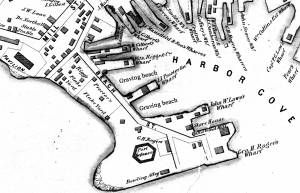
The most desirable graving beaches had clean, firmly-packed sand with rock-free areas large enough to accommodate local vessels. Gloucester’s Harbor Cove had such a beach along its south-west side which was actually the part of Pavilion Beach which faced the cove. Two of Lane’s depictions of Harbor Cove (View of Gloucester Harbor, 1848 (inv. 97) and The Fort and Ten Pound Island, Gloucester, Massachusetts, 1847 (inv. 271)) show this beach in their far right backgrounds, with schooners grounded out and men working on them.
The term “graving” also applied to docks fitted at one end with watertight gates which, when closed, allowed the dock to be pumped dry so a docked vessel could be worked on at all hours. Such facilities are commonly called “dry docks” and were found in Boston, Portsmouth, New York, and other large ports with major merchant or naval facilities. (Ref. 2)
–Erik Ronnberg
References:
1. “A Naval Encyclopaedia” (Philadelphia: L. R. Hamersly & Co., 1884. Reprint: 1971), p. 318.
2. “The Oxford Encyclopedia of Maritime History” (Oxford and New York: Oxford University Press, 2007), Vol. 1, p. 571.
44 x 34 in.
Henry Francis Walling, Map of the Towns of Gloucester and Rockport, Essex Co. Massachusetts. Philadelphia, A. Kollner, 1851
Cape Ann Museum Library & Archive
"Map of the Towns of Gloucester and Rockport, Massachusetts. H.F. Walling, Civil Engineer. John Hanson, Publisher. 1851. Population of Gloucester in 1850 7,805. Population of Rockport in 1850 3,213."
Segment of Harbor Village portion of map showing Collins' and other wharves in the Inner Harbor.
Also filed under: Gloucester Harbor, Inner / Harbor Cove »