An online project under the direction of the CAPE ANN MUSEUM
Catalogue Entry
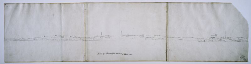
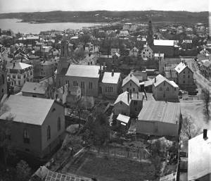
While its detail has been lightly drawn and highly abbreviated, this drawing offers a panoramic view of the northeast end of Gloucester Harbor from the Cut to Head of the Harbor—the latter partially obscured by Ten Pound Island and Rocky Neck. The shore line and direction of view are similar to Off Gloucester Harbor, Massachusetts, c.1855 (inv. 559) which takes in much of the same skyline, but from a slightly different viewing point. Both images are part of a group of Lane’s work which look back toward the town from viewing points around the Outer Harbor, especially its western shore (Gloucester Harbor, 1852 (inv. 38), Gloucester from Brookbank, 1848 (inv. 42), Gloucester Harbor, 1856 (inv. 75), Early Morning, Pavilion Beach, Gloucester, c.1850–55 (inv. 78), and View of Gloucester from "Brookbank," the Sawyer Homestead, c.1856 (inv. 95)). This drawing is one of his few such depictions as seen from the water.
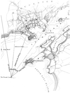
In Off Gloucester Harbor, Massachusetts, c.1855 (inv. 559), the angle of view was found to be 60 degrees from a viewing point close to Ten Pound Island and even closer to Ten Pound Island Ledge. Using the same 60 degree angle (divided into four 15 degree segments), and moving the viewing point west, slightly beyond Ten Pound Island Ledge, it was found to cover the breadth of the drawing with the identified objects close to—often exactly on—their positions in the U.S. Coast Survey chart used in this exercise. These objects are identified by number on a high-contrast image of the drawing and on the viewpoint map derived from the survey chart below:
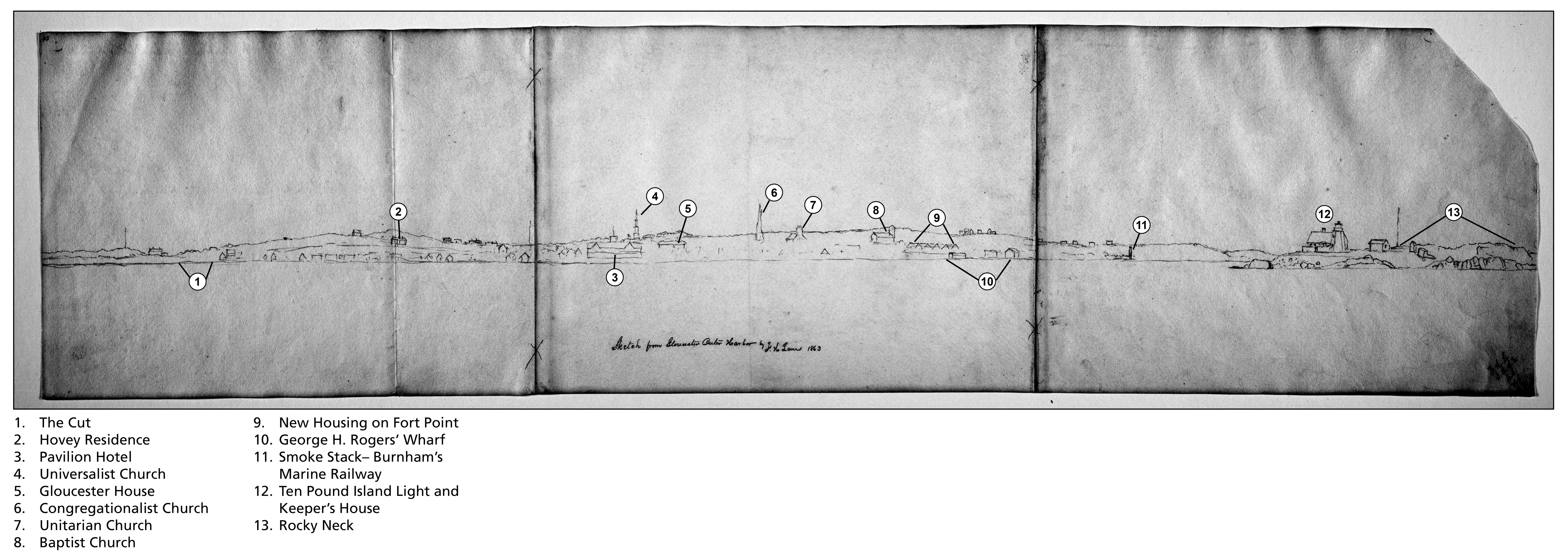
The Cut (1), where the Annisquam River meets Gloucester Harbor was formerly an isthmus which was periodically opened and bridged, refilled and reopened, until finally made a permanent bridged waterway in 1868.
The summer residence of Charles Hovey (2) was built 1847 on Babson’s Hill, overlooking Pavilion Beach. Hovey was a wealthy Boston merchant, an early summer resident, and an early user of the railroad connection to Gloucester to commute to his office in Boston.
The Pavilion Hotel (3) was built in 1849 by Sidney Mason, a Gloucester native and New York merchant, to provide pleasant lodging for Cape Ann’s summer visitors.
The Independent Christian Church, Universalist (4), at the corner of Middle and Church Streets, was built in 1805 and stands today. Its steeple – long the tallest in Gloucester – made it a useful guide to vessels entering the harbor prior to the building of lighthouses.
The Gloucester House (5), a brick building at the corner of Washington and Front (now Main) Streets, was one of the earliest hotels established for year-round operation, catering to visitors on business.
Trinity Congregational Church (6), rebuilt after a fire in 1854, had for eleven years the tallest steeple in Gloucester, although not with a lantern at its peak. The steeple was replaced by an elaborate belfry.
The Unitarian (formerly First Parish) Church (7) was built in 1828 and given a bell tower with four short spires on its corners.
The Second Baptist Church (8) was built in 1851 in response to a rapidly growing congregation. Built of wood, it was painted a reddish brown to resemble a brick structure.
Residential buildings on Fort Point (9) block a southern view of the remains of Fort Defiance in what is so far Lane’s earliest depiction of them. The development of Fort Point began in the late 1840s when George H. Rogers started building a large wharf on its east side, followed in the 1850s by two finger piers along the south side. Surviving floor plans of the five houses depicted by Lane suggest that they were double-occupancy tenements.
George H. Rogers’ wharf complex (10) was begun in 1848 with the construction of a stone bulkhead pier on Fort Point’s East side. Intended for serving his interests in the Surinam Trade, it was soon used mainly for the fisheries.
A smoke stack rises over the site of Burnham Brothers’ marine railway (11), an area formerly used for shipbuilding until c.1849–50, when a marine railway was built and the firm was devoted entirely to vessel maintenance.
Ten Pound Island Light House (12) was built in 1821 – the first light house to mark the entrance to Gloucester Harbor.
Rising beyond and above Ten Pound Island, Rocky Neck (13) is more an island connected by a narrow causeway. Long used as pasture land, it was only beginning to become a business and residential area in the 1860s.
– Erik Ronnberg
References:
1. Joseph E. Garland, “The Gloucester Guide” (Rockport, MA: Protean Press, 1990).
2. Mary Ray (Compiler) and Sarah Dunlap (Editor), “Gloucester Massachusetts Historical Time Line” (Gloucester, MA: Gloucester Archives Committee, 2002).
The initials in the lower right corner are thought to indicate Lane, his friend Joseph Stevens, Jr. and his wife Caroline, and their daughter Helen, probably his companions on this outing. The identity of G.F. has not been determined.

- Subject Types
: - Cape Ann Locales
: - Building Types
:
Historical Materials
Although in his 1852 Gloucester Harbor, Lane painted the Second Baptist Church to look like Italian brick, this building was in fact clad in New England clapboard, of an unknown but perhaps reddish color. It was the second Baptist church built in Gloucester, the first being just up Pleasant Street and visible in the same painting as the white steeple to the left. The second Baptist Church was designed by Gridley J.F. Bryant of Boston (the same architect who twenty years later would design Gloucester's City Hall) and was dedicated the year before, in March 1851. The minister at the time of the 1852 painting was Miles Sanford.
The church replaced a tavern on land directly across the street from Lane's childhood home. Lane never painted his old house, sold out of the family in 1839, but its location is often near the center of canvases of the harbor. In Gloucester Harbor, 1852 (inv. 38) painting at CAM, it was in the cluster of wooden houses partially covering the wall of the second Baptist church, to the right of the ship's mast. It was here that the young Nathaniel Rogers Lane played, ate the legendary and hypothetical "apple of Peru" to cause his lameness, learned the shoemaker's trade, and drew his early sketches of boats and sails. The site of the Lane house is now occupied by the old Gloucester Cooperative Bank building at 85 Middle Street.
This Baptist Church burned in December 1869, and was replaced in 1871 by the third Baptist church to stand on Pleasant Street, which in turn was torn down in 1966 to create a parking lot. But the large granite block used as its front step now forms the bottom of the pathway from the parking lot on Rogers Street up to the stone Fitz Henry Lane house.
Current address: Parking lot on Pleasant Street between Middle and Warren Streets, opposite the Cape Ann Museum.
– Sarah Dunlap (August, 2013)
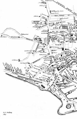
44 x 34 in.
Henry Francis Walling, Map of the Towns of Gloucester and Rockport, Essex Co. Massachusetts. Philadelphia, A. Kollner, 1851
Cape Ann Museum Library & Archive
"Map of the Towns of Gloucester and Rockport, Massachusetts. H.F. Walling, Civil Engineer. John Hanson, Publisher. 1851. Population of Gloucester in 1850 7,805. Population of Rockport in 1850 3,213."
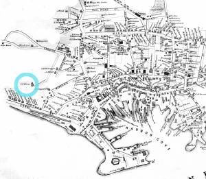
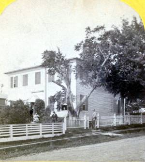
This was Charles F. Hovey's new house when Lane painted Gloucester Harbor from Rocky Neck, 1844 (inv. 14), the hilltop house on the horizon at the far left of the canvas, above the Fort. It is identified as the C.F. Hovey house on the 1851 Walling map and stood high above the outer Harbor, overlooking Gloucester's waterfront. The house that Charles Hovey built has been greatly altered by several owners over the years, but still commands an impressive view of the surrounding sea and land.
The brothers Charles Fox Hovey and George Otis Hovey, sons of Darius and Sarah, were born in Brookfield, Massachusetts. They first appeared in the Gloucester Assessor's Valuations in 1846, when Charles had a house, barn and land worth the substantial sum of $3,000, and George had land and an unfinished house worth $1,000, the beginnings of a vast estate on Dolliver’s Neck, Fresh Water Cove. The brothers enrolled in the Gloucester militia in 1847.
By 1851, both Charles and George lived in Boston, although they continued to own and pay taxes on their Gloucester houses. Charles was an abolitionist of note and a supporter of the women's rights convention. Charles F. Hovey died in Boston on April 28, 1859 of rheumatic gout. The posthumous $50,000 Hovey Fund was managed and allocated by the abolitionist and reformer, Wendell Phillips. George was a merchant and died in Gloucester on July 18, 1877.
Current address: 6 Hovey Street.
– Sarah Dunlap (January, 2014)
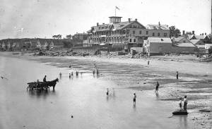
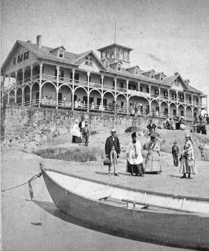
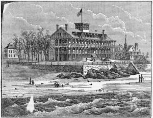
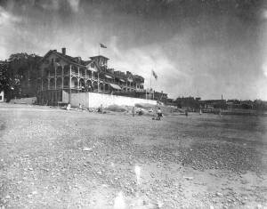
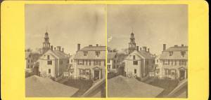
The Pavilion, built in 1849 for Sidney Mason, was Gloucester's first summer resort hotel. Mason was a patron of Lane, and he commissioned him to paint three views of scenes of his mercantile successes: New York Harbor, San Juan [Saint John] Harbor, and Gloucester Harbor, 1852 (inv. 38), in which the hotel, with all its porches, towers and tracery, is a prominent feature. Mason himself helped the architect S. Charles Bugbee design the building, that was then constructed by White and Winchester. A grist windmill, originally owned by Ignatius Webber and then by Sidney Mason's father, John Mason, had stood on the hill since 1814, but, in preparation for the Pavilion Hotel, was moved to the inner-harbor side of the old Fort and eventually burned in 1877. Both the windmill and the Fort can be seen in several Lane harbor paintings and drawings.
Sidney Mason lived in New York City at this time but was closely connected to his home town of Gloucester and owned another, traveler's hotel, the Gloucester House. But the Pavilion brought in an entirely new and different type of visitor to the fishing and trading town of Gloucester. The railroad from Boston had reached Salem in 1839 and Gloucester in November 1847. This not only led to Lane's return to Gloucester after his fifteen year residence in Boston, it also facilitated an influx of summer people. Before this time, a combination of stagecoaches, ferries, steamers and trains was needed to make the trip. Now, the wealthy from New York and Philadelphia could travel easily to Gloucester, as well as to other North Shore communities.
The hotel was not isolated from the business of the town. Next door to the west was one of the several long ropewalks in town. It was built by Ignatius Webber in 1803 and produced many of the miles of hemp rope and twine needed in the maritime trading and fishing trades. To the east, along the beach, were flake yards, where acres of split cod and other fish were laid out to dry in the sun. Lane did not include these in his painting. Nor is there any sign of tension between the tourist hotel and the local inhabitants and industries.
The Pavilion Hotel offered spectacular views and walks, both coastal and inland, and bathing was available all along the public beach that stretched to the Fort. The hotel itself was advertised as elegant, with luxurious sitting rooms, gas lighting and modern conveniences. Its first years were not entirely successful under the management of Dr. H.T. Haughey, once manager of Delaware's Brandywine Springs. But in 1852, Col. Abijah Peabody, manager of Mason's other hotel, the Gloucester House, took over the Pavilion and it flourished.
The Pavilion Hotel grounds were used during the Civil War as a recruiting office. It became the Surfside Hotel, and burned on Saturday, October 17, 1914. It was soon replaced by the Tavern, and that building still exists although no longer as a hotel and without the elegance and architectural flare of the original Pavilion.
Current address: 28–30 Western Avenue, The Tavern.
– Sarah Dunlap (September, 2013)
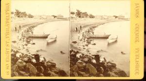
Stereograph card
Cape Ann Museum Library & Archive
Pavilion Hotel and the beach looking west from the Fort, Beach Court and Western Avenue.
Also filed under: Pavilion (Publick) Beach »
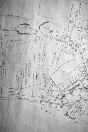
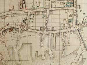
1834–35 Lithograph 24 x 38 in. Gloucester City Archives
"Drawn on a scale of one hundred feet to an inch. By John Mason 1834–45 from Actual Survey showing every Lott and building then standing on them giving the actual size of the buildings and width of the streets from the Canal to the head of the Harbour & part of Eastern point as farr as Smith's Cove and the Shore of the same with all the wharfs then in use. Gloucester Harbor 1834–1835."
This section of the map shows the location of the Pavilion Hotel and ropewalk along the beach.
Also filed under: Maps » // Mason, John » // Pavilion (Publick) Beach » // Ropewalk » // Windmill »

1851 44 x 34 in. Henry Francis Walling, Map of the Towns of Gloucester and Rockport, Essex Co. Massachusetts. Philadelphia, A. Kollner, 1851 Cape Ann Museum Library & Archive
"Map of the Towns of Gloucester and Rockport, Massachusetts. H.F. Walling, Civil Engineer. John Hanson, Printer. 1851. Population of Gloucester in 1850 7,805. Population of Rockport in 1850 3,213."
Also filed under: Baptist Church (Old, First, 1830) (Pleasant Street) » // Burnham Brothers Marine Railway » // Duncan's Point » // Five Pound Island » // Flake Yard » // Gloucester Harbor, Inner / Harbor Cove » // Harbor Methodist Church (Prospect Street) » // Low (Frederick G.) wharves » // Procter Brothers » // Ropewalk » // Vincent's Cove » // Western Shore »
Newspaper
Gloucester Telegraph p. 2 col. 2
Boston Public Library
Accession # G587
"Charlotte Cushman leaves for Europe today in steamship Asia, from New York,– She takes with her two of Lane's finest marine paintings, which she purchased on Monday."
Also filed under: Cushman, Charlotte » // Newspaper / Journal Articles »
1854 Newspaper "Letters on Art. - No. IV"
"In that space [four years] the town has grown greatly . . . a great ugly, yellow "Pavilion" suns itself on the rocks . . . I said there are only two stone buildings in this town of Gloucester: one is "the Bank," the other belongs to Mr. F. H. Lane, whose name ought to be known from Maine to Georgia as the best marine painter in the country.
If Mr. Lane is not as well known as he ought to be, he has at least no reason to complain of neglect or want of appreciation. He has been painting only fifteen years, and his pictures are in great demand; hitherto chiefly among sea-faring men, but now winning way in other circles. In former times I used to be often in Mr. Lane's painting-room, and it was with real pleasure that I found my way to his new house, built from his own design, of native granite, as I mentioned, handsome, peculiar, stable, and commanding a wide sweep of land and ocean from its ample windows. The house is the best that has been built in Gloucester for fifty years. . .
Mr. Lane has put few pictures in his studio at present; for he is very industrious, and sends his canvases off as fast as they are filled. If you were to meet him in the street, you would hardly take him for an artist. A man apparently of forty years, walking with difficulty, supported by crutches, hard-handed, browned by the sun and exposure, with a nose indicating less the artist sensibility than the artist resolution . . .
His early pictures had something in them too hard and practical to permit enthusiastic admiration; the water was salt, the ships sailed, the waves moved, but it was the sea before the Spirit of God moved upon the face of the deep.
His pictures early delighted sailors by their perfect truth. Lane knows the name and place of every rope on a vessel; he knows the construction, the anatomy, the expression – and to a seaman every thing that sails has expression and individuality . . . [Lane] has earned his money thus far mostly by painting "portraits" of vessels for sailors and ship-owners. It is owing to this necessity, perhaps, that he has fallen into the fault of too great literalness of treatment, which I have mentioned as characterizing some of his earlier works; but with the rapid advance he has made in the past four years, there is no longer any fear that he is incapable of treating a subject with genuine imagination . . .
He has indulged in no tricks and no vagaries; he has slighted nothing, despised nothing. If I appear to think less of his early pictures than they deserve, it is not because they are carefully even painfully studied, and because no detail has escaped his eye or brush; it is not that he has too much conscience; but simply because I missed in them the creative imagination of the artist. But it may well be a question whether at this day, when slight and untruthful work prevails, when artists will not paint with conscience, and the public does not strenuously demand it, conscience and love are not higher needs than imagination, and whether Mr. Lane's early pictures, the landmarks on his toilsome, earnest journey to his present place, have not a great value of their own. There is not one of them that I have seen, without some valuable passage, showing acute observation and careful, studious execution.
A sea-piece, "Off the coast of Maine, with Desert-Island in the distance," is the finest picture that Mr. Lane has yet painted. The time is sunset after a storm. The dun and purple clouds roll away to the south-west, the sun sinks in a glory of yellow light, flooding the sea with transparent splendor. Far away in the offing, hiding the sun, sails a brig fully rigged . . . I urged Mr. Lane to send this picture to New-York for exhibition . . ."
Also filed under: Newspaper / Journal Articles » // Residences »
Newsprint
Gloucester Telegraph
Cape Ann Museum Library & Archive
At a Sanitary Fair held at the Pavilion "obtained through the favor and generosity of the owner, Mr. SIDNEY MASON, of New York, and to whom many thanks are due." "... hangs a fine picture, the generous gift of our own Artist, Mr. Lane. The Subject is "Coffin's Beach," as seen from the "Loaf." This is the most costly article on sale in the rooms, and is valued at $100. It will be disposed of by tickets $1 each."
Two paintings by Lane, Little Good Harbor Beach and View from the Loaf were on sale at the Fair.
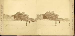
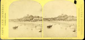
c.1870s Stereograph card Cape Ann Museum Library & Archive
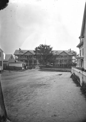
Stereo view of the Pavilion from the southern or sea side.
Also filed under: Historic Photographs » // Pavilion (Publick) Beach »
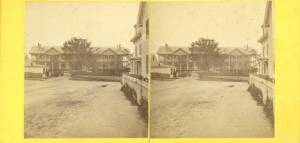
Stereograph card Hervey Friend, Gloucester, Mass., Publisher Cape Ann Museum Library & Archive
Stereo view of the Pavilion Hotel from the street side.
Also filed under: Historic Photographs »
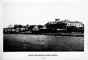
c.1890 Stereograph card Cape Ann Museum Library & Archive
"In the foreground is a clear sheet of water which washes upon the beach beyond. The Pavilion is quite prominent, while upon the rising background can be seen the steeples of the several churchs, the tower of the first Town House, and the Collins School House."
Also filed under: Gloucester – City Views » // Historic Photographs » // Stage Rocks / Stage Fort / Stage Head »
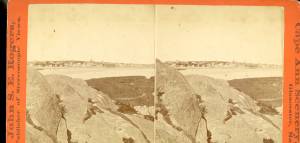
c.1880 Stereograph card Cape Ann Museum Library & Archive
"Bond's Hill is a high eminence on the west side of Gloucester Harbor. The foreground is very rocky and shows a portion of the old road to West Gloucester and Essex, used before the road was built across the marsh, which is to be seen in the center of the picture. Beyond the marsh road is the canal with its dyke. Then the ground rises and dwelling houses appear, till Lookout Hill (or Mount Vernon Street.) can be seen on the left of the background. On the right of the picture is the 'Cut' road, the only carriage entrance into the main part of the town. Beyond it is to be seen 'Crescent Beach,' with the Pavilion and 'old Fort' and a portion of East Gloucester in the background. In the centre of the picture can be seen the unfinished tower of the Town House, and in the distance is the open sea, with Thatcher's Island and its lighthouses just discernible."
Also filed under: Gloucester – City Views » // Historic Photographs »
c.1870s Stereograph card Cape Ann Museum Library & Archive
Also filed under: Historic Photographs » // Pavilion (Publick) Beach »
c.1870s Stereograph card Cape Ann Museum Library & Archive
Also filed under: Historic Photographs » // Pavilion (Publick) Beach »
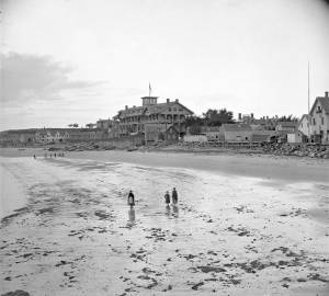
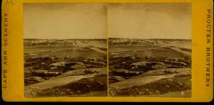
c.1870 Cape Ann Museum Library & Archive
Taken from Fort Point looking west. Ropewalk just to west of hotel.
Also filed under: Historic Photographs » // Pavilion (Publick) Beach » // Ropewalk »
c.1900.
Also filed under: Pavilion (Publick) Beach »
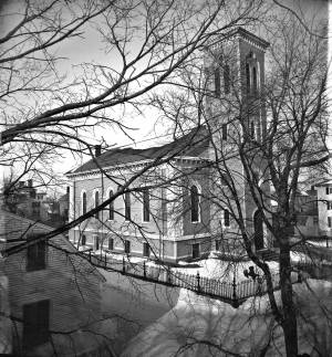
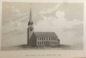
The First Parish (Unitarian) meeting house, located on Middle Street, was a wooden framed, clapboard-sheathed structure with a distinctive four-pointed neo-Gothic inspired tower. It was built in 1828, as the First Parish Church, replacing an earlier structure built on the site in 1738, when the "first" parish moved to the Harbor from its original location on the Annisquam River near where the Rte. 128 Grant Circle now is laid out. The parish system dated from the Massachusetts Bay Colony times, when both religious and civic business was conducted in the parish meetinghouses. This 1828 building was a descendant of that system. It became the Unitarian Church gradually in the 1830s, when more traditional members separated, formed their own society and built the Congregational/Trinitarian Church two doors to the west on Middle Street. The Universalists, Methodists, and Baptists had already seceded and formed their own congregations, and the parish system was at an end.
The Unitarian William Mountford, newly arrived from England, preached in this church from 1850 to 1853. In 1852, a new organ was dedicated on July 4, and Rev. Mountford was installed formally on August 3. (1) It is not known if Lane himself was a member of this or any church, but he shared several traits with Mountford: they both walked with a limp, and they were both interested in Spiritualism. Mountford moved to Boston in 1853 to pursue Transcendentalism and Spiritualism, and seldom returned to Gloucester. But he did come back in August, 1865, to officiate at Fitz Henry Lane's funeral, although Rev. Robert P. Rogers was minister at the time. It was from this church that Lane's body made its final journey to the Oak Grove Cemetery, where he was buried in the family plot of Joseph L. Stevens, Jr.
This building remained the Unitarian Church through the 1940s; however, the congregation had dwindled significantly and was no longer able to maintain the structure. The Gothic steeple was removed during this time. By 1950, the few remaining congregants were meeting with the Universalists further along Middle Street and the assets of the church were divided up: the church silver, made by Paul Revere, went to the Cape Ann Museum; endowment funds went to the Unitarian headquarters in Boston and the meeting house was sold to the local Jewish community who transformed it into Temple Ahavat Achim. Another victim of fire, it was destroyed in the conflagration that began in the next-door Lorraine Apartments on a wintry night of December, 2007.
Current Address: 86 Middle Street, site of Temple Ahavat Achim.
– Sarah Dunlap
Reference:
1. Babson, History of Gloucester, p. 497.
Watercolor on paper
Cape Ann Museum Library & Archive
Also filed under: Low (Frederick G.) wharves » // Maps »
c.1868 Glass plate negative
Also filed under: Lane's Stone House, Duncan's Point » // Residences »
Stereograph card Cape Ann Museum Library & Archive
Also filed under: Historic Photographs » // Procter Brothers »
44 x 34 in.
Henry Francis Walling, Map of the Towns of Gloucester and Rockport, Essex Co. Massachusetts. Philadelphia, A. Kollner, 1851
Cape Ann Museum Library & Archive
"Map of the Towns of Gloucester and Rockport, Massachusetts. H.F. Walling, Civil Engineer. John Hanson, Publisher. 1851. Population of Gloucester in 1850 7,805. Population of Rockport in 1850 3,213."
See p. 498. This shows the First Parish Meeting House before it was rebuilt in 1828.
Also filed under: Babson History of the Town of Gloucester »

Stereograph card
Cape Ann Museum Library & Archive
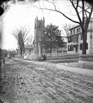
View from top of Unitarian Church on Middle Street looking southeast, showing the Fort and Ten Pound Island. Tappan Block and Main Street buildings between Center and Hancock in foreground.
Also filed under: Fort (The) and Fort Point » // Ten Pound Island »
Cape Ann Museum Library & Archive
Middle Street looking west. At the corner of Dale Avenue is the Sanders-Davidson house, later Sawyer Free Library. Also shown: Unitarian Church, Congregational Church.
Also filed under: Sanders-Davidson House »
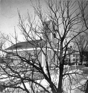
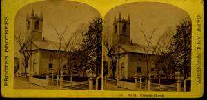
This large steepled building is Gloucester's Universalist Church. Universalism had found fertile ground here in Gloucester before the Revolution under the leadership of John Murray, who brought the teachings of James Relly from England in 1774. With adherents among the town's leaders such as Winthrop Sargent and his daughter, Judith Sargent Stevens Murray, it spread and flourished. The Gloucester adherents to Universalism refused to support quasi-governmental parish churches, specifically the First Parish in the Harbor district, and, speaking as well for all other non-parish churches, their dissent led to the Constitutional separation of Church and State. The first Universalist meetings were held on Sargent property at what was then Spring and Water Streets, now near the corner of Main and Duncan Streets. In 1805, under a new minister, Thomas Jones, this towering structure of the Universalist Church was erected by the local architect and builder, Jacob Smith.
The church's interior and foundation have been changed slightly since Lane's 1852 painting: in the 1860s, the foundation was raised seven feet to allow for a hall in the basement, and the lovely curved vestry staircases were installed. But the steeple remains as Smith, and Lane, saw it. It still houses a Paul Revere bell—for many years the only large bell in town. In 1852, this was the tallest structure on the skyline and a beacon to returning vessels. Its height was increased by the addition of a 'blind story' to the stack of belfry, lantern and cupola.
In 1852, the minister of the church was Amory D. Mayo, but in three years William R.G. Mellen would occupy the pulpit. He and his brother Charles Mellen were both Universalist ministers. Charles' wife was Mary Blood Mellen, Lane's student and copyist, but Charles was never a minister in Gloucester.
Current address: 50 Middle Street.
– Sarah Dunlap (May, 2014)
Cape Ann Museum Library & Archive
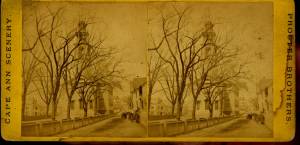
Stereo view of a front and side view of the Church, taken when there was no foliage upon the trees. Church street is also given throughout its length.
Also filed under: Historic Photographs »
1865 Stereograph card Cape Ann Museum Library & Archive
Also filed under: Historic Photographs »
44 x 34 in.
Henry Francis Walling, Map of the Towns of Gloucester and Rockport, Essex Co. Massachusetts. Philadelphia, A. Kollner, 1851
Cape Ann Museum Library & Archive
"Map of the Towns of Gloucester and Rockport, Massachusetts. H.F. Walling, Civil Engineer. John Hanson, Publisher. 1851. Population of Gloucester in 1850 7,805. Population of Rockport in 1850 3,213."

1834–35 24 x 38 in. Gloucester City Archives
"Drawn on a scale of one hundred feet to an inch. By John Mason 1834–45 from Actual Survey showing every Lott and building then standing on them giving the actual size of the buildings and width of the streets from the Canal to the head of the Harbour & part of Eastern point as farr as Smith's Cove and the Shore of the same with all the wharfs then in use. Gloucester Harbor 1834–35."
This map is especially helpful in showing the wharves of the inner harbor at the foot of Washington Street.
Also filed under: Dale, Eben B. » // Eastern Railroad » // Flake Yard » // Gloucester Harbor, Inner / Harbor Cove » // Hough, Benjamin Kent » // Maps » // Pavilion (Publick) Beach » // Ropewalk » // Sawyer, Samuel » // Town / Public Landings »

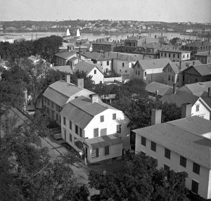
4 x 6 in.
Cape Ann Museum, Benham Collection
George Steele sail loft, William Jones spar yard, visible across harbor. Photograph is taken from high point on the Fort, overlooking business buildings on the Harbor Cove side.
Also filed under: Fort (The) and Fort Point » // Gloucester Harbor, Inner / Harbor Cove » // Town House » // Waterfront, Gloucester »
Ten Pound Island guards the entrance to Gloucester’s Inner Harbor and provides a crucial block to heavy seas running southerly down the Outer Harbor from the open ocean beyond. The rocky island and its welcoming lighthouse is seen, passed, and possibly blessed by every mariner entering the safety of Gloucester’s Inner Harbor after outrunning a storm at sea. Ten Pound Island is situated such that the Inner Harbor is protected from open water on all sides making it one of the safest harbors in all New England.
Legend has it that the island was named for the ten pound sum paid to the Indians for the island, and the smaller Five Pound Island deeper in the Inner Harbor was purchased for that lesser sum. None of it makes much financial sense when the entirety of Cape Ann was purchased for only seven pounds from the Indian Samuel English, grandson of Masshanomett the Sagamore of Agawam in 1700. From approximately 1640 on the island was used to hold rams, and anyone putting female sheep on the island was fined. Gloucester historian Joseph Garland has posited that the name actually came from the number of sheep pens it held, or pounds as they were called, and the smaller Five Pound Island was similarly named.
The island itself is only a few acres of rock and struggling vegetation but is central to the marine life of the harbor as it defines the eastern edge of the deep channel used to turn the corner and enter the Inner Harbor. The first lighthouse was lit there in 1821, and a house was built for the keeper adjacent to the lighthouse.
In the summer of 1880 Winslow Homer boarded with the lighthouse keeper and painted some of his most masterful and evocative watercolor views of the busy harbor life swirling about the island at all times of day. Boys rowing dories, schooners tacking in and out in all weather, pleasure craft drifting in becalmed water, seen together they tell a Gloucester story of light, water and sail much as Lane’s work did only several decades earlier.

Colored lithograph
Cape Ann Museum Library and Archive
Also filed under: Gloucester, Mass. - "Ten Pound Island Light »

Photograph
From The Illustrated Coast Pilot with Sailing Directions. The Coast of New England from New York to Eastport, Maine including Bays and Harbors, N. L. Stebbins, 1891.
Also filed under: Gloucester, Mass. - "Ten Pound Island Light »


Oil on canvas
22 x 36 in.
Cape Ann Museum, Gloucester, Mass., deposited by the Collection of Addison Gilbert Hospital, 1978 (DEP. 201)
Detail of party boat.
Also filed under: Party Boat »

Engraving of 1819 survey taken from American Coast Pilot 14th edition
9 1/2 x 8 in.
Cape Ann Museum Library & Archive
D32 FF5
Also filed under: Dolliver's Neck » // Eastern Point » // Maps » // Norman's Woe »
Newspaper
Gloucester Telegraph
"By the will of the late Fitz H. Lane, Esq., his handsome painting of the Old Fort, Ten Pound Island, etc., now on exhibition at the rooms of the Gloucester Maritime Insurance Co., was given to the town... It will occupy its present position until the town has a suitable place to receive it."
Stereograph card
Cape Ann Museum Library & Archive
View from top of Unitarian Church on Middle Street looking southeast, showing the Fort and Ten Pound Island. Tappan Block and Main Street buildings between Center and Hancock in foreground.
Also filed under: Fort (The) and Fort Point » // Unitarian Church / First Parish Church (Middle Street) »

1860 In John J. Babson, History of the Town Gloucester (Gloucester, MA: Procter Brothers, 1860) Cape Ann Museum Library & Archives, Gloucester, Mass.
See p. 474.
View related catalogue entries (4) »
Also filed under: Babson History of the Town of Gloucester » // Chebacco Boat / Dogbody / Pinky » // Fort (The) and Fort Point » // Gloucester Harbor, Inner / Harbor Cove » // Gloucester, Mass. - "Ten Pound Island Light » // Schooner (Coasting / Lumber / Topsail / Packet / Marsh Hay) »
The Ten Pound Island light was built on a three-and-a-half acre island at the eastern end of Gloucester Harbor. Built as a conical stone tower, the original 20-foot-tall Ten Pound Island Light was first lit in October, 1821 after the Commonwealth of Massachusetts and the Town of Gloucester ceded 1.7 acres to the U.S. Government for the construction of an inner harbor lighthouse to help mariners navigate the harbor. Ten Pound Island light was a popular subject with artists, including Winslow Homer, who boarded with the lighthouse keeper at Ten Pound Island in the summer of 1880. It is frequently featured in Lane's paintings of Gloucester Harbor.
This information has been shared with the Lane project by Jeremy D'Entremont. More information can be found at his website, www.newenglandlighthouses.net or in The Lighthouse Handbook New England. This information has also been summarized from Paul St. Germain's book, Lighthouses and Lifesaving Stations on Cape Ann.


Colored lithograph
Cape Ann Museum Library and Archive
Also filed under: Ten Pound Island »
Photograph
From The Illustrated Coast Pilot with Sailing Directions. The Coast of New England from New York to Eastport, Maine including Bays and Harbors, N. L. Stebbins, 1891.
Also filed under: Ten Pound Island »

Lang owned two drawings (made into paintings) to introduce the steamer "Harvest Moon." He was an owner of the Boston shipping firm of Spear, Lang, and Delano.
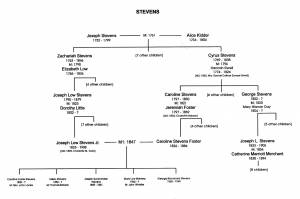
Caroline (Stevens) Foster Stevens (1826-1886) was the wife of Lane's good friend Joseph Stevens Jr. With her husband, she accompanied Lane on sketching expeditions around Gloucester. The back of indicates that it was a gift from Lane to Caroline Stevens in 1855. At his death, he left to her "the beautiful wreath of wax flowers (wrought by Mrs. Mary B. Mellen)."
The Gloucester family connections were many. Caroline and her husband were actually second cousins on the Stevens side. On the Foster side, Caroline's cousin, Julia Ann Foster, was married to Joseph Hooper, a friend of Joseph Stevens, Jr. and of Lane.
Caroline and Joseph had five children, one of whom died very young. Their daughter, Helen Stevens Babson, donated Dolliver's Neck and the Western Shore from Field Beach, 1857 (inv. 3) to the Cape Ann Museum.
Caroline and Joseph Stevens, Jr. are buried together in Oak Grove Cemetery in Gloucester; Lane is buried next to them.
Appendix G: Family Trees, in Sarah Dunlap and Stephanie Buck, Fitz Henry Lane: Family and Friends (Gloucester, MA: Church & Mason Publishing; in association with the Cape Ann Historical Museum, 2007), 164–66.
Also filed under: Stevens, Joseph, Jr. » // Stevens, Joseph, Sr. and Dorothy Little »
October 3, 1865 Essex County Probate Records, Volume 424, Leaves 34 & 35
The will disposed of Lane's property (including watch and diamond breast pin), his monetary assets, and gave to the city of Gloucester a painting of the Old Fort. Joseph Stevens, Jr. and T. Sewall Lancaster were named executors. It was signed by Lane on March 10, 1865.
Also filed under: Chronology » // Davidson, Dr. Herman Elvas » // Documents / Objects » // Funeral & Burial » // Galacar, Elizabeth » // Lancaster, T. Sewall » // Mellen, Mary Blood » // Page, Eben » // Stevens, Joseph, Jr. » // Wilbur, Horace B. »
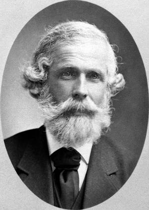
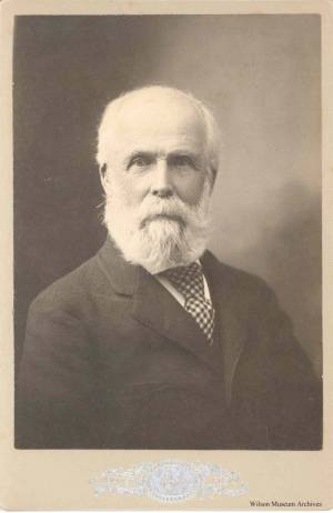
Joseph Lowe Stevens, Jr. (1823–1908) was Lane's closest friend and traveling companion. He was also executor of Lane's estate, and a tireless promoter of Lane's work. He was a supporter of abolition and animal welfare, and an active member of the Gloucester Lyceum. It was the Stevens family who encouraged Lane to make a print of Castine and who published and promoted it there Castine, from Hospital Island, 1855 (inv. 448). Joseph first worked as a dry goods salesman and in later life “engaged in the wholesale dry-goods and woollen trade on Summer St. Boston, travelling daily to and fro” on the train. (1)
Joseph's father, Dr. Joseph Lowe Stevens, Sr., was born in Andover, Massachusetts, and raised in Gloucester, Massachusetts. He married Dorothy Little of Castine, Maine, where the couple settled, and where Joseph Jr. was born in 1823. In the spring of 1840, at the age of seventeen, Joseph, Jr. left Maine and moved to Gloucester to work in his uncle’s Samuel Stevens' dry goods store and to live with his grandfather, Zachariah Stevens. Seven years later, Joseph, Jr. married his second cousin, Caroline Stevens Foster. The couple eventually had five children, one of whom died very young.
Like most of the educated population of the town, Joseph joined the Gloucester Lyceum shortly after arriving in town; the signature of John J. Piper appears next in the membership book; and the next after him was Fitz Henry Lane. (2) Joseph remained involved with the Gloucester Lyceum and Library for most of his life, acting as director for many years, and was the superintendent at the time it became incorporated as the Gloucester Lyceum and Sawyer Free Library.
Joseph also helped his father work on a history of Castine, and he was sufficiently concerned about the welfare of animals to serve on the boards of three animal-aid societies. He became the secretary of the Society for the Prevention of Cruelty to Animals and the New England Humane Education Society, and treasurer of the Band of Mercy. (3) Joseph was committed to more than animal welfare; he involved himself in the Free Soil movement and the slavery debate, to the extent that he left Gloucester for Kansas in 1855 “to see for himself what was going on,” returning about two years later. (4)
Joseph L. Stevens, Jr. first became friends with Lane after the artist had returned from Boston and had set up a studio on Elm Stree. That same year, Joseph invited Lane to accompany him to Castine. It was the first of many such trips to the Maine coast, where Lane sketched and painted and visited with Joseph’s parents.
When Lane fell out with his brother-in-law, Joseph Stevens came to the rescue by purchasing the contested stone house from Lane and evicting the troublesome in-laws. He was also at Lane’s side when he died and was named as one of two executors in Lane’s will. In addition, he inherited two-thirds of the residual property of the estate.
Joseph’s wife Caroline died in 1886, and Joseph left Gloucester nine years later to marry Charlotte M. Todd of Milton. He remained there until his own death. He is buried in Oak Grove cemetery alongside Caroline and their infant son. Lane is also buried in their family plot.
– Stephanie Buck
(1) Joseph L. Stevens Jr., letter written as Superintendent of the Sawyer Free Library, for the 1876 Women’s Time Capsule. Gloucester Archives, CC195 and AS300.
(2) Gloucester Lyceum Records, vol. 1, 1830–1852.
(3) The New England Humane Education Society is not to be confused with the coastal lifesaving institution which was then known as the Massachusetts Humane Society. The Band of Mercy was associated with the Massachusetts SPCA.
(4) F. A. Sharf, "Fitz Hugh Lane: Visits to the Maine Coast, 1848–1855," Essex Institute Historical Collection 98, no. 2 (April 1962): 112.
n.d. Photograph Wilson Museum, Castine, Maine (a02156)
Also filed under: Historic Photographs »
Newsprint
Gloucester Daily Telegraph
Article by Joseph L. Stevens
"The beauties of this place [Maine] are well known and appreciated among artists. We heard of Bonfield and Williams who had reluctantly left but a short time before. Fishe had spent several weeks there. Champney and Kensett were then in another part of the island, and we have reason to believe that Church and some others were in the immediate vicinity–Lane who was with us, made good additions to his portfolio."
Personal journal
Wilson Museum, Castine, Maine
Box 2, F1 (A00772)
John Stevens was the younger brother of Joseph Stevens, and acquainted with Lane, spending time with him in Gloucester and at the family home in Castine. His journal, quoted below, includes reference to hunting plover and teal, school, sailing, local events. Mentions Castine mill, lighthouse, and block house.
"Friday [September] 17th: Cloudy all day. Wind N. blowing quite hard. A British Rig loaded with salt from Liverpool came into port last night. She run way up by the Monument and got aground. They kedged her off this P.M. and came down. She came in with one of these old English charts as her guide. They have the town set down on the Brooksville side, two miles + three quarters from the lighthouse."
"Wednesday [September] 22. . .Went down to the Indians Camp on the Back Cove. There were five camps of them."
Visits Gloucester from Castine:
"Wednesday [October] 27th. . .Left for Gloucester [from Boston] at 5 o'clock this P.M. arrived there safe + sound at 6 1/2 o'clock; went right down to the store and saw Joe. We then went up to his house and got supper.
"Thursday [October] 28th. At. Gloucester. Pleasant day. Went down to the "Cut" a gunning this morning before breakfast but saw no birds. Went out in the harbor this forenoon alone, had a fine sail but couldn't get a chance at any birds. Went out again this P.M. got down to East Point Light and the wind died all away, so I had to scull home."
"Friday 29th. Very pleasant day, went out in the harbor this morning with Joe. Took a walk this A.M. with "Lina", called on Mr. Lane + Doct. Hildreth. Joe + I went out in the harbor this P.M. I fired at some birds several times, but didn't get any. . . ."
Also filed under: Biographical information » // Bird Hunting » // Castine » // Castine – School » // Chronology » // Cut, The (Stacy Blvd.) » // Diaries / Ledgers / Etc. »
Newspaper
Gloucester Telegraph
"Ignatius Winter v. Joseph L. Stevens, Jr.—This was an action of tort brought by the plaintiff to recover damages for personal injury in ejecting him from his dwelling house, as the plaintiff claimed. Defendant justified his expulsion of the plaintiff on the ground that he expelled him from his own, the defendant's house, using no more force than was reasonably necessary to accomplish this."
Also filed under: Newspaper / Journal Articles » // Winter, Ignatius »
Samuel Sawyer Papers
Cape Ann Museum Library & Archives
Archive Collection
"Met Mr. Tuckerman the artist walking with Jos. Stevens."
Also filed under: Diaries / Ledgers / Etc. » // Sawyer, Samuel » // Tuckerman, Stephen Salisbury »
Newspaper
Letter to the editor: "Fitz H. Lane's will and gift of the Old Fort painting in the Town Hall, sketched in 1859, from T. Sewell Lancaster and Joseph L. Stevens, executors."
Reply from Selectmen: "Mr. Lane was much esteemed by his townsmen not only for his skill as an artist, but also for his character, as a gentleman of Honor and Integrity."
Also filed under: Biographical information » // Funeral & Burial » // Lancaster, T. Sewall » // Newspaper / Journal Articles »
Handwritten list
Wilson Museum, Castine, Maine (A00787-1a-1d)
Also filed under: Castine » // Castine – Witherle & Co.'s Store » // Lithography (Sales & Exhibitions) » // Noyes, Samuel » // Publications » // Witherle, William Howe »
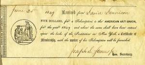
Printed paper receipt with handwritten entries by Joseph L. Stevens, Jr.
Cape Ann Museum, Gloucester, Mass.
Also filed under: New York – American Art Union »
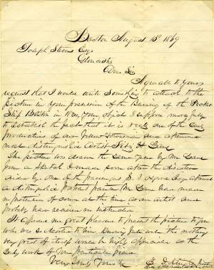
Letter regarding the burning of the packet ship "Boston"
Cape Ann Museum, Gloucester, Mass.
"Dear Sir, Agreeable to your request that I would write something to attach to the picture in your possession of the Burning of the Packet Ship Boston in 1830, your object I suppose more fully to establish the fact that it is really one of the early productions of our fellow townsman and afterward most distinguished artist Fitz H. Lane.
The picture was drawn the same year by Mr. Lane from a sketch I made soon after the disaster aided by one of the passengers S.S. Osgood Esq. afterward a distinguished portrait painter. Mr. Lane had made not reputation of course at this time as an artist. And probably had received no instruction. It afforded me great pleasure to present this picture to you who was so devoted to him, knowing full well tho nothing very great of itself would be highly appreciative [...] as the early work of that [...] particular friend."
Also filed under: "Boston" (Packet Ship) » // Knight, Elias Davis » // Letters »
Letter
Cape Ann Museum Library & Archive, Gloucester, Mass.
". . . will fully appreciate all that I have done in my garden, in ornamenting it, with flowers and plants, Rustic Arbours and Statues, and I only wish that you could be here to witness and enjoy his [Dr. J. L. Stevens] expressions of delight and interest, when a new flower attracts his attention, or some beauty of arrangement meets his eye. Samuel [B. Stevens of Castine] he tells me came up with the expectation of going on a voyage to Australia, but when he arrived in Boston he found the vessel with her compliment of men, and it is very uncertain if he goes in her. Your Mother and all at home are well. I yesterday made a sketch of Stage Fort and the surrounding scenery, from the water. Piper has given me an order for a picture from this point of view, to be treated as a sunset. I shall try to make something out of it, but it will require some management, as there is no foreground but water and vessels. One o’clock, it is very hot, the glass indicates 84° in my room, with the windows all open and a light breeze from the east, this is the warmest day . . .
. . . than devoting it to you. Since writing you last I have painted but one picture worth talking about and that one I intend for you if you should be pleased with it. It is a View of the beach between Stage Fort and Steep bank including Hovey’s Hill and residence, Fresh water cove and the point of land with the lone pine tree. Fessenden’s house, likewise comes into the picture. The effect is a mid day light with a cloudy sky, a patch of sunlight is thrown across the beach and the breaking waves, an old vessel lies stranded on the beach with two or three figures, there are a few vessels in the distance and the Field rocks likewise show at the left of the picture. I think you will be pleased with this picture, for it is a very picturesque scene especially the beach, as there are many rocks which come in to destroy the monotony of a plain sand beach, and I have so arranged the light and shade that the effect I think is very good indeed, however you will be better able to judge of that when you see it, the size is 20 x 33. . ."
Letter
Castine Historical Society, Maine
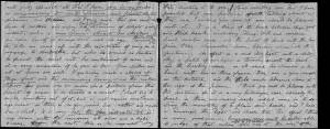
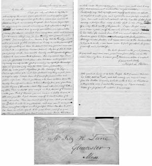
"[John] says Charles proposes to come down on Saturday—to return on Monday—so that may be so—I think of defering sending the pictures till then—it has been my intention to have sent them tomorrow. [??] went away on Monday last before I had time to have them boxed. Mr. Noyes will see to that. The have been, for a day or two, in Witherle & Co.'s store, where they were much admired—& a little remarkable, among the visitors there yesterday was Mr. King—the son of the Keeper of the Light—who was engaged in catching herring while you was at the Rock. He was very much pleased—thought it as natural as life—as it was to his recollection—having only left there a week since. He observed that he would not have believed Mr. Lane had so much in him. In case Charles does not come on Saturday how shall I direct the box—for I shall send it by express to Boston—I don't remember any thing was said about that. I hope you will come over to Owl's Head, as proposed—if so, you & Lane must come & spend one night at least. Our two teacher boarders came in the boat that took you away—but we can continue to accommodate some way or other. Mary is to leave on Monday next."
1903 Four-page letter Collection of the Cape Ann Museum Library & Archive, Gloucester, Mass.
"[The painting] is offered you for $150 on as long time and in as many notes at 3% interest as you choose. . . I believe this to be the only important painting of Gloucester Harbor that Lane never duplicated. . . .Returning from a Gloucester visit while I was still under the roof there, father brought a print of Lane's first Gloucester view, bought of the artist at his Tremont Temple studio in Boston. An extra dollar had been paid for coloring it. For a few years it was a home delight.. . .I had been a few years in Gloucester when Lane began to come, for part of the time a while, if I remember rightly. He painted in his brother's house, "up in town" it then was. I recall visits there to see his pictures. But it was long after, that I could claim more than a simple speaking acquaintance. The Stacys were very kind, aiding him as time went on in selling paintings by lot. I invested in a view of Gloucester from Rocky Neck, thus put on sale at the old reading room, irreverently called "Wisdom Hall." And they bought direct of him to some extent, before other residents. Lane was much my senior and yet we gradually drifted together. Our earliest approach to friendship was after his abode began in Elm Street as an occupant of the old Prentiss [sic-corrected Stacy] house, moved there from Pleasant. I was a frequenter of this studio to a considerable extent, yet little compared with my intimacy at the next and last in the new stone house on the hill. Lane's art books and magazines were always at my service and a great inspiration and delight—notably the London Art Journal to which he long subscribed. I have here a little story to tell you. A Castine man came to Gloucester on business that brought the passing of $60 through my hands at 2 1/2 % commission. I bought with the $1.50 thus earned Ruskin's Modern Painters, my first purchase of an artbook. I dare say no other copy was then owned in town. . . .Lane was frequently in Boston, his sales agent being Balch who was at the head of his guild in those days. So in my Boston visits – I was led to Balch's fairly often – the resort of many artists and the depot of their works. Thus through, Lane in various ways I was long in touch with the art world, not only of New England but of New York and Philadelphia. I knew of most picture exhibits and saw many. The coming of the Dusseldorf Gallery to Boston was an event to fix itself in one's memory for all time. What talks of all these things Lane and I had in his studio and by my fireside!
For a long series of years I knew nearly every painting he made. I was with him on several trips to the Maine coast where he did much sketching, and sometimes was was [sic] his chooser of spots and bearer of materials when he sketched in the home neighborhood. Thus there are many paintings whose growth I saw both from brush and pencil. For his physical infirmity prevented his becoming an out-door colorist."
1871 Photograph Maine Historic Preservation Commission (2000.24)
Also filed under: Castine – Stevens Home » // Historic Photographs » // Stevens, Joseph, Sr. and Dorothy Little »
Single sheet, writing both sides
Cape Ann Museum Library & Archives, Gloucester, Mass.
"My dear Sir,
I hope you will not attribute the delay in acknowledging the receipt of your splendid, and most unexpected Gift to a want of a due appreciation of it. Many reasons have consipired to prevent my doing it – unnecessary to repeat. But I can no longer defer the expressions of our warmest acknowledgements for a present in itself so valuable, and endeared to us by many associations, as a representation of scenery often admired, and which I have many times wished could be transferred to canvas, although vary far from thinking that wish would ever be gratified. You must premit me, however, to say that the Painting, valuable as it is as a work of Art, and pleased as I may be as the possessor of it, is less appreciated by us than the delicate and very generous manner in which its acceptance has been tendered. My love of Art, to which you do politely allude, I am sensible has only wanted opportunity of indulgence to have amounted to a passion. From my earliest days I have wished for opportunities to visit places, where that desire could be gratified, and my reading has only had the effect of increasing my regrets for the want of them, and of encouraging envy for those more fortunate - I feel, too, under great obligations for the Drawing of the "Siege"(1) – I had no expectations you could have produced anything so good from so rough a copy. I shall have it framed for presentation and future reference. Several gentlemen who have called in to see the painting have expressed a desire to have a drawing from you of our town, similar to yours of Gloucester, which they much admire, and of lithographs, I have no doubts copies enough could be disposed of to remunerate you. That of Homans you are aware is feebly drawn, & still worse printed. I feel desirous myself it should be done, if it suits your wishes. There are several points of view, which you did not see, & to which it will be my pleasure, next summer, to carry you. I know many of our citizens would be gratified to have this done by you. Our house we shall expect to be your home, and if, as you suggested in Gloucester, you should come in your Boat, this place could be made the rendezvous, from whence you could start to any place that convenience & inclination might dictate – . . . Permit me again to tender acknowledgements for the picture. It hangs in our parlor, & I never come in to the house, without looking in to see it, & can never cease to feel grateful for your generosity and politeness. "
(1) Joseph Stevens was very interested the Revolutionary war event known as the "Penobscot Expedition" or the "Siege of Castine" by the British on July 25, 1779. In 1852 he handwrote an account of it and many articles are in the family's scrapbook at the Wilson Museum in Castine.
View related catalogue entries (2) »
Also filed under: Castine » // Homan, S.V. » // Letters » // Stevens, Joseph, Sr. and Dorothy Little »
Appendix G: Family Trees, in Sarah Dunlap and Stephanie Buck, Fitz Henry Lane: Family and Friends (Gloucester, MA: Church & Mason Publishing; in association with the Cape Ann Historical Museum, 2007), 164–66.
Also filed under: Stevens, Caroline Foster » // Stevens, Joseph, Sr. and Dorothy Little »
Personal notebook
Wilson Museum, Castine, Maine
Note about historical importance of this Castine landmark: "On Saturday afternoon, August 11, 1855, with my friend the marine artist Fitz. H. Lane of Gloucester" visited Trask's Rock
Also filed under: Biographical information »
October 3, 1865 Essex County Probate Records, Volume 424, Leaves 34 & 35
The will disposed of Lane's property (including watch and diamond breast pin), his monetary assets, and gave to the city of Gloucester a painting of the Old Fort. Joseph Stevens, Jr. and T. Sewall Lancaster were named executors. It was signed by Lane on March 10, 1865.
Also filed under: Chronology » // Davidson, Dr. Herman Elvas » // Documents / Objects » // Funeral & Burial » // Galacar, Elizabeth » // Lancaster, T. Sewall » // Mellen, Mary Blood » // Page, Eben » // Stevens, Caroline Foster » // Wilbur, Horace B. »
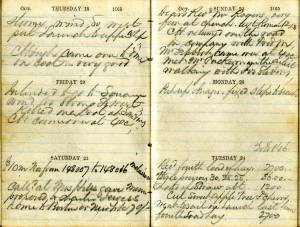
Personal diary
Wilson Museum, Castine, Maine (A00060-1a-1h)
Description of an excursion taken by Joseph Stevens, Jr., Lane, Witherle, Samuel Adams, Jr., and George Tilden around the islands of Maine near Mt. Desert. The group hired the Sloop "Superior" which was owned by Pilot Getchell. In his diary, Witherle mentions multiple times that "Lane took a sketch" especially when the water was calm. Lane often stayed on board the boat, while the others went ashore.
Excerpts of the diary include:
August 16: "Lane has a knack for frying fish."
August 17: "leaving Lane to take a sketch, we took a climb."
August 19: "went to ascend one of the highest mountains. 3/4 the way up we had to wait – once in a while for Lane who with his crutches could not keep up with us – but got along faster than we thought possible . . .Lane got up about an hour after the rest of us."
The entire text is transcribed in an account published by the Wilson Museum.
Marks: Inscribed upper left (in red ink): 43 [numbering system used by curator A. M. Brooks upon Samuel H. Mansfield's donation of the drawings to the Cape Ann Museum]