loading 
Fitz Henry Lane
HISTORICAL ARCHIVE • CATALOGUE RAISONNÉ • EDUCATIONAL RESOURCE
An online project under the direction of the CAPE ANN MUSEUM
An online project under the direction of the CAPE ANN MUSEUM
Catalog entry
inv. 145
Sketch from Gloucester Outer Harbor
1863 Graphite on paper (3 sheets) 10 5/8 x 43 1/4 in. (27 x 109.9 cm) Inscribed lower center (in pencil): Sketch from Gloucester Outer Harbor by F.H. Lane 1863; Inscribed lower right (in pencil): F.H.L. / J.L.S. Jr. / C.S. / H.S. / G.F.
|
Supplementary Images
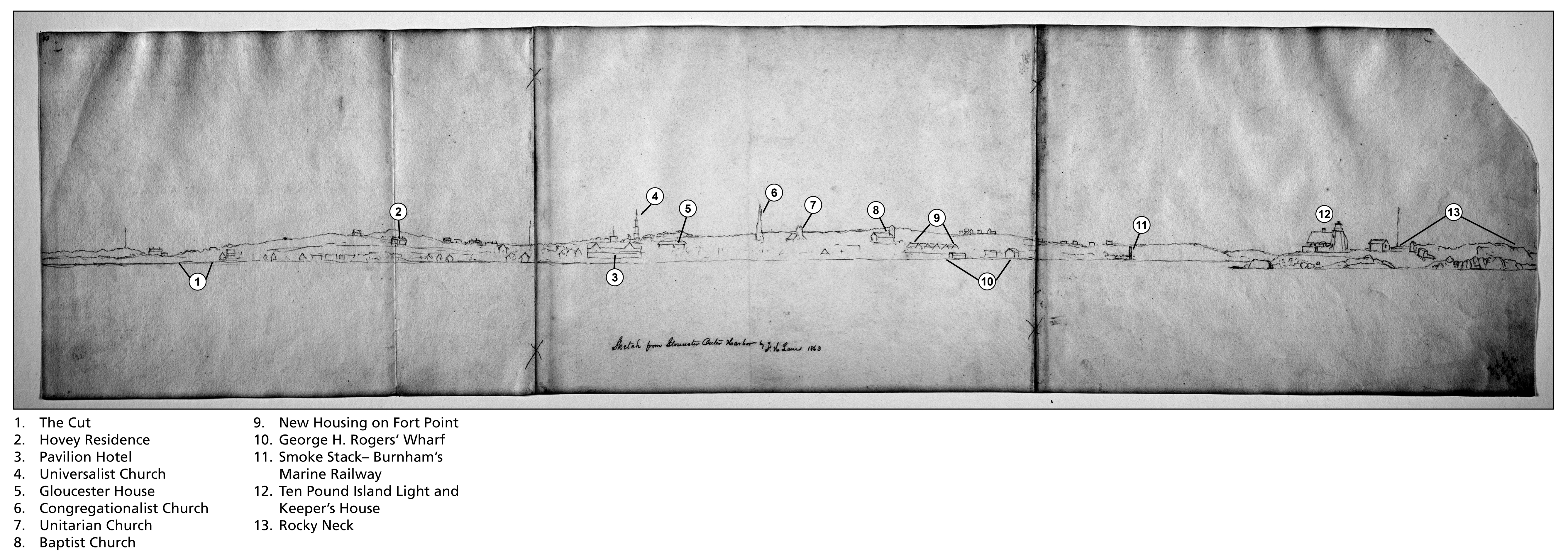
Drawing with key buildings identified
Photo: © Erik Ronnberg
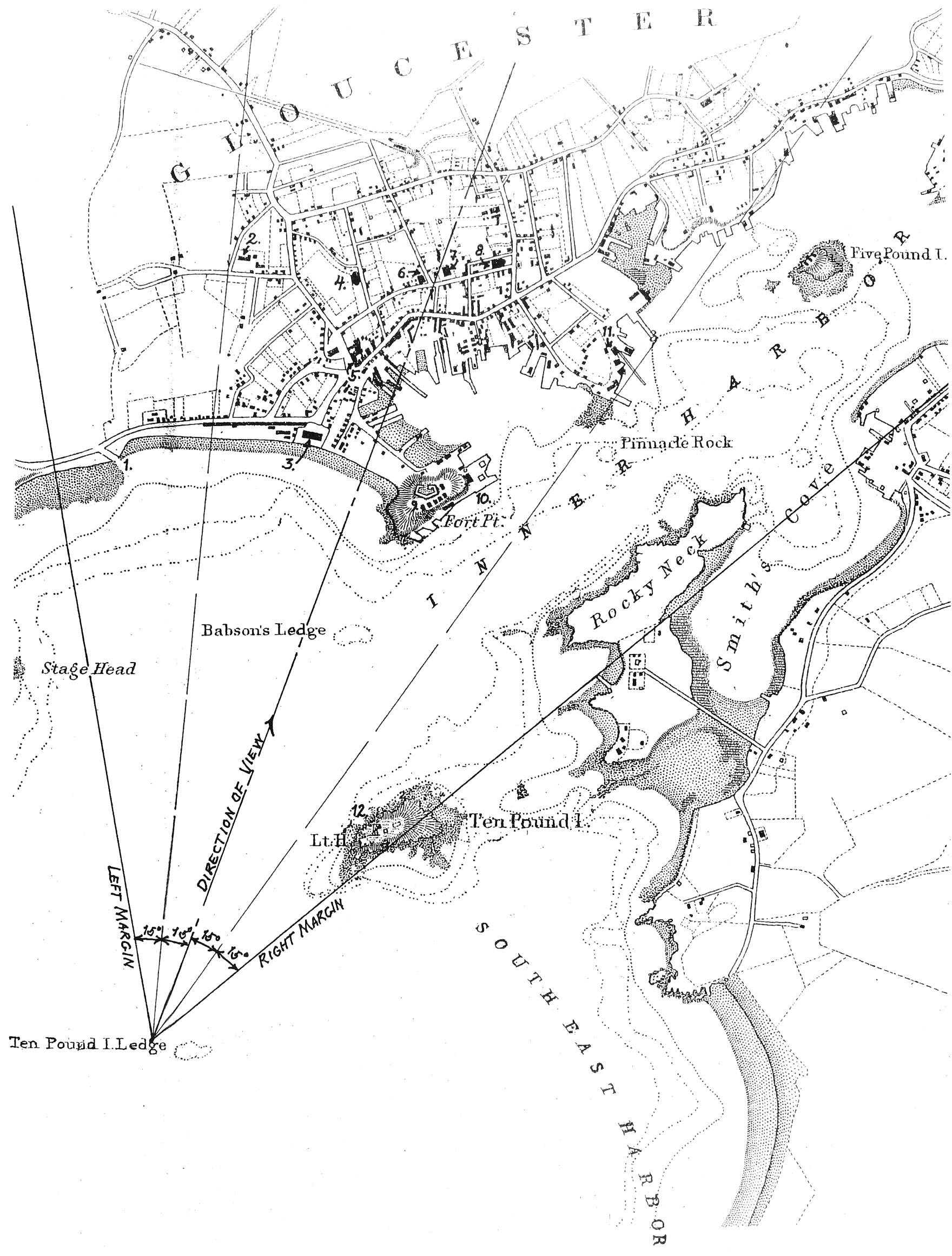
Viewpoint map showing Lane's location when making this drawing
Photo: © Erik Ronnberg/U.S. Coast Survey
Provenance (Information known to date; research ongoing.)
the Artist, Gloucester, Mass.
Joseph L. Stevens, Jr., Gloucester, Mass.
Samuel H. Mansfield, Gloucester, Mass.
Cape Ann Museum, Gloucester, Mass., 1927
Marks & Labels
Marks: Inscribed upper left (in red ink): 43 [numbering system used by curator A. M. Brooks upon Samuel H. Mansfield's donation of the drawings to the Cape Ann Museum]
Exhibition History
No known exhibitions.Published References
Paintings and Drawings by Fitz Hugh Lane. Gloucester, MA: Cape Ann Historical Association, 1974., fig. 79.
Commentary
While its detail has been lightly drawn and highly abbreviated, this drawing offers a panoramic view of the northeast end of Gloucester Harbor from the Cut to Head of the Harbor – the latter partially obscured by Ten Pound Island and Rocky Neck. The shore line and direction of view are similar to A Barque with Shortened Sail at End of Storm, 1860 (not published) which takes in much of the same skyline, but from a slightly different viewing point. Both images are part of a group of Lane’s work which look back toward the town from viewing points around the Outer Harbor, especially its western shore (Gloucester Harbor, 1852 (inv. 38), Gloucester from Brookbank, 1848 (inv. 42), Gloucester Harbor, 1856 (inv. 75), Early Morning, Pavilion Beach, Gloucester, c.1850–55 (inv. 78), and View of Gloucester from "Brookbank," the Sawyer Homestead, c.1856 (inv. 95)). This drawing is one of his few such depictions as seen from the water.
In A Barque with Shortened Sail at End of Storm, 1860 (not published), the angle of view was found to be 60 degrees from a viewing point close to Ten Pound Island and even closer to Ten Pound Island Ledge. Using the same 60 degree angle (divided into four 15 degree segments), and moving the viewing point west, slightly beyond Ten Pound Island Ledge, it was found to cover the breadth of the drawing with the identified objects close to – often exactly on – their positions in the U.S. Coast Survey chart used in this exercise. These objects are identified by number on a high-contrast image of the drawing and on the viewpoint map derived from the survey chart:
The Cut (1), where the Annisquam River meets Gloucester Harbor was formerly an isthmus which was periodically opened and bridged, refilled and reopened, until finally made a permanent bridged waterway in 1868.
The summer residence of Charles Hovey (2) was built 1847 on Babson’s Hill, overlooking Pavilion Beach. Hovey was a wealthy Boston merchant, an early summer resident, and an early user of the railroad connection to Gloucester to commute to his office in Boston.
The Pavilion Hotel (3) was built in 1849 by Sidney Mason, a Gloucester native and New York merchant, to provide pleasant lodging for Cape Ann’s summer visitors.
The Independent Christian Church, Universalist (4), at the corner of Middle and Church Streets, was built in 1805 and stands today. Its steeple – long the tallest in Gloucester – made it a useful guide to vessels entering the harbor prior to the building of lighthouses.
The Gloucester House (5), a brick building at the corner of Washington and Front (now Main) Streets, was one of the earliest hotels established for year-round operation, catering to visitors on business.
Trinity Congregational Church (6), rebuilt after a fire in 1854, had for eleven years the tallest steeple in Gloucester, although not with a lantern at its peak. The steeple was replaced by an elaborate belfry.
The Unitarian (formerly First Parish) Church (7) was built in 1828 and given a bell tower with four short spires on its corners.
The Second Baptist Church (8) was built in 1851 in response to a rapidly growing congregation. Built of wood, it was painted a reddish brown to resemble a brick structure.
Residential buildings on Fort Point (9) block a southern view of the remains of Fort Defiance in what is so far Lane’s earliest depiction of them. The development of Fort Point began in the late 1840s when George H. Rogers started building a large wharf on its east side, followed in the 1850s by two finger piers along the south side. Surviving floor plans of the five houses depicted by Lane suggest that they were double-occupancy tenements.
George H. Rogers’ wharf complex (10) was begun in 1848 with the construction of a stone bulkhead pier on Fort Point’s East side. Intended for serving his interests in the Surinam Trade, it was soon used mainly for the fisheries.
A smoke stack rises over the site of Burnham Brothers’ marine railway (11), an area formerly used for shipbuilding until c.1849–50, when a marine railway was built and the firm was devoted entirely to vessel maintenance.
Ten Pound Island Light House (12) was built in 1821 – the first light house to mark the entrance to Gloucester Harbor.
Rising beyond and above Ten Pound Island, Rocky Neck (13) is more an island connected by a narrow causeway. Long used as pasture land, it was only beginning to become a business and residential area in the 1860s.
–Erik Ronnberg
References:
1. Joseph E. Garland, “The Gloucester Guide” (Rockport, MA: Protean Press, 1990).
2. Mary Ray (Compiler) and Sarah Dunlap (Editor), “Gloucester Massachusetts Historical Time Line” (Gloucester, MA: Gloucester Archives Committee, 2002).
The initials in the lower right corner are thought to indicate Lane, his friend Joseph Stevens, Jr. and his wife Caroline, and their daughter Helen, probably his companions on this outing. The identity of G.F. has not been determined.