An online project under the direction of the CAPE ANN MUSEUM
Catalogue Entry
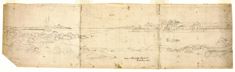
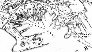
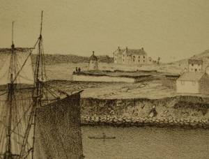
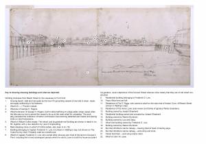
From the perspective of Duncan's Neck, this drawing shows Gloucester's Inner Harbor. Ten Pound Island and the lighthouse are to the left, while George Rogers's large commercial building, his rapidly expanding wharf, and the windmill, which had recently been moved here from its original location near Pavilion Beach, are just to the right of the center of the composition. The architectural element behind Rogers's building is most likely the Fort.
Lane used three pieces of paper to compose this drawing, which served as a sketch for Gloucester Inner Harbor, 1850 (inv. 240). The notable difference between the two pictures is the absence of vessels in the drawing. This is typical of Lane's drawings—he often recorded only the landscape features in his pencil drawings or in the underdrawings of paintings, adding the vessels in the final stages. That he intended to add the fleet of fishing schooners present in the painting is indicated, however, by the diagonal perspective lines in this drawing, which would help him to represent the vessels in the proper proportions.
This drawing is also useful in the way in which it shows the development of George H. Rogers's wharf. Rogers was a merchant and owner of a great deal of the waterfront. He was known for the huge wharf he constructed in the Inner Harbor. In this drawing it is under construction—a derrick used to drive wharf pilings can be seen behind the left side of the wharf. Erik Ronnberg has documented the growth of the harbor and Rogers's wharves in an essay for the Cape Ann Museum.
The three sheets of paper are glued together to make a drawing surface 9 1/2” high by 34 3/4” wide. The drawing's width is almost exactly the same as the bottom of the painting, which measures 36". A horizon line was drawn over the assembled sheet’s whole width (it can be seen over its whole length under magnification). Pin pricks were made every 4 1/16” on this line—seven in all, dividing the sheet into eight equal segments. The care taken in this process raises questions over what kind of viewing device Lane was using to warrant this effort and that permitted such remarkable accuracy in his placement of landmarks and buildings. To date, nothing has been found regarding Lane’s training or use of viewing instruments for this purpose, which should prompt examination of the kinds of tools and methods then available.
If Lane’s accuracy of proportion and detail in man-made structures is impressive, it is no less so in his renderings of the natural surroundings. The rock formations along the foreground shoreline are carried over stone-for-stone to the painting, implying his intent on rendering the whole scene exactly as he saw it. Without all the vessels included in the painting, it is possible to look out to the entrance to Gloucester Harbor and see many coastal features lining both sides.
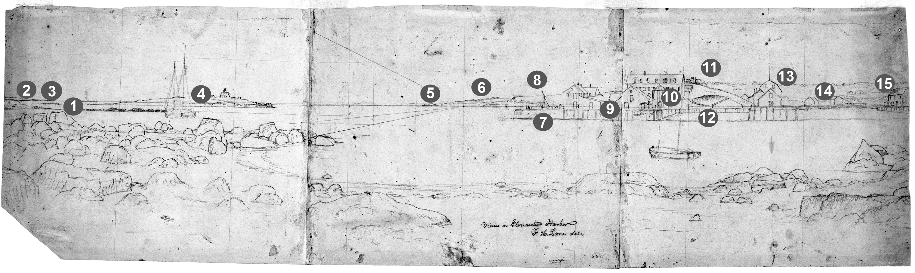
A Visual Guide to the Painting
- The northeastern end of Rocky Neck and its extension, Black Rock, which was exposed at low tide.
- Eastern Point, the lighthouse of which is just beyond the drawing’s left margin (which was trimmed at some unknown date prior to its donation to Cape Ann Museum).
- Black Ledge, which lies between Rocky Neck and Ten Pound Island and is exposed at low tide.
- Ten Pound Island and its lighthouse.
- Norman’s Woe Rock.
- Dolliver’s Neck.
- Stone bulkhead pier at the southeast corner of George H. Rogers’s wharf. At the time of drawing, this part of the wharf was incomplete, awaiting a timber wharf extension on spiles (pilings) to be built out from it.
- Atop the bulkhead pier, a pile-driving hammer is setting fender spiles along the side that faces the Outer Harbor.
- The east side of Rogers’s wharf, showing the completed part of the timber wharf extension.
- Ignatius Webber’s windmill, moved from the site of the Pavilion Hotel, which was then under construction.
- Fort Defiance (remains of).
- Bulkhead pier (cob wharf construction) between the wharves of George H. Rogers and John. W. Lowe.
- Wharf and buildings of John W. Lowe.
- Pavilion Beach—still used as a flake yard occupied by fishermen’s shacks and fish flakes (fish drying racks).
- Wharf of the estate of I. J. Procter.
– Erik Ronnberg
- Subject Types
: - Cape Ann Locales
:
Historical Materials

1834–35 24 x 38 in. Gloucester City Archives
"Drawn on a scale of one hundred feet to an inch. By John Mason 1834–45 from Actual Survey showing every Lott and building then standing on them giving the actual size of the buildings and width of the streets from the Canal to the head of the Harbour & part of Eastern point as farr as Smith's Cove and the Shore of the same with all the wharfs then in use. Gloucester Harbor 1834–35."
This map is especially helpful in showing the wharves of the inner harbor at the foot of Washington Street.
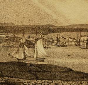
George H. Rogers was one of Gloucester's most enterprising citizens of the mid-nineteenth century. In the early 1830s, he ventured into the Surinam trade with great success, leading him to acquire a wharf at the foot of Sea Street. Due to Harbor Cove's shallow bottom at low tide, berthings at wharves had to be done at high tide, leaving the ships grounded at other times. Many deep-loaded vessels had to anchor outside Harbor cove and be partially off-loaded by "lighters" (shallow-draft vessels that could transfer cargo to the wharves) before final unloading at wharfside. To lessen this problem, Rogers had an unattached extension built out from his wharf into deeper water (see The Fort and Ten Pound Island, Gloucester (Harbor Scene), 1848 (inv. 58), right middle ground). The space between the old wharf and the extension may have been a way to evade harbor regulations limiting how far a pier head could extend into the harbor. Stricter rules were not long in coming after this happened!
About 1848, Rogers acquired land on the east end of Fort Point, first putting up a large three-story building adjacent to Fort Defiance, then a very large wharf jutting out into Harbor Cove. Lane's depictions of Harbor Cove and Fort Point show progress of this construction in 1848 (The Fort and Ten Pound Island, Gloucester (Harbor Scene), 1848 (inv. 58)), 1850 (Gloucester Inner Harbor, 1850 (inv. 240)), and c.1851 (Gloucester Harbor at Dusk, c.1852 (inv. 563)). A corner of the new wharf under construction can also be seen more closely in Ten Pound Island, Gloucester, 1850s (inv. 17) and Ten Pound Island in Gloucester Harbor, 1864 (inv. 104) (foregrounds). This new wharf provided better frontage for large ships to load and unload, as well as larger warehouses and lofts for storage of goods and vessel gear.
By 1860, Rogers was unloading his Surinam cargos at Boston, as ever-larger ships and barks were more easily berthed there. His Gloucester wharves continued to be used for deliveries of trade goods by smaller vessels. In the late 1860s, Rogers' wharf at Fort Point (called "Fort Wharf" in Gloucester directories) was acquired by (Charles D.) Pettingill & (Nehemiah) Cunningham for use in "the fisheries" as listed by the directory. in 1876, it was sold to (John J.) Stanwood & Company, also for use in "the fisheries." (1)
Lowe's Wharf, adjacent to Fort Wharf, was acquired by (Sylvester) Cunningham & (William) Thompson, c.1877 and used in "the fisheries" as well. That wharf and its buildings were enlarged considerably as the business grew. By this time, Harbor Cove was completely occupied by businesses in the fisheries or providing services and equipment to the fishing fleet. In photographs of Fort Point from this period, it is difficult to distinguish one business from another, so closely are they adjoined.
– Erik Ronnberg
Reference:
1. A city atlas, dated 1899, indicates that Rogers's wharf at Fort Point was still listed as part of his estate. If so, then Stanwood & Co. would have been leasing that facility from the Rogers's estate.
44 x 34 in.
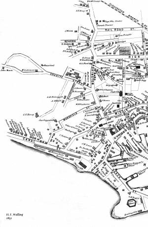
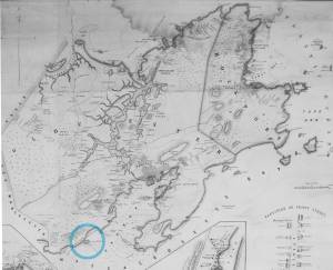
Henry Francis Walling, Map of the Towns of Gloucester and Rockport, Essex Co. Massachusetts. Philadelphia, A. Kollner, 1851
Cape Ann Museum Library & Archive
"Map of the Towns of Gloucester and Rockport, Massachusetts. H.F. Walling, Civil Engineer. John Hanson, Publisher. 1851. Population of Gloucester in 1850 7,805. Population of Rockport in 1850 3,213."
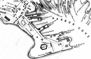
Segment of Harbor Village portion of map showing Low's, Rogers', and other wharves in the Inner Harbor.
Also filed under: Low (Frederick G.) wharves »
44 x 34 in.
Henry Francis Walling, Map of the Towns of Gloucester and Rockport, Essex Co. Massachusetts. Philadelphia, A. Kollner, 1851
Cape Ann Museum Library & Archive
"Map of the Towns of Gloucester and Rockport, Massachusetts. H.F. Walling, Civil Engineer. John Hanson, Publisher. 1851. Population of Gloucester in 1850 7,805. Population of Rockport in 1850 3,213."

44 x 34 in.
John Hanson, Publisher
Cape Ann Museum Library & Archive
"Map of the Towns of Gloucester and Rockport, Massachusetts. H.F. Walling, Civil Engineer. John Hanson, Publisher. 1851. Population of Gloucester in 1850 7,805. Population of Rockport in 1850 3,213."
Also filed under: Fort (The) and Fort Point » // Low (Frederick G.) wharves » // Maps » // Town / Public Landings » // Waterfront, Gloucester » // Windmill »

1865 41 x 29 inches Courtesy of the Massachusetts Archives Maps and Plans, Third Series Maps, v.66:p.1, no. 2352, SC1/series 50X
.
Also filed under: Burnham Brothers Marine Railway » // Collins's, William (estate wharf) » // Gloucester Harbor, Inner / Harbor Cove » // Maps »

1876 Photograph Cape Ann Museum Library & Archive
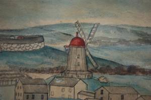
Ignatius Weber's windmill (now defunct) is shown.
Also filed under: Flake Yard » // Fort (The) and Fort Point » // Gloucester Harbor, Inner / Harbor Cove » // Historic Photographs » // Schooner (Fishing) » // Waterfront, Gloucester » // Windmill »
A grist windmill, originally owned by Ignatius Webber and then by Sidney Mason's father, John Mason, had stood on the hill since 1814, but, in preparation for the Pavilion Hotel, was moved to the inner-harbor side of the old Fort and eventually burned in 1877. Lot on which it stood by the water was sold to Sidney Mason in 1846. The windmill can be seen in several Lane harbor paintings and drawings.
Ignatius Webber’s windmill in its original location appears in View of the Town of Gloucester, Mass., 1836 (inv. 437) (far left, very small, with vanes), and View of Gloucester, (From Rocky Neck), 1846 (inv. 92) (also far left, a bit larger, but without vanes). After its move to Fort Point, it appears in the drawing of Gloucester Inner Harbor, (sitting on George H. Rogers’ Wharf), just behind the foremast of the two-masted New England boat), View in Gloucester Harbor, 1850s (inv. 143). In the derivative painting owned by the Mariners’ Museum Gloucester Inner Harbor, 1850 (inv. 240), this time it shows up just abaft the same boat’s main mast. The drawing and painting just show the building without vanes.
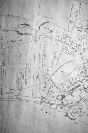
1834–35 Lithograph 24 x 38 in. Gloucester City Archives
"Drawn on a scale of one hundred feet to an inch. By John Mason 1834–45 from Actual Survey showing every Lott and building then standing on them giving the actual size of the buildings and width of the streets from the Canal to the head of the Harbour & part of Eastern point as farr as Smith's Cove and the Shore of the same with all the wharfs then in use. Gloucester Harbor 1834–1835."
This section of the map shows the location of the Pavilion Hotel and ropewalk along the beach.
Also filed under: Maps » // Mason, John » // Pavilion (Publick) Beach » // Pavilion Hotel » // Ropewalk »
44 x 34 in.
John Hanson, Publisher
Cape Ann Museum Library & Archive
"Map of the Towns of Gloucester and Rockport, Massachusetts. H.F. Walling, Civil Engineer. John Hanson, Publisher. 1851. Population of Gloucester in 1850 7,805. Population of Rockport in 1850 3,213."
Also filed under: Fort (The) and Fort Point » // Low (Frederick G.) wharves » // Maps » // Rogers's (George H.) wharves » // Town / Public Landings » // Waterfront, Gloucester »
Eastern Point is the long promontory that defines the eastern limit of Gloucester Harbor. In Lane's day it was wild and uninhabited but was also a strategic landmark. A Civil War fort was built there in 1863. Lane painted his seminal series of Brace's Cove and Brace's Rock from a vantage point on the eastern side.
The area was made safer for navigation by the construction of a new lighthouse in 1831 and the breakwater known as the Dog Bar. First proposed in 1866 in order to reduce turbulence in the waters of the outer harbor during heavy weather, it was not until 1894 that work on its construction began. Progress was slow, and although an extraordinary number of shipwrecks and groundings in 1898 sped it up somewhat, the breakwater was not completed until 1905.
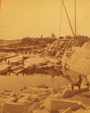
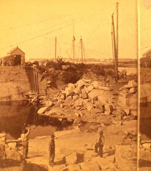
c.1880 Stereograph card Cape Ann Museum Library & Archive
This view shows a wood derrick for hoisting granite blocks.
Also filed under: Granite Quarrying / Shipping » // Historic Photographs »
Glass plate negative from Benham Collection
Cape Ann Museum Library & Archive
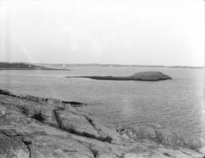
View of Gloucester Harbor from Friend Street Wharves, Five Pound Island segment at far left, Rocky Neck, Eastern Point and Ten Pound Island in background.
Also filed under: Five Pound Island » // Gloucester – City Views »

Engraving of 1819 survey taken from American Coast Pilot 14th edition
9 1/2 x 8 in.
Cape Ann Museum Library & Archive
D32 FF5
Also filed under: Dolliver's Neck » // Maps » // Norman's Woe » // Ten Pound Island »

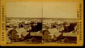
c.1870 Stereograph card Procter Brothers, Publisher Cape Ann Museum Library & Archive
View from Civil War fort on Eastern Point.
Also filed under: Gloucester Harbor, Outer » // Historic Photographs »
c.1880 Stereograph card Cape Ann Museum Library & Archive
This view shows a wood derrick for hoisting granite blocks.
Also filed under: Granite Quarrying / Shipping » // Historic Photographs »
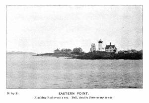
Plate from The Illustrated Coast Pilot with Sailing Directions: The Coast of New England from New York to Eastport, Maine including Bays and Harbors, published by N. L. Stebbins,1896.
Also filed under: Gloucester, Mass. – Eastern Point Light »
Stereograph card
Published by Frank Rowell
Cape Ann Museum Library & Archive
Also filed under: Gloucester, Mass. – Eastern Point Light »

John Heywood Photo for Hervey Friend
Cape Ann Museum Library & Archive (2013.068)
Schooners anchored on the Pancake Ground, taken from from Wonson's Cove, easterly side of the Rocky Neck causeway. Eastern Point Fort and garrison in background to far left.
Also filed under: Gloucester Harbor, Outer »
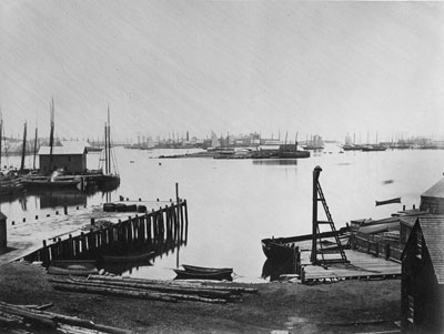
The northeast quarter of Gloucester Harbor is an inlet bounded by Fort Point and Rocky Neck at its entrance. It is further indented by three coves: Harbor Cove and Vincent’s Cove on its north side, and Smith’s Cove on its south side. The shallow northeast end is called Head of the Harbor. Collectively, this inlet with its coves and shallows is called Inner Harbor.
The entrance to Inner Harbor is a wide channel bounded by Fort Point and Duncan’s Point on its north side, and by Rocky Neck on its south side. From colonial times to the late nineteenth century, it was popularly known as “the Stream” and served as anchorage for deeply loaded vessels for “lightering” (partial off-loading). Subsequently it was known as “Deep Hole.”
Of Inner Harbor’s three coves, Harbor Cove (sometimes called “Old Harbor” in later years) was the deepest and most heavily used by fishing vessels in the Colonial Period, and largely dominated by the foreign trade in the first half of the nineteenth century. Its shallow bottom was the undoing of the foreign trade, as larger vessels became too deep to approach its wharves, and the cove returned to servicing a growing fishing fleet in the 1850s.
Vincent’s Cove, a smaller neighbor to Harbor Cove, was bare ground at low tide, and mostly useless for wharfage. Its shoreline was well suited for shipbuilding, and the cove was deep enough at high tide for launching. Records of shipbuilding there prior to the early 1860s have to date not been found.Smith’s Cove afforded wharfage for fishing vessels at its east entrance, as seen in Lane’s lithograph View of the Town of Gloucester, Mass., 1836 (inv. 86). The rest of the cove saw little use until the expansion of the fisheries after 1865.
The Head of the Harbor begins at the shallows surrounding Five Pound Island, extending to the harbor’s northeast end. Lane’s depiction of this area in Gloucester Harbor, 1847 (inv. 23) shows the problems faced by vessel owners at low tide. Despite the absence of deep water, this area saw rapid development after 1865 when a thriving fishing industry needed waterfront facilities, even if they were accessible only at high tide.
– Erik Ronnberg

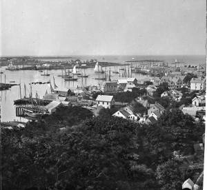
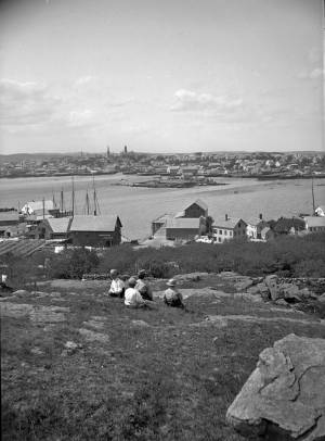
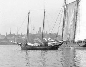
c.1870 Cape Ann Museum Library & Archive (2013.068)
Schooner fleet anchored in the inner harbor. Looking east from Rocky Neck, Duncan's Point wharves and Lane house (at far left), Sawyer School cupola on Friend Street.
Also filed under: Duncan's Point » // Historic Photographs » // Schooner (Fishing) » // Waterfront, Gloucester »
1876 Photograph Cape Ann Museum Library & Archive
Also filed under: Historic Photographs » // Schooner (Fishing) » // Waterfront, Gloucester »

1851 44 x 34 in. Henry Francis Walling, Map of the Towns of Gloucester and Rockport, Essex Co. Massachusetts. Philadelphia, A. Kollner, 1851 Cape Ann Museum Library & Archive
"Map of the Towns of Gloucester and Rockport, Massachusetts. H.F. Walling, Civil Engineer. John Hanson, Printer. 1851. Population of Gloucester in 1850 7,805. Population of Rockport in 1850 3,213."
Also filed under: Baptist Church (Old, First, 1830) (Pleasant Street) » // Burnham Brothers Marine Railway » // Duncan's Point » // Five Pound Island » // Flake Yard » // Harbor Methodist Church (Prospect Street) » // Low (Frederick G.) wharves » // Pavilion Hotel » // Procter Brothers » // Ropewalk » // Vincent's Cove » // Western Shore »

4 x 6 in.
Cape Ann Museum, Benham Collection
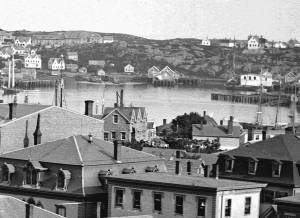
George Steele sail loft, William Jones spar yard, visible across harbor. Photograph is taken from high point on the Fort, overlooking business buildings on the Harbor Cove side.
Also filed under: Fort (The) and Fort Point » // Town House » // Universalist Church (Middle and Church Streets) » // Waterfront, Gloucester »


1834–35 Lithograph 24 x 38 in. Gloucester City Archives
"Drawn on a scale of one hundred feet to an inch. By John Mason 1834–45 from Actual Survey showing every Lott and building then standing on them giving the actual size of the buildings and width of the streets from the Canal to the head of the Harbour & part of Eastern point as farr as Smith's Cove and the Shore of the same with all the wharfs then in use. Gloucester Harbor 1834–35."
This map shows the location of F. E. Low's wharf and the ropewalk. Duncan's Point, the site where Lane would eventually build his studio, is also marked.
The later notes on the map are believed to be by Mason.
Also filed under: Duncan's Point » // Low (Frederick G.) wharves » // Low, Capt. Frederick Gilman » // Maps » // Mason, John » // Residences » // Ropewalk » // Somes, Capt. John »
44 x 34 in.
Henry Francis Walling, Map of the Towns of Gloucester and Rockport, Essex Co. Massachusetts. Philadelphia, A. Kollner, 1851
Cape Ann Museum Library & Archive
"Map of the Towns of Gloucester and Rockport, Massachusetts. H.F. Walling, Civil Engineer. John Hanson, Publisher. 1851. Population of Gloucester in 1850 7,805. Population of Rockport in 1850 3,213."
Segment of Harbor Village portion of map showing Collins' and other wharves in the Inner Harbor.
Also filed under: Graving Beach »

Collection of Erik Ronnberg
View related catalogue entries (2) »
Also filed under: Dolliver's Neck » // Fresh Water Cove » // Gloucester Harbor, Outer » // Maps »
1865 41 x 29 inches Courtesy of the Massachusetts Archives Maps and Plans, Third Series Maps, v.66:p.1, no. 2352, SC1/series 50X
.
Also filed under: Burnham Brothers Marine Railway » // Collins's, William (estate wharf) » // Maps » // Rogers's (George H.) wharves »
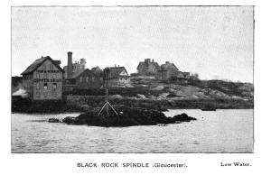
Photograph in The Illustrated Coast Pilot with Sailing Directions. The Coast of New England from New York to Eastport, Maine including Bays and Harbors, published by N. L. Stebbins, Boston
Also filed under: Beacons / Monuments / Spindles »
Stereograph card Cape Ann Museum Library & Archive
Also filed under: Gloucester – City Views » // Historic Photographs »
c.1870s Stereograph card Cape Ann Museum Library & Archive
From East Gloucester looking towards Gloucester.
Also filed under: Gloucester – City Views » // Historic Photographs »
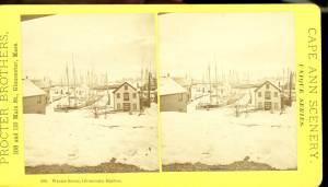
1876 Stereograph card Cape Ann Museum Library & Archive
Stereo view showing Gloucester Harbor after a heavy snowfall
Also filed under: Historic Photographs » // Waterfront, Gloucester »
Cape Ann Museum Library & Archive
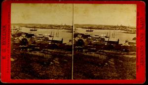
Five Pound Island and Gloucester inner harbor taken from the top of Hammond Street building signs in foreground are for Severance, Carpenter and Crane, and Cooper at Clay Cove.
Also filed under: Five Pound Island »
1852
Oil on canvas
28 x 48 1/2 in.
Cape Ann Museum, Gloucester, Mass., Deposited by the City of Gloucester, 1952. Given to the city by Mrs. Julian James in memory of her grandfather Sidney Mason, 1913 (DEP. 200)
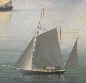
Detail of fishing schooner.
Also filed under: Schooner (Fishing) »
Oil on canvas
34 x 45 3/4 in.
Cape Ann Museum, Gloucester, Mass., Gift of Mrs. Jane Parker Stacy (Mrs. George O. Stacy),1948 (1289.1a)
Detail of party boat.
Also filed under: Party Boat »
c.1869 Glass plate negative Cape Ann Museum Library & Archive Detail from CAHA#00279
The magnificent views of Gloucester Harbor and the islands from the top floor of the stone house at Duncan's Point where Lane had his studio were the inspiration for many of his paintings.
From Buck and Dunlop, Fitz Henry Lane: Family, and Friends, pp. 59–74.
Also filed under: Duncan's Point » // Lane's Stone House, Duncan's Point » // Residences »
Glass plate negative
3 x 4 in.
Cape Ann Museum Library & Archive
#10112
Also filed under: Chebacco Boat / Dogbody / Pinky »
1876 Photograph Cape Ann Museum Library & Archive
Ignatius Weber's windmill (now defunct) is shown.
Also filed under: Flake Yard » // Fort (The) and Fort Point » // Historic Photographs » // Rogers's (George H.) wharves » // Schooner (Fishing) » // Waterfront, Gloucester » // Windmill »

1860 In John J. Babson, History of the Town Gloucester (Gloucester, MA: Procter Brothers, 1860) Cape Ann Museum Library & Archives, Gloucester, Mass.
See p. 474.
View related catalogue entries (4) »
Also filed under: Babson History of the Town of Gloucester » // Chebacco Boat / Dogbody / Pinky » // Fort (The) and Fort Point » // Gloucester, Mass. - "Ten Pound Island Light » // Schooner (Coasting / Lumber / Topsail / Packet / Marsh Hay) » // Ten Pound Island »
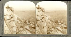
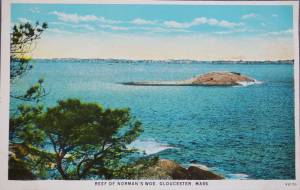
Norman’s Woe is a large rock sitting a few hundred feet off the western shore of Gloucester harbor. It lies between Gloucester and Magnolia and is just outside the confines of the harbor, if Eastern Point is used as the defining southern extent of the protected water. It can be reached from the shore at low tide over the rocks and is an island at high tide.
Tradition has it that a man named Norman was shipwrecked and lost there, but there is no historical record to substantiate it. Henry Wadsworth Longfellow memorialized it in his famous poem "The Wreck of the Hesperus" in 1840 though he never laid eyes on the rock until many years after he wrecked the Hesperus on it. His inspiration may have come from the wreck of the ship "Favorite" from Wiscasset, Maine on Norman’s Woe during the great blizzard of 1839. All hands were lost, one of whom was a woman who was found dead still tied to the mast which had floated ashore.
Because it lies outside the protection of the easterly arm of Eastern Point, Norman’s Woe and the surrounding rocky coast take the brunt of huge waves rolling in from the open ocean to the east, particularly after a storm. The high hills behind that western shore act as a wind block while tide and waves push a craft shoreward making Norman’s Woe the site of numerous shipwrecks and much loss of life through the years.
Lane did a drawing and some number of paintings of the site. He drew the rock from the shore looking to the south. Instead of the violent seas for which that shore is known he depicted it in a glassy calm. One of his landmark late paintings The Western Shore with Norman's Woe, 1862 (inv. 18) shows a boat drifting idly in the still late afternoon light in the cove just to the north of the rock of Norman’s Woe.
c.1860 Stereograph card Cape Ann Museum Library & Archive
Stereo View: "Geography – Norman's Woe is a headland on the mainland of Massachusetts just south of Gloucester Harbor, which is directly before us here. That very small island, to the left of the cliff, is called Norman's Woe Rock. Both places are so named because of the shipwreck of some member of the Norman family,who were among the early settlers in this locality.
Geology – The irregular jointing shows very clearly along the face of this cliff, where the action of the wind and weathering have cleared away the loose particles between the joints. The reason these rocks have withstood the destructive action of the erosion and weathering is because they are formed cheifly of felspar; in fact, this is a dike of that material.
Literature - Longfellow's poem, "The Wreck of the Hesperus," has immortalized the traditions that centre about these shores. The pounding of the waves uon this rock-bound promontory, and the dismal howling of the wind at this point, furnished him with the inspiration needed for his most favored masterpiece.
People and Homes - Seated upon our left is a very typical New England gentlemen, a real "down east Yankee." He exhibits all the qualities that made his ancestors so staunch in their determination to defend their adopted land."
Also filed under: Historic Photographs »

44 x 34 in.
Henry Francis Walling, Map of the Towns of Gloucester and Rockport, Essex Co. Massachusetts. Philadelphia, A. Kollner, 1851
Cape Ann Museum Library & Archive
"Map of the Towns of Gloucester and Rockport, Massachusetts. H.F. Walling, Civil Engineer. John Hanson, Publisher. 1851. Population of Gloucester in 1850: 7,805. Population of Rockport in 1850: 3,213."
Also filed under: Annisquam River » // Brookbank » // Dolliver's Neck » // Fresh Water Cove » // Gloucester Harbor, Outer » // Maps » // Stage Rocks / Stage Fort / Stage Head » // Steepbank » // West Gloucester – Little River » // Western Shore »
Engraving of 1819 survey taken from American Coast Pilot 14th edition
9 1/2 x 8 in.
Cape Ann Museum Library & Archive
D32 FF5
Also filed under: Dolliver's Neck » // Eastern Point » // Maps » // Ten Pound Island »
Newspaper
Gloucester Telegraph
In this article, a moonlight view of the harbor of Cape Ann by Lane is described in detail by a viewer and his skill in depicting the Cape Ann coastline is praised. Lane's associates, Salmon and Birch, are mentioned, but as comparisons to Lane. "Those who visited his room, were highly pleased with the skill he manifested in portraying the beauties of our coast."
Also filed under: Newspaper / Journal Articles » // Salmon, Robert » // Studio Descriptions »
Newspaper
"Mr. Lane has just completed a third picture of the Western Shore of Gloucester Harbor, including the distance from 'Norman's Woe Rock' to 'Half Moon Beach.' It was painted for Mr. William E. Coffin of Boston, and will be on exhibition at the artist's rooms for only a few days; we advise all our readers who admire works of art, and would see one of the best pictures Mr. Lane has ever executed..."
"...solitary pine, so many years a familiar object and landmark to the fisherman."
Newspaper clipping
Cape Ann Advertiser
Cape Ann Museum Library & Archive
"F.H. Lane, Esq., has recently finished a splendid painting of Norman's Woe, and scenery in the vicinity. It is a sunset scene, and gorgeous to the extreme."
Also filed under: Newspaper / Journal Articles »
A Narrative poem based on the Blizzard of 1839 off Norman's Woe of Gloucester, in which many ships sank and many lives lost, including that of a woman whose body washed up on shore, still tied to a mast. There was also a real vessel "Hesperus" which wrecked off of Boston.
The Wreck of the Hesperus
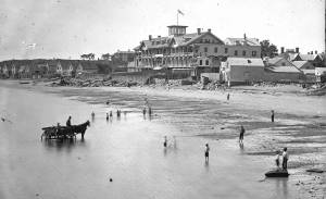
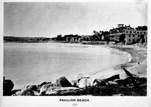
Pavilion Beach is an approximately 1/5 mile long sandy beach that runs along the south side of Commercial Street from Fort Square to the public landing at the easterly end of Western Avenue. The beach faces out over Gloucester Harbor.
Pavilion Beach has long played an important role in the history of Gloucester’s Harbor Village. During Colonial times, the sandy beach was recognized as a crucial barrier between the potentially turbulent waters of Gloucester’s Outer Harbor and the tranquility of Harbor Cove, an inlet which offered a safe area for the construction of wharves and the berthing of vessels. So important was the barrier that during the 1720s town officials awarded a handful of respected merchants a land grant encompassing 80 feet of uplands with the proviso that they promptly build a wharf and maintain it in order to prevent the sea from washing over. During the 1730s, as maritime based commerce slowly took hold around Gloucester Harbor, additional grants were made designed to increase investment in the land and encourage its responsible use. Historian John J. Babson noted that at that same time (c.1730) a group of citizens was enlisted to form a committee… to repair the beach, that the sea might not break over it ‘& spoyl the harbour…” In 1742, funds were appropriated by the General Court of the Commonwealth for the construction of a fortification at the seaward end of Pavilion Beach. The citizens of Gloucester had been asking for protection from possible attacks by sea since the early 1700s. Once commitments were made to the project, the preservation of Pavilion Beach became even more crucial.
For many of Fitz Henry Lane’s generation, here on Cape Ann and afar, Pavilion Beach was synonymous with sightings of the famous Gloucester sea serpent. Reports of a serpent frolicking in Gloucester Harbor were first made in August 1817. So credible were the reports that testimony was formally gathered under oath by the New England Linnaean Society and published in a small tract. The serpent returned in subsequent years generating a flood of publicity which helped jump start Cape Ann’s early summer tourist business in the decades leading up to the Civil War.
– Martha Oaks (April, 2015)
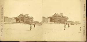
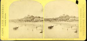
Stereograph card
Cape Ann Museum Library & Archive
Pavilion Hotel and the beach looking west from the Fort, Beach Court and Western Avenue.
Also filed under: Pavilion Hotel »

24 x 38 in.
Gloucester City Archives
"Drawn on a scale of one hundred feet to an inch. By John Mason 1834–45 from Actual Survey showing every Lott and building then standing on them giving the actual size of the buildings and width of the streets from the Canal to the head of the Harbour & part of Eastern point as farr as Smith's Cove and the Shore of the same with all the wharfs then in use. Gloucester Harbor 1834–35."
This map is especially useful in showing the Fort.
Also filed under: Flake Yard » // Fort (The) and Fort Point » // Maps » // Mason, John » // Town / Public Landings »
c.1870s Stereograph card Cape Ann Museum Library & Archive
Also filed under: Historic Photographs » // Pavilion Hotel »
1834–35 Lithograph 24 x 38 in. Gloucester City Archives
"Drawn on a scale of one hundred feet to an inch. By John Mason 1834–45 from Actual Survey showing every Lott and building then standing on them giving the actual size of the buildings and width of the streets from the Canal to the head of the Harbour & part of Eastern point as farr as Smith's Cove and the Shore of the same with all the wharfs then in use. Gloucester Harbor 1834–1835."
This section of the map shows the location of the Pavilion Hotel and ropewalk along the beach.
Also filed under: Maps » // Mason, John » // Pavilion Hotel » // Ropewalk » // Windmill »
1834–35 24 x 38 in. Gloucester City Archives
"Drawn on a scale of one hundred feet to an inch. By John Mason 1834–45 from Actual Survey showing every Lott and building then standing on them giving the actual size of the buildings and width of the streets from the Canal to the head of the Harbour & part of Eastern point as farr as Smith's Cove and the Shore of the same with all the wharfs then in use. Gloucester Harbor 1834–35."
This map is especially helpful in showing the wharves of the inner harbor at the foot of Washington Street.
Also filed under: Dale, Eben B. » // Eastern Railroad » // Flake Yard » // Gloucester Harbor, Inner / Harbor Cove » // Hough, Benjamin Kent » // Maps » // Ropewalk » // Sawyer, Samuel » // Town / Public Landings » // Universalist Church (Middle and Church Streets) »
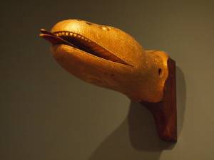
Carved wood with paint and gilt
12 x 22 x 8 in.
Cape Ann Museum. Gift of George W. Woodbury, 1936 (747)
This sea serpent billet head came from the schooner "Diadem" which was built in Essex, Massachusetts, in 1855 and owned by D. Elwell Woodbury and John H. Welsh of Gloucester.
Sea serpents were reportedly sighted here on Cape Ann from colonial times through the mid-nineteenth century. In 1817, more than 50 people, many of them prominent members of the community, reported seeing a serpent in the waters of Gloucester Harbor just off Pavilion Beach. So credible were the reports that the Linnaean Society of New England collected depositions from witnesses and published their findings in a small pamphlet entitled Report of a Committee of the Linnaean Society of New England relative to a Large Marine Animal Supposed to be A Serpent, seen Near Cape Ann, Massachusetts, in August 1817.
Also filed under: Objects » // Vessel Details: Decorations / Ship Carvings »
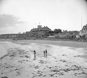
c.1870s Stereograph card Cape Ann Museum Library & Archive
Stereo view of the Pavilion from the southern or sea side.
Also filed under: Historic Photographs » // Pavilion Hotel »
c.1870s Stereograph card Cape Ann Museum Library & Archive
Also filed under: Historic Photographs » // Pavilion Hotel »
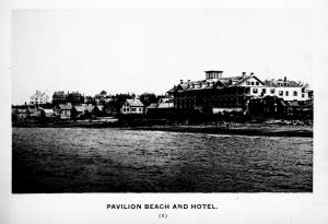
c.1870 Cape Ann Museum Library & Archive
Taken from Fort Point looking west. Ropewalk just to west of hotel.
Also filed under: Historic Photographs » // Pavilion Hotel » // Ropewalk »
c.1900.
Also filed under: Pavilion Hotel »
Ten Pound Island guards the entrance to Gloucester’s Inner Harbor and provides a crucial block to heavy seas running southerly down the Outer Harbor from the open ocean beyond. The rocky island and its welcoming lighthouse is seen, passed, and possibly blessed by every mariner entering the safety of Gloucester’s Inner Harbor after outrunning a storm at sea. Ten Pound Island is situated such that the Inner Harbor is protected from open water on all sides making it one of the safest harbors in all New England.
Legend has it that the island was named for the ten pound sum paid to the Indians for the island, and the smaller Five Pound Island deeper in the Inner Harbor was purchased for that lesser sum. None of it makes much financial sense when the entirety of Cape Ann was purchased for only seven pounds from the Indian Samuel English, grandson of Masshanomett the Sagamore of Agawam in 1700. From approximately 1640 on the island was used to hold rams, and anyone putting female sheep on the island was fined. Gloucester historian Joseph Garland has posited that the name actually came from the number of sheep pens it held, or pounds as they were called, and the smaller Five Pound Island was similarly named.
The island itself is only a few acres of rock and struggling vegetation but is central to the marine life of the harbor as it defines the eastern edge of the deep channel used to turn the corner and enter the Inner Harbor. The first lighthouse was lit there in 1821, and a house was built for the keeper adjacent to the lighthouse.
In the summer of 1880 Winslow Homer boarded with the lighthouse keeper and painted some of his most masterful and evocative watercolor views of the busy harbor life swirling about the island at all times of day. Boys rowing dories, schooners tacking in and out in all weather, pleasure craft drifting in becalmed water, seen together they tell a Gloucester story of light, water and sail much as Lane’s work did only several decades earlier.

Colored lithograph
Cape Ann Museum Library and Archive
Also filed under: Gloucester, Mass. - "Ten Pound Island Light »

Photograph
From The Illustrated Coast Pilot with Sailing Directions. The Coast of New England from New York to Eastport, Maine including Bays and Harbors, N. L. Stebbins, 1891.
Also filed under: Gloucester, Mass. - "Ten Pound Island Light »


Oil on canvas
22 x 36 in.
Cape Ann Museum, Gloucester, Mass., deposited by the Collection of Addison Gilbert Hospital, 1978 (DEP. 201)
Detail of party boat.
Also filed under: Party Boat »
Engraving of 1819 survey taken from American Coast Pilot 14th edition
9 1/2 x 8 in.
Cape Ann Museum Library & Archive
D32 FF5
Also filed under: Dolliver's Neck » // Eastern Point » // Maps » // Norman's Woe »
Newspaper
Gloucester Telegraph
"By the will of the late Fitz H. Lane, Esq., his handsome painting of the Old Fort, Ten Pound Island, etc., now on exhibition at the rooms of the Gloucester Maritime Insurance Co., was given to the town... It will occupy its present position until the town has a suitable place to receive it."

Stereograph card
Cape Ann Museum Library & Archive
View from top of Unitarian Church on Middle Street looking southeast, showing the Fort and Ten Pound Island. Tappan Block and Main Street buildings between Center and Hancock in foreground.
Also filed under: Fort (The) and Fort Point » // Unitarian Church / First Parish Church (Middle Street) »
1860 In John J. Babson, History of the Town Gloucester (Gloucester, MA: Procter Brothers, 1860) Cape Ann Museum Library & Archives, Gloucester, Mass.
See p. 474.
View related catalogue entries (4) »
Also filed under: Babson History of the Town of Gloucester » // Chebacco Boat / Dogbody / Pinky » // Fort (The) and Fort Point » // Gloucester Harbor, Inner / Harbor Cove » // Gloucester, Mass. - "Ten Pound Island Light » // Schooner (Coasting / Lumber / Topsail / Packet / Marsh Hay) »
The Ten Pound Island light was built on a three-and-a-half acre island at the eastern end of Gloucester Harbor. Built as a conical stone tower, the original 20-foot-tall Ten Pound Island Light was first lit in October, 1821 after the Commonwealth of Massachusetts and the Town of Gloucester ceded 1.7 acres to the U.S. Government for the construction of an inner harbor lighthouse to help mariners navigate the harbor. Ten Pound Island light was a popular subject with artists, including Winslow Homer, who boarded with the lighthouse keeper at Ten Pound Island in the summer of 1880. It is frequently featured in Lane's paintings of Gloucester Harbor.
This information has been shared with the Lane project by Jeremy D'Entremont. More information can be found at his website, www.newenglandlighthouses.net or in The Lighthouse Handbook New England. This information has also been summarized from Paul St. Germain's book, Lighthouses and Lifesaving Stations on Cape Ann.

Colored lithograph
Cape Ann Museum Library and Archive
Also filed under: Ten Pound Island »
Photograph
From The Illustrated Coast Pilot with Sailing Directions. The Coast of New England from New York to Eastport, Maine including Bays and Harbors, N. L. Stebbins, 1891.
Also filed under: Ten Pound Island »

The terms "cob wharf" and "crib wharf" refer to a common form of wharf construction dating from pre-colonial times in Europe to the early nineteenth century in America. Both utilize a rectangular frame of timber called a "crib," which forms the foundation of the timber-and-fill structure built over it.The Hamersly Naval Encyclopaedia defines a crib as "a structure of logs filled with stones, etc., and used as a dam, pier, ice-breaker, etc." A cob is defined as "a breakwater or dock made of piles and timber, and filled in with rocks. The vagueness of these definitions probably explains the interchange of these terms in contemporary descriptions. (1)
In Lane's paintings of Gloucester Harbor, we see what could be both examples of these wharf types on the point of land in Gloucester Harbor, 1847 (inv. 23) at far left. The wharf built up of layers of cribs (like a log cabin) fits the definition of a crib wharf, while the wharf beyond it with vertical pilings enclosing exposed stone would be a cob wharf. Going by this observation, other examples of cob wharves can be found in the depictions of Harbor Cove from the 1840s in The Old Fort and Ten Pound Island, Gloucester, 1850s (inv. 28), The Old Fort and Ten Pound Island, Gloucester, 1850s (inv. 30), and The Fort and Ten Pound Island, Gloucester, Massachusetts, 1847 (inv. 271).
Going by the Hamersly definition of cob wharf, coupled with recent archeological studies of Boston's old waterfront, this constuction was used for both finger piers and bulkhead piers in Gloucester Harbor. Thus, the bukhead piers adjoining and linking the wharves on Fort Point were cob wharves, their stone fill appearing no different from that of the finger piers. (2)
The stone fill used in these wharves was rubble stone: beach stones, field stones, and boulders broken into irregular shapes. Shaped stone blocks of quarried granite do not appear in Lane's depictions of wharves until George H. Rogers began construction of his wharf on Fort Point as noted in Ten Pound Island, Gloucester, 1850s (inv. 17) and Ten Pound Island in Gloucester Harbor, 1864 (inv. 104). The building of this wharf marks a clean break with older wharf construction in Gloucester's Harbor Cove.
– Erik Ronnberg
References::
1. A Naval Encyclopaedia (Philadelphia: L. R. Hamersly & Co., 1884. Reprint: Detroit: Gale Research Co., 1971), 146,182.
2. Nancy S. Seasholes, Breaking Ground: A History of Landmaking in Boston (Cambridge, MA: The MIT Press, 2003), 13–19.
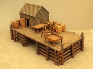
Wood, metal, and paint
20 1/4 x 10 1/4 x 10 1/2 in., scale: 1/2" = 1'
Made for the Columbian Exposition, Chicago, 1892–93
Cape Ann Museum, from Gloucester Chamber of Commerce
The wharf is built up of "cribs", square (sometimes rectangular) frames of logs, resembling a log cabin, but with spaces between crib layers that allow water to flow freely through the structure.Beams are laid over the top crib, on which the "deck" of the wharf is built. Vertical pilings (or "spiles" as locally known) are driven at intervals to serve as fenders where vessels are tied up.
– Erik Ronnberg
Also filed under: Waterfront, Gloucester »
Marks: Inscribed upper left (in red ink): 67 [numbering system used by curator A. M. Brooks upon Samuel H. Mansfield's donation of the drawings to the Cape Ann Museum]