An online project under the direction of the CAPE ANN MUSEUM
Catalogue Entry
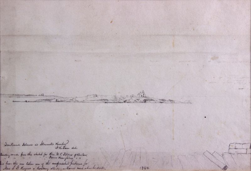
This drawing of Ten Pound Island from George Rogers's wharf was the basis for Ten Pound Island, Gloucester, 1850s (inv. 17). As with several of Lane's drawings, posthumous inscriptions indicate that he used the drawing for several different paintings. James Craig has pointed out that the three people named on this drawing were all from the Boston area, indicating that Lane was serving the tourist industry. (1)
Typically Lane made detailed drawings of the landscape features, and then added vessels as he composed the painting. Traditionally, the painting related to this drawing has received a date of mid-1850s. However, the wharf under construction now is believed to be one that is known to first appear on maps in 1865. (2)
The drawing shows the lighthouses of Ten Pound Island and Eastern Point, and also, in the foreground, the stone and wood pilings being used in the construction of Rogers' swharf. Early in the nineteenth century, oak trees on the end of Eastern Point were used as navigational landmarks. It is hard to decipher whether the pencil marks on Eastern Point represent these trees or the buildings of the lighthouse.
– Erik Ronnberg
References:
1. James A. Craig, “Fitz H. Lane”(Charleston, SC: History Press, 2006), 91.
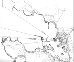
2. Consultation of a Harbor Commissioner’s chart of Gloucester, dated 1865, shows Rogers’ two finger piers on the southeast side of Fort Point (see chart and details) and a likelier viewing point for Lane’s drawing and derivative painting. Both wharves extend as angles to the shore and both were stone piers, probably topped with wooden decks when finished, hence the lumber on the wharf at center. When a line is drawn from the western end of Eastern Point, through the eastern third of Ten Pound Island, it touches the mid-point of Fort Point’s southeast shoreline (the Rogers wharves included). This is borne out in Lane’s painting, with some minor moving and modification of the wharves.
- Subject Types
: - Cape Ann Locales
: - Building Types
:
Historical Materials
Ten Pound Island guards the entrance to Gloucester’s Inner Harbor and provides a crucial block to heavy seas running southerly down the Outer Harbor from the open ocean beyond. The rocky island and its welcoming lighthouse is seen, passed, and possibly blessed by every mariner entering the safety of Gloucester’s Inner Harbor after outrunning a storm at sea. Ten Pound Island is situated such that the Inner Harbor is protected from open water on all sides making it one of the safest harbors in all New England.
Legend has it that the island was named for the ten pound sum paid to the Indians for the island, and the smaller Five Pound Island deeper in the Inner Harbor was purchased for that lesser sum. None of it makes much financial sense when the entirety of Cape Ann was purchased for only seven pounds from the Indian Samuel English, grandson of Masshanomett the Sagamore of Agawam in 1700. From approximately 1640 on the island was used to hold rams, and anyone putting female sheep on the island was fined. Gloucester historian Joseph Garland has posited that the name actually came from the number of sheep pens it held, or pounds as they were called, and the smaller Five Pound Island was similarly named.
The island itself is only a few acres of rock and struggling vegetation but is central to the marine life of the harbor as it defines the eastern edge of the deep channel used to turn the corner and enter the Inner Harbor. The first lighthouse was lit there in 1821, and a house was built for the keeper adjacent to the lighthouse.
In the summer of 1880 Winslow Homer boarded with the lighthouse keeper and painted some of his most masterful and evocative watercolor views of the busy harbor life swirling about the island at all times of day. Boys rowing dories, schooners tacking in and out in all weather, pleasure craft drifting in becalmed water, seen together they tell a Gloucester story of light, water and sail much as Lane’s work did only several decades earlier.

Colored lithograph
Cape Ann Museum Library and Archive
Also filed under: Gloucester, Mass. - "Ten Pound Island Light »

Photograph
From The Illustrated Coast Pilot with Sailing Directions. The Coast of New England from New York to Eastport, Maine including Bays and Harbors, N. L. Stebbins, 1891.
Also filed under: Gloucester, Mass. - "Ten Pound Island Light »


Oil on canvas
22 x 36 in.
Cape Ann Museum, Gloucester, Mass., deposited by the Collection of Addison Gilbert Hospital, 1978 (DEP. 201)
Detail of party boat.
Also filed under: Party Boat »

Engraving of 1819 survey taken from American Coast Pilot 14th edition
9 1/2 x 8 in.
Cape Ann Museum Library & Archive
D32 FF5
Also filed under: Dolliver's Neck » // Eastern Point » // Maps » // Norman's Woe »
Newspaper
Gloucester Telegraph
"By the will of the late Fitz H. Lane, Esq., his handsome painting of the Old Fort, Ten Pound Island, etc., now on exhibition at the rooms of the Gloucester Maritime Insurance Co., was given to the town... It will occupy its present position until the town has a suitable place to receive it."

Stereograph card
Cape Ann Museum Library & Archive
View from top of Unitarian Church on Middle Street looking southeast, showing the Fort and Ten Pound Island. Tappan Block and Main Street buildings between Center and Hancock in foreground.
Also filed under: Fort (The) and Fort Point » // Unitarian Church / First Parish Church (Middle Street) »

1860 In John J. Babson, History of the Town Gloucester (Gloucester, MA: Procter Brothers, 1860) Cape Ann Museum Library & Archives, Gloucester, Mass.
See p. 474.
View related catalogue entries (4) »
Also filed under: Babson History of the Town of Gloucester » // Chebacco Boat / Dogbody / Pinky » // Fort (The) and Fort Point » // Gloucester Harbor, Inner / Harbor Cove » // Gloucester, Mass. - "Ten Pound Island Light » // Schooner (Coasting / Lumber / Topsail / Packet / Marsh Hay) »
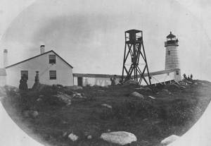
The Ten Pound Island light was built on a three-and-a-half acre island at the eastern end of Gloucester Harbor. Built as a conical stone tower, the original 20-foot-tall Ten Pound Island Light was first lit in October, 1821 after the Commonwealth of Massachusetts and the Town of Gloucester ceded 1.7 acres to the U.S. Government for the construction of an inner harbor lighthouse to help mariners navigate the harbor. Ten Pound Island light was a popular subject with artists, including Winslow Homer, who boarded with the lighthouse keeper at Ten Pound Island in the summer of 1880. It is frequently featured in Lane's paintings of Gloucester Harbor.
This information has been shared with the Lane project by Jeremy D'Entremont. More information can be found at his website, www.newenglandlighthouses.net or in The Lighthouse Handbook New England. This information has also been summarized from Paul St. Germain's book, Lighthouses and Lifesaving Stations on Cape Ann.


Colored lithograph
Cape Ann Museum Library and Archive
Also filed under: Ten Pound Island »
Photograph
From The Illustrated Coast Pilot with Sailing Directions. The Coast of New England from New York to Eastport, Maine including Bays and Harbors, N. L. Stebbins, 1891.
Also filed under: Ten Pound Island »

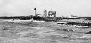
The Eastern Point Light is located in the town of Gloucester, Massachusetts on the east side of the entrance to Gloucester Harbor. In 1829, an unlit stone beacon was erected on Eastern Point to help mariners navigating Gloucester Harbor. Shortly thereafter, in 1832, a wrought-iron and copper lantern was added to the stone tower, and the first Eastern Point Light was born. During the 1840s, Gloucester became one of the most important fishing ports in America, and to cope with the increased fishing traffic, a new Eastern Point Light was built in 1848. The new 34 foot tower gained the nickname "The Ruby Light" due to its unique fixed red light. The Eastern Point Light was further improved upon in the following decades with the addition of a fourth-order Fresnel lens and fog bell.
This information has been shared with the Lane project by Jeremy D'Entremont. More information can be found at his website, www.newenglandlighthouses.net or in The Lighthouse Handbook New England. This information has also been summarized from Paul St. Germain's book, Lighthouses and Lifesaving Stations on Cape Ann.
Photograph U.S. Coastguard
For over 100 years the fishermen of Gloucester have been guided back to their home port by a lighthouse on Eastern Point. The present brick tower, painted a gleaming white, and standing on the long rocky point forming the eastern side of the harbor, was built in 1890, replacing on the same foundation the original tower built in 1832. Before 1832 a still older lighthouse, on Ten-Pound Island well inside of the harbor, had served as an entrance light, but this light was never visible until ships had actually found the entrance, hence the building of a lighthouse on the Eastern Point where it could be seen from far offshore.
Courtesy United States Coast Guard.
Also filed under: Historic Photographs »
Newspaper
"There are quite a number of visitors in town at the present time, who come to spend a few weeks by the seaside, during the sultry weather of August."
Also filed under: Fessenden, C. B. » // Newspaper / Journal Articles » // Procter Brothers – Gloucester, Mass. » // Tourist Industry »
Newspaper clipping
Cape Ann Advertiser
Collection of Fred and Stephanie Buck
"MARINE PAINTING. – F. H. Lane, Esq., has recently completed a picture for Dr. H. E. Davidson of this town. The painting represents a sunset scene in our harbor, which is taken near the cut bridge, introducing the beach covered with rocks and pebbles, steep bank, and Stage Fort, with the surrounding scenery in the vicinity. . . It is impossible to give an adequate idea of this painting by any description of ours, for it must be seen to be appreciated. It is the largest painting the artist has yet finished, and, in our opinion, his best. The painting is now on exhibition at the Studio, for a short time, where those who are interested in works of art can have an opportunity of viewing it."
Also filed under: Davidson, Dr. Herman Elvas » // Newspaper / Journal Articles » // Studio Descriptions »
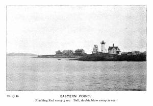
Plate from The Illustrated Coast Pilot with Sailing Directions: The Coast of New England from New York to Eastport, Maine including Bays and Harbors, published by N. L. Stebbins,1896.
Also filed under: Eastern Point »
Stereograph card
Published by Frank Rowell
Cape Ann Museum Library & Archive
Also filed under: Eastern Point »
Four circular glass prism lenses in a brass frame:
Lens diameters 19". Base 21" square x 19-1/2" high.
Cape Ann Museum. On permanent loan from the United States Coast Guard, 2013
When installed, the light source was fixed and the lens mount rotated.
Also filed under: Objects »
Lane made several paintings for James Haughton from drawings. Between 1844 and 1865, Haughton and Mr. Sawyer ran a dry goods store in Winthrop Square, Boston, as Haughton, Sawyer & Co. They advertised themselves as being Army and Navy Outfitters, offering knapsacks, horse blankets, and uniforms, and as specialists in India Rubber Goods. The shop was totally destroyed in the Great Fire of 1872, along with several thousand dollars worth of art Mr. Sawyer had brought back from Italy. Mr. Haughton was referred to by one historian (writing about Groton, Eliza Haughton’s home town) as “one of the most charming men I have ever met."
Samuel Sawyer Papers
Cape Ann Museum Library & Archives
Archive Collection exp015
"June 6. 2 Dutch coast scenes & frames. Fremart(?) (One Haughton)"
Also filed under: Diaries / Ledgers / Etc. » // Sawyer, Samuel »
Samuel Sawyer Papers
Cape Ann Museum Library & Archives
Archive Collection
"February 4. Went to the artists reception this evening. There was a large company. Haven (?) Fields Whipple & Co. We enjoyed the occasion very much. Our invitation came from Mr. Scott, Mr. Bartlett & Lottie also went, Mrs. Haughton did not."
Also filed under: Diaries / Ledgers / Etc. » // Sawyer, Samuel » // Scott, John W. A. »
"November 23. Cool & pleasant. Went to Gloucester.
Size of Haughton's pictures 2. 18 x 30 & 1. 10 x 15. [Lane?]"
Also filed under: Diaries / Ledgers / Etc. » // Sawyer, Samuel »
Samuel Sawyer Papers
Cape Ann Museum Library & Archives
Archive Collection
"August 15. Mr. & Mrs. H.(Haughton) staid over, went to sail in the morning & to ride in the afternoon. H. ordered 3 paintings of Mr. Lane for $150, 2 size about 18 x 30, & 1 small."
Also filed under: Diaries / Ledgers / Etc. » // Sawyer, Samuel »
Samuel Sawyer Papers
Cape Ann Museum Library & Archives
Archive Collection
"August 25. Called to see Mr. Lane to make a sketch of old Homestead for Haughtons."
Also filed under: Brookbank » // Diaries / Ledgers / Etc. » // Sawyer, Samuel »
Samuel Sawyer Papers
Cape Ann Museum Library & Archives
Archive Collection
"Mr. [F.H. Lane - crossed out] Lane came over to draw the outline for picture for Haughton"
Also filed under: Diaries / Ledgers / Etc. » // Sawyer, Samuel »
According to the inscription on Brace's Cove, Eastern Point, 1863 (inv. 147), Mrs. S. G. Rogers of Roxbury ordered a painting from "the entire sketch" by Lane. Brace's Rock, Eastern Point, 1863 (inv. 146) and Brace's Cove, Eastern Point, 1863 (inv. 147) were two halves of a single drawing, presumably separated by the time the inscription was written. Also according to that inscription, shortly before his death, Lane had prepared a canvas of 22 x 36 inches for the commission, but never completed the painting.
On another drawing Ten Pound Island in Gloucester Harbor, 1864 (inv. 104) was written: "And from this was taken one of the unfinished pictures for Mrs. S. G. Rogers of Roxbury standing in Lane's studio when he died," which suggests that Mrs. Rogers commissioned two paintings shortly before Lane's death.
An inscription on one of Lane's drawings of Ten Pound Island indicates that a painting was made after that drawing for the Reverend William Phillips Tilden. According to the inscription, Rev. Tilden was from Boston.
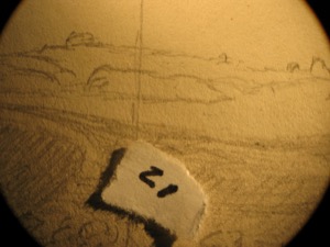
Marks: Inscribed upper left (in red ink): 2 [numbering system used by curator A. M. Brooks upon Samuel H. Mansfield's donation of the drawings to the Cape Ann Museum]