loading 
Fitz Henry Lane
HISTORICAL ARCHIVE • CATALOGUE RAISONNÉ • EDUCATIONAL RESOURCE
An online project under the direction of the CAPE ANN MUSEUM
An online project under the direction of the CAPE ANN MUSEUM
Catalog entry
inv. 104
Ten Pound Island in Gloucester Harbor
1864 Graphite on paper 10 5/8 x 14 7/8 in. (27 x 37.8 cm) Inscribed across bottom (in pencil): 1864 / Ten Pound Island in Gloucester Harbor / F.H.Lane del. / Painting made from this sketch for Rev. W.P. Tilden of Boston / " " " " " James Houghton / " " / And from this was taken one of the unfinished pictures for Mrs. S.G. Rogers of Roxbury standing in Lane's studio when he died.
|
Related Work in the Catalog
Supplementary Images
Provenance (Information known to date; research ongoing.)
the Artist, Gloucester, Mass.
Joseph L. Stevens, Jr., Gloucester, Mass.
Samuel H. Mansfield, Gloucester, Mass.
Cape Ann Museum, Gloucester, Mass., 1927
Marks & Labels
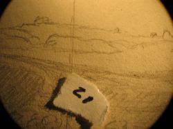
Marks: Inscribed upper left (in red ink): 2 [numbering system used by curator A. M. Brooks upon Samuel H. Mansfield's donation of the drawings to the Cape Ann Museum]
Exhibition History
Cape Ann Historical Association, Gloucester, Massachusetts, Training the Eye and Hand: Fitz Hugh Lane and Nineteenth Century American Drawing Books, September 17, 1993–January 29, 1994.
Published References
Paintings and Drawings by Fitz Hugh Lane. Gloucester, MA: Cape Ann Historical Association, 1974., fig. 12.
Craig, James. Fitz H. Lane: An Artist's Voyage through Nineteenth-Century America. Charleston, SC: The History Press, 2006., fig. 60, text, p. 91.


Commentary
This drawing of Ten Pound Island from George Rogers's wharf was the basis for Ten Pound Island, Gloucester, 1850s (inv. 17). As with several of Lane's drawings, posthumous inscriptions indicate that he used the drawing for several different paintings. James Craig has pointed out that the three people named on this drawing were all from the Boston area, indicating that Lane was serving the tourist industry.(1)
Typically Lane made detailed drawings of the landscape features, and then added vessels as he composed the painting. Traditionally, the painting related to this drawing has received a date of mid-1850s. However, the wharf under construction now is believed to be one that is known to first appear on maps in 1865.(2)
The drawing shows the lighthouses of Ten Pound Island and Eastern Point, and also, in the foreground, the stone and wood pilings being used in the construction of Rogers' swharf. Early in the nineteenth century, oak trees on the end of Eastern Point were used as navigational landmarks. It is hard to decipher whether the pencil marks on Eastern Point represent these trees or the buildings of the lighthouse.
– Erik Ronnberg
1. James A. Craig, “Fitz H. Lane”(Charleston, SC: History Press, 2006), 91.
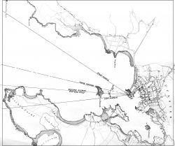
2. Consultation of a Harbor Commissioner’s chart of Gloucester, dated 1865, shows Rogers’ two finger piers on the southeast side of Fort Point (see chart and details) and a likelier viewing point for Lane’s drawing and derivative painting. Both wharves extend as angles to the shore and both were stone piers, probably topped with wooden decks when finished, hence the lumber on the wharf at center. When a line is drawn from the western end of Eastern Point, through the eastern third of Ten Pound Island, it touches the mid-point of Fort Point’s southeast shoreline (the Rogers wharves included). This is borne out in Lane’s painting, with some minor moving and modification of the wharves.