An online project under the direction of the CAPE ANN MUSEUM
Catalogue Entry
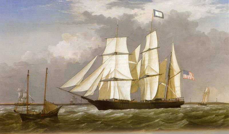
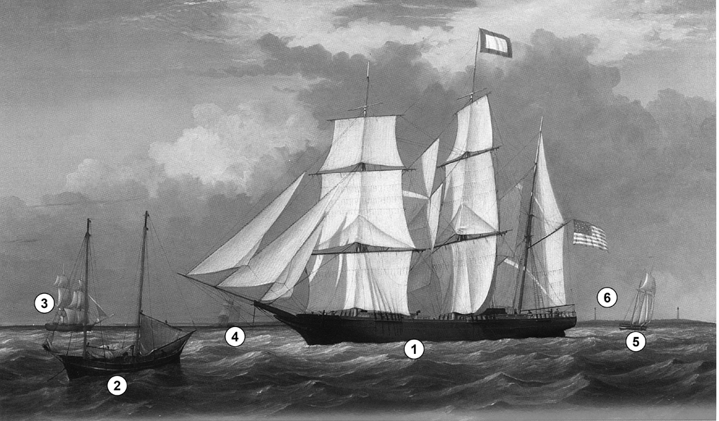
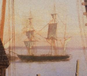
The bark “Eastern Star” (1) is homeward bound on the final leg to Boston. She may be shown as a new vessel, arriving from the north, having been fitted out in Maine where she was built. Three or four miles east of Cape Ann, she is coming about, the sails aback, as momentum will keep her turning while the yards are braced around to put her on a port tack. Sailing close-hauled, she may just reach Nahant before having to tack again. With any luck, she will take on a pilot at that time, tack briefly to the eastward, and enter Boston with the wind abeam.
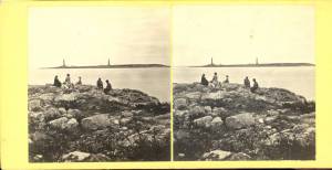
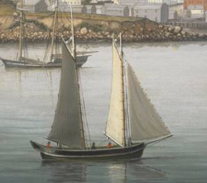
While tacking off Cape Ann, “Eastern Star” is in the company of a pinky (2, left foreground), whose crew is calling it a day, getting ready to raise sail, weigh anchor, and head for home. This vessel type, while outdated, proved so seaworthy and durable that many survived into the twentieth century. In the left background, a merchant brig (3) is on a broad reach to the north-east with her stu’ns’ls (studding sails) set. A half-brig (4) can be seen just below “Eastern Star’s” jib-boom, while a topsail schooner (5) on a close reach to the southeast is off her starboard quarter. To either side of the schooner, the twin lights of Thacher’s Island (6) may be seen.
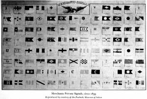
According to records, which are fragments and subject to correction, the bark “Eastern Star” was built at Robbinston, Maine in 1853; the builders have not been identified (Ref. 1). Her owners were Josiah Wheelwright and Samuel Crocker Cobb, Boston merchants whose partnership was formed in 1851 and dissolved in 1858 (Ref. 2). She is flying the blue-bordered house flag of her owners, as can be seen in the chart of house flags below.
–Erik Ronnberg
References:
1. John Robinson and George Francis Dow, “The Sailing Ships of New England, Series Two” (Salem, MA: Marine Research Society, 1924), Plate 370: Bark “Eastern Star of Boston, 378 tons, built at Robbinston, Maine, 1853. From an oil painting by F. H. Ta_____ (sic)”
2. (Web site) bostonhistory.org, Collection Number: MS0101, Diaries of Samuel Crocker Cobb, 1858 – 1874.
- Subject Types
: - Vessel Types
: - Cape Ann Locales
:
Historical Materials
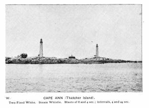
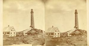
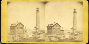
In 1635 Anthony Thacher and his wife were the only survivors from a shipwreck off the island. As compensation for the loss of his four children and cousins, the General Court gave the island to Thacher. The island became known as "Thacher's Woe" and remained in the family for 80 years. In 1771 the Province of Massachusetts Bay Council passed a bill for the erection of a lighthouse on Thacher Island and purchased the island from the heirs of Anthony Thacher. The name seems to have been Thacher's Island in the nineteenth century, although currently is known as Thacher Island.
The name of the island is variably spelled with and without a second "t."
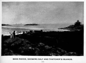
From Gloucester Picturesque, c.1900.
Also filed under: Salt Island »
Lithograph
28.5 x 21 in.
Cape Ann Museum Library & Archive
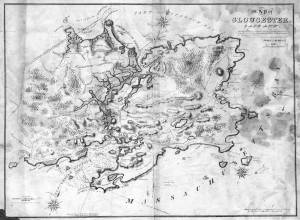
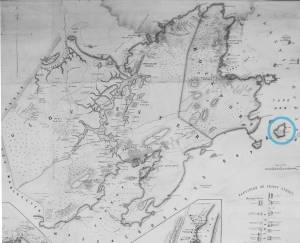
When Massachusetts decreed that each town be mapped, John Mason drew the map of Cape Ann in 1830. This drawing was sent to the Senefelder Lithographic Company of Boston (owned by William Pendleton) to be printed, and then sold in Gloucester by W.E.P. Rogers, whose Gloucester Telegraph of February 12, 1831 announced, "A few specimen copies of the map, uncolored, have reached the town" and that they cost $1.25. Perhaps this business arrangement between Pendleton and Rogers provided Lane with his introduction to Pendleton.
Also filed under: Folly Cove » // Good Harbor Beach / Bass Rocks » // Maps » // Mason, John » // Meetinghouse Green » // Pendleton's, Lith. – Boston » // Salt Island »
Newsprint
Cape Ann Advertiser
Collection of Fred and Stephanie Buck
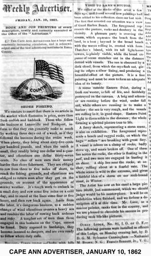
"VISIT TO LANE'S STUDIO.
We called at the studio of this artist a few days ago, and found several new paintings had been added to his collection since our last visit. The first that arrested our attention was a view of Good Harbor Beach. . . .
A scene outside Eastern Point, during a fresh sou'wester, is full of life, and faithfully portrayed on the canvass. . . .
A fancy sketch, representing a storm scene, is also on exhibition. . . .
The Artist has now on his easel a large picture 36x60, just commenced, which we should judge would be his master-piece. It will be on exhibition when finished, and we forbear a description of it at this time. Mr. Lane, as a marine painter, ranks first in the country, and we are pleased to chronicle his success in producing such life-like pictures."
Also filed under: Cod / Cod Fishing » // Fishing » // Newspaper / Journal Articles » // Rockport, Mass. - Thacher Island Twin Lighthouses » // Studio Descriptions »
Newspaper clipping
Cape Ann Advertiser
Collection of Fred and Stephanie Buck
About a visit to the new lighthouse:
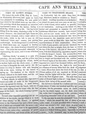
"VISIT TO THATCHER'S ISLAND.
On Wednesday last, the yacht Mary Bell, Capt. Merchant, made an excursion to Thatcher's Island. Availing ourselves of an invitation we joined the party and were soon on our way with a brisk breeze, which wafted us speedily to our destination. Arriving at the Island we landed and proceeded to examine the new lighthouses which have recently been erected here, and are now nearly ready for service. The towers are the most substantial that have been erected on the American coast, and reflect great credit on those who have had the superintendence of their construction. . . "
Also filed under: Newspaper / Journal Articles » // Rockport, Mass. - Thacher Island Twin Lighthouses »
Photograph
From The Illustrated Coast Pilot with sailing directions. The Coast of New England from New York to Eastport, Maine including Bays and Harbors, published by N. L. Stebbins, Boston, Mass.
Also filed under: Rockport, Mass. - Thacher Island Twin Lighthouses »
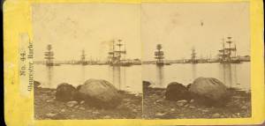
c.1870 Stereograph card Cape Ann Museum Library & Archive
Also filed under: Historic Photographs » // Rockport, Mass. - Thacher Island Twin Lighthouses »
c.1870 Stereograph card Cape Ann Museum Library & Archive
Also filed under: Historic Photographs » // Rockport, Mass. - Thacher Island Twin Lighthouses »
c.1870 Stereograph card Cape Ann Museum Library & Archive
Also filed under: Historic Photographs » // Rockport, Mass. - Thacher Island Twin Lighthouses »
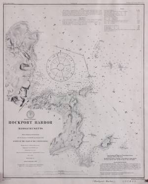
Survey of the Coast of the United States, Washington, D.C.
Collection of Erik Ronnberg
Also filed under: Maps »
The bark "Eastern Star" was under ownership of the Eastern Star Line, which was established in June of 1858 and discontinued at the end of that year.
– Erik Ronnberg
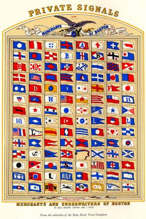
As reproduced in Yankee Sailing Ship Cards by Allan Forbes and Ralph M. Eastman (Boston: State Street Trust Company, 1948).
Also filed under: Forbes, Robert Bennet » // Signal Systems (Flags & Maritime Codes) »
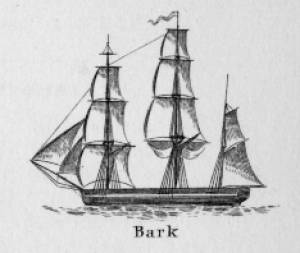
In the ninteenth century, the term "bark" was applied to a large sailing vessel having three masts, the first two (fore and main) being square-rigged; the third (mizzen), fore-and-aft rigged. The reduced square-rig made the vessel easier and more economical to handle, using a smaller crew. (1)
Barks had significant presence in mid-nineteenth-century America, as indicated by Lane’s depictions of them. Hardly any are to be found in his scenes of major ports, but some do appear in his Cape Ann scenes (see The Fort and Ten Pound Island, Gloucester (Harbor Scene), 1848 (inv. 58), View of Gloucester, 1859 (inv. 91), Gloucester Harbor, 1850s (inv. 391), and Bark "Eastern Star" of Boston, 1853 (inv. 571)), also in views of other small ports and of coastal shipping (see Clipper Ship "Southern Cross" in Boston Harbor, 1851 (inv. 253), Merchantmen Off Boston Harbor, 1853 (inv. 267), Approaching Storm, Owl's Head, 1860 (inv. 399), and Bark "Mary", n.d. (inv. 629)).
Brigs, and to a lesser extent ships, were the vessels of choice for Gloucester’s foreign trade in the first half of the nineteenth century. They brought cargos from the West Indies, South America, and Europe, anchoring in the deeper parts of the Inner Harbor while lighters off-loaded the goods and landed them at the wharves in Harbor Cove, by then too shallow for the newer, larger merchant vessels coming into use. (2) By mid-century, barks were gradually replacing brigs and ships, while the trade with Surinam was removed to Boston in 1860. (3)
Some bulk cargos still had to be landed in Gloucester, salt for curing fish being the most important. “Salt barks” brought Tortugas salt from the West Indies, and in the 1870s, Italian salt barks began bringing Trapani salt from Sicily. The importation of salt by sailing ships ended with the outbreak of World War I. (4)
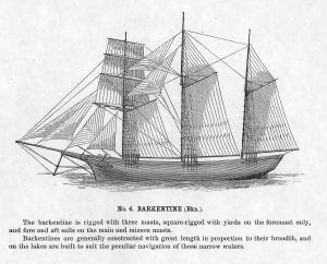
The term barkentine, like the bark, pre-dates the nineteenth century, but in the mid- to late 1800s referred to a large vessel of three masts (or more), with only the fore mast square-rigged, the others being fore-and-aft-rigged. In Lane’s time, the term was little known in the United States, while many other names were coined for the rig. One of these early terms was demi-bark, probably from the French demi-barque, which was applied to a very different kind of vessel. (5) Lane’s depictions of these rigs include a lithograph of the steam demi-bark "Antelope" View of Newburyport, (From Salisbury), 1845 (inv. 499) and at least three depictions of Cunard steamships The "Britannia" Entering Boston Harbor, 1848 (inv. 49), Cunard Steamship Entering Boston Harbor, n.d. (inv. 197), and Cunard Liner "Britannia", 1842 (inv. 259). (6) None of these subjects typify the barkentine rig as applied to sails-only rigs as they developed in the years after Lane’s death.
– Erik Ronnberg (May, 2015)
References:
1. R[ichard] H[enry] Dana, Jr., The Seaman's Friend (Boston; Thomas Groom & Co., 1841. 13th ed., 1873), 97 and Plate IV with captions; and M.H. Parry, et al., Aak to Zumbra: A Dictionary of the World's Watercraft (Newport News, VA: The Mariners’ Museum, 2000), 43.
2. Alfred Mansfield Brooks, Gloucester Recollected (Gloucester, MA: Peter Smith, 1974), 56, note 10; 67, note 7.
3. James R. Pringle, History of the Town and City of Gloucester (1892. Reprint: Gloucester, MA, 1997), 106–08.
4. Raymond McFarland, A History of the New England Fisheries (Philadelphia: University of Pennsylvania, 1911), 95–96; and Mark Kurlansky, Salt: A World History (New York: Walker & Co., 2002), 419–420.
5. Parry, 44, 167. Dana has neither definition nor illustration of this rig.
6. J[ohn] W. Griffiths, “The Japan and China Propeller Antelope," U.S. Nautical Magazine III (October 1855): 11–17. This article includes an impression of Lane’s lithograph on folded tissue.
c.1875 Stereograph card Cape Ann Museum Library & Archive
This view of Gloucester's Inner Harbor shows three square-rigged vessels in the salt trade at anchor. The one at left is a (full-rigged) ship; the other two are barks. By the nature of their cargos, they were known as "salt ships" and "salt barks" respectively. Due to their draft (too deep to unload at wharfside) they were partially unloaded at anchor by "lighters" before being brought to the wharves for final unloading.
– Erik Ronnberg
Also filed under: Historic Photographs » // Salt » // Waterfront, Gloucester »

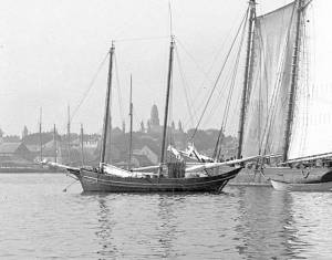
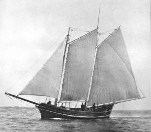
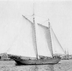
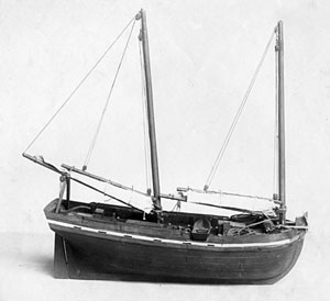
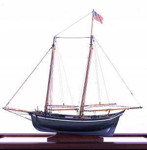
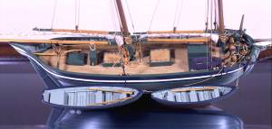
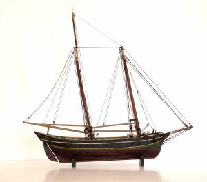
The colonial American shallop is the ancestor of many regional types of New England fishing craft found in Lane's paintings and drawings, including "New England Boats" (known as "boats" and discussed elsewhere), and later descendents, such as "Chebacco Boats," "Dogbodies," and "Pinkies."
These boats were very common work boat types on Cape Ann throughout the 1800s. They were primarily used for inshore coastal fishing, which included lobstering, gill-netting, fish-trapping, hand-lining, and the like. They were usually sailed by one or two men, sometimes with a boy, and could be rowed as well as sailed. An ordinary catch would include rock cod, flounder, fluke, dabs, or other small flat fish. The catch would be eaten fresh, or salted and stored for later consumption, or used as bait fish. Gill-netting would catch herring and alewives when spawning. Wooden lobster traps were marked with buoys much as they are today, and hauled over the low sides of the boat, emptied of lobsters and any by-catch, re-baited and thrown back.
CHEBACCO BOATS AND PINKIES
In the Chebacco Parish of the Ipswich Colony, a larger version of the colonial shallop evolved to a heavily built two-masted boat with either a sharp or square stern. This development included partial decking at bow and stern, the former as a cuddy which was fitted with crude bunks and a brick fireplace for cooking. Further development provided midship decking over a fish hold with standing rooms fore and aft for fishing. At this stage, low bulwarks replaced simple rails and in the double-enders were extended aft beyond the rudderhead to form a “pinched,” or “pink“ stern. Some time in the second half of the eighteenth century, boats with these characteristics became known as Chebacco Boats. The squarestern versions were called Dogbodies, for reasons now forgotten. (1)
Chebacco Boats became the vessels of choice for Cape Ann fishermen working coastal grounds for cod, mackerel, herring, and groundfish with hook and line or with nets. This did not prevent them from venturing further, particularly in pursuit of migrating schools of mackerel. The “Bashalore,” a corruption of the Bay of Chaleur in the Gulf of St. Lawrence, was a favorite destination for Cape Ann Fishermen who fished for mackerel in that region. (2)
Lane undoubtedly saw Chebacco Boats in the years prior to his move to Boston, but if he made drawings or paintings of them in that period, none have come to light. A small lithograph, titled “View of the Old Fort and Harbor 1837,” is attributed to him, but the vessels and wharf buildings are too crudely drawn to warrant this undocumented claim. (3) Lane did see and render accurately the Chebacco Boat’s successor the Pinky—which was larger and had a schooner rig (two masts, main sail, fore sail, jib, and main topmast staysail).
Schooners with pinksterns were recorded early in the 18th century later that there were models and graphic representations of hull form and rig (Ref. 4). By then, the pinky was very similar in hull form to Chebacco Boats, and some Chebacco Boats were converted to pinkies by giving them schooner rigs. A pinky in Lane’s The Old Fort and Ten Pound Island, Gloucester, 1850s (inv. 30) (misdated 1850s, more likely mid-1840s) is quite possibly an example of such a conversion.
Lane’s depictions of pinkies in Massachusetts waters are numerous and sometimes very informative. Examples in his views of Gloucester Harbor portray them at various angles, from broadside (see Gloucester Harbor from Rocky Neck, 1844 (inv. 14), The Old Fort and Ten Pound Island, Gloucester, 1850s (inv. 30), and View of the Town of Gloucester, Mass., 1836 (inv. 86)) to stern (see The Western Shore with Norman's Woe, 1862 (inv. 18), The Old Fort and Ten Pound Island, Gloucester, 1850s (inv. 30), and Gloucester Harbor, 1850s (inv. 391)), but few, if any, bow views. His portrayals of pinkies in Boston Harbor and vicinity are more in the foreground and more generous in detail. The earliest of these, from 1845, shows a pinky getting underway in a hurry as the yacht "Northern Light" bears down on her in The Yacht "Northern Light" in Boston Harbor, 1845 (inv. 268). A late harbor view (id ) offers a rare bow view.
Like the Chebacco Boat, the pinky was primarily a fishing vessel, doing much the same kind of fishing in coastal waters, but large enough to venture further offshore to work on the banks in the Gulf of Maine in pursuit of the cod. By the 1820s, pinkies reached their largest size: 50 to 60 feet on deck. Beyond that size called for a different deck arrangement and higher rails, so men could stand on deck and fish from the rails – an arrangement offered by the banks fishing schooner. (5)
What is perhaps Lane’s most detailed and narrative view of a pinky appears in Becalmed Off Halfway Rock, 1860 (inv. 344) and dominates the right foreground. Fitted-out for mackerel gillnetting, she has a dory and a wherry in tow, the latter with the net in the stern. The crew is relaxed, enjoying the evening calm as the vessel heads for port. The barrels on deck are filled with freshly caught mackerel, which will be sold as such when landed, most likely at Gloucester. This pinky was probably fishing on Stellwagen Bank or Cape Cod Bay, which were good fishing grounds for mackerel, and close enough to Gloucester to make trips in smaller vessels worthwhile. To judge from his paintings, Lane found only a few pinkies in the parts of the Maine Coast he explored. Only one drawing (Southwest Harbor, Mount Desert, 1852 (inv. 184)) and two widely published paintings (Entrance of Somes Sound, Mount Desert, Maine, 1855 (inv. 347) and Bar Island and Mt. Desert Mountains from Somes Settlement, 1850 (inv. 401)) illustrate this type, and then at a distance. What is apparent is that pinkies in southern Maine did not differ markedly from those on the Massachusetts coast. Had Lane ventured further Down East, he might have found modifications to the type that reflected Canadian influences. (6)
– Erik Ronnberg
References:
1. William A. Baker, Sloops & Shallops (Barre, MA: Barre Publishing Co., 1966), 82–91; and Howard I. Chapelle, The American Fishing Schooners, 1825–1935 (New York: W.W. Norton & Co., 1973), 25–27.
2. G. Brown Goode, The Fisheries and Fishery Industries of the United States, Section V, Vol. I (Washington, DC: Government Printing Office, 1884–87), 275, 287, 298–300, 419–21, 425–32, 459–63.
3. John J. Babson, History of the Town of Gloucester, Cape Ann (Procter Bros., 1860, reprint: Gloucester, MA: Peter Smith, 1972), see lithograph facing p. 474.
4. Goode, 275–77, 280, 294–96.
5. Chapelle, 36–37.
6. Ibid., 45–54.
Glass plate negative
3 x 4 in.
Cape Ann Museum Library & Archive
#10112
Also filed under: Gloucester Harbor, Inner / Harbor Cove »
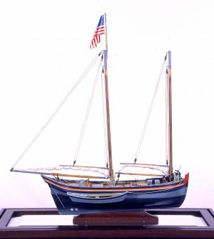
Also filed under: Ship Models »
Also filed under: Ship Models »
Also filed under: Ship Models » // Small Craft – Wherries, and Dories »
20" l. x 19" h. x 3 3/4" w. [not to scale]
Cape Ann Museum. Gift of Mr. J. Hollis Griffin, 1940 (891)
"Pinkys" were early nineteenth-century schooner-rigged derivations of Chebacco boats. This model is a good example of a traditional “sailor’s model,” or in this case, a sailmaker’s model, Mr. Nickerson having been a sailmaker.
Also filed under: Ship Models »

1860 In John J. Babson, History of the Town Gloucester (Gloucester, MA: Procter Brothers, 1860) Cape Ann Museum Library & Archives, Gloucester, Mass.
See p. 474.
View related catalogue entries (4) »
Also filed under: Babson History of the Town of Gloucester » // Fort (The) and Fort Point » // Gloucester Harbor, Inner / Harbor Cove » // Gloucester, Mass. - "Ten Pound Island Light » // Schooner (Coasting / Lumber / Topsail / Packet / Marsh Hay) » // Ten Pound Island »
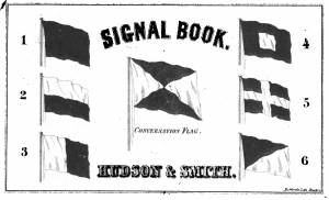
The use of signal flags, for ship-to-ship communication, generally preceded land-based chains of maritime semaphore stations, the latter using flags or rotating arms, until the advent of the electric or magnetic telegraph.
Until the end of the Napoleonic wars, merchant ships generally sailed in convoy as ordered by the escorting warship(s) using a few simple flags. Peace brought independent voyaging, the end of the convoy system, and the realization by various authorities that merchant vessels now needed their own separate means of signaling to each other. This resulted in a handful of rival codes, each with its individual flags and syntax. In general, they each had a section enabling ship identification and also a "vocabulary" section for transmitting selected messages. It was not until 1857 that a common Commercial Code became available for international use, only gradually replacing the earlier ones. All existed side by side for a decade or two.
Signal systems for American ships were originally intended to identify a vessel by name and owner; only later were more advanced systems developed to convey messages. Most basic were private signals, or "house flags", each of a different design or pattern, identifying the vessel's owner; identification charts were local and poorly distributed, limiting their usefulness. A secondary signal, a flag or large pennant bearing the vessel's name, was sometimes flown by larger ships, but pictorial records of them are uncommon. These private signal flags usually flew from the foremasthead or main masthead if a three master ship. Pilot boats had their own identifying flags, blue and white as seen in Spitfire Entering Boston Harbor, n.d. (inv. 536). Small vessels, such as schooners, often had a "tell-tale" pennant, an often-unmarked and often red flag, that was used to determine wind direction.
A numerical code flag system, identifying vessels by the code numbers, was introduced by Captain Frederick Marryat R.N. in 1817 for English vessels. American vessels soon adopted this system. Elford's "marine telegraphic system" was the first American equivalent to the Marryat code flags, first issued in 1823, and with changes, remaining in use until the late 1850s. Most of the signal flags on vessels depicted by Lane use Elford's; Brig "Antelope" in Boston Harbor, 1863 (inv. 43) is a noteworthy example of his depiction of Marryat's. The Elford's Code was popular in America on account of its simplicity and only required six blue and white flags. Eventually these changed to red and white, although it is unclear exactly when this happened. Instructions and a key ot the Elford's Code's use are included in successive editions of the Boston Harbor Signal Book.
Whereas the other codes employ at least ten flags of diverse shapes and colours, there are only six Elford flags in total, representing the numbers one to six. All are uniformly rectangular and monochrome in colour (either blue and white or red and white—or even black and white as in an early photograph). Selected from these six flags each individual vessel is allotted a combination of four flags to be prominently displayed as a vertical hoist. Reading from above down these convey its "designated number." Armed with this number and the type of vessel (e.g. ship, bark, brig, schooner /or steamer) the subject can be uniquely identified by reference to a copy of the Boston Harbor Signal Book for the appropriate year.
– A. Sam Davidson
As reproduced in Yankee Sailing Ship Cards by Allan Forbes and Ralph M. Eastman (Boston: State Street Trust Company, 1948).
Also filed under: "Eastern Star" (Bark) » // Forbes, Robert Bennet »
Harvard Depository: Widener (NAV 578.57)
For digitized version, click here.
Also filed under: Boston Harbor »
Boston: Eastburn's Press
New York Public Library
Complete book is included in Google Books, click here.
In The American Neptune 3, no. 3 (July 1943): 205–21.
Peabody Essex Museum
Descriptions of Marryat, Elford, Rogers, and commercial code signal systems, and private signals. Includes illustrations of flag systems with color keys.