An online project under the direction of the CAPE ANN MUSEUM
Catalogue Entry
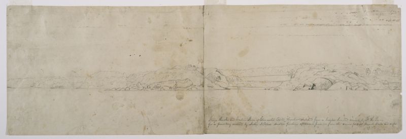
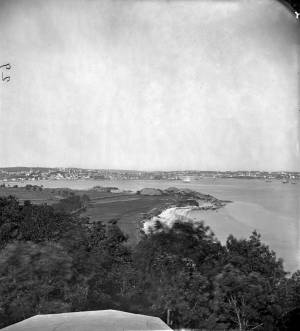
This drawing shows Gloucester's Western sSore from the Outer Harbor. Lane has included the prominent house Steepbank as well as the flagpole that had been erected above Fresh Water Cove, the entrance of which is visible on the left. Stage Rocks, Stage Head, and Half Moon Beach were well-known landmarks in Gloucester, and the field above the beach (Fisherman's Field) was the site of the first settlement in Gloucester in the seventeenth century.
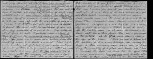
Lane's own writing on his pictures is virtually nonexistent, but in the Cape Ann Museum Library & Archive is a fragment of a letter describing his sketch of this scene. He wrote: "I yesterday made a sketch of Stage Fort and the surrounding scenery, from the water. Piper has given me an order for a picture from this point of view, to be treated as a sunset. I shall try to make something out of it, but it will require some management, as there is no foreground but water and vessels."
- Subject Types
: - Landscape Types
: - Cape Ann Locales
: - Objects
:
Historical Materials
Letter
Cape Ann Museum Library & Archive, Gloucester, Mass.
". . . will fully appreciate all that I have done in my garden, in ornamenting it, with flowers and plants, Rustic Arbours and Statues, and I only wish that you could be here to witness and enjoy his [Dr. J. L. Stevens] expressions of delight and interest, when a new flower attracts his attention, or some beauty of arrangement meets his eye. Samuel [B. Stevens of Castine] he tells me came up with the expectation of going on a voyage to Australia, but when he arrived in Boston he found the vessel with her compliment of men, and it is very uncertain if he goes in her. Your Mother and all at home are well. I yesterday made a sketch of Stage Fort and the surrounding scenery, from the water. Piper has given me an order for a picture from this point of view, to be treated as a sunset. I shall try to make something out of it, but it will require some management, as there is no foreground but water and vessels. One o’clock, it is very hot, the glass indicates 84° in my room, with the windows all open and a light breeze from the east, this is the warmest day . . .
. . . than devoting it to you. Since writing you last I have painted but one picture worth talking about and that one I intend for you if you should be pleased with it. It is a View of the beach between Stage Fort and Steep bank including Hovey’s Hill and residence, Fresh water cove and the point of land with the lone pine tree. Fessenden’s house, likewise comes into the picture. The effect is a mid day light with a cloudy sky, a patch of sunlight is thrown across the beach and the breaking waves, an old vessel lies stranded on the beach with two or three figures, there are a few vessels in the distance and the Field rocks likewise show at the left of the picture. I think you will be pleased with this picture, for it is a very picturesque scene especially the beach, as there are many rocks which come in to destroy the monotony of a plain sand beach, and I have so arranged the light and shade that the effect I think is very good indeed, however you will be better able to judge of that when you see it, the size is 20 x 33. . ."
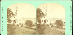
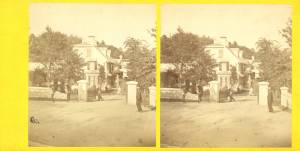
Brookbank was an early eighteenth-century white gambrel-roofed house on Fresh Water Cove which was owned and occupied by Samuel Sawyer and his ancestors. It is possible to trace apparent renovations to the house through Lane's pictures; at first it is depicted as a white house without dormers and a simple brown barn Fresh Water Cove, Gloucester, c.1864 (inv. 112); then dormers appear on the house and the barn is white with a cupola Fresh Water Cove, etc., from Dolliver's Neck, 1850s (inv. 113). In Gloucester from Brookbank, 1848 (inv. 42) a cobb wharf (log cabin-like structure) and boardwalk are visible. By Fresh Water Cove from Dolliver's Neck, Gloucester, Early 1850s (inv. 45) the house seems to have additions.
Stereograph card Cape Ann Museum Library & Archive
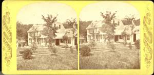
Stereo view of Brookbank guest house or boathouse.
Also filed under: Historic Photographs »
Published by Frank Rowell Cape Ann Museum Library & Archive
Stereograph card
Also filed under: Historic Photographs »
n.d. Stereographic card Cape Ann Museum Library & Archive
Penciled on reverse: "Mansion House, Brook Bank [sic], Sam'l Sawyer now Hammond, Freshwater Cove"
Also filed under: Historic Photographs » // Sawyer, Samuel »

44 x 34 in.
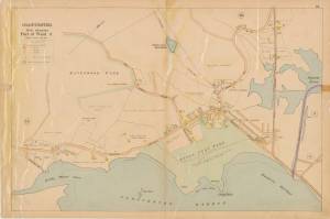
Henry Francis Walling, Map of the Towns of Gloucester and Rockport, Essex Co. Massachusetts. Philadelphia, A. Kollner, 1851
Cape Ann Museum Library & Archive
"Map of the Towns of Gloucester and Rockport, Massachusetts. H.F. Walling, Civil Engineer. John Hanson, Publisher. 1851. Population of Gloucester in 1850: 7,805. Population of Rockport in 1850: 3,213."
Also filed under: Annisquam River » // Dolliver's Neck » // Fresh Water Cove » // Gloucester Harbor, Outer » // Maps » // Norman's Woe » // Stage Rocks / Stage Fort / Stage Head » // Steepbank » // West Gloucester – Little River » // Western Shore »
Samuel Sawyer Papers
Cape Ann Museum Library & Archives
Archive Collection
"August 25. Called to see Mr. Lane to make a sketch of old Homestead for Haughtons."
Also filed under: Diaries / Ledgers / Etc. » // Haughton, James » // Sawyer, Samuel »
1860s Stereograph card Cape Ann Museum Library & Archive
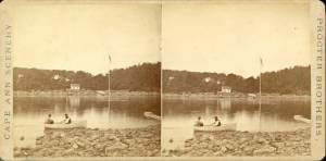
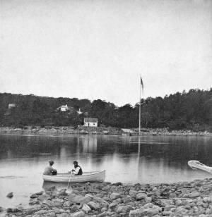
A view of a Cove on the western side of Gloucester Harbor, with the landing at Brookbank. Houses are seen in the woods back. A boat with two men is in the foreground.
Also filed under: American ensign / flag » // Fresh Water Cove » // Historic Photographs »
Stereograph card
Cape Ann Museum Library & Archive
Also filed under: Fresh Water Cove »
Steepbank (sometimes spelled "Steep Bank") was a house near Fresh Water Cove which, in Lane's time, served as a summer estate for brothers, Eben and Theron Dale. It had been built for “an artist” named “Mr. Eddy” in 1845, was next owned by a “Mr. Homer,” and then by a “Mr. C. B. Fessenden." Around 1858 it was purchased by Eben Dale.
Commonwealth of Massachusetts: Southern Essex District Registry of Deeds
1543 plan 0141_0002
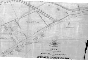
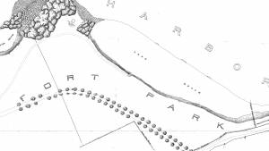
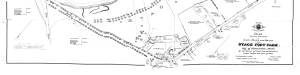
The third of the three plans has the references on it. "Plan showing the taking of land, flats and beach for Stage Fort Park…1898..."
Includes a reference to the home of Mary Turnbull which is Steepbank.
Also filed under: Maps » // Stage Rocks / Stage Fort / Stage Head »
c.1870 Stereograph card Cape Ann Museum Library & Archive
Also filed under: Gloucester – City Views » // Half Moon Beach » // Historic Photographs » // Stage Rocks / Stage Fort / Stage Head »
Newsprint
From bound volume owned by publisher Francis Procter
Collection of Fred and Stephanie Buck
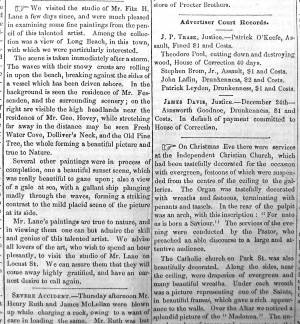
"We visited the studio of Mr. Fitz H. Lane a few days since, and were much pleased in examining some fine paintings from the pencil of this talented artist. Among the collection was a view of Long Beach, in this town, with which we were particularly interested.
The scene is taken immediately after a storm. The waves with their snowy crests are rolling in upon the beach, breaking against the sides of a vessel which has been driven ashore. In the background is seen the residence of Mr. Fessenden, and the surrounding scenery; on the right are visible the high headlands near the residence of Mr. Geo. Hovey, while stretching far away in the distance may be seen Fresh Water Cove, Dolliver's Neck, and the Old Pine Tree, the whole forming a beautiful picture and true to Nature.
Several other paintings were in process of completion, one a beautiful sunset scene, which was really beautiful to gaze upon; also a view of a gale at sea, with a gallant ship plunging madly through the waves, forming a striking contrast to the mild placid scene of the picture at its side.
Mr. Lane's paintings are true to nature, and in viewing them one can but admire the skill and genius of this talented artist, We advise all lovers of the art, who wish to spend an hour pleasantly, to visit the studio of Mr. Lane on Locust St. We can assure them that they will come away highly gratified, and have an earnest desire to call again." (1)
(1) See p. 2, column 3, Courtesy of the American Antiquarian Society
Also filed under: Chronology » // Dolliver's Neck » // Fessenden, C. B. » // Fresh Water Cove » // Lone Pine » // Newspaper / Journal Articles » // Studio Descriptions »
44 x 34 in.
Henry Francis Walling, Map of the Towns of Gloucester and Rockport, Essex Co. Massachusetts. Philadelphia, A. Kollner, 1851
Cape Ann Museum Library & Archive
"Map of the Towns of Gloucester and Rockport, Massachusetts. H.F. Walling, Civil Engineer. John Hanson, Publisher. 1851. Population of Gloucester in 1850: 7,805. Population of Rockport in 1850: 3,213."
Also filed under: Annisquam River » // Brookbank » // Dolliver's Neck » // Fresh Water Cove » // Gloucester Harbor, Outer » // Maps » // Norman's Woe » // Stage Rocks / Stage Fort / Stage Head » // West Gloucester – Little River » // Western Shore »
c.1860 Stereograph card Cape Ann Museum Library & Archive
Taken from Steepbank, on the western side of Gloucester Harbor, and showing a small boat at anchor in the cove, then the Neck, and the sea beyond.
Also filed under: Dolliver's Neck » // Fresh Water Cove » // Historic Photographs » // Lone Pine »
Letter
Cape Ann Museum Library & Archive, Gloucester, Mass.
". . . will fully appreciate all that I have done in my garden, in ornamenting it, with flowers and plants, Rustic Arbours and Statues, and I only wish that you could be here to witness and enjoy his [Dr. J. L. Stevens] expressions of delight and interest, when a new flower attracts his attention, or some beauty of arrangement meets his eye. Samuel [B. Stevens of Castine] he tells me came up with the expectation of going on a voyage to Australia, but when he arrived in Boston he found the vessel with her compliment of men, and it is very uncertain if he goes in her. Your Mother and all at home are well. I yesterday made a sketch of Stage Fort and the surrounding scenery, from the water. Piper has given me an order for a picture from this point of view, to be treated as a sunset. I shall try to make something out of it, but it will require some management, as there is no foreground but water and vessels. One o’clock, it is very hot, the glass indicates 84° in my room, with the windows all open and a light breeze from the east, this is the warmest day . . .
. . . than devoting it to you. Since writing you last I have painted but one picture worth talking about and that one I intend for you if you should be pleased with it. It is a View of the beach between Stage Fort and Steep bank including Hovey’s Hill and residence, Fresh water cove and the point of land with the lone pine tree. Fessenden’s house, likewise comes into the picture. The effect is a mid day light with a cloudy sky, a patch of sunlight is thrown across the beach and the breaking waves, an old vessel lies stranded on the beach with two or three figures, there are a few vessels in the distance and the Field rocks likewise show at the left of the picture. I think you will be pleased with this picture, for it is a very picturesque scene especially the beach, as there are many rocks which come in to destroy the monotony of a plain sand beach, and I have so arranged the light and shade that the effect I think is very good indeed, however you will be better able to judge of that when you see it, the size is 20 x 33. . ."
Commonwealth of Massachusetts: Southern Essex District Registry of Deeds
1543 plan 0141_0001
The third of the three plans has the references on it “Plan showing the taking of land, flats and beach for Stage Fort Park…1898…”
Includes a reference to the home of Mary Turnbull which is Steepbank.
Also filed under: Field Beach / Crescent (or Cressy's) Beach / Long Beach » // Maps » // Stage Rocks / Stage Fort / Stage Head »
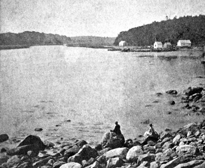
Fresh Water Cove is located on the west side of Gloucester’s Outer Harbor. It is protected from the harbor waters and the south-easterly seas by the arm of Dolliver’s Neck reaching north from the western shore. It’s a small, very still cove, only a few hundred yards from its mouth to the innermost shore.
The cove was visited by Samuel de Champlain in 1606. He was the first known European to enter Gloucester Harbor, which he named Le Beauport. He named Fresh Water Cove for the fresh water springs he found there, one a bit up from the shore, the other flowing below the high tide line and only accessible at half tide.
The cove, while very well protected from the weather, is small and very shallow at low tide and was never suitable for any large vessels, though there were fishing shacks along the shores edge and small boats were easily pulled up on the sand and salt marsh in its inner recesses. There was a wharf built in the early 1800s to service a granite quarry just up the hill from the cove, which could apparently handle larger vessels at high tide.
In Lane’s time, the most significant landmark from the cove was Brookbank, the Sawyer homestead where Samuel E. Sawyer was born in 1818. Sawyer made a fortune in Boston and returned to Brookbank every summer for fifty years. He became one of Gloucester’s first philanthropists. Lane did a series of paintings from the fields in front of Brookbank looking to the east from the house over Fresh Water Cove, the arm of Dolliver’s Neck and the harbor beyond. He also painted the opposite view in Fresh Water Cove from Dolliver's Neck, Gloucester, Early 1850s (inv. 45) looking west from Dolliver’s Neck over the cove to the Sawyer homestead and surrounding shoreline. Each of these paintings captures the perfect serenity of a high summer day in this secluded cove just off the busy harbor.
Stereograph card
Cape Ann Museum Library & Archive
Also filed under: Brookbank »
44 x 34 in.
Henry Francis Walling, Map of the Towns of Gloucester and Rockport, Essex Co. Massachusetts. Philadelphia, A. Kollner, 1851
Cape Ann Museum Library & Archive
"Map of the Towns of Gloucester and Rockport, Massachusetts. H.F. Walling, Civil Engineer. John Hanson, Publisher. 1851. Population of Gloucester in 1850: 7,805. Population of Rockport in 1850: 3,213."
Also filed under: Annisquam River » // Brookbank » // Dolliver's Neck » // Gloucester Harbor, Outer » // Maps » // Norman's Woe » // Stage Rocks / Stage Fort / Stage Head » // Steepbank » // West Gloucester – Little River » // Western Shore »
c.1860 Stereograph card Cape Ann Museum Library & Archive
Taken from Steepbank, on the western side of Gloucester Harbor, and showing a small boat at anchor in the cove, then the Neck, and the sea beyond.
Also filed under: Dolliver's Neck » // Historic Photographs » // Lone Pine » // Steepbank »
Newspaper
"Mr. Lane has just completed a third picture of the Western Shore of Gloucester Harbor, including the distance from 'Norman's Woe Rock' to 'Half Moon Beach.' It was painted for Mr. William E. Coffin of Boston, and will be on exhibition at the artist's rooms for only a few days; we advise all our readers who admire works of art, and would see one of the best pictures Mr. Lane has ever executed..."
"...solitary pine, so many years a familiar object and landmark to the fisherman."

Newsprint
From bound volume owned by publisher Francis Procter
Collection of Fred and Stephanie Buck
"We visited the studio of Mr. Fitz H. Lane a few days since, and were much pleased in examining some fine paintings from the pencil of this talented artist. Among the collection was a view of Long Beach, in this town, with which we were particularly interested.
The scene is taken immediately after a storm. The waves with their snowy crests are rolling in upon the beach, breaking against the sides of a vessel which has been driven ashore. In the background is seen the residence of Mr. Fessenden, and the surrounding scenery; on the right are visible the high headlands near the residence of Mr. Geo. Hovey, while stretching far away in the distance may be seen Fresh Water Cove, Dolliver's Neck, and the Old Pine Tree, the whole forming a beautiful picture and true to Nature.
Several other paintings were in process of completion, one a beautiful sunset scene, which was really beautiful to gaze upon; also a view of a gale at sea, with a gallant ship plunging madly through the waves, forming a striking contrast to the mild placid scene of the picture at its side.
Mr. Lane's paintings are true to nature, and in viewing them one can but admire the skill and genius of this talented artist, We advise all lovers of the art, who wish to spend an hour pleasantly, to visit the studio of Mr. Lane on Locust St. We can assure them that they will come away highly gratified, and have an earnest desire to call again." (1)
(1) See p. 2, column 3, Courtesy of the American Antiquarian Society
Also filed under: Chronology » // Dolliver's Neck » // Fessenden, C. B. » // Lone Pine » // Newspaper / Journal Articles » // Steepbank » // Studio Descriptions »
1860s Stereograph card Cape Ann Museum Library & Archive
A view of a Cove on the western side of Gloucester Harbor, with the landing at Brookbank. Houses are seen in the woods back. A boat with two men is in the foreground.
Also filed under: American ensign / flag » // Brookbank » // Historic Photographs »
4 x 5 in.
Cape Ann Museum Library & Archive
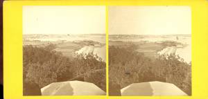
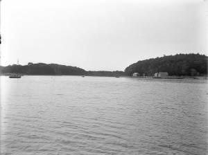
Freshwater Cove and Dolliver's Neck from the water off Stage Fort.
Also filed under: Dolliver's Neck »
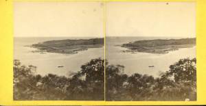
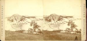
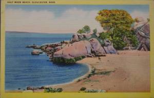
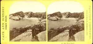
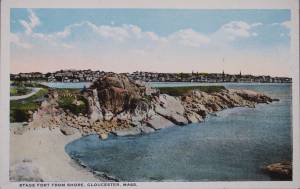
Half Moon Beach is a small crescent of sand, nestled into Stage Fort Park, between Stage Point (where the remains of a Revolutionary War earthworks fort still stands) and a large ledge outcropping that on the far side houses the tablet commemorating the original 1623 settlement of the area by the Dorchester Company. At the time Lane painted his views of the Harbor in which one can see this beach, the entire little peninsula, once known as Fisherman's Field, was probably owned by the B. K. Hough family. The area, including this beach, is now public. From the beach, one can see much of the Outer Harbor, Pavilion Beach, and Ten Pound Island.
– Sarah Dunlap (June, 2015)
c.1870 Stereograph card Cape Ann Museum Library & Archive
Also filed under: Historic Photographs » // Stage Rocks / Stage Fort / Stage Head » // Western Shore »
c.1870 Stereograph card Cape Ann Museum Library & Archive
Also filed under: Historic Photographs »
Newspaper
"Mr. Lane has just completed a third picture of the Western Shore of Gloucester Harbor, including the distance from 'Norman's Woe Rock' to 'Half Moon Beach.' It was painted for Mr. William E. Coffin of Boston, and will be on exhibition at the artist's rooms for only a few days; we advise all our readers who admire works of art, and would see one of the best pictures Mr. Lane has ever executed..."
"...solitary pine, so many years a familiar object and landmark to the fisherman."
c.1870 Stereograph card Cape Ann Museum Library & Archive
Also filed under: Gloucester – City Views » // Historic Photographs » // Stage Rocks / Stage Fort / Stage Head » // Steepbank »
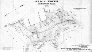
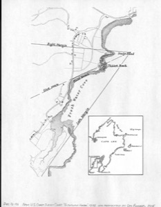
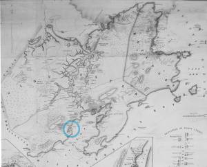
29 x 25 in.
Cape Ann Museum Library & Archive (#089)
Ernest Bowditch was a landscape gardener. This map shows some of the various names of landmarks around Stage Rocks.
Also filed under: Field Beach / Crescent (or Cressy's) Beach / Long Beach » // Maps » // Stage Rocks / Stage Fort / Stage Head »
The Stage, as it was known in Lane’s time, now Stage Fort Park, rises from the western shore of the Outer Harbor, just south and west of the Cut and the Blynman Bridge as you leave Gloucester. This was the first settlement of the Massachusetts Bay Colony in 1623 where fourteen men of the Dorchester Company landed and tried in vain to settle and survive through a combination of fishing and farming. They were successful at neither, and in 1626 they moved on and founded Salem.
During the Revolution the Gloucester patriots built a fort on the north side of Half Moon Beach to defend against British invaders which was never needed. The fort was restored for the War of 1812 and again for the Civil War, but again saw no action.
During Lane’s lifetime this area was the Hough farm. Townspeople were generally given free run of the place for strolling and picnics overlooking the harbor. The enormous rounded boulders and ledge outcroppings rose dramatically from the fields above the harbor without the tree cover that partially obscures them today.
Lane did numerous paintings of this area, including many views looking westward from the vantage point onboard a boat in the harbor. In Stage Rocks and the Western Shore of Gloucester Outer Harbor, 1857 (inv. 8) the Stage Rocks frame the west side of Gloucester Harbor and provided a peaceful and bucolic counterpoint to the intense activity of the city waterfront only a mile away across the harbor. Lane also painted the Stage Rocks from the beach just to the north near the Cut and Field Beach, which is on the southern side of the Stage Rocks facing out the harbor entrance to the sea.
Commonwealth of Massachusetts: Southern Essex District Registry of Deeds
1543 plan 0141_0002
The third of the three plans has the references on it. "Plan showing the taking of land, flats and beach for Stage Fort Park…1898..."
Includes a reference to the home of Mary Turnbull which is Steepbank.
Also filed under: Maps » // Steepbank »
c.1870 Stereograph card Cape Ann Museum Library & Archive
Also filed under: Gloucester – City Views » // Half Moon Beach » // Historic Photographs » // Steepbank »
44 x 34 in.
Henry Francis Walling, Map of the Towns of Gloucester and Rockport, Essex Co. Massachusetts. Philadelphia, A. Kollner, 1851
Cape Ann Museum Library & Archive
"Map of the Towns of Gloucester and Rockport, Massachusetts. H.F. Walling, Civil Engineer. John Hanson, Publisher. 1851. Population of Gloucester in 1850: 7,805. Population of Rockport in 1850: 3,213."
Also filed under: Annisquam River » // Brookbank » // Dolliver's Neck » // Fresh Water Cove » // Gloucester Harbor, Outer » // Maps » // Norman's Woe » // Steepbank » // West Gloucester – Little River » // Western Shore »
c.1870 Stereograph card Cape Ann Museum Library & Archive
Also filed under: Half Moon Beach » // Historic Photographs » // Western Shore »
c.1870 Stereograph card Cape Ann Museum Library & Archive
Also filed under: Gloucester – City Views » // Historic Photographs »
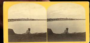
c.1890 Stereograph card Cape Ann Museum Library & Archive
"In the foreground is a clear sheet of water which washes upon the beach beyond. The Pavilion is quite prominent, while upon the rising background can be seen the steeples of the several churchs, the tower of the first Town House, and the Collins School House."
Also filed under: Gloucester – City Views » // Historic Photographs » // Pavilion Hotel »
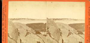
Cape Ann Museum Library & Archive
Stage Fort from Hough's Farm, showing a panorama of the harbor from Pavilion Beach to Fort Point and Rocky Neck.
Also filed under: Field Beach / Crescent (or Cressy's) Beach / Long Beach »

c.1870 Stereograph card Procter Brothers, Publisher Cape Ann Museum Library & Archive
Also filed under: Gloucester Harbor, Outer » // Historic Photographs »
Commonwealth of Massachusetts. Southern Essex District Registry of Deeds. 1543 plan 0141_0003
salemdeeds.com
The third of the three plans has the references on it “Plan showing the taking of land, flats and beach for Stage Fort Park…1898…"
Includes a reference to the home of “Mary Turnbull” which is Steepbank.
Also filed under: Maps »
Commonwealth of Massachusetts: Southern Essex District Registry of Deeds
1543 plan 0141_0001
The third of the three plans has the references on it “Plan showing the taking of land, flats and beach for Stage Fort Park…1898…”
Includes a reference to the home of Mary Turnbull which is Steepbank.
Also filed under: Field Beach / Crescent (or Cressy's) Beach / Long Beach » // Maps » // Steepbank »
Colored lithograph
Cape Ann Museum Library and Archive
Also filed under: Western Shore »
29 x 25 in.
Cape Ann Museum Library & Archive (#089)
Ernest Bowditch was a landscape gardener. This map shows some of the various names of landmarks around Stage Rocks.
Also filed under: Field Beach / Crescent (or Cressy's) Beach / Long Beach » // Half Moon Beach » // Maps »
The ensign of the United States refers to the flag of the United States when used as a maritime flag to indentify nationality. As required on entering port, a vessel would fly her own ensign at the stern, but a conventional token of respect to the host country would be to fly the flag of the host country (the United States in Boston Harbor, for example) at the foremast. See The "Britannia" Entering Boston Harbor, 1848 (inv. 49) for an example of a ship doing this. The American ensign often had the stars in the canton arranged in a circle with one large star in the center; an alternative on merchant ensigns was star-shaped constellation. In times of distress a ship would fly the ensign upside down, as can be seen in Wreck of the Roma, 1846 (inv. 250).
The use of flags on vessels is different from the use of flags on land. The importance and history of the flagpole in Fresh Water Cove in Gloucester is still being studied.
The modern meaning of the flag was forged in December 1860, when Major Robert Anderson moved the U.S. garrison from Fort Moultrie to Fort Sumter in Charleston Harbor. Adam Goodheart argues this was the opening move of the American Civil War, and the flag was used throughout northern states to symbolize American nationalism and rejection of secessionism.
Before that day, the flag had served mostly as a military ensign or a convenient marking of American territory, flown from forts, embassies, and ships, and displayed on special occasions like American Independence day. But in the weeks after Major Anderson's surprising stand, it became something different. Suddenly the Stars and Stripes flew—as it does today, and especially as it did after the September 11 attacks in 2001—from houses, from storefronts, from churches; above the village greens and college quads. For the first time American flags were mass-produced rather than individually stitched and even so, manufacturers could not keep up with demand. As the long winter of 1861 turned into spring, that old flag meant something new. The abstraction of the Union cause was transfigured into a physical thing: strips of cloth that millions of people would fight for, and many thousands die for.
– Adam Goodheart, Prologue of 1861: The Civil War Awakening (2011).
1860s Stereograph card Cape Ann Museum Library & Archive
A view of a Cove on the western side of Gloucester Harbor, with the landing at Brookbank. Houses are seen in the woods back. A boat with two men is in the foreground.
Also filed under: Brookbank » // Fresh Water Cove » // Historic Photographs »
Courtesy American Antiquarian Society, Worcester, Mass. (CL.F9116.011.1854 CL.F9116.011.1854)
Also filed under: Oak Hall »
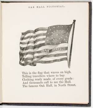
Courtesy American Antiquarian Society, Worcester, Mass. (CL.F9116.011.1854)
Also filed under: Oak Hall »
Lane made a painting for Captain and Mrs. Frank Dale from the drawing Stage Rocks and Western Shore of Gloucester Outer Harbor, 1857 (inv. 106).
John J. Piper’s life intersected with that of Fitz Henry Lane on several occasions. Both men joined the Gloucester Lyceum in the 1840s, signing the register in succession. In 1849, Piper and Lane helped organize Gloucester’s annual Fourth of July observances and rode together in an open carriage in the celebratory procession. John J. Piper, both of his wives and his son are all buried in Oak Grove Cemetery, adjacent to the grave of Fitz Henry Lane.
On at least two occasions, Piper ordered paintings done by Lane: one based on a pencil drawing entitled "View at Bass Rocks Looking Eastward," and the other from a drawing of Stage Rocks and the Western Shore of Gloucester Outer Harbor (1857). What became of these two paintings following Piper’s death in 1869 remains unknown.
John J. Piper was born in Stratham, New Hampshire, in 1825. He began teaching school in his hometown at the age of fourteen and at the age of sixteen, moved to Gloucester, Massachusetts where he also found work as a teacher. By 1842, he was employed in the Gloucester public schools as a teacher in the girl’s high school. During the 1846–47 school year, Piper was moved to Gloucester’s Numbers 1 & 2 High School for Boys.
While Piper had an early interest in teaching, his true passion was in printing and newspapers. In 1847, under his leadership, the boys’ high school began printing a small newspaper called The Germ which was envisioned as a means for Gloucester boys to improve their composition skills. While officials were pleased at first with Piper’s project, regular visits to the classroom revealed a growing undercurrent of resentment and disrespectfulness among students who were being kept after school to work on the newspaper. Absenteeism became a problem, student progress dropped and mid-way through the 1848 year Piper’s tenure with the Gloucester schools was abruptly terminated.
Later that same year, Piper focused his attention on the world of newspapers, starting a semi-weekly publication called the Gloucester News and Messenger. In 1851, the publication was taken over by the Gloucester Telegraph, and Piper moved to Fitchburg, Massachusetts, where he started The Reveille, a political paper that advocated the principals and policies of the Whig party.
Despite his move to Fitchburg, Piper maintained his connections to Cape Ann. In 1856, he and Eliza Sayward of Gloucester were married. Following Eliza’s death a year later, Piper married her younger sister Mary. Together they had one child, a son born in 1868. John J. Piper died in 1869; Mary passed away shortly thereafter, leaving their young son to be raised by his maternal grandmother who lived at the corner of Middle and Washington Streets in Gloucester.
– Martha Oaks
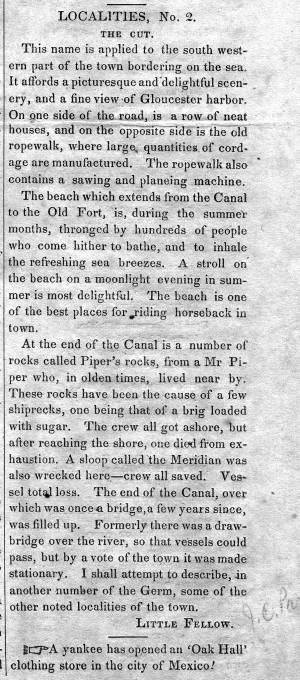
1848 Newsprint D14-7 Cape Ann Museum Library & Archive
A short article entitled "The Cut," and signed "Little Fellow" describes the southwestern part of Gloucester and the beach between the Canal and the Old Fort.
Also filed under: Cut, The (Stacy Blvd.) » // Ropewalk »
Letter
Cape Ann Museum Library & Archive, Gloucester, Mass.
". . . will fully appreciate all that I have done in my garden, in ornamenting it, with flowers and plants, Rustic Arbours and Statues, and I only wish that you could be here to witness and enjoy his [Dr. J. L. Stevens] expressions of delight and interest, when a new flower attracts his attention, or some beauty of arrangement meets his eye. Samuel [B. Stevens of Castine] he tells me came up with the expectation of going on a voyage to Australia, but when he arrived in Boston he found the vessel with her compliment of men, and it is very uncertain if he goes in her. Your Mother and all at home are well. I yesterday made a sketch of Stage Fort and the surrounding scenery, from the water. Piper has given me an order for a picture from this point of view, to be treated as a sunset. I shall try to make something out of it, but it will require some management, as there is no foreground but water and vessels. One o’clock, it is very hot, the glass indicates 84° in my room, with the windows all open and a light breeze from the east, this is the warmest day . . .
. . . than devoting it to you. Since writing you last I have painted but one picture worth talking about and that one I intend for you if you should be pleased with it. It is a View of the beach between Stage Fort and Steep bank including Hovey’s Hill and residence, Fresh water cove and the point of land with the lone pine tree. Fessenden’s house, likewise comes into the picture. The effect is a mid day light with a cloudy sky, a patch of sunlight is thrown across the beach and the breaking waves, an old vessel lies stranded on the beach with two or three figures, there are a few vessels in the distance and the Field rocks likewise show at the left of the picture. I think you will be pleased with this picture, for it is a very picturesque scene especially the beach, as there are many rocks which come in to destroy the monotony of a plain sand beach, and I have so arranged the light and shade that the effect I think is very good indeed, however you will be better able to judge of that when you see it, the size is 20 x 33. . ."
Marks: Inscribed upper left (in red ink): 60 [numbering system used by curator A. M. Brooks upon Samuel H. Mansfield's donation of the drawings to the Cape Ann Museum]