An online project under the direction of the CAPE ANN MUSEUM
Historical Materials: Gloucester Buildings & Businesses
Historical Materials » Gloucester Buildings & Businesses » Gloucester – City Views
You have navigated to this pages from catalog entry: Gloucester Harbor, 1852 (inv. 38)
Gloucester – City Views
View related Fitz Henry Lane catalog entries (4) »
High Street is the old name for the west end of what is now Prospect Street. Originally, it was Back Street, to go with Middle and Front Streets. Front Street became Main Street. Middle Street is still Middle Street. Back Street became High Street, and then adopted the name Prospect Street which already had gone from Pleasant Street east.
– Sarah Dunlap
Glass plate negative from Benham Collection
Cape Ann Museum Library & Archive
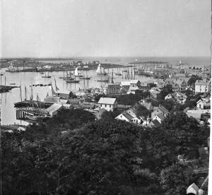
View of Gloucester Harbor from Friend Street Wharves, Five Pound Island segment at far left, Rocky Neck, Eastern Point and Ten Pound Island in background.
Also filed under: Eastern Point » // Five Pound Island »
44 x 34 in.
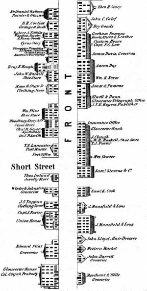
Henry Francis Walling, Map of the Towns of Gloucester and Rockport, Essex Co. Massachusetts. Philadelphia, A. Kollner, 1851
Cape Ann Museum Library & Archive
"Map of the Towns of Gloucester and Rockport, Massachusetts. H.F. Walling, Civil Engineer. John Hanson, Publisher. 1851. Population of Gloucester in 1850 7,805. Population of Rockport in 1850 3,213."
Also filed under: Gloucester Bank » // Low, Capt. Frederick Gilman » // Maps » // Stacy, Eben Hough »
Cape Ann Museum Library & Archive
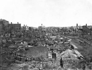
Looking east down Main Street after storm of April 5, 1861; Centre Street enters from the left at "Job Printing" and John C. Calef, dry goods shop is on the right. (Buck and Dunlap, p. 97).
Also filed under: Historic Photographs » // J. C. Calef Dry Goods »
Also filed under: Historic Photographs »
44 x 34 in.
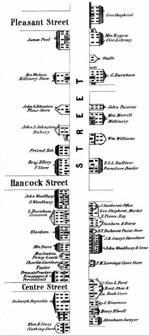
Henry Francis Walling, Map of the Towns of Gloucester and Rockport, Essex Co. Massachusetts. Philadelphia, A. Kollner, 1851
Cape Ann Museum Library & Archive
"Map of the Towns of Gloucester and Rockport, Massachusetts. H.F. Walling, Civil Engineer. John Hanson, Publisher. 1851. Population of Gloucester in 1850 7,805. Population of Rockport in 1850 3,213."
Also filed under: Maps » // Procter Brothers »
Oil on canvas
15 x 24 in.
Cape Ann Museum, Gloucester, Mass., Gift of Harold and Betty Bell, 1980 (2211)
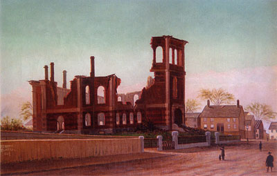
Also filed under: Elwell, D. Jerome » // Town House »
Cape Ann Museum Library & Archive
Also filed under: Historic Photographs »
Stereograph card
Cape Ann Museum Library & Archive
Also filed under: Historic Photographs » // Sawyer Free Library »
Cape Ann Museum Library & Archive
Also filed under: Gloucester Harbor, Inner / Harbor Cove » // Historic Photographs »
Stereograph card
Cape Ann Museum Library & Archive
From East Gloucester looking towards Gloucester.
Also filed under: Gloucester Harbor, Inner / Harbor Cove » // Historic Photographs »
Stereograph card
Cape Ann Museum Library & Archive
Also filed under: Half Moon Beach » // Historic Photographs » // Stage Rocks / Stage Fort / Stage Head » // Steepbank »
Stereograph card
Cape Ann Museum Library & Archive
Also filed under: Historic Photographs » // Stage Rocks / Stage Fort / Stage Head »
Cape Ann Museum Library & Archive
1775–1875 Gloucester's Centennial, August 9th. Stereoscopic views of the celebration.
Also filed under: Historic Photographs »
Stereograph card
Cape Ann Museum Library & Archive
"In the foreground is a clear sheet of water which washes upon the beach beyond. The Pavilion is quite prominent, while upon the rising background can be seen the steeples of the several churchs, the tower of the first Town House, and the Collins School House."
Also filed under: Historic Photographs » // Pavilion Hotel » // Stage Rocks / Stage Fort / Stage Head »
Stereograph card
Cape Ann Museum Library & Archive
"Bond's Hill is a high eminence on the west side of Gloucester Harbor. The foreground is very rocky and shows a portion of the old road to West Gloucester and Essex, used before the road was built across the marsh, which is to be seen in the center of the picture. Beyond the marsh road is the canal with its dyke. Then the ground rises and dwelling houses appear, till Lookout Hill (or Mount Vernon Street.) can be seen on the left of the background. On the right of the picture is the 'Cut' road, the only carriage entrance into the main part of the town. Beyond it is to be seen 'Crescent Beach,' with the Pavilion and 'old Fort' and a portion of East Gloucester in the background. In the centre of the picture can be seen the unfinished tower of the Town House, and in the distance is the open sea, with Thatcher's Island and its lighthouses just discernible."
Also filed under: Historic Photographs » // Pavilion Hotel »
Cape Ann Museum Library & Archive
View shows Main Street Fish Market, Gloucester, Mass.
Also filed under: Fishing » // Historic Photographs »
