An online project under the direction of the CAPE ANN MUSEUM
Catalogue Entry
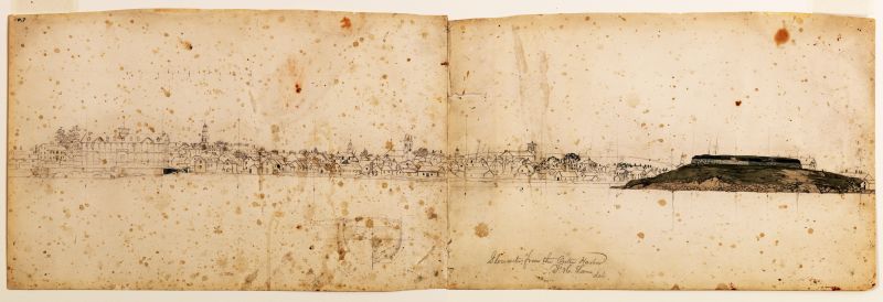
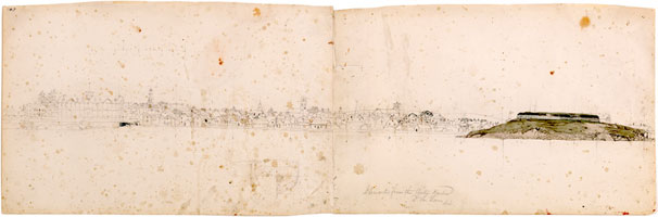
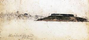
This drawing is a sketch for Lane's large painting Gloucester Harbor, 1852 (inv. 38) and includes a beautiful and detailed watercolor depiction of the Fort. The Fort's appearance is similar to what is seen in Watch House Point, 1860 (inv. 292). Frequently, Lane used more than one sheet of paper in order to accommodate long, horizontal compositions.
Gloucester from the Outer Harbor is typical in the great detail with which Lane represented the landscape and buildings, as well as in the lack of vessels. Apparently he was so confident in sketching boats that he did not need to include them in preparatory works. However, this sketch is interesting in that there is an unrelated drawing in the middle foreground. It shows the cross section of a ship from the stern, depicting the frames from the midship section to the stern compressed into a single plane.
To identify all of the buildings on the Gloucester skyline, please use the interactive feature for Gloucester Harbor, 1852 (inv. 38).
- Types of Objects
: - Study »
- Subject Types
: - Cape Ann Locales
: - Building Types
:
Historical Materials
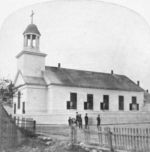
The old Baptist church appears in several Lane works. This was the first of three Baptist churches built on Pleasant Street. Baptists had been meeting on Cape Ann since 1808, originally in Sandy Bay (Rockport). But in 1830, a small group of Gloucester Baptists raised the funds to build a simple, unornamented, steeple-less white wooden building and chose this site near Franklin Square. Lane lithographs and paintings document the history of the building. In 1836, he showed it without a steeple. The building was improved in 1837 with the addition of a choir and the steeple, as seen in Lane's 1844 painting.
The building was not a church at the time of the painting of Gloucester Harbor in 1852, where it can be seen between the square four-spiked steeple of the First Parish Church and the mast of the closest, central boat. The Baptists, having recently built the large Italianate church seen just to the right in that 1852 painting, had sold the old Baptist church to Benjamin S. Corliss and other neighbors in 1850. Then in 1855, the Catholic community of Gloucester bought and moved the old church building around the corner to Prospect Street. The first Catholic mass had been held in 1849, in a private home, although the town hall was also available for masses. By 1855, the Catholic community established St. Ann's Parish, first in the old Baptist building (once again without a steeple, probably lost during the move from Pleasant Street), and then, when the current large stone church was built in 1876, this building became a school. It was replaced by the still-standing brick St. Ann's Parochial School in 1913.
– Sarah Dunlap (August, 2013)
Newspaper clipping
Cape Ann Advertiser
Collection of Fred and Stephanie Buck
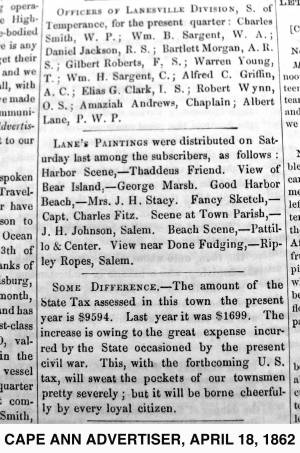
"LANE'S PAINTINGS were distributed on Saturday last among the subscribers, as follows: Harbor Scene, – Thaddeus Friend. View of Bear Island, – George Marsh. Good Harbor Beach, – Mrs. J. H. Stacy. Fancy Sketch, – Capt. Charles Fitz. Scene at Town Parish, – J. H. Johnson, Salem. Beach Scene, – Pattillo & Center. View near Done Fudging, – Ripley Ropes, Salem."
Also filed under: Alex Patillo Dry Goods » // Center & Co. » // Center, Henry » // Done Fudging » // Fitz, Capt. Charles » // Friend, Thaddeus » // Johnson, J. H. » // Marsh, George » // Newspaper / Journal Articles » // Patillo, Alex » // Ropes, Ripley » // Stacy, Mr. and Mrs. John Hancock »

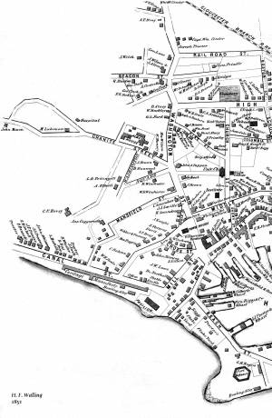
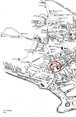
1851 44 x 34 in. Henry Francis Walling, Map of the Towns of Gloucester and Rockport, Essex Co. Massachusetts. Philadelphia, A. Kollner, 1851 Cape Ann Museum Library & Archive
"Map of the Towns of Gloucester and Rockport, Massachusetts. H.F. Walling, Civil Engineer. John Hanson, Printer. 1851. Population of Gloucester in 1850 7,805. Population of Rockport in 1850 3,213."
Also filed under: Burnham Brothers Marine Railway » // Duncan's Point » // Five Pound Island » // Flake Yard » // Gloucester Harbor, Inner / Harbor Cove » // Harbor Methodist Church (Prospect Street) » // Low (Frederick G.) wharves » // Pavilion Hotel » // Procter Brothers » // Ropewalk » // Vincent's Cove » // Western Shore »
Although in his 1852 Gloucester Harbor, Lane painted the Second Baptist Church to look like Italian brick, this building was in fact clad in New England clapboard, of an unknown but perhaps reddish color. It was the second Baptist church built in Gloucester, the first being just up Pleasant Street and visible in the same painting as the white steeple to the left. The second Baptist Church was designed by Gridley J.F. Bryant of Boston (the same architect who twenty years later would design Gloucester's City Hall) and was dedicated the year before, in March 1851. The minister at the time of the 1852 painting was Miles Sanford.
The church replaced a tavern on land directly across the street from Lane's childhood home. Lane never painted his old house, sold out of the family in 1839, but its location is often near the center of canvases of the harbor. In Gloucester Harbor, 1852 (inv. 38) painting at CAM, it was in the cluster of wooden houses partially covering the wall of the second Baptist church, to the right of the ship's mast. It was here that the young Nathaniel Rogers Lane played, ate the legendary and hypothetical "apple of Peru" to cause his lameness, learned the shoemaker's trade, and drew his early sketches of boats and sails. The site of the Lane house is now occupied by the old Gloucester Cooperative Bank building at 85 Middle Street.
This Baptist Church burned in December 1869, and was replaced in 1871 by the third Baptist church to stand on Pleasant Street, which in turn was torn down in 1966 to create a parking lot. But the large granite block used as its front step now forms the bottom of the pathway from the parking lot on Rogers Street up to the stone Fitz Henry Lane house.
Current address: Parking lot on Pleasant Street between Middle and Warren Streets, opposite the Cape Ann Museum.
– Sarah Dunlap (August, 2013)
44 x 34 in.
Henry Francis Walling, Map of the Towns of Gloucester and Rockport, Essex Co. Massachusetts. Philadelphia, A. Kollner, 1851
Cape Ann Museum Library & Archive
"Map of the Towns of Gloucester and Rockport, Massachusetts. H.F. Walling, Civil Engineer. John Hanson, Publisher. 1851. Population of Gloucester in 1850 7,805. Population of Rockport in 1850 3,213."
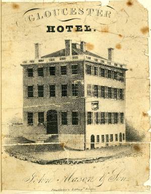
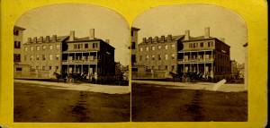
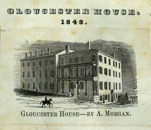
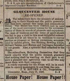
The Brick Houses were a cluster of buildings and a center of commerce and residence for wealthy local merchants. The brick hotel, the Gloucester House, was built by Col. James Tappan in 1810. It was four stories high, and scoffers of his grandiose hopes called it Tappan's Folly. It was from this hotel that stage coaches, before the 1847 extension of railroad to Gloucester, left for Boston every morning at 7:00 and returned every afternoon at 4:00. The hotel was opened year round, and was used by tourists and business people, as well as by local organizations. The John Mason family owned the hotel since the 1820s, and John's son Sidney Mason was the proprietor. Lane had perhaps already made an advertisement lithograph of this hotel in 1836. Sidney Mason also built the elaborate and luxurious summer Pavilion Hotel directly on the beach of the Outer Harbor. Both hotels are prominent in Gloucester Harbor, 1852 (inv. 38), and perhaps therefore the reason why Sidney commissioned Lane to paint that view. Col. Abijah Peabody, "one of the best landlords in the country," managed both hotels in 1852. Through the years, this brick hotel has also been named the Atlantic House, the Mason House, the Puritan House, and Blackburn Tavern. It still stands, offering a basement restaurant and upstairs public rooms.
The Gloucester House was the only brick building in the West End of town at the time of the disastrous fire on September 16, 1830, that wiped out blocks of wooden buildings and wharves. The brick buildings to the south and east of the Gloucester House replaced houses destroyed by that fire. Fire was an ever-present fear to Lane, who limped and walked with some difficulty. The story of the burning at sea of a merchant vessel on May 26, 1830, caught his attention, and the young artist, still Nathaniel Rogers Lane, painted Burning of the Packet Ship "Boston", 1830 (inv. 82) soon thereafter. A few months later, Lane, 26, lame and still living at home, experienced the panic and destruction of the September fire. His family's house on Middle Street was in danger, but survived intact. In 1849, after Lane returned to Gloucester from his lithography years in Boston, he built a fire-resistant stone house on Duncan's Point.
These brick houses were inhabited by wealthy merchants, owners of the wharves and businesses, next to the Town Landing and the intersection of Washington and Front Streets. Among them were Samuel Gilbert, James Mansfield, and Cyrus and Zachariah Stevens. Zachariah Stevens was the grandfather of Lane's friend and future executor, Joseph L. Stevens, Jr. Joseph lived with Zachariah from 1840 until his grandfather's death in 1846. Although still in Boston during this time, Lane frequently returned to his family and friends in Gloucester, and the two probably often met in the grandfather's house. Joseph and Lane made frequent trips to Joseph's parents' home in Castine, Maine.
Current address: West End of Main Street.
– Sarah Dunlap (August, 2013)
Cape Ann Museum Library & Archive
Stereo view
Also filed under: Historic Photographs »
Newsprint
Ad for Gloucester House
Courtesy of the American Antiquarian Society, Worcester, Mass.
See p. 4, column 2.
Also filed under: Newspaper / Journal Articles » // Party Boat »
In 1828, the Methodists built the Harbor Methodist Church towards the eastern end of Prospect Street. This was also called the "Church on the Rock," for they followed Matthew's advice and planted it firmly on a granite outcropping. Lane's mother, the widow Sarah Haskell Lane, and his brother Edward Lane were members in high standing of this congregation. In fact, Edward was on its Board of Trustees and served as a steward and a "class leader." Even after the Riverdale Methodist Meetinghouse was built in 1838, on Washington Street overlooking Mill River, and even after the Lanes had sold their house on Middle Street and moved to the old Whittemore house near Oak Grove Cemetery, Edward Lane and his mother continued to be members of the Harbor Methodist Society. Lane’s mother died in 1853, but when Lane painted the 1852 Gloucester Harbor, she and her son were still active members. The ministers in 1851 and 1852 were Rev. Jarvis Wilson and Rev. Linus Fish; there were about 115 members. This building was used as the Harbor's Methodist meetinghouse until 1858, when the society bought and moved into another meetinghouse on Elm Street and sold this building to George H. Rogers for $300.
It is probable that the church is the Prospect Street Church mentioned in a petition to the Selectmen of Gloucester in January 1859, by citizens who wished that the Town would buy and convert it into a schoolhouse. The building was still standing in 1876 but no longer exists.
Methodism began in Europe in 1738, came to New York City in 1760, and to Gloucester in 1806. The first meetings in town were in the house of John Edney on the eastern edge of the Mill Pond in the Town Parish (now Riverdale). In 1823, Rev. George Pickering arrived in town and meetings were held in the old first parish meetinghouse at the Green, near the White-Ellery House.
Current address: Southeast corner of Prospect and Taylor Streets.
– Sarah Dunlap (August, 2013)
1851 44 x 34 in. Henry Francis Walling, Map of the Towns of Gloucester and Rockport, Essex Co. Massachusetts. Philadelphia, A. Kollner, 1851 Cape Ann Museum Library & Archive
"Map of the Towns of Gloucester and Rockport, Massachusetts. H.F. Walling, Civil Engineer. John Hanson, Printer. 1851. Population of Gloucester in 1850 7,805. Population of Rockport in 1850 3,213."
Also filed under: Baptist Church (Old, First, 1830) (Pleasant Street) » // Burnham Brothers Marine Railway » // Duncan's Point » // Five Pound Island » // Flake Yard » // Gloucester Harbor, Inner / Harbor Cove » // Low (Frederick G.) wharves » // Pavilion Hotel » // Procter Brothers » // Ropewalk » // Vincent's Cove » // Western Shore »
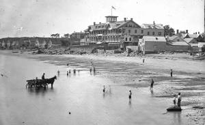
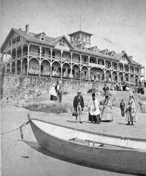
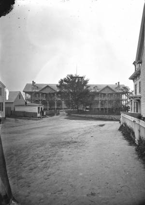
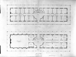
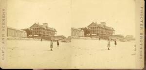
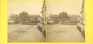
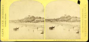
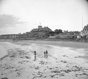
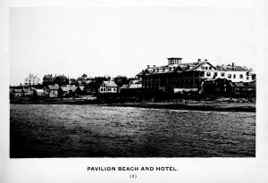
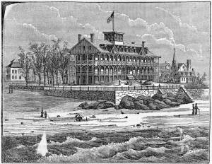
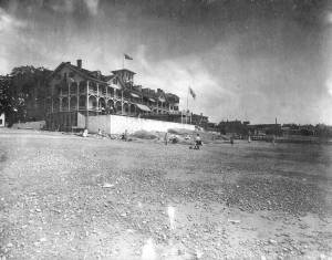
The Pavilion, built in 1849 for Sidney Mason, was Gloucester's first summer resort hotel. Mason was a patron of Lane, and he commissioned him to paint three views of scenes of his mercantile successes: New York Harbor, San Juan [Saint John] Harbor, and Gloucester Harbor, 1852 (inv. 38), in which the hotel, with all its porches, towers and tracery, is a prominent feature. Mason himself helped the architect S. Charles Bugbee design the building, that was then constructed by White and Winchester. A grist windmill, originally owned by Ignatius Webber and then by Sidney Mason's father, John Mason, had stood on the hill since 1814, but, in preparation for the Pavilion Hotel, was moved to the inner-harbor side of the old Fort and eventually burned in 1877. Both the windmill and the Fort can be seen in several Lane harbor paintings and drawings.
Sidney Mason lived in New York City at this time but was closely connected to his home town of Gloucester and owned another, traveler's hotel, the Gloucester House. But the Pavilion brought in an entirely new and different type of visitor to the fishing and trading town of Gloucester. The railroad from Boston had reached Salem in 1839 and Gloucester in November 1847. This not only led to Lane's return to Gloucester after his fifteen year residence in Boston, it also facilitated an influx of summer people. Before this time, a combination of stagecoaches, ferries, steamers and trains was needed to make the trip. Now, the wealthy from New York and Philadelphia could travel easily to Gloucester, as well as to other North Shore communities.
The hotel was not isolated from the business of the town. Next door to the west was one of the several long ropewalks in town. It was built by Ignatius Webber in 1803 and produced many of the miles of hemp rope and twine needed in the maritime trading and fishing trades. To the east, along the beach, were flake yards, where acres of split cod and other fish were laid out to dry in the sun. Lane did not include these in his painting. Nor is there any sign of tension between the tourist hotel and the local inhabitants and industries.
The Pavilion Hotel offered spectacular views and walks, both coastal and inland, and bathing was available all along the public beach that stretched to the Fort. The hotel itself was advertised as elegant, with luxurious sitting rooms, gas lighting and modern conveniences. Its first years were not entirely successful under the management of Dr. H.T. Haughey, once manager of Delaware's Brandywine Springs. But in 1852, Col. Abijah Peabody, manager of Mason's other hotel, the Gloucester House, took over the Pavilion and it flourished.
The Pavilion Hotel grounds were used during the Civil War as a recruiting office. It became the Surfside Hotel, and burned on Saturday, October 17, 1914. It was soon replaced by the Tavern, and that building still exists although no longer as a hotel and without the elegance and architectural flare of the original Pavilion.
Current address: 28–30 Western Avenue, The Tavern.
– Sarah Dunlap (September, 2013)
Stereograph card
Cape Ann Museum Library & Archive
Pavilion Hotel and the beach looking west from the Fort, Beach Court and Western Avenue.
Also filed under: Pavilion (Publick) Beach »
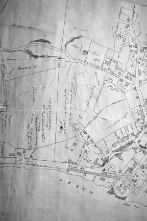
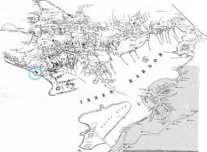
1834–35 Lithograph 24 x 38 in. Gloucester City Archives
"Drawn on a scale of one hundred feet to an inch. By John Mason 1834–45 from Actual Survey showing every Lott and building then standing on them giving the actual size of the buildings and width of the streets from the Canal to the head of the Harbour & part of Eastern point as farr as Smith's Cove and the Shore of the same with all the wharfs then in use. Gloucester Harbor 1834–1835."
This section of the map shows the location of the Pavilion Hotel and ropewalk along the beach.
Also filed under: Maps » // Mason, John » // Pavilion (Publick) Beach » // Ropewalk » // Windmill »
1851 44 x 34 in. Henry Francis Walling, Map of the Towns of Gloucester and Rockport, Essex Co. Massachusetts. Philadelphia, A. Kollner, 1851 Cape Ann Museum Library & Archive
"Map of the Towns of Gloucester and Rockport, Massachusetts. H.F. Walling, Civil Engineer. John Hanson, Printer. 1851. Population of Gloucester in 1850 7,805. Population of Rockport in 1850 3,213."
Also filed under: Baptist Church (Old, First, 1830) (Pleasant Street) » // Burnham Brothers Marine Railway » // Duncan's Point » // Five Pound Island » // Flake Yard » // Gloucester Harbor, Inner / Harbor Cove » // Harbor Methodist Church (Prospect Street) » // Low (Frederick G.) wharves » // Procter Brothers » // Ropewalk » // Vincent's Cove » // Western Shore »
Newspaper
Gloucester Telegraph p. 2 col. 2
Boston Public Library
Accession # G587
"Charlotte Cushman leaves for Europe today in steamship Asia, from New York,– She takes with her two of Lane's finest marine paintings, which she purchased on Monday."
Also filed under: Cushman, Charlotte » // Newspaper / Journal Articles »
1854 Newspaper "Letters on Art. - No. IV"
"In that space [four years] the town has grown greatly . . . a great ugly, yellow "Pavilion" suns itself on the rocks . . . I said there are only two stone buildings in this town of Gloucester: one is "the Bank," the other belongs to Mr. F. H. Lane, whose name ought to be known from Maine to Georgia as the best marine painter in the country.
If Mr. Lane is not as well known as he ought to be, he has at least no reason to complain of neglect or want of appreciation. He has been painting only fifteen years, and his pictures are in great demand; hitherto chiefly among sea-faring men, but now winning way in other circles. In former times I used to be often in Mr. Lane's painting-room, and it was with real pleasure that I found my way to his new house, built from his own design, of native granite, as I mentioned, handsome, peculiar, stable, and commanding a wide sweep of land and ocean from its ample windows. The house is the best that has been built in Gloucester for fifty years. . .
Mr. Lane has put few pictures in his studio at present; for he is very industrious, and sends his canvases off as fast as they are filled. If you were to meet him in the street, you would hardly take him for an artist. A man apparently of forty years, walking with difficulty, supported by crutches, hard-handed, browned by the sun and exposure, with a nose indicating less the artist sensibility than the artist resolution . . .
His early pictures had something in them too hard and practical to permit enthusiastic admiration; the water was salt, the ships sailed, the waves moved, but it was the sea before the Spirit of God moved upon the face of the deep.
His pictures early delighted sailors by their perfect truth. Lane knows the name and place of every rope on a vessel; he knows the construction, the anatomy, the expression – and to a seaman every thing that sails has expression and individuality . . . [Lane] has earned his money thus far mostly by painting "portraits" of vessels for sailors and ship-owners. It is owing to this necessity, perhaps, that he has fallen into the fault of too great literalness of treatment, which I have mentioned as characterizing some of his earlier works; but with the rapid advance he has made in the past four years, there is no longer any fear that he is incapable of treating a subject with genuine imagination . . .
He has indulged in no tricks and no vagaries; he has slighted nothing, despised nothing. If I appear to think less of his early pictures than they deserve, it is not because they are carefully even painfully studied, and because no detail has escaped his eye or brush; it is not that he has too much conscience; but simply because I missed in them the creative imagination of the artist. But it may well be a question whether at this day, when slight and untruthful work prevails, when artists will not paint with conscience, and the public does not strenuously demand it, conscience and love are not higher needs than imagination, and whether Mr. Lane's early pictures, the landmarks on his toilsome, earnest journey to his present place, have not a great value of their own. There is not one of them that I have seen, without some valuable passage, showing acute observation and careful, studious execution.
A sea-piece, "Off the coast of Maine, with Desert-Island in the distance," is the finest picture that Mr. Lane has yet painted. The time is sunset after a storm. The dun and purple clouds roll away to the south-west, the sun sinks in a glory of yellow light, flooding the sea with transparent splendor. Far away in the offing, hiding the sun, sails a brig fully rigged . . . I urged Mr. Lane to send this picture to New-York for exhibition . . ."
Also filed under: Newspaper / Journal Articles » // Residences »
Newsprint
Gloucester Telegraph
Cape Ann Museum Library & Archive
At a Sanitary Fair held at the Pavilion "obtained through the favor and generosity of the owner, Mr. SIDNEY MASON, of New York, and to whom many thanks are due." "... hangs a fine picture, the generous gift of our own Artist, Mr. Lane. The Subject is "Coffin's Beach," as seen from the "Loaf." This is the most costly article on sale in the rooms, and is valued at $100. It will be disposed of by tickets $1 each."
Two paintings by Lane, Little Good Harbor Beach and View from the Loaf were on sale at the Fair.
c.1870s Stereograph card Cape Ann Museum Library & Archive
Stereo view of the Pavilion from the southern or sea side.
Also filed under: Historic Photographs » // Pavilion (Publick) Beach »
Stereograph card Hervey Friend, Gloucester, Mass., Publisher Cape Ann Museum Library & Archive
Stereo view of the Pavilion Hotel from the street side.
Also filed under: Historic Photographs »
c.1890 Stereograph card Cape Ann Museum Library & Archive
"In the foreground is a clear sheet of water which washes upon the beach beyond. The Pavilion is quite prominent, while upon the rising background can be seen the steeples of the several churchs, the tower of the first Town House, and the Collins School House."
Also filed under: Gloucester – City Views » // Historic Photographs » // Stage Rocks / Stage Fort / Stage Head »
c.1880 Stereograph card Cape Ann Museum Library & Archive
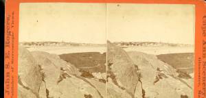
"Bond's Hill is a high eminence on the west side of Gloucester Harbor. The foreground is very rocky and shows a portion of the old road to West Gloucester and Essex, used before the road was built across the marsh, which is to be seen in the center of the picture. Beyond the marsh road is the canal with its dyke. Then the ground rises and dwelling houses appear, till Lookout Hill (or Mount Vernon Street.) can be seen on the left of the background. On the right of the picture is the 'Cut' road, the only carriage entrance into the main part of the town. Beyond it is to be seen 'Crescent Beach,' with the Pavilion and 'old Fort' and a portion of East Gloucester in the background. In the centre of the picture can be seen the unfinished tower of the Town House, and in the distance is the open sea, with Thatcher's Island and its lighthouses just discernible."
Also filed under: Gloucester – City Views » // Historic Photographs »
c.1870s Stereograph card Cape Ann Museum Library & Archive
Also filed under: Historic Photographs » // Pavilion (Publick) Beach »
c.1870s Stereograph card Cape Ann Museum Library & Archive
Also filed under: Historic Photographs » // Pavilion (Publick) Beach »
c.1870 Cape Ann Museum Library & Archive
Taken from Fort Point looking west. Ropewalk just to west of hotel.
Also filed under: Historic Photographs » // Pavilion (Publick) Beach » // Ropewalk »
c.1900.
Also filed under: Pavilion (Publick) Beach »
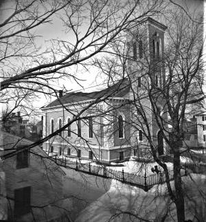
The Trinity Congregational Church, visible in Lane paintings such as Gloucester Harbor, 1852 (inv. 38), was built in 1831, during the time of the reconstruction of downtown Gloucester after the devastating 1830 fire. But this church was not built to replace one lost in that conflagration. It was built to house a large faction of the original First Parish Church (the four -pointed square tower visible in several paintings, just to the east on Middle Street) that was dismayed by the Unitarian drift of the parish. The rise of Unitarianism, and the hiring of new ministers with that leaning, caused those who continued to embrace the older Puritan, Calvinist, Congregational beliefs to secede and form their own church. It was a split between the more radical, newer element of the Unitarians and those who wished to maintain their older, Trinitarian roots.
The minister of the Trinitarian church in 1852 was James Aiken, who did not stay in town long. Nor did the building serve long as a church. In 1854, the building was sold, cut in half, and moved. Both halves now stand on Mason Street, facing south, across School Street from the Central Fire Station.
A second Trinity Congregational Church, with a steeple higher than any other in town, was immediately erected on same site in 1854. This 153-foot, octagonal steeple, visible in Gloucester from Steepbank, c.1855 (inv. 125) was removed in 1865. The church building was totally destroyed by fire in July 1979. A third church stands on the site today.
Current address: 70 Middle Street at the corner of School Street. However, the building that appears in pre-1854 Lane works was cut in half and moved to 2–8 Mason Street.
– Sarah Dunlap (August, 2013)
On Middle St., the building of the new Orthodox Church will soon be commenced. …we understand that the church when completed, will be the finest in the country. It is to be surmounted by a steeple higher than any other in town, and will be a prominent land mark. The contractors, Messrs. Smith & Babson, are young and enterprising mechanics, and will spare no pains to render the completion of the edifice as perfect and handsome as can be accomplished. The old church having been cut in two, and moved back on Mason Street, is being fitted up, and will be made into two large double dwelling houses. Another building has also been moved into this street and is being fitted up for a dwelling house.
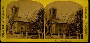
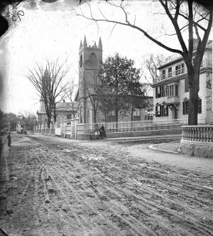
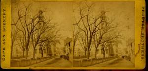
The First Parish (Unitarian) meeting house, located on Middle Street, was a wooden framed, clapboard-sheathed structure with a distinctive four-pointed neo-Gothic inspired tower. It was built in 1828, as the First Parish Church, replacing an earlier structure built on the site in 1738, when the "first" parish moved to the Harbor from its original location on the Annisquam River near where the Rte. 128 Grant Circle now is laid out. The parish system dated from the Massachusetts Bay Colony times, when both religious and civic business was conducted in the parish meetinghouses. This 1828 building was a descendant of that system. It became the Unitarian Church gradually in the 1830s, when more traditional members separated, formed their own society and built the Congregational/Trinitarian Church two doors to the west on Middle Street. The Universalists, Methodists, and Baptists had already seceded and formed their own congregations, and the parish system was at an end.
The Unitarian William Mountford, newly arrived from England, preached in this church from 1850 to 1853. In 1852, a new organ was dedicated on July 4, and Rev. Mountford was installed formally on August 3. (1) It is not known if Lane himself was a member of this or any church, but he shared several traits with Mountford: they both walked with a limp, and they were both interested in Spiritualism. Mountford moved to Boston in 1853 to pursue Transcendentalism and Spiritualism, and seldom returned to Gloucester. But he did come back in August, 1865, to officiate at Fitz Henry Lane's funeral, although Rev. Robert P. Rogers was minister at the time. It was from this church that Lane's body made its final journey to the Oak Grove Cemetery, where he was buried in the family plot of Joseph L. Stevens, Jr.
This building remained the Unitarian Church through the 1940s; however, the congregation had dwindled significantly and was no longer able to maintain the structure. The Gothic steeple was removed during this time. By 1950, the few remaining congregants were meeting with the Universalists further along Middle Street and the assets of the church were divided up: the church silver, made by Paul Revere, went to the Cape Ann Museum; endowment funds went to the Unitarian headquarters in Boston and the meeting house was sold to the local Jewish community who transformed it into Temple Ahavat Achim. Another victim of fire, it was destroyed in the conflagration that began in the next-door Lorraine Apartments on a wintry night of December, 2007.
Current Address: 86 Middle Street, site of Temple Ahavat Achim.
– Sarah Dunlap
Reference:
1. Babson, History of Gloucester, p. 497.
Watercolor on paper
Cape Ann Museum Library & Archive
Also filed under: Low (Frederick G.) wharves » // Maps »
c.1868 Glass plate negative
Also filed under: Lane's Stone House, Duncan's Point » // Residences »
Stereograph card Cape Ann Museum Library & Archive
Also filed under: Historic Photographs » // Procter Brothers »
44 x 34 in.
Henry Francis Walling, Map of the Towns of Gloucester and Rockport, Essex Co. Massachusetts. Philadelphia, A. Kollner, 1851
Cape Ann Museum Library & Archive
"Map of the Towns of Gloucester and Rockport, Massachusetts. H.F. Walling, Civil Engineer. John Hanson, Publisher. 1851. Population of Gloucester in 1850 7,805. Population of Rockport in 1850 3,213."
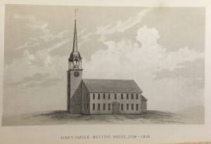
See p. 498. This shows the First Parish Meeting House before it was rebuilt in 1828.
Also filed under: Babson History of the Town of Gloucester »

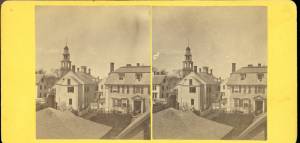
Stereograph card
Cape Ann Museum Library & Archive
View from top of Unitarian Church on Middle Street looking southeast, showing the Fort and Ten Pound Island. Tappan Block and Main Street buildings between Center and Hancock in foreground.
Also filed under: Fort (The) and Fort Point » // Ten Pound Island »
Cape Ann Museum Library & Archive
Middle Street looking west. At the corner of Dale Avenue is the Sanders-Davidson house, later Sawyer Free Library. Also shown: Unitarian Church, Congregational Church.
Also filed under: Sanders-Davidson House »
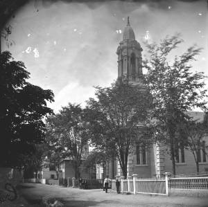
This large steepled building is Gloucester's Universalist Church. Universalism had found fertile ground here in Gloucester before the Revolution under the leadership of John Murray, who brought the teachings of James Relly from England in 1774. With adherents among the town's leaders such as Winthrop Sargent and his daughter, Judith Sargent Stevens Murray, it spread and flourished. The Gloucester adherents to Universalism refused to support quasi-governmental parish churches, specifically the First Parish in the Harbor district, and, speaking as well for all other non-parish churches, their dissent led to the Constitutional separation of Church and State. The first Universalist meetings were held on Sargent property at what was then Spring and Water Streets, now near the corner of Main and Duncan Streets. In 1805, under a new minister, Thomas Jones, this towering structure of the Universalist Church was erected by the local architect and builder, Jacob Smith.
The church's interior and foundation have been changed slightly since Lane's 1852 painting: in the 1860s, the foundation was raised seven feet to allow for a hall in the basement, and the lovely curved vestry staircases were installed. But the steeple remains as Smith, and Lane, saw it. It still houses a Paul Revere bell—for many years the only large bell in town. In 1852, this was the tallest structure on the skyline and a beacon to returning vessels. Its height was increased by the addition of a 'blind story' to the stack of belfry, lantern and cupola.
In 1852, the minister of the church was Amory D. Mayo, but in three years William R.G. Mellen would occupy the pulpit. He and his brother Charles Mellen were both Universalist ministers. Charles' wife was Mary Blood Mellen, Lane's student and copyist, but Charles was never a minister in Gloucester.
Current address: 50 Middle Street.
– Sarah Dunlap (May, 2014)
Cape Ann Museum Library & Archive
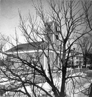
Stereo view of a front and side view of the Church, taken when there was no foliage upon the trees. Church street is also given throughout its length.
Also filed under: Historic Photographs »
1865 Stereograph card Cape Ann Museum Library & Archive
Also filed under: Historic Photographs »
44 x 34 in.
Henry Francis Walling, Map of the Towns of Gloucester and Rockport, Essex Co. Massachusetts. Philadelphia, A. Kollner, 1851
Cape Ann Museum Library & Archive
"Map of the Towns of Gloucester and Rockport, Massachusetts. H.F. Walling, Civil Engineer. John Hanson, Publisher. 1851. Population of Gloucester in 1850 7,805. Population of Rockport in 1850 3,213."

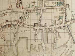
1834–35 24 x 38 in. Gloucester City Archives
"Drawn on a scale of one hundred feet to an inch. By John Mason 1834–45 from Actual Survey showing every Lott and building then standing on them giving the actual size of the buildings and width of the streets from the Canal to the head of the Harbour & part of Eastern point as farr as Smith's Cove and the Shore of the same with all the wharfs then in use. Gloucester Harbor 1834–35."
This map is especially helpful in showing the wharves of the inner harbor at the foot of Washington Street.
Also filed under: Dale, Eben B. » // Eastern Railroad » // Flake Yard » // Gloucester Harbor, Inner / Harbor Cove » // Hough, Benjamin Kent » // Maps » // Pavilion (Publick) Beach » // Ropewalk » // Sawyer, Samuel » // Town / Public Landings »

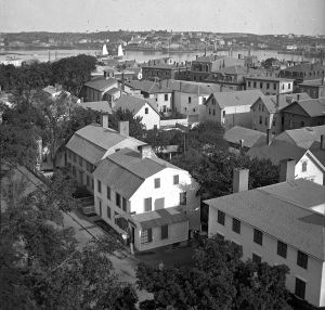
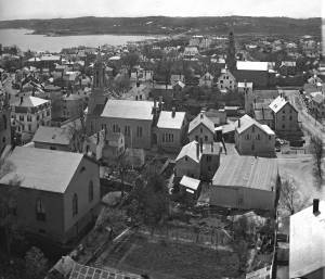
4 x 6 in.
Cape Ann Museum, Benham Collection
George Steele sail loft, William Jones spar yard, visible across harbor. Photograph is taken from high point on the Fort, overlooking business buildings on the Harbor Cove side.
Also filed under: Fort (The) and Fort Point » // Gloucester Harbor, Inner / Harbor Cove » // Town House » // Waterfront, Gloucester »
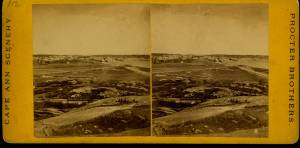
Through the years, this point and its fortifications had many names: Watch House Point, the Old Battery, Fort Defiance, Fort Head, and now just "The Fort." In 1793, Fort Defiance was turned over to the young United States government and was allowed to deteriorate. During the War of 1812 it was described as being "in ruins," and any remaining buildings burned in 1833. It was resuscitated in the Civil War and two batteries of guns were installed. The City of Gloucester did not regain ownership of the land until 1925.
The first fortifications on this point, guarding the entrance to the Inner Harbor, were put up in the 1740s, when fear of attack from the French led to the construction of a battery armed with twelve-pounder guns. Greater breastworks were thrown up in 1775, after Capt. Lindsay and his sloop-of-war the "Falcon" attacked the unprepared town. They were small and housed only a few cannon and local soldiers. Several other fortifications were at various times erected around the harbor: Fort Conant at what is now Stage Fort Park, another on Duncan's Point (near site of Lane's house) and the Civil War fort on Eastern Point. None of these preparations was ever called upon to actually defend the town.
Lane during his lifetime created a long series of images of the point and the condition of its fortifications. In 1832 there were still buildings standing, and the point had not yet been used for major wharves and warehouses. By the time of his painting Gloucester Harbor, 1852 (inv. 38), one can see that the earthwork foundation, but no superstructures, survived.
– Sarah Dunlap

1860 In John J. Babson, History of the Town Gloucester (Gloucester, MA: Procter Brothers, 1860) Cape Ann Museum Library & Archives, Gloucester, Mass.
See p. 474.
View related catalogue entries (4) »
Also filed under: Babson History of the Town of Gloucester » // Chebacco Boat / Dogbody / Pinky » // Gloucester Harbor, Inner / Harbor Cove » // Gloucester, Mass. - "Ten Pound Island Light » // Schooner (Coasting / Lumber / Topsail / Packet / Marsh Hay) » // Ten Pound Island »
Newsprint
Gloucester Telegraph
About picture of Old Fort hanging in the Gloucester Bank: "This picture is chiefly of interest on account of its preserving so accurately the features of a view so familiar to many of our citizens and which can never exist in reality."
Also filed under: Chronology » // Gloucester Bank » // Gloucester, Mass. – Gloucester Bank » // Newspaper / Journal Articles »

24 x 38 in.
Gloucester City Archives
"Drawn on a scale of one hundred feet to an inch. By John Mason 1834–45 from Actual Survey showing every Lott and building then standing on them giving the actual size of the buildings and width of the streets from the Canal to the head of the Harbour & part of Eastern point as farr as Smith's Cove and the Shore of the same with all the wharfs then in use. Gloucester Harbor 1834–35."
This map is especially useful in showing the Fort.
Also filed under: Flake Yard » // Maps » // Mason, John » // Pavilion (Publick) Beach » // Town / Public Landings »

44 x 34 in.
John Hanson, Publisher
Cape Ann Museum Library & Archive
"Map of the Towns of Gloucester and Rockport, Massachusetts. H.F. Walling, Civil Engineer. John Hanson, Publisher. 1851. Population of Gloucester in 1850 7,805. Population of Rockport in 1850 3,213."
Also filed under: Low (Frederick G.) wharves » // Maps » // Rogers's (George H.) wharves » // Town / Public Landings » // Waterfront, Gloucester » // Windmill »
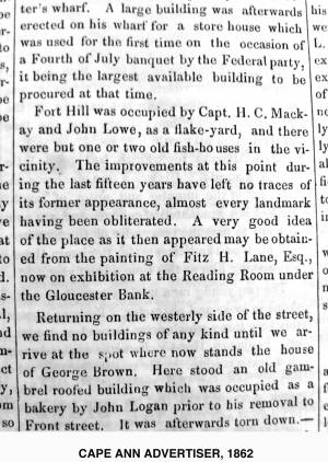
Newsprint
Cape Ann Advertiser
Cape Ann Museum Library & Archive
"Fort Hill was occupied by Capt. H. C. Mackay and John Lowe, as a flake-yard, and there were but one or two old fish-houses in the vicinity. The improvements at this point during the last fifteen years have left no traces of its former appearance, almost every landmark having been obliterated. A very good idea of the place as it then appeared may be obtained from the painting of Fitz H. Lane, Esq., now on exhibition at the Reading Room under the Gloucester Bank."
Also filed under: Gloucester Bank » // Newspaper / Journal Articles »
Newspaper
Gloucester Telegraph
"By the will of the late Fitz H. Lane, Esq., his handsome painting of the Old Fort, Ten Pound Island, etc., now on exhibition at the rooms of the Gloucester Maritime Insurance Co., was given to the town... It will occupy its present position until the town has a suitable place to receive it."
Also filed under: Funeral & Burial » // Gloucester, Mass. – Marine Insurance Company » // Newspaper / Journal Articles » // Ten Pound Island »
Newsprint
Gloucester Telegraph
At the dedication of the Town House, speaker, "read the following letter:
To the Selectmen of Gloucester: / Gents: The will of our late Townsman, Fitz. H. Lane, contains this provision: / I give to the inhabitants of the Town of Gloucester, the picture of the Old Fort, to be kept as a memento[sic] of one of the localities of olden time; the said picture now hanging in the Reading Room under the Gloucester Bank, and to be there kept until the Town of Gloucester shall furnish a suitable and safe place to hang it. / The original sketch was taken twenty-five years ago, but the boats and vessels introduced are those of a quarter of a century earlier still. The painting was executed in 1859, six years before his decease."
Also filed under: Documents / Objects » // Newspaper / Journal Articles » // Town House »
Stereograph card
Cape Ann Museum Library & Archive
View from top of Unitarian Church on Middle Street looking southeast, showing the Fort and Ten Pound Island. Tappan Block and Main Street buildings between Center and Hancock in foreground.
Also filed under: Ten Pound Island » // Unitarian Church / First Parish Church (Middle Street) »

1876 Photograph Cape Ann Museum Library & Archive
Ignatius Weber's windmill (now defunct) is shown.
Also filed under: Flake Yard » // Gloucester Harbor, Inner / Harbor Cove » // Historic Photographs » // Rogers's (George H.) wharves » // Schooner (Fishing) » // Waterfront, Gloucester » // Windmill »
Packet shipping was conducted by vessels of many types in many regions over the last four centuries, but the packets depicted by Lane were the products of nineteenth-century mercantilism and the Industrial Revolution. The packets sailing out of Boston and New York for European ports were large vessels, invariably ship-rigged, and if not as sharp-ended as clipper ships, had sufficiently fine hull forms to make fast, if not record, passages.
A packet ship's highest priority was delivery of mail on a regular schedule. Passengers and high-value trade goods occupied the considerable remaining hold space. This was particularly true of west-bound passages, which brought fine European wares and throngs of immigrants to America. East-bound passages brought professionals, students, travelers, and high-value raw and semi-finished materials to European ports, mainly Britain and France, and to a lesser extent, the Netherlands and Germany.
East-bound cargos were dominated by southern products - baled cotton, rice, tobacco, and naval stores. These were delivered to New York and other northern ports by coastal packets (mainly brigs and small ships) for transatlantic shipment. Northern products included flaxseed, iron ore, fruit, wool, hides, and flour. Delivery times were on average well within 30 days, giving credence to the packet lines' promise of scheduled delivery.
West-bound passages, which meant sailing against the wind, took longer—34 to 40 days on average, depending on the port of departure. Cargos and passengers were a far more varied lot with little of the consistency of east-bound counterparts.
Lane's paintings depict Boston and New York packet ships in the peak years of their employment. The Civil War, coupled with the development of reliable steam engines for marine propulsion, posed challenges the sailing ship could not overcome. Coastal packet lines went quickly, the transatlantic lines lasting into the 1870s.
– Erik Ronnberg
Reference:
Robert G. Albion, Square-Riggers on Schedule (Princeton, NJ: Princeton University Press, 1938).
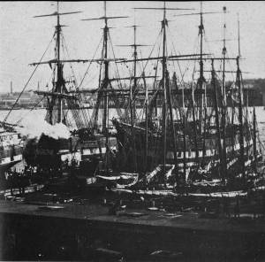
Photograph
Johnson, H. and Lightfoot, F.S.: Maritime New York in Nineteenth-Century Photographs, Dover Publications, Inc., New York
Also filed under: New York Harbor »

Oil on canvas
24 x 35 in.
Peabody Essex Museum, Salem, Mass.
Walters' painting depicts the "Nonantum" homeward bound for Boston from Liverpool in 1842. The paddle-steamer is one of the four Clyde-built Britannia-class vessels, of which one is visible crossing in the opposite direction.
View related catalogue entries (2) »
Also filed under: Ship (Full-Rigged) » // Walters, Samuel »
Marks: Inscribed upper left (in black ink): 103 [numbering system used by curator A. M. Brooks upon Samuel H. Mansfield's donation of the drawings to the Cape Ann Museum]