An online project under the direction of the CAPE ANN MUSEUM
Catalogue Entry
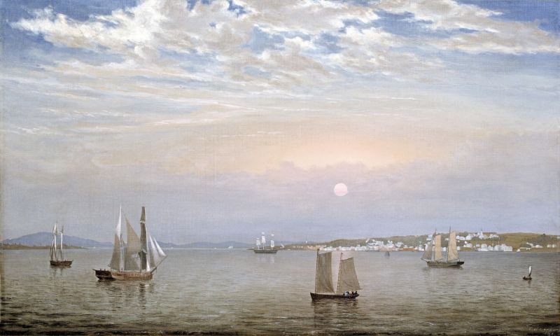
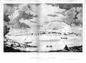
This scene was painted in 1851 for Noah Brooks of Castine from a plein air pencil drawing Castine Harbor and Town, 1851 (inv. 277), which was probably finished indoors in watercolor. We see Castine and its harbor from Hainey’s Point, just north of Henry’s Point on the east bank of the Bagaduce River, looking west toward the northwest side of Penobscot Bay. For the painting, Lane omitted the land in the drawing’s foreground, leaving the harbor and distant background terrain to give a sense of place. It is evening and a late summer sun glows through a thin overcast of stratus clouds as a warm front approaches.
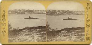
The foreground excepted, the depiction of the setting is identical in both the sketch and the painting. The right side includes the most heavily settled part of Castine, with houses lining the shore, ending a half mile before reaching Dice’s Head with its lighthouse. At left is part of Nautilus Island, while beyond and extending across the harbor’s entrance lies North Isleboro. In the far distance (more easily distinguished in the watercolor), lie the hills of Penobscot Bay’s western shore. Within the harbor, to the right, is a pyramidal stone structure called a monument, located to mark the presence of shallows called Middle Ground. There is no indication of such a marker in the charts and sailing directions of the U.S. Coast Survey published in the early years of its work in this region (1860s and 70s).
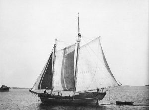
The vessels portrayed are dwarfed by their surroundings, and the ones in the foreground are smaller examples of their rigs and hull types—local working craft and strictly utilitarian in form, finish, and use. At far left is a topsail schooner; next, a lumber brig (half-brig rig). In center foreground is a New England boat, normally used for fishing, but here with a party on board, either out for a pleasant cruise around the harbor or on their way to visit friends or relatives.
Astern of them is a coasting schooner with what looks like a deck load of firewood logs, or more likely, kiln wood for Castine’s busy lime kilns. At extreme right is a small boat—possibly a yawl boat—fitted for sailing.
Further down the harbor is a large merchant ship coming to anchor and taking in sail. Castine’s participation in the foreign trade arose out of her shipbuilding activity, leading from shipping a variety of goods and materials to becoming the most important importer of salt for Maine’s fishing industry. This led in turn to manufacturing fish netting and other fishing gear and being a major source of these materials for fishermen in the northern bay region.
Lane’s visits to Castine came at the high point of that town’s maritime enterprise. With the Civil War and postwar decline of Maine’s deep-water trade and fishing industry, the port faced a grim future, which was narrowly avoided by a blossoming tourist industry. Life in Castine—as in the rest of Penobscot Bay—was to go on in a very different way.
– Erik Ronnberg
Historical Materials
Wilson Museum, Castine, Maine
Filed under: Brooks, Noah » // Historic Photographs »
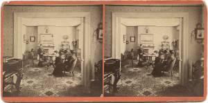
Wilson Museum, Castine, Maine
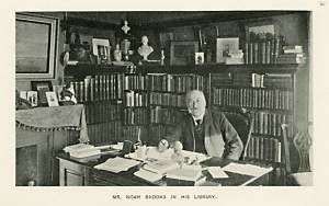
This photo shows Lane's painting Castine Harbor and Town hanging on the wall of Brooks's library in his home in Castine.
Filed under: Brooks, Noah » // Historic Photographs »
The Camden Mountains, also called the Camden Hills, are located just northeast of the town of Camden. The range includes Mount Megunticook, upon whose shoulders Mount Battie sits, Cameron Mountain, and Bald Rock Mountain. They stand high above West Penobscot Bay between Camden and Lincolnville, looking east toward Mount Desert and the rising sun. The Wabenaki, loosely defined as the "people of the dawn," greeted their maritime world, "the dawn land," from the Camden Hills, and other high points, including Mount Wallamatogus in Penobscot (460 feet), Awan-adjo (at Bluehill), Caterpillar Hill in Sedgwick (with its panoramic sweep which stretches from the Camden Hills to Mount Desert and far out into Penobscot Bay), and atop Cadillac Mountain, Mount Desert. It is from the same peaks that artists and pilgrims alike still climb to view Penobscot Bay.
Mad-kam-ig-os'-sek, "big high land," is the Wabenaki word for Camden, and Meg-un-ti-cook, "big mountain harbor," the name for the harbor, is now used for Mount Megunticook. The inner harbor, quiet and safe, would have been the ideal place for a large, oceangoing canoe to lay up when the sea was rough. Capt. John Smith visited this place in 1614, during the Beaver Wars, and noted that the high mountains were used as a refuge from the Mik'maq of the Maritimes who fought the Wabenaki of Penobscot Bay to maintain their place as middlemen in the fur trade. These raiders would travel along the Downeast coast in their shallops. Mount Battie, of many spellings, was noted as Mount Betty in documents dating from 1757. It is a European corruption of a word borrowed from another place, the Madambettox Hills of Rockland.
-Mark Honey
References:
Eckstorm, Fannie Hardy, "Indian Place-Names of the Penobscot Valley and the Maine Coast," University of Maine Studies, 2nd Series, #55, November 1941, reprinted 1960 by the University of Maine Press. DeLorme's Atlas. Frank G Speck's "Penobscot Man," University Of Pennsylvania Press, 1940.
Newsprint
Gloucester Telegraph
"The Reef of Norman's Woe ... is now commemorated in painting too, one of the finest pictures from Lane's easel. ... The sketch was made at the pretty spot commonly called, we believe, Master Moore's Cove. Being some little way off the main track to Rafe's Chasm, it is seldom visited, except by the more inquisitive lovers of nature who leave the beaten road to pry out such pleasant places. ... We wish it might find a home buyer, rather than go off to enrich another community." Flowery description follows, then "There is another and larger work in the artist's studio, which, happily, is to be retained. It received much well deserved notice and commendation. The subject is a view southward from the 'Cut,' with the picturesque promontory commonly known as 'Stage Fort,' and historically interesting as the supposed spot of the 'Landing at Cape Ann' in the middle distance, and Eastern Point on the extreme left." More description follows, "Among other attractions of the studio, and particularly worthy of mention, is a cabinet picture with an effect similar to the Norman's Woe. The subject is chosen from the many sketches of the grand scenery of the Maine sea-coast with which the artist's portfolio is rich. It is a view of the Camden mountains sketches from the Graves, a jagged ledge far out in the bay, which is accessible in only the smoothest water."
Also filed under: Cut, The (Stacy Blvd.) » // Newspaper / Journal Articles » // The Graves »
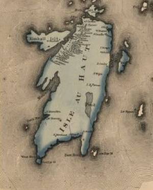
Castine is a town located on a sheltered harbor in Maine's Penobscot Bay. According to the Maine Register of 1850 it had a population of 1260.
Castine, as the seat of customs, registered 31.4% of Maine's sea fisheries tonnage in 1850. Castine's merchants serviced the needs of Penobscot Bay's fishermen, fitting up supplies and salt, and offering both employment and opportunities for investment in the cod fisheries. Beginning about 1824 Castine fitted out at least 300 vessels with more than two thousand men in a year. (1) Castine's shipyards built both fishing schooners and large ships, ships which carried cotton from New Orleans to the cotton mills of Great Britain, and returned with salt from Liverpool and Cadiz. Castine was at the height of its economic power in the 1850s, the commercial hub for the broader community of Penobscot Bay. (2)
In Gloucester, some aspects of the fishing industry were changing. The fishing vessels of Penobscot Bay tended to be smaller in size, more democratic in ownership, and more intimate with regard to crew, who were more often than not members of an extended family or from the same communities.
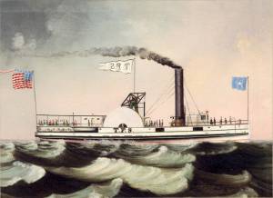
The steamboat lines began connecting Maine to Boston in 1824. In 1845 Captain Sanford's Independent Line tried his "Penobscot I" on the route that would become standard, an overnight route to Boston. He also initiated in 1846 "the Blue Hill line" which used the 130-foot "T. F.Secor" to connect with the Boston boat at Belfast and run up to Bangor and as far east as Blue Hill with landings both ways. During the 1850s steamers became larger and more luxurious, with competing steamer lines, and steamships also used in the lumber trade. (3)
References:
1.W.H. Bunting, A Day's Work: A Sampler of Historic Maine Photographs (Portland, ME: Maine Preservation), p.56.
2. Roger F. Duncan, "Coastal Maine, A Maritime History," WW Norton & Company, New York, 1992. Mark Honey, "King Pine, Queen Spruce, Jack Tar," An Intimate History of Lumbering on the Union River, Volumes 1-5. This source, in its entirety, lays down the foundation of Downeast Maine's unique culture which was built upon pine lumber and timber, the cod fisheries, coasting, shipbuilding, and the interrelationships of family and community.
3. Allie Ryan, Penobscot Bay Mount Desert, and Eastport Steamboat Album (Camden, ME: Downeast Magazine, 1972).
Honey, Mark E, "Abigail & Sarah Hawes of Castine," Navigators & Educators, with Lois Moore Cyr, 1996.
Honey, Mark E, "Before the Mast," Volume IV, articles 7-9, Holbrook Island and the Holbrook family, and in particular, Robert Applebee, "Vessels of the Penobscot Customs District," Stephan Phillips Memorial Library, Penobscot Marine Museum, Searsport, which source also has the diaries of Capt. Jonathan Holbrook and the genealogy of the Holbrook family in the Priscilla Jones collection. The "Before the Mass" series can be found in the collections of the Castine Historical Society and the Wilson Museum, both in Castine.
McLane, Charles B, and McLane, Carol Evarts, "Islands of the Mid-Maine Coast," Penobscot Bay, Volume 1, Revised Edition, Tilbury House, Publishers, Gardiner, Maine, and the Island Institute, Rockland, Maine.
McLane, Charles B, and McLane, Carol Evarts, "Islands of the Mid-Maine Coast," Mount Desert to Machias Bay, Volume 2, The Kennebec River club Press, Incorporated, Falmouth, 1989.
O'Leary, Wayne M, "Maine Sea Fisheries," The Rise and Fall of a Native Industry, 1830-1890, Northeastern University Press, Boston, 1996, pages 350-351, for the percentage of sea fisheries in 1850.
Personal journal
Wilson Museum, Castine, Maine
Box 2, F1 (A00772)
John Stevens was the younger brother of Joseph Stevens, and acquainted with Lane, spending time with him in Gloucester and at the family home in Castine. His journal, quoted below, includes reference to hunting plover and teal, school, sailing, local events. Mentions Castine mill, lighthouse, and block house.
"Friday [September] 17th: Cloudy all day. Wind N. blowing quite hard. A British Rig loaded with salt from Liverpool came into port last night. She run way up by the Monument and got aground. They kedged her off this P.M. and came down. She came in with one of these old English charts as her guide. They have the town set down on the Brooksville side, two miles + three quarters from the lighthouse."
"Wednesday [September] 22. . .Went down to the Indians Camp on the Back Cove. There were five camps of them."
Visits Gloucester from Castine:
"Wednesday [October] 27th. . .Left for Gloucester [from Boston] at 5 o'clock this P.M. arrived there safe + sound at 6 1/2 o'clock; went right down to the store and saw Joe. We then went up to his house and got supper.
"Thursday [October] 28th. At. Gloucester. Pleasant day. Went down to the "Cut" a gunning this morning before breakfast but saw no birds. Went out in the harbor this forenoon alone, had a fine sail but couldn't get a chance at any birds. Went out again this P.M. got down to East Point Light and the wind died all away, so I had to scull home."
"Friday 29th. Very pleasant day, went out in the harbor this morning with Joe. Took a walk this A.M. with "Lina", called on Mr. Lane + Doct. Hildreth. Joe + I went out in the harbor this P.M. I fired at some birds several times, but didn't get any. . . ."
Also filed under: Biographical information » // Bird Hunting » // Castine – School » // Chronology » // Cut, The (Stacy Blvd.) » // Diaries / Ledgers / Etc. » // Stevens, Joseph, Jr. »
Newspaper
"Mr. F. H. Lane of Gloucester . . .visits here nearly every summer"
Also filed under: Chronology » // Newspaper / Journal Articles »
Personal diary
Castine Historical Society
From July 25-August 16,1848, Castine native Noah Brooks made a return visit to his hometown. He was eighteen at the time, and had been living in Boston. In his diary, there is no mention of Lane, but he recounts Castine gossip, and writes about visits with the Stevens and Witherle familes, accounts of swimming in Back Cove, and reading Wuthering Heights. The daily arrival of "the boat" (the "T.F.S." or the "Secor")—the way it was anticipated and observed by Castine residents—is notable.
Also filed under: "T. F. Secor" (Steamboat) » // Brooks, Noah » // Diaries / Ledgers / Etc. » // Steamers » // Stevens, Joseph, Sr. and Dorothy Little » // Witherle, William Howe »
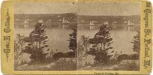
Stereograph card Castine Historical Society Collections (1996.1)
Also filed under: Historic Photographs »
Stereograph card Castine Historical Society Collections (1998.34)
Also filed under: Historic Photographs »
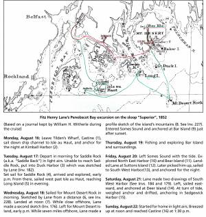
Chart
U.S. Coast Survey
Chart with key showing the route of an excursion on the sloop "Superior" out of Castine made by William H. Witherle, Lane, Stevens and friends during which Lane made several sketches of Mt. Desert scenery. The trip was chronicled by Witherle in his diary of 1852.
Handwritten list
Wilson Museum, Castine, Maine (A00787-1a-1d)
Also filed under: Castine – Witherle & Co.'s Store » // Lithography (Sales & Exhibitions) » // Noyes, Samuel » // Publications » // Stevens, Joseph, Jr. » // Witherle, William Howe »
Stereograph card Castine Historical Society Collections (1996.1)
Also filed under: Castine, Maine – Dice (Dyce) Head Lighthouse » // Historic Photographs »
Photograph
In The Illustrated Coast Pilot with sailing directions. The Coast of New England from New York to Eastport, Maine including Bays and Harbors, published by N. L. Stebbins, Boston, Mass.
Also filed under: Castine, Maine – Dice (Dyce) Head Lighthouse »
Letter
Cape Ann Museum, Gloucester, Mass.
Also filed under: "General Gates" (New England Boat; Casco Bay Boat) » // Chronology » // Letters » // Stevens, Joseph, Sr. and Dorothy Little »
1903 Four-page letter Collection of the Cape Ann Museum Library & Archive, Gloucester, Mass.
"[The painting] is offered you for $150 on as long time and in as many notes at 3% interest as you choose. . . I believe this to be the only important painting of Gloucester Harbor that Lane never duplicated. . . .Returning from a Gloucester visit while I was still under the roof there, father brought a print of Lane's first Gloucester view, bought of the artist at his Tremont Temple studio in Boston. An extra dollar had been paid for coloring it. For a few years it was a home delight.. . .I had been a few years in Gloucester when Lane began to come, for part of the time a while, if I remember rightly. He painted in his brother's house, "up in town" it then was. I recall visits there to see his pictures. But it was long after, that I could claim more than a simple speaking acquaintance. The Stacys were very kind, aiding him as time went on in selling paintings by lot. I invested in a view of Gloucester from Rocky Neck, thus put on sale at the old reading room, irreverently called "Wisdom Hall." And they bought direct of him to some extent, before other residents. Lane was much my senior and yet we gradually drifted together. Our earliest approach to friendship was after his abode began in Elm Street as an occupant of the old Prentiss [sic-corrected Stacy] house, moved there from Pleasant. I was a frequenter of this studio to a considerable extent, yet little compared with my intimacy at the next and last in the new stone house on the hill. Lane's art books and magazines were always at my service and a great inspiration and delight—notably the London Art Journal to which he long subscribed. I have here a little story to tell you. A Castine man came to Gloucester on business that brought the passing of $60 through my hands at 2 1/2 % commission. I bought with the $1.50 thus earned Ruskin's Modern Painters, my first purchase of an artbook. I dare say no other copy was then owned in town. . . .Lane was frequently in Boston, his sales agent being Balch who was at the head of his guild in those days. So in my Boston visits – I was led to Balch's fairly often – the resort of many artists and the depot of their works. Thus through, Lane in various ways I was long in touch with the art world, not only of New England but of New York and Philadelphia. I knew of most picture exhibits and saw many. The coming of the Dusseldorf Gallery to Boston was an event to fix itself in one's memory for all time. What talks of all these things Lane and I had in his studio and by my fireside!
For a long series of years I knew nearly every painting he made. I was with him on several trips to the Maine coast where he did much sketching, and sometimes was was [sic] his chooser of spots and bearer of materials when he sketched in the home neighborhood. Thus there are many paintings whose growth I saw both from brush and pencil. For his physical infirmity prevented his becoming an out-door colorist."
Single sheet, writing both sides
Cape Ann Museum Library & Archives, Gloucester, Mass.
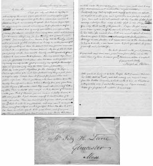
"My dear Sir,
I hope you will not attribute the delay in acknowledging the receipt of your splendid, and most unexpected Gift to a want of a due appreciation of it. Many reasons have consipired to prevent my doing it – unnecessary to repeat. But I can no longer defer the expressions of our warmest acknowledgements for a present in itself so valuable, and endeared to us by many associations, as a representation of scenery often admired, and which I have many times wished could be transferred to canvas, although vary far from thinking that wish would ever be gratified. You must premit me, however, to say that the Painting, valuable as it is as a work of Art, and pleased as I may be as the possessor of it, is less appreciated by us than the delicate and very generous manner in which its acceptance has been tendered. My love of Art, to which you do politely allude, I am sensible has only wanted opportunity of indulgence to have amounted to a passion. From my earliest days I have wished for opportunities to visit places, where that desire could be gratified, and my reading has only had the effect of increasing my regrets for the want of them, and of encouraging envy for those more fortunate - I feel, too, under great obligations for the Drawing of the "Siege"(1) – I had no expectations you could have produced anything so good from so rough a copy. I shall have it framed for presentation and future reference. Several gentlemen who have called in to see the painting have expressed a desire to have a drawing from you of our town, similar to yours of Gloucester, which they much admire, and of lithographs, I have no doubts copies enough could be disposed of to remunerate you. That of Homans you are aware is feebly drawn, & still worse printed. I feel desirous myself it should be done, if it suits your wishes. There are several points of view, which you did not see, & to which it will be my pleasure, next summer, to carry you. I know many of our citizens would be gratified to have this done by you. Our house we shall expect to be your home, and if, as you suggested in Gloucester, you should come in your Boat, this place could be made the rendezvous, from whence you could start to any place that convenience & inclination might dictate – . . . Permit me again to tender acknowledgements for the picture. It hangs in our parlor, & I never come in to the house, without looking in to see it, & can never cease to feel grateful for your generosity and politeness. "
(1) Joseph Stevens was very interested the Revolutionary war event known as the "Penobscot Expedition" or the "Siege of Castine" by the British on July 25, 1779. In 1852 he handwrote an account of it and many articles are in the family's scrapbook at the Wilson Museum in Castine.
Details about Maine's fishing industry, see pp. 256–57.
Also filed under: Grand Bank, Newfoundland, Canada » // Statistics »
"The Maine Register for the Year 1855, embracing State and County Officers, and an abstract of the law and resolves; together with a complete business directory of the state, and a variety of useful information."
Details about Maine's lumber trade in 1855, see pp. 250–52
Also filed under: Lumber Industry » // Schooner (Coasting / Lumber / Topsail / Packet / Marsh Hay) »
Details about Maine's shipbuilding industry, see pp. 252–57.
Also filed under: Shipbuilding / Repair »
Oil on canvas
Maine Maritime Museum
Also filed under: Steamship / Engine-Powered Vessel / Coastal Steamer »
Steamer schedules for 1855, including the schedule for the steamer, "T. F. Secor" which served Castine, see pp. 234–35.
Also filed under: "T. F. Secor" (Steamboat) » // Publications » // Steamers » // Steamship / Engine-Powered Vessel / Coastal Steamer »
Wilson Museum, Castine, Maine.
Library of Congress Catalog Number 2011588006
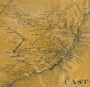
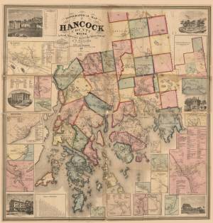
1860 map, including census of towns.
Also filed under: Maps » // Mount Desert Island & Rock » // Penobscot Bay »
1860
Also filed under: Maps »
Library of Congress catalog number 2011588006
Wilson Museum, Castine, Maine also has a copy of the map
Also filed under: Maps »
Wilson Museum, Castine, Maine also has a copy of the map
Library of Congress catalog number 2011588006
Also filed under: Maps »
Bouvé and Sharp, Lithographers, 221 Washington Street, Boston
Boston Athenaeum
Looking at Castine from Hospital Island. Joseph Stevens, Sr. mentions this print in the letter he wrote to Lane encouraging Lane to make a lithograph of Castine.
Also filed under: Bouvé & Sharp, Lith. – Boston » // Homan, S.V. » // Stevens, Joseph, Sr. and Dorothy Little »
Personal diary
Wilson Museum, Castine, Maine (A00060-1a-1h)
Description of an excursion taken by Joseph Stevens, Jr., Lane, Witherle, Samuel Adams, Jr., and George Tilden around the islands of Maine near Mt. Desert. The group hired the Sloop "Superior" which was owned by Pilot Getchell. In his diary, Witherle mentions multiple times that "Lane took a sketch" especially when the water was calm. Lane often stayed on board the boat, while the others went ashore.
Excerpts of the diary include:
August 16: "Lane has a knack for frying fish."
August 17: "leaving Lane to take a sketch, we took a climb."
August 19: "went to ascend one of the highest mountains. 3/4 the way up we had to wait – once in a while for Lane who with his crutches could not keep up with us – but got along faster than we thought possible . . .Lane got up about an hour after the rest of us."
The entire text is transcribed in an account published by the Wilson Museum.
View related catalogue entries (6) »
Also filed under: "Superior" (Sloop) » // Adams, Samuel, Jr. » // Biographical information » // Blue Hill » // Chronology » // Diaries / Ledgers / Etc. » // Mount Desert Island & Rock » // Somes Sound » // Stevens, Joseph, Jr. » // Tilden, George » // Witherle, William Howe »
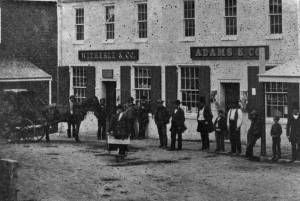
Photograph
Wilson Museum, Castine, Maine
Accession number a02600a
Also filed under: Castine – Witherle & Co.'s Store » // Witherle, William Howe »
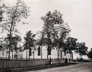
At 88 Court Street, Castine, was the church built between 1790–96 as First Parish Church and greatly remodeled in 1831. It served as the First Parish (Congregational) Church from 1796–1866, after which it became a Unitarian parish. It is noteworthy for its distinctive belfry and spire. Part of the 1831 reconstruction was this new tower, as well as the sending back of the original Revere bell to Boston in exchange for a larger one. Dr. Joseph Stevens was listed as a pew holder in this church in 1832. (2) During the 1840s the congregation at this church dwindled, but the church was still used for town events such as the 4th of July during the Civil War. (2)
References:
1. Lynn Hudson Parsons, Missions and Meeting Houses, Chapels and Churches: Fuor Centuries of Faith in Castine, Maine (Castine, ME: Historical Society, 2012), 60.
2. Ibid., 75.
Photograph Castine Historical Society Collections
Also filed under: Historic Photographs »
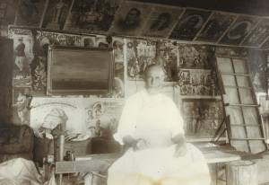
Dennett's sail loft was a well-known Castine institution. The walls were papered with posters, and for reasons lost to time, a figure was photographed there in front of a Lane painting hanging on the wall.
Castine Historical Society
Sailmaker at Dennett’s sail loft in front of Lane painting. From a copy photo in the Castine Historical Society Collections, 1996.
Also filed under: Historic Photographs »
Castine Historical Society Collections (1998.43)
Also filed under: Historic Photographs » // Vessel details: Rigging and Sails »
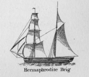
Hermaphrodite brigs—more commonly called half-brigs by American seamen and merchants—were square-rigged only on the fore mast, the main mast being rigged with a spanker and a gaff-topsail. Staysails were often set between the fore and main masts, there being no gaff-rigged sail on the fore mast. (1)
The half-brig was the most common brig type used in the coasting trade and appears often in Lane’s coastal and harbor scenes. The type was further identified by the cargo it carried, if it was conspicuously limited to a specialized trade. Lumber brigs (see Shipping in Down East Waters, 1854 (inv. 212) and View of Southwest Harbor, Maine: Entrance to Somes Sound, 1852 (inv. 260)) and hay brigs (see Lighthouse at Camden, Maine, 1851 (inv. 320)) were recognizable by their conspicuous deck loads. Whaling brigs were easily distinguished by their whaleboats carried on side davits (see ). (2)
– Erik Ronnberg
References:
1. M.H. Parry, et al., Aaak to Zumbra: A Dictionary of the World's Watercraft Newport News, VA: The Mariners’ Museum, 2000), 268, 274; and A Naval Encyclopaedia (L.R. Hamersly & Co., 1884. Reprint: Detroit, MI: Gale Research Company, 1971), 93, under "Brig-schooner."
2. W.H. Bunting, An Eye for the Coast (Gardiner, ME: Tilbury House: 1998), 52–54, 68–69; and W.H. Bunting, A Day's Work, part 1 (Gardiner, ME: Tilbury House: 1997), 52.

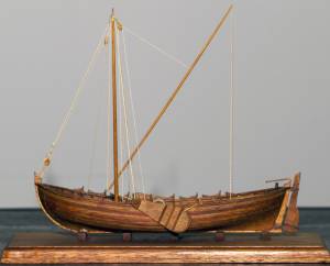
The colonial American shallop is the ancestor of many regional types of New England fishing craft found in Lane's paintings and drawings, including "New England Boats" (known as "boats"), and later descendents, such as "Chebacco Boats," "Dogbodies," and "Pinkies." (discussed elsewhere)
These boats were very common work boat types on Cape Ann throughout the 1800s. They were primarily used for inshore coastal fishing, which included lobstering, gill-netting, fish-trapping, hand-lining, and the like. They were usually sailed by one or two men, sometimes with a boy, and could be rowed as well as sailed. An ordinary catch would include rock cod, flounder, fluke, dabs, or other small flat fish. The catch would be eaten fresh, or salted and stored for later consumption, or used as bait fish. Gill-netting would catch herring and alewives when spawning. Wooden lobster traps were marked with buoys much as they are today, and hauled over the low sides of the boat, emptied of lobsters and any by-catch, re-baited and thrown back.
THE SHALLOP
Like other colonial vessel types, shallops were defined in many ways, including size, construction, and rig. Most commonly, they were open boats with square or sharp sterns, 20 to 30 feet in length, two-masted rigs, and heavy sawnframe construction which in time became lighter. (1)
The smaller shallops developed into a type called the Hampton Boat early in the nineteenth century, becoming the earliest named regional variant of what is now collectively termed the New England Boat. Other variants were named for their regions of origin: Isles of Shoals Boat, Casco Bay Boat, No Mans Land Boat, to name a few. No regional name for a Cape Ann version has survived, and "boat," or "two-masted boat" seems to have sufficed. (2)
Gloucester's New England Boats were mostly double-enders (sharp sterns) ranging in length from 25 to 30 feet, with two masts and two sails (no bowsprit or jib). They were used in the shore fisheries: handlining, gillnetting, and gathering or trapping shellfish (see View from Kettle Cove, Manchester-by-the-Sea, 1847 (inv. 94), View of Gloucester Harbor, 1848 (inv. 97), and /entry: 240/). (3)
Larger, double-ended shallops became decked and evolved in Ipswich (the part now called Essex) to become Chebacco Boats. (4) This variant retained the two-mast, two-sail rig, but evolved further, acquiring a bowsprit and jib and becoming known as a pinky (see Gloucester Harbor from Rocky Neck, 1844 (inv. 14), The Western Shore with Norman's Woe, 1862 (inv. 18), and The Old Fort and Ten Pound Island, Gloucester, 1850s (inv. 30)). The Chebacco Boat became a distinct type by the mid-eighteenth century giving rise to the pinky in the early ninetennth century; the latter, by the early 1900s. (5)
References:
1. William A. Baker, Sloops & Shallops (Barre, MA: Barre Publishing Co., 1966), 27–33; and “Vessel Types of Colonial Massachusetts,” in Seafaring in Colonial Massachusetts (Boston: The Colonial Society of Massachusetts, 1980), 13–15, see figs. 10, 11.
2. Howard I. Chapelle, American Small Sailing Craft (New York: W.W. Norton & Co., 1951), 136–45.
3. Ibid., 145, upper photo, fourth page of plates.
4. Baker, 82–91.
5. Chapelle, The American Fishing Schooners, 1825–1935 (New York: W.W. Norton & Co., 1973), 23–54.
THE NEW ENGLAND BOAT
By the 1840s, the Gloucester version of the New England Boat had evolved into a distinct regional type. Referred to locally as “boats,” the most common version was a double-ender, i.e. having a pointed stern, unlike the less common version having a square stern.
Both variants had two masts, a foresail, a mainsail, but no bowsprit or jib. Lane depicted both in several paintings, beginning in the mid-1840s (see View from Kettle Cove, Manchester-by-the-Sea, 1847 (inv. 94), View of Gloucester Harbor, 1848 (inv. 97), and /entry: 240/), all ranging 25 to 30 feet in length. In View of Gloucester Harbor, 1848 (inv. 97) and Gloucester Inner Harbor, 1850 (inv. 240), a double-ender can be seen on the beach while a square-stern version lies at anchor in the harbor, just to the right of the former. (1)
Lane’s depictions of the double-enders show lapstrake hull planking in View of Gloucester Harbor, 1848 (inv. 97) and Gloucester Inner Harbor, 1850 (inv. 240), and cuddies (short decking) inboard at the ends for shelter and stowage of fishing gear in View from Kettle Cove, Manchester-by-the-Sea, 1847 (inv. 94). The few square-stern examples (see View of Gloucester Harbor, 1848 (inv. 97) and Gloucester Inner Harbor, 1850 (inv. 240)) suggest carvel (smooth) planking and paint finish, rather than oil and tar. The presence of an example of the latter variant in Boston Harbor, as noted in Boston Harbor, c.1850 (inv. 48), suggests a broader geographical range for this subtype. (2)
The primary use of Cape Ann’s “boats” was fishing, making “day trips” to coastal grounds for cod, herring, mackerel, hake, flounder, and lobster, depending on the season. Fishing gear included hooks and lines, gill nets, and various traps made of wood and fish net.
Some boats worked out of Gloucester Harbor, but other communities on Cape Ann had larger fleets, such as Sandy Bay, Pigeon Cove, Folly Cove, Lanesville, Bay View, and Annisquam. Lane’s depictions of these places and their boats are rare to nonexistent. (3)
The double-ended boat served Lane in marking the passage of time in Gloucester Harbor. In View from Kettle Cove, Manchester-by-the-Sea, 1847 (inv. 94), we see new boats setting out to fish, but in View of Gloucester Harbor, 1848 (inv. 97) and Gloucester Inner Harbor, 1850 (inv. 240), a boat of the same type is depicted in a progressively worn state. In Stage Fort across Gloucester Harbor, 1862 (inv. 237), the boat is a stove hulk on a beach, and in the same year, Lane depicted the type’s shattered bottom frame and planking lying on the shore at Norman’s Woe in Norman's Woe, Gloucester Harbor, 1862 (inv. 1).
Regional variants of the New England Boat appear in Lane’s paintings of Maine harbors, including one and two-masted versions, collectively called Hampton Boats (see Bear Island, Northeast Harbor, 1855 (inv. 24), Ten Pound Island at Sunset, 1851 (inv. 25), Fishing Party, 1850 (inv. 50), Father's (Steven's) Old Boat, 1851 (inv. 190), and "General Gates" at Anchor off Our Encampment at Bar Island in Somes Sound, Mount Desert, Maine, 1850 (inv. 192)). Some distinctive regional types were given names, i.e. Casco Bay Boats ("General Gates" at Anchor off Our Encampment at Bar Island in Somes Sound, Mount Desert, Maine, 1850 (inv. 192) may be one), but many local type names, if they were coined, have been lost. (4)
References:
1. Howard I. Chapelle, American Small Sailing Craft (New York: W.W. Norton & Co., 1951), 141–42.
2. Ibid., 152–55.
3. Sylvanus Smith, Fisheries of Cape Ann (Gloucester, MA: Press of the Gloucester Times, 1915), 96–97, 102–05, 110–13.
4. Chapelle, 152–55.
Also filed under: Ship Models »
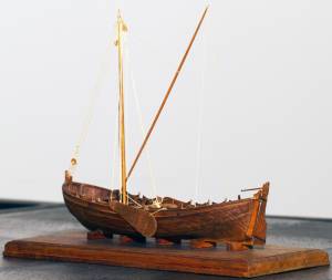
Also filed under: Ship Models »
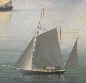
"Party boat" is a colloquial term for any kind of small craft adapted or used for taking guests (customarily for hire) on sightseeing trips or fishing for pleasure. (1) The term survives to this day on Cape Ann and other places for vessels engaged in the same activities. (2) In Lane's time, party boating was a calling of opportunity, and a fisherman's boat might be used in season - regularly or occasionally - to take "rusticators" fishing. Likewise, a boat used for its owner's own pleasure might be hired to take sightseers sailing for an afternoon. The latter use is seen in Lane's 1844 view of Gloucester Harbor from Rocky Neck (see the yawl-rigged sailboat in the foreground of Gloucester Harbor from Rocky Neck, 1844 (inv. 14)).
By the early 1850s, summer visitor activity, encouraged by the building of the Pavilion Hotel on Gloucester's waterfront, led to increased pleasure boating activity, if Lane's painting Gloucester Harbor, 1852 (inv. 38) of Pavilion Beach and Sidney Mason's hotel is any indication. (3) Lane's Gloucester Harbor scenes from this decade show a number of pleasure craft suitable for taking passengers for hire (see Fresh Water Cove from Dolliver's Neck, Gloucester, Early 1850s (inv. 45), Coming Ashore near Brace's Rock, Gloucester, Massachusetts, c.1860 (inv. 60), and View of Gloucester from "Brookbank," the Sawyer Homestead, c.1856 (inv. 95)). Small working craft suitable for this purpose are seen in The Old Fort and Ten Pound Island, Gloucester, 1850s (inv. 30), Gloucester Harbor, 1852 (inv. 38) (right foreground), View of Gloucester, 1859 (inv. 91) (foreground), and Watch House Point, 1860 (inv. 292) (right foreground). In View of Gloucester Harbor, 1848 (inv. 97), we see passengers boarding a small sloop-rigged boat hidden by the rocks at Duncan's Point (left middle ground).
In coastal waters south of Gloucester, a few of Lane's paintings offer pleasure craft as candidates for taking paying passengers. Phantom of Boston, c.1850s (inv. 574) depicts a cruising yawl "Phantom" of Boston, beached with hunting gear unloaded alongside while two of the crew await an approaching party in a rowing boat. The location is unidentified, but a possibility is the barrier beach around the marshes of Lynn, Massachusetts, which were once very popular hunting grounds for migrating waterfowl. A second candidate is a small sloop with a party of four on an evening sail off Halfway Rock in Becalmed Off Halfway Rock, 1860 (inv. 344) (far right).
Lane found similar uses of working watercraft in Maine, where the families of a small coastal community would travel by their workboats to a gathering place for a clambake or similar festive outing (see View of Indian Bar Cove, Brooksville, Maine, 1850 (inv. 61)). The artist became a "rusticator" himself when he, Joseph Stevens, and friends explored Mount Desert Island and vicinity in the "General Gates," a sloop-rigged Maine version of a New England Boat (View of Bar Island and Mount Desert Mountains, from the Bay in Front of Somes Settlement, 1850 (inv. 177) and Castine Harbor and Town, 1851 (inv. 272)).
When Lane traveled to New Bedford in 1856 to observe and sketch a regatta held by the New York Yacht Club, he observed and sketched it while on board an unknown vessel near the starting and finishing line, formed by the race committee boat "Emblem" and her yawl-boat.
Close by was a small party boat with observers on board, probably a fishing sloop, given its work-a-day looks. In the ensuing year, Lane painted four detailed views of this race, the party boat appearing in New York Yacht Club Regatta (1), 1856 (inv. 66) (right foreground); New York Yacht Club Regatta (2), 1856 (inv. 270) (right margin); New York Yacht Club Regatta (3), After 1856 (inv. 396) (center); and New York Yacht Club Regatta (4), 1857 (inv. 397) (left foreground). (4)
– Erik Ronnberg
References:
1. M. H. Parry and others, Aak to Zumbra: A Dictionary of the World's Watercraft (Newport News, VA: The Mariners' Museum, 2000), 436.
2. Ibid.
3. Proctor's Able Sheet (a Gloucester newspaper), January 1857: "Gloucester House reopened—refitted—boats always ready to take parties cruising or fishing..."
4. John Wilmerding, Fitz Henry Lane, 2nd ed. (Cape Ann, MA: Cape Ann Historical Association, 2005), 52–54. Lane's 1852 cruise in the Mount Desert region in the sloop "Superior" was reprinted as an appendix to Wilmerding's essay in Paintings by Fitz Hugh Lane (Washington, DC: National Gallery of Art, 1988), 125–26.
Oil on canvas
34 x 45 3/4 in.
Cape Ann Museum, Gloucester, Mass., Gift of Mrs. Jane Parker Stacy (Mrs. George O. Stacy),1948 (1289.1a)
Detail of party boat.
Also filed under: Gloucester Harbor, Inner / Harbor Cove »

Oil on canvas
22 x 36 in.
Cape Ann Museum, Gloucester, Mass., deposited by the Collection of Addison Gilbert Hospital, 1978 (DEP. 201)
Detail of party boat.
Also filed under: Ten Pound Island »
Newspaper
Ad in Gloucester Telegraph
FISHING AND SAILING PARTIES
"Persons desirous of enjoying a SAILING or FISHING EXCURSION, are informed that the subscriber will be in readiness with the Boat EUREKA, to attend to all who may favor him with their patronage. JOHN J. FERSON"
Also filed under: Gloucester Harbor – Use » // Newspaper / Journal Articles »
Newsprint
Ad for Gloucester House
Courtesy of the American Antiquarian Society, Worcester, Mass.
See p. 4, column 2.
Also filed under: Brick Houses / Gloucester House Hotel » // Newspaper / Journal Articles »
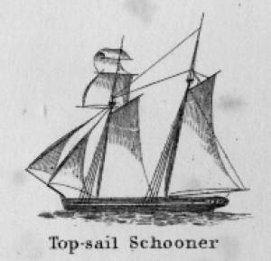
Schooners in Lane’s time were, with few exceptions, two-masted vessels carrying a fore-and-aft rig having one or two jibs, a fore staysail, gaff-rigged fore- and main sails, and often fore- and main topsails. One variant was the topsail schooner, which set a square topsail on the fore topmast. The hulls of both types were basically similar, their rigs having been chosen for sailing close to the wind. This was an advantage in the coastal trade, where entering confined ports required sailing into the wind and frequent tacking. The square topsail proved useful on longer coastwise voyages, the topsail providing a steadier motion in offshore swells, reducing wear and tear on canvas from the slatting of the fore-and-aft sails. (1)
Schooners of the types portrayed by Lane varied in size from 70 to 100 feet on deck. Their weight was never determined, and the term “tonnage” was a figure derived from a formula which assigned an approximation of hull volume for purposes of imposing duties (port taxes) on cargoes and other official levies. (2)
Crews of smaller schooners numbered three or four men. Larger schooners might carry four to six if a lengthy voyage was planned. The relative simplicity of the rig made sail handling much easier than on a square-rigged vessel. Schooner captains often owned shares in their vessels, but most schooners were majority-owned by land-based firms or by individuals who had the time and business connections to manage the tasks of acquiring and distributing the goods to be carried. (3)
Many schooners were informally “classified” by the nature of their work or the cargoes they carried, the terminology coined by their owners, agents, and crews—even sometimes by casual bystanders. In Lane’s lifetime, the following terms were commonly used for the schooner types he portrayed:
Coasting schooners: This is the most general term, applied to any merchant schooner carrying cargo from one coastal port to another along the United States coast (see Bar Island and Mt. Desert Mountains from Somes Settlement, 1850 (inv. 401), right foreground). (4)
Packet schooners: Like packet sloops, these vessels carried passengers and various higher-value goods to and from specific ports on regular schedules. They were generally better-maintained and finished than schooners carrying bulk cargoes (see The Old Fort and Ten Pound Island, Gloucester, 1850s (inv. 30), center; and Gloucester Inner Harbor, 1850 (inv. 240), stern view). (5)
Lumber schooners: Built for the most common specialized trade of Lane’s time, they were fitted with bow ports for loading lumber in their holds (see View of Southwest Harbor, Maine: Entrance to Somes Sound, 1852 (inv. 260)) and carried large deck loads as well (Stage Rocks and the Western Shore of Gloucester Outer Harbor, 1857 (inv. 8), right). Lumber schooners intended for long coastal trips were often rigged with square topsails on their fore masts (see Becalmed Off Halfway Rock, 1860 (inv. 344), left; ; and Lumber Schooner in a Gale, 1863 (inv. 552)). (6)
Schooners in other specialized trades. Some coasting schooners built for carrying varied cargoes would be used for, or converted to, special trades. This was true in the stone trade where stone schooners (like stone sloops) would be adapted for carrying stone from quarries to a coastal destination. A Lane depiction of a stone schooner is yet to be found. Marsh hay was a priority cargo for gundalows operating around salt marshes, and it is likely that some coasting schooners made a specialty of transporting this necessity for horses to urban ports which relied heavily on horses for transportation needs. Lane depicted at least two examples of hay schooners (see Gloucester Harbor, 1850s (inv. 391), left; and Coasting Schooner off Boon Island, c.1850 (inv. 564)), their decks neatly piled high with bales of hay, well secured with rope and tarpaulins.
– Erik Ronnberg
References:
1. Howard I. Chapelle, The History of American Sailing Ships (New York: W.W. Norton & Co., 1935), 258. While three-masted schooners were in use in Lane’s time, none have appeared in his surviving work; and Charles S. Morgan, “New England Coasting Schooners”, The American Neptune 23, no. 1 (DATE): 5–9, from an article which deals mostly with later and larger schooner types.
2. John Lyman, “Register Tonnage and its Measurement”, The American Neptune V, nos. 3–4 (DATE). American tonnage laws in force in Lane’s lifetime are discussed in no. 3, pp. 226–27 and no. 4, p. 322.
3. Ship Registers of the District of Gloucester, Massachusetts, 1789–1875 (Salem, MA: The Essex Institute, 1944). Vessels whose shipping or fishing voyages included visits to foreign ports were required to register with the Federal Customs agent at their home port. While the vessel’s trade or work was unrecorded, their owners and master were listed, in addition to registry dimensions and place where built. Records kept by the National Archives can be consulted for information on specific voyages and ports visited.
4. Howard I. Chapelle, The National Watercraft Collection (Washington, DC: Smithsonian Institution, 1960), 40, 42–43.
5. Ibid., 42–43, 73.
6. Ibid., 74–76.
In R. H. Dana, The Seaman's Friend, 13th ed. (Thomas Groom & Co. Publisher, 1873)
A topsail schooner has no tops at her foremast, and is fore-and-aft rigged at her mainmast. She differs from an hermaphrodite brig in that she is not properly square-rigged at her foremast, having no top, and carrying a fore-and-aft foresail instead of a square foresail and a spencer.

Detail views: marine railway and hauling cradle for vessel Wood rails, metal rollers, chain; wood cradle. Scale: ½" = 1' (1:24) Original diorama components made, 1892; replacements made, 1993. Cape Ann Museum, from Gloucester Chamber of Commerce, 1925 (2014.071)
A schooner is shown hauled out on a cradle which travels over racks of rollers on a wood and metal track.
Also filed under: Burnham Brothers Marine Railway » // Marine Railways »

c. 1900 Glass plate negative Collection of Erik Ronnberg
Also filed under: Lobstering »
"The Maine Register for the Year 1855, embracing State and County Officers, and an abstract of the law and resolves; together with a complete business directory of the state, and a variety of useful information."
Details about Maine's lumber trade in 1855, see pp. 250–52
Also filed under: Castine » // Lumber Industry »

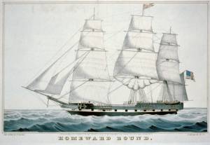
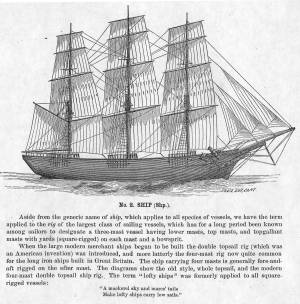
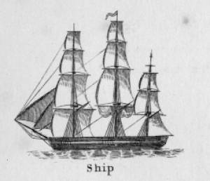
The term "ship," as used by nineteenth-century merchants and seamen, referred to a large three-masted sailing vessel which was square-rigged on all three masts. (1) In that same period, sailing warships of the largest classes were also called ships, or more formally, ships of the line, their size qualifying them to engage the enemy in a line of battle. (2) In the second half of the nineteenth century, as sailing vessels were replaced by engine-powered vessels, the term ship was applied to any large vessel, regardless of propulsion or use. (3)
Ships were often further defined by their specialized uses or modifications, clipper ships and packet ships being the most noted examples. Built for speed, clipper ships were employed in carrying high-value or perishable goods over long distances. (4) Lane painted formal portraits of clipper ships for their owners, as well as generic examples for his port paintings. (5)
Packet ships were designed for carrying capacity which required some sacrifice in speed while still being able to make scheduled passages within a reasonable time frame between regular destinations. In the packet trade with European ports, mail, passengers, and bulk cargos such as cotton, textiles, and farm produce made the eastward passages. Mail, passengers (usually in much larger numbers), and finished wares were the usual cargos for return trips. (6) Lane depicted these vessels in portraits for their owners, and in his port scenes of Boston and New York Harbors.
Ships in specific trades were often identified by their cargos: salt ships which brought salt to Gloucester for curing dried fish; tea clippers in the China Trade; coffee ships in the West Indies and South American trades, and cotton ships bringing cotton to mills in New England or to European ports. Some trades were identified by the special destination of a ship’s regular voyages; hence Gloucester vessels in the trade with Surinam were identified as Surinam ships (or barks, or brigs, depending on their rigs). In Lane’s Gloucester Harbor scenes, there are likely (though not identifiable) examples of Surinam ships, but only the ship "California" in his depiction of the Burnham marine railway in Gloucester (see Three Master on the Gloucester Railways, 1857 (inv. 29)) is so identified. (7)
– Erik Ronnberg
References:
1. R[ichard)] H[enry] Dana, Jr., The Seaman’s Friend, 13th ed. (Boston: Thomas Groom & Co., 1873), p. 121 and Plate IV with captions.
2. A Naval Encyclopaedia (Philadelphia: L. R. Hamersly & Co., 1884), 739, 741.
3. M.H. Parry, et al., Aak to Zumbra: A Dictionary of the World’s Watercraft (Newport News, VA: The Mariners’ Museum, 2000), 536.
4. Howard I. Chapelle, The History of American Sailing Ships (New York: W.W. Norton & Co., 1935), 281–87.
5. Ibid.
6. Howard I. Chapelle, The National Watercraft Collection (Washington, DC: Smithsonian Institution, 1960), 26–30.
7. Alfred Mansfield Brooks, Gloucester Recollected: A Familiar History (Gloucester, MA: Peter Smith, 1974), 67–69.
Photograph
From American Clipper Ships 1833–1858, by Octavius T. Howe and Frederick C. Matthews, vol. 1 (Salem, MA: Marine Research Society, 1926).
Photo caption reads: "'Golden State' 1363 tons, built at New York, in 1852. From a photograph showing her in dock at Quebec in 1884."
Also filed under: "Golden State" (Clipper Ship) »
_sm.jpg)

Oil on canvas
24 x 35 in.
Peabody Essex Museum, Salem, Mass.
Walters' painting depicts the "Nonantum" homeward bound for Boston from Liverpool in 1842. The paddle-steamer is one of the four Clyde-built Britannia-class vessels, of which one is visible crossing in the opposite direction.
View related catalogue entries (2) »
Also filed under: Packet Shipping » // Walters, Samuel »
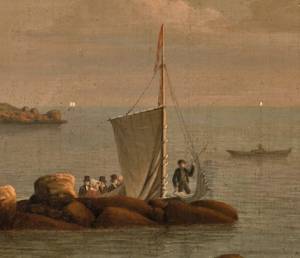
The yawl boat was a ninteenth-century development of earlier ships' boats built for naval and merchant use. Usually twenty feet long or less, they had round bottoms and square sterns; many had raking stem profiles. Yawl boats built for fishing tended to have greater beam than those built for vessels in the coastal trades. In the hand-line fisheries, where the crew fished from the schooner's rails, a single yawl boat was hung from the stern davits as a life boat or for use in port. Their possible use as lifeboats required greater breadth to provide room for the whole crew. In port, they carried crew, provisions, and gear between schooner and shore. (1)
Lane's most dramatic depictions of fishing schooners' yawl-boats are found in his paintings Gloucester Outer Harbor, from the Cut, 1850s (inv. 109) and /entry:311. Their hull forms follow closely that of Chapelle's lines drawing. (2) Similar examples appear in the foregrounds of Gloucester Harbor, 1852 (inv. 38), Ships in Ice off Ten Pound Island, Gloucester, 1850s (inv. 44), and The Fort and Ten Pound Island, Gloucester, Massachusetts, 1847 (inv. 271). A slightly smaller example is having its bottom seams payed with pitch in the foreground of Gloucester Harbor, 1847 (inv. 23). In Gloucester Inner Harbor, 1850 (inv. 240), a grounded yawl boat gives an excellent view of its seating arrangement, while fishing schooners in the left background have yawl boats hung from their stern davits, or floating astern.
One remarkable drawing, Untitled, n.d. (inv. 219) illustrates both the hull geometry of a yawl boat and Lane's uncanny accuracy in depicting hull form in perspective. No hull construction other than plank seams is shown, leaving pure hull form to be explored, leading in turn to unanswered questions concerning Lane's training to achieve such understanding of naval architecture.
– Erik Ronnberg
References:
1. Howard I. Chapelle, American Small Sailing Craft (New York: W.W. Norton & Co., 1951), 222–23.
2. Ibid., 223.
Oil on canvas
12 1/8 x 19 3/4 in.
Museum of Fine Arts, Boston, Bequest of Martha C. Karolik for the M.and M. Karolik Collection of American Paintings, 1815-1865 (48.447)
A schooner's yawl lies marooned in the ice-bound harbor in this detail.
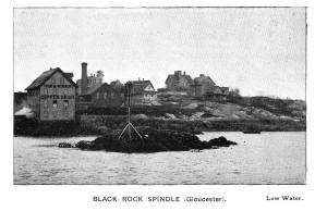
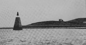
A "spindle" is a fixed marker to indicate a hazard to navigation (such as a rock which couldn't be seen at high tide). It serves the same purpose as a channel buoy, a "light beacon," or a “monument,” to warn vessels away from dangerous places or stretches of coastline. Spindles are usually iron rods with some sort of geometric object (round, flat, or triangular) on top, brightly painted (usually red) for visibility. Monuments, like the ones you see in Lane’s depictions of Half Way Rock or Norman’s Woe Reef, were made of stone and look like stumpy obelisks—or grave monuments. They were also essential as reference points for the early coastal surveys in their efforts to make more accurate charts.
In Castine, the notable square monument in the center of the harbor marked Hosmer's Ledge.

Photograph in The Illustrated Coast Pilot with Sailing Directions. The Coast of New England from New York to Eastport, Maine including Bays and Harbors, published by N. L. Stebbins, Boston
Also filed under: Gloucester Harbor, Inner / Harbor Cove »

Pencil and ink on paper
15 x 22 1/8 in.
Cape Ann Museum, Gloucester, Mass., Gift of Mr. Donald K. Usher, in memory of Mrs. Margaret Campbell Usher, 1984 (2401.19)
Also filed under: Gloucester Harbor, Outer » // Mackerel Fishing »
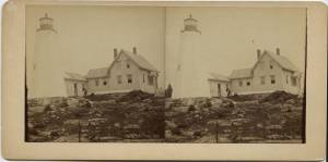
Stereograph card Castine Historical Society Collections (1996.1)
View related catalogue entries (2) »
Also filed under: Castine » // Historic Photographs »
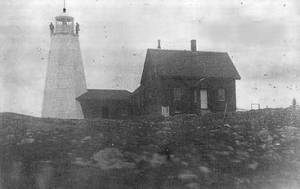
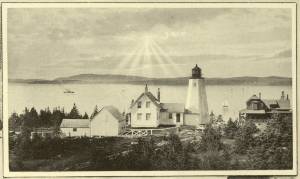
The Dice Head Lighthouse is situated on the southernmost point of the Castine Peninsula at the mouth of the Penobscot River. In May of 1828, Congress gave $5,000 for the creation of a lighthouse at Dice Head in response to the growing shipbuilding and lumber industries on the Penobscot River; it was first lit on November 5, 1828. In the years after the 42-foot conical rubblestone Dice Head Lighthouse was built, it was plagued by physical damage and concerns over its effectiveness in guiding vessels. An inspection report from I.W.P Lewis in 1843 described the lighthouse as "out of repair altogether" and he echoed the sentiment of Henry D. Hunter, of the U.S. revenue cutter, "Jackson," that the Dice Head Lighthouse is helpful in navigating the Bay of Castine, but poorly placed to guide navigators in the Penobscot Bay and at the mouth of the Penobscot River.
This information has been shared with the Lane project by Jeremy D'Entremont. More information can be found at his website, www.newenglandlighthouses.net or in The Lighthouse Handbook New England.
Stereograph card Castine Historical Society Collections (1996.1)
Also filed under: Castine » // Historic Photographs »
Photograph
In The Illustrated Coast Pilot with sailing directions. The Coast of New England from New York to Eastport, Maine including Bays and Harbors, published by N. L. Stebbins, Boston, Mass.
Also filed under: Castine »
Photograph
National Archives
Photography courtesy of : http://www.newenglandlighthouses.net
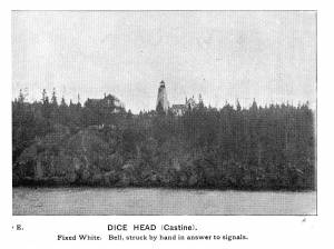
As shipbuilding and lumber traffic on the Penobscot River flourished, Congress appropriated $5,000 for a light station in May 1828. The site chosen was Dice Head, the southernmost point of the Castine peninsula, almost two miles east of the northern end of Islesboro.
The spot is on land once owned by a family named Dyce. Although both spellings have often been used, the "Dice" spelling has predominated.
A conical rubblestone tower—42 feet tall from its base to the focal plane—and an adjacent one-and-one-half-story rubblestone dwelling were soon built, and a newspaper notice on November 5, 1828, announced that the light would go into service that evening.
An octagonal wrought-iron lantern held 10 lamps and 14-inch reflectors, showing a fixed white light 129 feet above mean high water.
The timber trade played an important role in New England’s economy from Colonial days through the mid-19th century, supplying the vast quantities of lumber which a rapidly growing nation demanded. While Cape Ann’s woodlands were depleted early on, timber continued to be harvested from northern New England and the Maritime Provinces right up to the Civil War.
With a deep and safe harbor, Gloucester often served as a layover spot where vessels bound from Maine to Boston, New York or Baltimore and heavily laden with lumber could ride out bad weather. Because of this, Fitz Henry Lane’s paintings of Gloucester Harbor often show a schooner or a brig, loads of lumber clearly visible on their decks, sheltering along the Western Shore.
References:
Honey, Mark E., "King Pine, Queen Spruce, Jack Tar," An Intimate History of Lumbering on the Union River, Volumes 1-5. This source, in its entirety, lays down the foundation of Downeast Maine's unique culture which was built upon pine lumber and timber, the cod fisheries, coasting, shipbuilding, and the interrelationships of family and community.

1852 Photograph
Also filed under: Schooner (Coasting / Lumber / Topsail / Packet / Marsh Hay) »
Advertisement for The Bangor News Company, est. January 31, 1881 Castine Historical Society Collections (2008.02)
Also filed under: Historic Photographs »
"The Maine Register for the Year 1855, embracing State and County Officers, and an abstract of the law and resolves; together with a complete business directory of the state, and a variety of useful information."
Details about Maine's lumber trade in 1855, see pp. 250–52
Also filed under: Castine » // Schooner (Coasting / Lumber / Topsail / Packet / Marsh Hay) »
Lane's watercolor of Castine Castine Harbor and Town, 1851 (inv. 277) notes that it was painted for Noah Brooks, a newspaper reporter, journalist, and author who counted Abraham Lincoln among his friends. Brooks owned the painting made after that watercolor, and donated it to the Castine public library upon his death in 1903. His will stated: "I also give and bequeath to said town for the public library of said town the portrait of the Baron de Castine and Lane's painting of Castine."
Noah Brooks was born in Castine in 1830. At age eighteen, he left Castine for Boston, but returned to town in the summer of 1848, a visit he wrote about in a diary now located at the Castine Historical Society. From Boston, he moved to Illinois, California, and Washington, D.C.. He wrote an article about Castine in 1882 for the Century Magazine. In the Castine Historical Society, there is a biographical account of Brooks written by Gardiner E. Gregory, from which much of this information is drawn.
Personal diary
Castine Historical Society
From July 25-August 16,1848, Castine native Noah Brooks made a return visit to his hometown. He was eighteen at the time, and had been living in Boston. In his diary, there is no mention of Lane, but he recounts Castine gossip, and writes about visits with the Stevens and Witherle familes, accounts of swimming in Back Cove, and reading Wuthering Heights. The daily arrival of "the boat" (the "T.F.S." or the "Secor")—the way it was anticipated and observed by Castine residents—is notable.
Also filed under: "T. F. Secor" (Steamboat) » // Castine » // Diaries / Ledgers / Etc. » // Steamers » // Stevens, Joseph, Sr. and Dorothy Little » // Witherle, William Howe »
Wilson Museum, Castine, Maine
This photo shows Lane's painting Castine Harbor and Town hanging on the wall of Brooks's library in his home in Castine.
Also filed under: Historic Photographs »