An online project under the direction of the CAPE ANN MUSEUM
Catalogue Entry
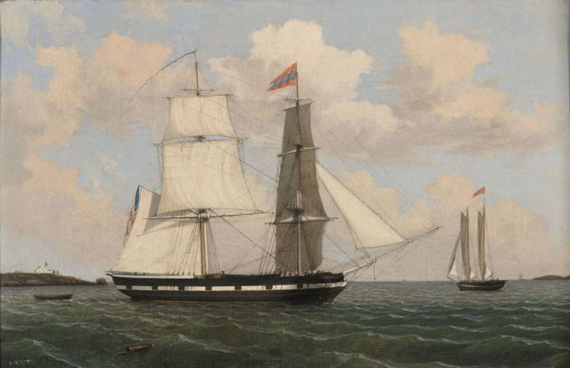
In the 1840s, the economy of Gloucester was booming, thanks to the railroad and the Surinam trade. Edward Babson, a Gloucester sea captain and owner of the brig "Cadet," was one of those making money in the trade. By 1836, Edward Babson and his brother John James had become co-owners of the "Cadet," and for the next decade, Edward sailed her back and forth to South America, becoming one of Gloucester’s most successful Surinam trading captains.
Gloucester merchant ships traded salt fish for molasses, the salt fish being destined for slaves, and the molasses for the New England rum business. The round-trip averaged about four months; Edward was a very competitive sailor and took great pride in making his time at sea as short as possible. Below are excerpts of the "Cadet" logbooks and related diaries of the Babson family, a fascinating window into the everyday reality of life at sea.
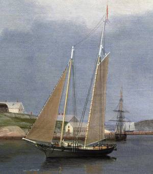
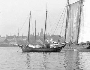
Edward Babson commissioned Lane to paint his brig, probably sometime in the early 1840s. The ship's portrait was a stock-in-trade for marine painters of the time, usually commissioned just after the vessel was built or came under new ownership. Painting ships' portraits, often for prominent Boston ship owners, was how Lane supported himself in his first years as a painter.
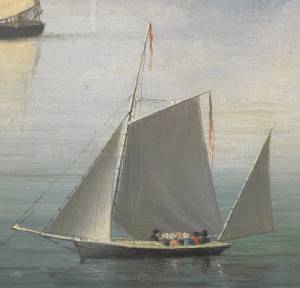
Brig "Cadet" in Gloucester Harbor shows the typical broadside view of the vessel, here in the outer harbor with Ten Pound Island Light in the background to the left. The "Cadet" is flying her name pennant and a long merchant pennant. She is probably outward-bound on a journey to Surinam, but hove to, with her foresails aback. She is perhaps waiting to pick up a pilot from—or deliver a pilot to—the small merchant schooner to the right. The pilot would travel in the dory seen trailing behind the brig.
– Sam Holdsworth
- Subject Types
: - Vessel Types
: - Brig »
- Named Vessel »
- Schooner »
- Cape Ann Locales
: - Objects
: - Building Types
:
Historical Materials
Oil on canvas
17 1/4 x 25 3/4 in.
Cape Ann Museum, Gloucester, Mass., Gift of Isabel Babson Lane, 1946 (1147.a)
Photo: Cape Ann Museum
Detail of brig "Cadet."
Filed under: "Cadet" (Brig) » // Brig »
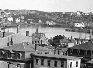
The northeast quarter of Gloucester Harbor is an inlet bounded by Fort Point and Rocky Neck at its entrance. It is further indented by three coves: Harbor Cove and Vincent’s Cove on its north side, and Smith’s Cove on its south side. The shallow northeast end is called Head of the Harbor. Collectively, this inlet with its coves and shallows is called Inner Harbor.
The entrance to Inner Harbor is a wide channel bounded by Fort Point and Duncan’s Point on its north side, and by Rocky Neck on its south side. From colonial times to the late nineteenth century, it was popularly known as “the Stream” and served as anchorage for deeply loaded vessels for “lightering” (partial off-loading). Subsequently it was known as “Deep Hole.”
Of Inner Harbor’s three coves, Harbor Cove (sometimes called “Old Harbor” in later years) was the deepest and most heavily used by fishing vessels in the Colonial Period, and largely dominated by the foreign trade in the first half of the nineteenth century. Its shallow bottom was the undoing of the foreign trade, as larger vessels became too deep to approach its wharves, and the cove returned to servicing a growing fishing fleet in the 1850s.
Vincent’s Cove, a smaller neighbor to Harbor Cove, was bare ground at low tide, and mostly useless for wharfage. Its shoreline was well suited for shipbuilding, and the cove was deep enough at high tide for launching. Records of shipbuilding there prior to the early 1860s have to date not been found.Smith’s Cove afforded wharfage for fishing vessels at its east entrance, as seen in Lane’s lithograph View of the Town of Gloucester, Mass., 1836 (inv. 86). The rest of the cove saw little use until the expansion of the fisheries after 1865.
The Head of the Harbor begins at the shallows surrounding Five Pound Island, extending to the harbor’s northeast end. Lane’s depiction of this area in Gloucester Harbor, 1847 (inv. 23) shows the problems faced by vessel owners at low tide. Despite the absence of deep water, this area saw rapid development after 1865 when a thriving fishing industry needed waterfront facilities, even if they were accessible only at high tide.
– Erik Ronnberg

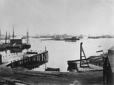
c.1870 Cape Ann Museum Library & Archive (2013.068)
Schooner fleet anchored in the inner harbor. Looking east from Rocky Neck, Duncan's Point wharves and Lane house (at far left), Sawyer School cupola on Friend Street.
Also filed under: Duncan's Point » // Historic Photographs » // Schooner (Fishing) » // Waterfront, Gloucester »
1876 Photograph Cape Ann Museum Library & Archive
Also filed under: Historic Photographs » // Schooner (Fishing) » // Waterfront, Gloucester »

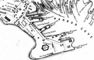
1851 44 x 34 in. Henry Francis Walling, Map of the Towns of Gloucester and Rockport, Essex Co. Massachusetts. Philadelphia, A. Kollner, 1851 Cape Ann Museum Library & Archive
"Map of the Towns of Gloucester and Rockport, Massachusetts. H.F. Walling, Civil Engineer. John Hanson, Printer. 1851. Population of Gloucester in 1850 7,805. Population of Rockport in 1850 3,213."
Also filed under: Baptist Church (Old, First, 1830) (Pleasant Street) » // Burnham Brothers Marine Railway » // Duncan's Point » // Five Pound Island » // Flake Yard » // Harbor Methodist Church (Prospect Street) » // Low (Frederick G.) wharves » // Pavilion Hotel » // Procter Brothers » // Ropewalk » // Vincent's Cove » // Western Shore »

4 x 6 in.
Cape Ann Museum, Benham Collection
George Steele sail loft, William Jones spar yard, visible across harbor. Photograph is taken from high point on the Fort, overlooking business buildings on the Harbor Cove side.
Also filed under: Fort (The) and Fort Point » // Town House » // Universalist Church (Middle and Church Streets) » // Waterfront, Gloucester »


1834–35 Lithograph 24 x 38 in. Gloucester City Archives
"Drawn on a scale of one hundred feet to an inch. By John Mason 1834–45 from Actual Survey showing every Lott and building then standing on them giving the actual size of the buildings and width of the streets from the Canal to the head of the Harbour & part of Eastern point as farr as Smith's Cove and the Shore of the same with all the wharfs then in use. Gloucester Harbor 1834–35."
This map shows the location of F. E. Low's wharf and the ropewalk. Duncan's Point, the site where Lane would eventually build his studio, is also marked.
The later notes on the map are believed to be by Mason.
Also filed under: Duncan's Point » // Low (Frederick G.) wharves » // Low, Capt. Frederick Gilman » // Maps » // Mason, John » // Residences » // Ropewalk » // Somes, Capt. John »
44 x 34 in.
Henry Francis Walling, Map of the Towns of Gloucester and Rockport, Essex Co. Massachusetts. Philadelphia, A. Kollner, 1851
Cape Ann Museum Library & Archive
"Map of the Towns of Gloucester and Rockport, Massachusetts. H.F. Walling, Civil Engineer. John Hanson, Publisher. 1851. Population of Gloucester in 1850 7,805. Population of Rockport in 1850 3,213."
Segment of Harbor Village portion of map showing Collins' and other wharves in the Inner Harbor.
Also filed under: Graving Beach »

Collection of Erik Ronnberg
View related catalogue entries (2) »
Also filed under: Dolliver's Neck » // Fresh Water Cove » // Gloucester Harbor, Outer » // Maps »

1865 41 x 29 inches Courtesy of the Massachusetts Archives Maps and Plans, Third Series Maps, v.66:p.1, no. 2352, SC1/series 50X
.
Also filed under: Burnham Brothers Marine Railway » // Collins's, William (estate wharf) » // Maps » // Rogers's (George H.) wharves »
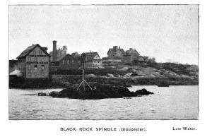
Photograph in The Illustrated Coast Pilot with Sailing Directions. The Coast of New England from New York to Eastport, Maine including Bays and Harbors, published by N. L. Stebbins, Boston
Also filed under: Beacons / Monuments / Spindles »
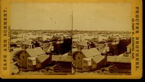
Stereograph card Cape Ann Museum Library & Archive
Also filed under: Gloucester – City Views » // Historic Photographs »
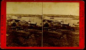
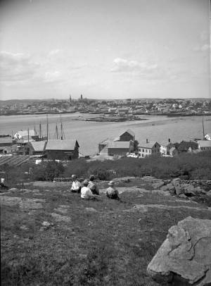
c.1870s Stereograph card Cape Ann Museum Library & Archive
From East Gloucester looking towards Gloucester.
Also filed under: Gloucester – City Views » // Historic Photographs »
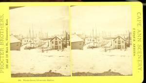
1876 Stereograph card Cape Ann Museum Library & Archive
Stereo view showing Gloucester Harbor after a heavy snowfall
Also filed under: Historic Photographs » // Waterfront, Gloucester »
Cape Ann Museum Library & Archive
Five Pound Island and Gloucester inner harbor taken from the top of Hammond Street building signs in foreground are for Severance, Carpenter and Crane, and Cooper at Clay Cove.
Also filed under: Five Pound Island »
1852
Oil on canvas
28 x 48 1/2 in.
Cape Ann Museum, Gloucester, Mass., Deposited by the City of Gloucester, 1952. Given to the city by Mrs. Julian James in memory of her grandfather Sidney Mason, 1913 (DEP. 200)
Detail of fishing schooner.
Also filed under: Schooner (Fishing) »
Oil on canvas
34 x 45 3/4 in.
Cape Ann Museum, Gloucester, Mass., Gift of Mrs. Jane Parker Stacy (Mrs. George O. Stacy),1948 (1289.1a)
Detail of party boat.
Also filed under: Party Boat »
c.1869 Glass plate negative Cape Ann Museum Library & Archive Detail from CAHA#00279
The magnificent views of Gloucester Harbor and the islands from the top floor of the stone house at Duncan's Point where Lane had his studio were the inspiration for many of his paintings.
From Buck and Dunlop, Fitz Henry Lane: Family, and Friends, pp. 59–74.
Also filed under: Duncan's Point » // Lane's Stone House, Duncan's Point » // Residences »
Glass plate negative
3 x 4 in.
Cape Ann Museum Library & Archive
#10112
Also filed under: Chebacco Boat / Dogbody / Pinky »

1876 Photograph Cape Ann Museum Library & Archive
Ignatius Weber's windmill (now defunct) is shown.
Also filed under: Flake Yard » // Fort (The) and Fort Point » // Historic Photographs » // Rogers's (George H.) wharves » // Schooner (Fishing) » // Waterfront, Gloucester » // Windmill »

1860 In John J. Babson, History of the Town Gloucester (Gloucester, MA: Procter Brothers, 1860) Cape Ann Museum Library & Archives, Gloucester, Mass.
See p. 474.
View related catalogue entries (4) »
Also filed under: Babson History of the Town of Gloucester » // Chebacco Boat / Dogbody / Pinky » // Fort (The) and Fort Point » // Gloucester, Mass. - "Ten Pound Island Light » // Schooner (Coasting / Lumber / Topsail / Packet / Marsh Hay) » // Ten Pound Island »
Ten Pound Island guards the entrance to Gloucester’s Inner Harbor and provides a crucial block to heavy seas running southerly down the Outer Harbor from the open ocean beyond. The rocky island and its welcoming lighthouse is seen, passed, and possibly blessed by every mariner entering the safety of Gloucester’s Inner Harbor after outrunning a storm at sea. Ten Pound Island is situated such that the Inner Harbor is protected from open water on all sides making it one of the safest harbors in all New England.
Legend has it that the island was named for the ten pound sum paid to the Indians for the island, and the smaller Five Pound Island deeper in the Inner Harbor was purchased for that lesser sum. None of it makes much financial sense when the entirety of Cape Ann was purchased for only seven pounds from the Indian Samuel English, grandson of Masshanomett the Sagamore of Agawam in 1700. From approximately 1640 on the island was used to hold rams, and anyone putting female sheep on the island was fined. Gloucester historian Joseph Garland has posited that the name actually came from the number of sheep pens it held, or pounds as they were called, and the smaller Five Pound Island was similarly named.
The island itself is only a few acres of rock and struggling vegetation but is central to the marine life of the harbor as it defines the eastern edge of the deep channel used to turn the corner and enter the Inner Harbor. The first lighthouse was lit there in 1821, and a house was built for the keeper adjacent to the lighthouse.
In the summer of 1880 Winslow Homer boarded with the lighthouse keeper and painted some of his most masterful and evocative watercolor views of the busy harbor life swirling about the island at all times of day. Boys rowing dories, schooners tacking in and out in all weather, pleasure craft drifting in becalmed water, seen together they tell a Gloucester story of light, water and sail much as Lane’s work did only several decades earlier.

Colored lithograph
Cape Ann Museum Library and Archive
Also filed under: Gloucester, Mass. - "Ten Pound Island Light »

Photograph
From The Illustrated Coast Pilot with Sailing Directions. The Coast of New England from New York to Eastport, Maine including Bays and Harbors, N. L. Stebbins, 1891.
Also filed under: Gloucester, Mass. - "Ten Pound Island Light »


Oil on canvas
22 x 36 in.
Cape Ann Museum, Gloucester, Mass., deposited by the Collection of Addison Gilbert Hospital, 1978 (DEP. 201)
Detail of party boat.
Also filed under: Party Boat »

Engraving of 1819 survey taken from American Coast Pilot 14th edition
9 1/2 x 8 in.
Cape Ann Museum Library & Archive
D32 FF5
Also filed under: Dolliver's Neck » // Eastern Point » // Maps » // Norman's Woe »
Newspaper
Gloucester Telegraph
"By the will of the late Fitz H. Lane, Esq., his handsome painting of the Old Fort, Ten Pound Island, etc., now on exhibition at the rooms of the Gloucester Maritime Insurance Co., was given to the town... It will occupy its present position until the town has a suitable place to receive it."

Stereograph card
Cape Ann Museum Library & Archive
View from top of Unitarian Church on Middle Street looking southeast, showing the Fort and Ten Pound Island. Tappan Block and Main Street buildings between Center and Hancock in foreground.
Also filed under: Fort (The) and Fort Point » // Unitarian Church / First Parish Church (Middle Street) »
1860 In John J. Babson, History of the Town Gloucester (Gloucester, MA: Procter Brothers, 1860) Cape Ann Museum Library & Archives, Gloucester, Mass.
See p. 474.
View related catalogue entries (4) »
Also filed under: Babson History of the Town of Gloucester » // Chebacco Boat / Dogbody / Pinky » // Fort (The) and Fort Point » // Gloucester Harbor, Inner / Harbor Cove » // Gloucester, Mass. - "Ten Pound Island Light » // Schooner (Coasting / Lumber / Topsail / Packet / Marsh Hay) »
The brig "Cadet," 207 tons, was built by Thatcher Magoun of Medford, Massachusetts in 1821 and registered at Boston in 1826 and 1828. The original owners of the vessel were William Babson, Jr., Elias Davis, William Grover, John Somes, James Saville, Winthrop Sargent, and William Parsons, Jr. The master was William Grover. When she was registered at Boston in 1836, the owners were listed as John J. Babson, William Babson, Edward Babson, John Somes, and William Grover. Subsequent additional listed owners were Edward E. Dawson, David F. Babson, David S. Day, Elias S. Davison.
Reference:
Ship Registers of the District of Gloucester, Massachusetts, 1789–1875 (Salem, MA: Essex Institute, 1944).
Newspaper
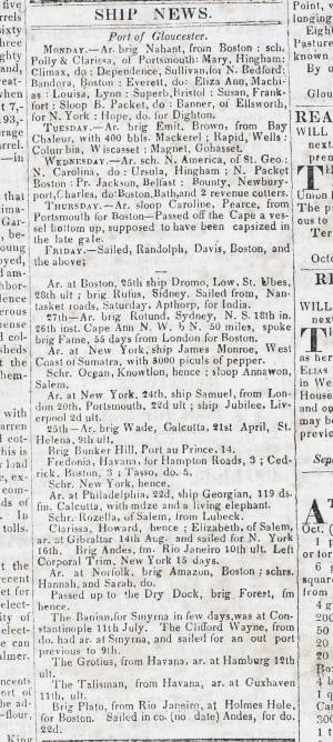
Gloucester Telegraph Ship News
American Antiquarian Society
List of ships arriving and departing the ports of Gloucester and Boston, with details of cargo.
Also filed under: Newspaper / Journal Articles » // Trade Routes and Statistics »
Transcription by Stephanie Buck.
Cape Ann Museum Library and Archive
Also filed under: Babson, Amanda Stanwood » // Babson, Edward » // Diaries / Ledgers / Etc. »
Oil on canvas
17 1/4 x 25 3/4 in.
Cape Ann Museum, Gloucester, Mass., Gift of Isabel Babson Lane, 1946 (1147.a)
Photo: Cape Ann Museum
Detail of brig "Cadet."
Also filed under: Brig »
Also filed under: Babson, Edward » // Diaries / Ledgers / Etc. »
Painting on board
72 x 48 in.
Collection of Erik Ronnberg
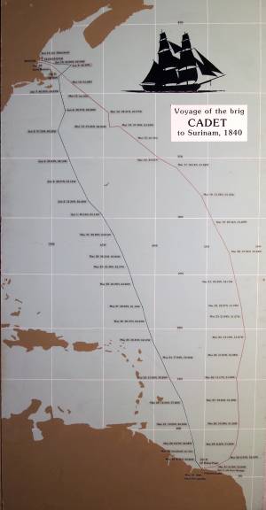
Chart showing the voyage of the brig Cadet to Surinam and return, March 10–June 11, 1840.
Also filed under: Brig » // Surinam Trade »
Manuscript
Cape Ann Museum Library and Archive
Also filed under: Babson, Edward » // Diaries / Ledgers / Etc. » // Surinam Trade »
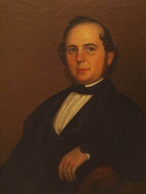
Oil on canvas
27 x 34 in.
Cape Ann Museum, Gloucester, Mass.
Edward Babson was master of the brig "Cadet" at the time when Lane painted the vessel’s portrait.
Also filed under: Babson, Edward »
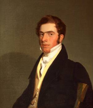
Oil on canvas
Cape Ann Museum, Gloucester, Mass., Bequest of E. Hyde Cox (1998.36.01)
Also filed under: "Boston" (Packet Ship) » // Knight, Elias Davis »
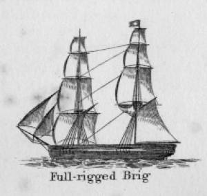
In general, brigs were small to medium size merchant vessels, generally ranging between 80 and 120 feet in hull length. Their hull forms ranged from sharp-ended (for greater speed; see Brig "Antelope" in Boston Harbor, 1863 (inv. 43)) to “kettle-bottom” (a contemporary term for full-ended with wide hull bottom for maximum cargo capacity; see Ships in Ice off Ten Pound Island, Gloucester, 1850s (inv. 44) and Boston Harbor, c.1850 (inv. 48)). The former were widely used in the packet trade (coastwise or transoceanic); the latter were bulk-carriers designed for long passages on regular routes. (1) This rig was favored by Gloucester merchants in the Surinam Trade, which led to vessels so-rigged being referred to by recent historians as Surinam brigs (see Brig "Cadet" in Gloucester Harbor, late 1840s (inv. 13) and Gloucester Harbor at Dusk, c.1852 (inv. 563)). (2)
Brigs are two-masted square-rigged vessels which fall into three categories:
Full-rigged brigs—simply called brigs—were fully square-rigged on both masts. A sub-type—called a snow—had a trysail mast on the aft side of the lower main mast, on which the spanker, with its gaff and boom, was set. (3)
Brigantines were square-rigged on the fore mast, but set only square topsails on the main mast. This type was rarely seen in America in Lane’s time, but was still used for some naval vessels and European merchant vessels. The term is commonly misapplied to hermaphrodite brigs. (4)
Hermaphrodite brigs—more commonly called half-brigs by American seamen and merchants—were square-rigged only on the fore mast, the main mast being rigged with a spanker and a gaff-topsail. Staysails were often set between the fore and main masts, there being no gaff-rigged sail on the fore mast.
– Erik Ronnberg
References:
1. Howard I. Chapelle, The National Watercraft Collection (Washington, DC: Smithsonian Institution, 1960), 64–68.
2. Alfred Mansfield Brooks, Gloucester Recollected: A Familiar History (Gloucester, MA: Peter Smith, 1974), 62–74. A candid and witty view of Gloucester’s Surinam Trade, which employed brigs and barks.
3. R[ichard] H[enry] Dana, Jr., The Seaman's Friend (Boston: Thomas Groom & Co., 1841. 13th ed., 1873), 100 and Plate 4 and captions; and M.H. Parry, et al., Aak to Zumbra: A Dictionary of the World's Watercraft (Newport News, VA: The Mariners’ Museum, 2000), 95.
4. Parry, 95, see Definition 1.
Oil on canvas
17 1/4 x 25 3/4 in.
Cape Ann Museum, Gloucester, Mass., Gift of Isabel Babson Lane, 1946 (1147.a)
Photo: Cape Ann Museum
Detail of brig "Cadet."
Also filed under: "Cadet" (Brig) »
Painting on board
72 x 48 in.
Collection of Erik Ronnberg
Chart showing the voyage of the brig Cadet to Surinam and return, March 10–June 11, 1840.
Also filed under: "Cadet" (Brig) » // Surinam Trade »

The ensign of the United States refers to the flag of the United States when used as a maritime flag to indentify nationality. As required on entering port, a vessel would fly her own ensign at the stern, but a conventional token of respect to the host country would be to fly the flag of the host country (the United States in Boston Harbor, for example) at the foremast. See The "Britannia" Entering Boston Harbor, 1848 (inv. 49) for an example of a ship doing this. The American ensign often had the stars in the canton arranged in a circle with one large star in the center; an alternative on merchant ensigns was star-shaped constellation. In times of distress a ship would fly the ensign upside down, as can be seen in Wreck of the Roma, 1846 (inv. 250).
The use of flags on vessels is different from the use of flags on land. The importance and history of the flagpole in Fresh Water Cove in Gloucester is still being studied.
The modern meaning of the flag was forged in December 1860, when Major Robert Anderson moved the U.S. garrison from Fort Moultrie to Fort Sumter in Charleston Harbor. Adam Goodheart argues this was the opening move of the American Civil War, and the flag was used throughout northern states to symbolize American nationalism and rejection of secessionism.
Before that day, the flag had served mostly as a military ensign or a convenient marking of American territory, flown from forts, embassies, and ships, and displayed on special occasions like American Independence day. But in the weeks after Major Anderson's surprising stand, it became something different. Suddenly the Stars and Stripes flew—as it does today, and especially as it did after the September 11 attacks in 2001—from houses, from storefronts, from churches; above the village greens and college quads. For the first time American flags were mass-produced rather than individually stitched and even so, manufacturers could not keep up with demand. As the long winter of 1861 turned into spring, that old flag meant something new. The abstraction of the Union cause was transfigured into a physical thing: strips of cloth that millions of people would fight for, and many thousands die for.
– Adam Goodheart, Prologue of 1861: The Civil War Awakening (2011).
1860s Stereograph card Cape Ann Museum Library & Archive
A view of a Cove on the western side of Gloucester Harbor, with the landing at Brookbank. Houses are seen in the woods back. A boat with two men is in the foreground.
Also filed under: Brookbank » // Fresh Water Cove » // Historic Photographs »
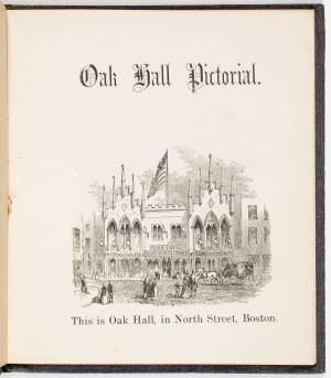
Courtesy American Antiquarian Society, Worcester, Mass. (CL.F9116.011.1854 CL.F9116.011.1854)
Also filed under: Oak Hall »
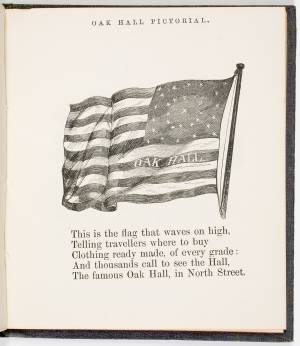
Courtesy American Antiquarian Society, Worcester, Mass. (CL.F9116.011.1854)
Also filed under: Oak Hall »
The Ten Pound Island light was built on a three-and-a-half acre island at the eastern end of Gloucester Harbor. Built as a conical stone tower, the original 20-foot-tall Ten Pound Island Light was first lit in October, 1821 after the Commonwealth of Massachusetts and the Town of Gloucester ceded 1.7 acres to the U.S. Government for the construction of an inner harbor lighthouse to help mariners navigate the harbor. Ten Pound Island light was a popular subject with artists, including Winslow Homer, who boarded with the lighthouse keeper at Ten Pound Island in the summer of 1880. It is frequently featured in Lane's paintings of Gloucester Harbor.
This information has been shared with the Lane project by Jeremy D'Entremont. More information can be found at his website, www.newenglandlighthouses.net or in The Lighthouse Handbook New England. This information has also been summarized from Paul St. Germain's book, Lighthouses and Lifesaving Stations on Cape Ann.

Colored lithograph
Cape Ann Museum Library and Archive
Also filed under: Ten Pound Island »
Photograph
From The Illustrated Coast Pilot with Sailing Directions. The Coast of New England from New York to Eastport, Maine including Bays and Harbors, N. L. Stebbins, 1891.
Also filed under: Ten Pound Island »

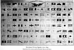
The use of signal flags, for ship-to-ship communication, generally preceded land-based chains of maritime semaphore stations, the latter using flags or rotating arms, until the advent of the electric or magnetic telegraph.
Until the end of the Napoleonic wars, merchant ships generally sailed in convoy as ordered by the escorting warship(s) using a few simple flags. Peace brought independent voyaging, the end of the convoy system, and the realization by various authorities that merchant vessels now needed their own separate means of signaling to each other. This resulted in a handful of rival codes, each with its individual flags and syntax. In general, they each had a section enabling ship identification and also a "vocabulary" section for transmitting selected messages. It was not until 1857 that a common Commercial Code became available for international use, only gradually replacing the earlier ones. All existed side by side for a decade or two.
Signal systems for American ships were originally intended to identify a vessel by name and owner; only later were more advanced systems developed to convey messages. Most basic were private signals, or "house flags", each of a different design or pattern, identifying the vessel's owner; identification charts were local and poorly distributed, limiting their usefulness. A secondary signal, a flag or large pennant bearing the vessel's name, was sometimes flown by larger ships, but pictorial records of them are uncommon. These private signal flags usually flew from the foremasthead or main masthead if a three master ship. Pilot boats had their own identifying flags, blue and white as seen in Spitfire Entering Boston Harbor, n.d. (inv. 536). Small vessels, such as schooners, often had a "tell-tale" pennant, an often-unmarked and often red flag, that was used to determine wind direction.
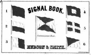
A numerical code flag system, identifying vessels by the code numbers, was introduced by Captain Frederick Marryat R.N. in 1817 for English vessels. American vessels soon adopted this system. Elford's "marine telegraphic system" was the first American equivalent to the Marryat code flags, first issued in 1823, and with changes, remaining in use until the late 1850s. Most of the signal flags on vessels depicted by Lane use Elford's; Brig "Antelope" in Boston Harbor, 1863 (inv. 43) is a noteworthy example of his depiction of Marryat's. The Elford's Code was popular in America on account of its simplicity and only required six blue and white flags. Eventually these changed to red and white, although it is unclear exactly when this happened. Instructions and a key ot the Elford's Code's use are included in successive editions of the Boston Harbor Signal Book.
Whereas the other codes employ at least ten flags of diverse shapes and colours, there are only six Elford flags in total, representing the numbers one to six. All are uniformly rectangular and monochrome in colour (either blue and white or red and white—or even black and white as in an early photograph). Selected from these six flags each individual vessel is allotted a combination of four flags to be prominently displayed as a vertical hoist. Reading from above down these convey its "designated number." Armed with this number and the type of vessel (e.g. ship, bark, brig, schooner /or steamer) the subject can be uniquely identified by reference to a copy of the Boston Harbor Signal Book for the appropriate year.
– A. Sam Davidson
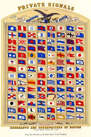
As reproduced in Yankee Sailing Ship Cards by Allan Forbes and Ralph M. Eastman (Boston: State Street Trust Company, 1948).
Also filed under: "Eastern Star" (Bark) » // Forbes, Robert Bennet »
Harvard Depository: Widener (NAV 578.57)
For digitized version, click here.
Also filed under: Boston Harbor »
Boston: Eastburn's Press
New York Public Library
Complete book is included in Google Books, click here.
In The American Neptune 3, no. 3 (July 1943): 205–21.
Peabody Essex Museum
Descriptions of Marryat, Elford, Rogers, and commercial code signal systems, and private signals. Includes illustrations of flag systems with color keys.
Surinam was to Gloucester what China was to Salem, and for the first half of the 19th century Gloucester merchant ships monopolized the trade of exchanging salt fish for molasses. The fish was often of poor quality, destined for the mouths of plantation slaves, but the molasses was rich and dark and a necessary ingredient of the very lucrative New England rum business. The wealth of many of Gloucester’s merchant families was based on this trade.
– Stephanie Buck

Cape Ann Museum Library & Archive
Accounts of voyages, lyceums, meetings, etc:
8. Prepared for company Nancy Elwell, Amelia Annette here to tea Low girls, Eliza Stacy, Maria Rogers in evening with Eben etc. Brother William.
9. Children past the afternoon at Grandma Babsons with a party of little folks - call from C Shaw, Mrs Redding, Nancy, Amelia, Mrs Mary Collins
10. Children went with Mary to see little Amanda - attended Bible Class in eve at Mrs Dales - David quite an ill turn
11. A summer day - Children gone in to show Grandma new books that Father gave them - went back in afternoon with me took tea with Mrs Nancy Davis
12. Delightful weather we have - went up to Mrs Centers found her quite unwell - called into G Saville’s with Esther, Hannah - went into store purchased a piece of beautiful cheese
13. Attended meeting in forenoon heard Mathew H Smith did not go out again - call from Nancy, AK Johnson, Father B
14. Grandma sent down for the children to go out with her - they went and called at Abby Rogers, Mrs Whittemores, Mrs Smiths, Betsey Stevens etc - came home with new books delighted with their walk. E Saville came in with a letter from George S, she stop to tea. MI Lane went with her in eve to call upon Mrs Smith went to Mrs Lowes to communicate news.
15. Went over to Dexters for Mother - into Mrs Rogers - heard of Capt Rowes arrival at Vineyard
16. Attended Society at Mrs Houghs, Lyceum in evening a lecture from Mr. Putnam of Portsmouth not much liked.
17. Perfect day - took the children out over to Cousin Nat’s - into Lucy David - Grandma Bs Mrs F Low - Bible Class at ME Lows
18. Went with mother to Mrs Smith, Mrs Jones, Mrs Pearce - Mother B into stores - Lucy told me she should leave next week.
19. Went over in street with Mother in eve, quit unpleasant - found letter on my return that Capt Rowe carried to Surinam
20. Went to meeting all day and eve. Esther in, hope Capt Fitz will get in soon.
21. Pleasant morn, but bad snow storm afternoon and eve - Lucy left me felt relieved - Dr. Chapman came to see David - still quite sick
22. Lydia Ann Davis here to tea call from Nancy Amelia
Also filed under: Babson, Amanda Stanwood »
Painting on board
72 x 48 in.
Collection of Erik Ronnberg
Chart showing the voyage of the brig Cadet to Surinam and return, March 10–June 11, 1840.
Also filed under: "Cadet" (Brig) » // Brig »
Manuscript
Cape Ann Museum Library and Archive
Also filed under: "Cadet" (Brig) » // Babson, Edward » // Diaries / Ledgers / Etc. »
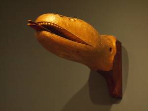
Vessel ornamentation assumed two forms: carvings and color schemes. Carvings, or "ship carvings," as they are called by maritime scholars, are usually crafted in wood and painted or gilt. Many vessels were too small or their owners too frugal to permit carved embellishments, in which cases the enhancement of the vessel's color scheme was a practical alternative. This can be seen in many of the coastal vessels along the new England coast. Pinkies and Chebacco boats had handsome color schemes using only black and green with white sheer lines and limited use of red and yellow. Other combinations of inexpensive pigments were used to improve the simple looks of sloops and schooners in the packet trade, while small pleasure craft and pilot schooners enhanced their appearance in similar ways. Clipper ship owners, finding their vessels' appearance impressive without adding color, settled for unrelieved black hulls. Naval vessels as well preserved their formidable looks with black, relieved only with a white belt in way of the gunports.
The more elaborate ship carvings can be classified in the following categories:
Billetheads: mounted on the bow, at the end of a simple gammon knee, or on the forward end of an elaborate stem-head, they can be scrolls of less or greater intricacy, or sometimes the heads of animals, eagles being the most common. Examples of a sea serpent's head, a pointing hand, and other animal heads have been found. (See Brig "Cadet" in Gloucester Harbor, late 1840s (inv. 13); Brig "Antelope" in Boston Harbor, 1863 (inv. 43); and Brig Off the Maine Coast, 1851 (inv. 241))
Figureheads: mounted on bows of larger vessels, often with elaborate stem joinerwork (trailboards and headboards with associated knees and rails). Usually these were full-length figures representing the ship's owner, a famous citizen, a mythological person or animal, or an eagle. (See Portrait of the "National Eagle", 1853 (inv. 35) (eagle); New York Harbor, c.1855 (inv. 46); The "Britannia" Entering Boston Harbor, 1848 (inv. 49) (female figures); The Ships "Winged Arrow" and "Southern Cross" in Boston Harbor, 1853 (inv. 54) (dragon and eagle); "Starlight" in Harbor, c.1855 (inv. 249) (dragon); and Steam demi bark Antelope, 615 tons, c.1855 (inv. 375) (antelope))
Trailboards: carved vines or scrollwork abaft the figurehead which trail aft along the stem head in a graceful descending arc, terminating at the hawse pipes. They are usually gilt and frequently ornamented with carved rosettes and other devices. (See Brig "Cadet" in Gloucester Harbor, late 1840s (inv. 13); Portrait of the "National Eagle", 1853 (inv. 35); Brig "Antelope" in Boston Harbor, 1863 (inv. 43); New York Harbor, c.1855 (inv. 46); and The Ships "Winged Arrow" and "Southern Cross" in Boston Harbor, 1853 (inv. 54))
Headboards: boards mounted to headrails connecting the figurehead to the ship's mainrail at the catheads. While seldom given any decorative carvings, the vessel's nameboards were often mounted to them. (See Brig "Cadet" in Gloucester Harbor, late 1840s (inv. 13); Portrait of the "National Eagle", 1853 (inv. 35); Brig "Antelope" in Boston Harbor, 1863 (inv. 43); The Ships "Winged Arrow" and "Southern Cross" in Boston Harbor, 1853 (inv. 54); Clipper Ship "Southern Cross" in Boston Harbor, 1851 (inv. 253); and Mary Ann, 1846 (inv. 309))
Catheads: Carved lion heads mounted on the outboard ends of the cathead knees. This term is so archaic that the knees and carvings are treated as one and the same, as in their use, i.e. "catting the anchor" (securing the anchor ring to the cathead). (See Brig "Antelope" in Boston Harbor, 1863 (inv. 43); and An American Frigate Hove-to Off the New England Coast, n.d. (inv. 535))
Quarterboards: Name boards mounted to the vessel's side near the stern, they usually had ornamental edge moldings and sometimes stars or simple scrollwork at each end of the name. (See Portrait of the "National Eagle", 1853 (inv. 35); Mary Ann, 1846 (inv. 309); and Spitfire Entering Boston Harbor, n.d. (inv. 536))
Transom arches: arch-form panels fitted to the transom, often over gallery lights (windows) or other carvings. They usually have edge moldings, decorative scrollwork, and sometimes a bust or other carved figure at the center.
Other transom carvings: carved eagles, busts, scrollwork and coats of arms can occupy the space between the transom arch and the sternboard. If galleries are present, carved scrollwork may be fitted between the frames of the gallery lights. (See Boston Harbor, c.1850 (inv. 48); The Topsail Schooner "Kamehameha III" in Boston Harbor, 1846 (inv. 301) (eagle); Baltimore Harbor, 1850 (inv. 400) (eagle); and (eagle and flags))
Sternboard: often the bottom plank of the transom on which the vessel's name is carved or painted, seldom with decoration (stars or scrollwork). There is usually simple protective molding above and below the lettering.
Sideboards, or gangway boards: boards on either side of an entry way at main rail level on a large ship, usually between the main and mizen masts. They are carved and painted or (if of fine hardwood) varnished. Most commonly seen on larger vaval vessels, packet ships, and clipper ships.
– Erik Ronnberg
References:
1. Brewington, M. V., Shipcarvers of North America, (Barre, MA: Barre Publishing Co., 1962).
2. The American Neptune, Pictorial Supplement XIX, "The Art of the Shipcarver" (Salem, MA: The Peabody Museum, 1977).
3. Ship Figureheads (Boston: State Street Trust Co., n.d.).
4. Edouard A. Stackpole, Figureheads & Carvings at Mystic Seaport (Mystic, CT: The Marine Historical Association, Inc., 1964).
Carved wood with paint and gilt
12 x 22 x 8 in.
Cape Ann Museum. Gift of George W. Woodbury, 1936 (747)
This sea serpent billet head came from the schooner "Diadem" which was built in Essex, Massachusetts, in 1855 and owned by D. Elwell Woodbury and John H. Welsh of Gloucester.
Sea serpents were reportedly sighted here on Cape Ann from colonial times through the mid-nineteenth century. In 1817, more than 50 people, many of them prominent members of the community, reported seeing a serpent in the waters of Gloucester Harbor just off Pavilion Beach. So credible were the reports that the Linnaean Society of New England collected depositions from witnesses and published their findings in a small pamphlet entitled Report of a Committee of the Linnaean Society of New England relative to a Large Marine Animal Supposed to be A Serpent, seen Near Cape Ann, Massachusetts, in August 1817.
Also filed under: Objects » // Pavilion (Publick) Beach »
Edward Babson (February 18, 1811–November 27, 1879) was one of Gloucester’s most successful Surinam trading captains. He was the owner of the brig "Cadet," the subject of Lane's portrait, Brig "Cadet" in Gloucester Harbor.
Edward was the third son of the eight surviving children (five boys and three girls) of William Babson and his first wife Mary Griffin. Annette Babson was Edward's sister. One of Edward’s older brothers was John James Babson, the author of History of the Town of Gloucester, Cape Ann, first published by Procter Brothers in 1860. It remains the definitive history of pre-Civil War Cape Ann.
Edward’s father, William Babson, was a Gloucester maritime merchant with a store on Front Street who also, between 1808 and his death in 1848, owned, or part-owned, a sloop, eight schooners, a ship, and two brigs, one of which was the "Cadet."
Edward first went to sea at the age of thirteen on his father’s three-masted ship "Shylock." By the time of his marriage to Amanda Stanwood on November 12, 1833, Edward had already earned the title of captain and was a seasoned mariner, having voyaged to the East Indies, South America and the Mediterranean.
By 1836, Edward and his brother John James had become co-owners of the brig "Cadet," and for the next decade, Edward sailed her back and forth to South America. Surinam was to Gloucester what China was to Salem, and for the first half of the nineteenth century, Gloucester merchant ships monopolized the trade of exchanging salt fish for molasses. The fish was often of poor quality, destined for the mouths of plantation slaves, but the molasses was rich and dark and a necessary ingredient of the very lucrative New England rum business. The wealth of many of Gloucester’s merchant families was based on this trade.
Each trip took an average of four months, with twenty-three days at sea each way and a stop-over in Surinam that could last up to ten weeks. Time ashore was spent selling and unloading the incoming cargo, making necessary repairs to the ship, and purchasing the outgoing cargo. Edward was a very competitive sailor and took great pride in making his time at sea as short as possible, even entering the number of days each one took in his log. He also commented on other vessels and captains both faster and slower than his—once ruefully noting that his brother-in-law beat him home by six days.
Paramaribo, the capital of Surinam, was a cosmopolitan city with trading ships from all over the world sailing in and out, and Edward’s cargo reflected this. His account book for January 27, 1838 shows that on this trip, twenty-five percent of his revenue came from salt fish, with flour coming in a close second. The rest, amounting to just over half his sales, was in boxes of candles (spermaceti and beeswax) and Havana cigars, barrels of beef, salmon, pork, tobacco (some of which, he noted, was unfortunately damaged), and wine. There were also small kegs, bottles and boxes of oil, lard, cheese, raisins, and navy bread; over a thousand feet of lumber, ten dozen chairs, and a wherry that he sold for fifteen guilders.
Edward Babson's wife, Amanda, was the daughter of another well-placed captain, Richard Goss Stanwood and his second wife Hannah Harraden. Richard Stanwood also owned several vessels, one of which was the ship "Mount Wollaston," which he and six others purchased, refitted, and sent to the South Atlantic on a whaling voyage. Just before her marriage, Amanda wrote to her brother—who was away at sea himself—“We only see [father] at meal times and then he scarcely gives himself time to eat, he is so wholly devoted to the Mount Wollaston. We shall be rejoiced when the ship is gone for if it stays here much longer I should not wonder if father turned into a whale.” (1)
During the years of Edward's trips to South America, he and Amanda reared five children, living first on Front Street (now Main Street), and before purchasing the Charles H. Hovey estate on Summer Street, shared Amanda's brother Solomon Stanwood’s house. The Hovey estate was in what was a comparatively secluded rural area of town at the time. Edward later developed this area—known colloquially as “Babson Hill”—building tenement houses and selling off house lots.
In 1846, at the age of thirty-five, Edward retired from the sea, a wealthy merchant and the owner of more than eight ships. Although he continued to live in Gloucester, he had offices in Boston where he engaged in trade with, among other places, Valparaiso, Chile and San Francisco, California. In Gloucester, he was a member of the Board of Trustees of Oak Grove Cemetery, a director of the Gloucester Bank (which his grandfather had co-founded), and a staunch Universalist.
Edward and Amanda's children were: Hannah (December 7, 1834–September 2, 1909), who never married; Amanda (April 6, 1836–August 4, 1889), who married Edwin Hervey Davis; Edward (September 20, 1839–July 26, 1880), who married Harriet Chapin Rice; Francis H. (November 19, 1843–January 16, 1904), who never married; and Isabella (September 14, 1848–February 16, 1917), who married Gustavus A. Lane.
Amanda died on May 6, 1857 at the age of forty-six. Two years later, on June 8, 1859, Edward married twenty-five year old Julia Friend, daughter of George and Mary (Sayward) Friend. George Friend was another vessel-owning merchant in town and a deacon of the Universalist Church. Edward and Julia had two children: Fanny Gilmore (March 9, 1860–April 28, 1892), after whom Edward named one of his schooners, and George (January 19, 1862–March 4, 1890). Neither of them ever married.
– Stephanie Buck (February, 2014)
(1) Amanda Stanwood Letters, Cape Ann Museum, Box P30A FF03.
Cape Ann Library & Museum
"The Post Office looked very pretty indeed; it was done under the direction of Mr. Lane. The words at the top were made so as to appear transparent, and at the top of all was an eagle, with a wreath of flowers hanging down from its mouth, and encircling the letters. The hall was hung with colors
in festoons..."
Also filed under: Gloucester Community / Participation / Other projects »

Cape Ann Museum Library and Archive
Accounts about the Blizzard of 1839:
15. Storm commenced last night—extremely pleasant all day till evening it increased and so continued thro’ this day with violence. never did I pass a more gloomy Sabbath. Fuller came in after tea wet through. he had been down to the wharfs and other places three four hours. he says it is dreadful storm and what makes it the worse people are drowning and no assistance can be rendered them the storm is raging so violent -
16. storm has abated some, and men are flocking by to assist the sufferers. many vessels ashore at the cove, steep rock and many of the men drowned. one woman found—and two women they dragged on shore alive and not much hurt—oh heavens what a storm this has been and how much distress it has brought. I hope Capt. Nickerson is safe if he came out of the Vineyard Saturday I fear he may not have reached the city before the storm came on. Father has been down to cove all day. he says it is a most dreadful sight.
17. pleasanter. had a meeting of the inhabitants last night and subscribed 4 or 5 hundred dollars for the poor shipwrecked mariners. poor souls how much they have suffered. many bodies have been found .
20. Mr Whaite is to preach the funeral sermon Sunday as the men will be buried from his church and Mr Smith delivers the prayers. there are 11 bodies.
27. oh what a night I past. the wind blew a hurricane worse than before—was up some time before light for it was impossible to sleep or feel easy
28. Miss Wharf came to help me try out my larder. a brig went all to pieces this morning about 4 o’clock in about the same place the others did. all on board was saved except the Captains Wife—three other vessels ashore at half moon beach—it has been a gloomy month . . .
Also filed under: Babson, Amanda Stanwood » // Blizzard of 1839 » // Diaries / Ledgers / Etc. »
Transcription by Stephanie Buck.
Cape Ann Museum Library and Archive
Also filed under: "Cadet" (Brig) » // Babson, Amanda Stanwood » // Diaries / Ledgers / Etc. »

Cape Ann Museum Library and Archive
Accounts of parties, etc.:
4. Passed one of the gloomiest days possible entirely alone with my little girls all day - Mother and the children - David and his family having gone to Essex to pass the day and Richard, Hannah at a party on the water, thought much of my dear E - had several crying spells hoped that E passed it more pleasantly in Surinam if he had arrived and I hope sincerely he had.
5. Invited at Emmeline’s to tea went at 1⁄2 past 5 found quite a party assembled - Capt. Elwell arrived home just as I got there - quite a joyful meeting he seemed very well and happy at returning once again to his family - seemed to feel a good deal at the loss of his mate Mr. Allen who was washed overboard. He had not been married long to Miss Leach, D & L sister - she has not had her senses since she heard of it till the last week. Very many shower thunder and lightning. I left the party and came home for I shld not be content away from my children in such a shower.
9. Expected Aunt Stacy to pass the day with me did not come till afternoon accompanied by Mary and babe - Capt. Elwell left - Solomon to sail in a few days - walked round town with Aunt S and left her at Mother B’s gave her 5 dollars thinking that Edward would do so if at home - she seemed very grateful for it - shed tears.
7. Delightful morn and my birthday - expect dear E will think of me today - look back with gratitude and thankfulness to the past year, for the health of my children and husband and the great happiness I have enjoyed I cannot be too thankful and trust the ensuing year will be attended with as much happiness - Cousin David Harraden came to pass a few days in town was happy to see him and invited him to spend his time here.
8. Attended meeting all day heard Mr Faye - found him quite tedious - went to walk in evening - several called in as they returned.
9. Invited to a party at Bass Rocks - declined going as the heat was excessive thermometer at 96 in the shade. Richard and Cousin D went around the Cape - stopped at Ann Norwood- tuned her piano. R was delighted with her. Went up to mother B’s in evening heard some fine singing and playing from David, Mrs Shipley, Clem Low - returned found people singing in Mrs Lows yard- joined them - was delighted at the performance W Dale, C Presson, Cousin D and Mrs Shipley sang many beautiful pieces.
10. Richard, Brother D and Cousin D went fishing - invitation to visit Aunt Haraden and C. Dolliver went down to Aunts to tea and Clem in the eve - had pleasant visit
Also filed under: Babson, Amanda Stanwood »
Also filed under: "Cadet" (Brig) » // Diaries / Ledgers / Etc. »
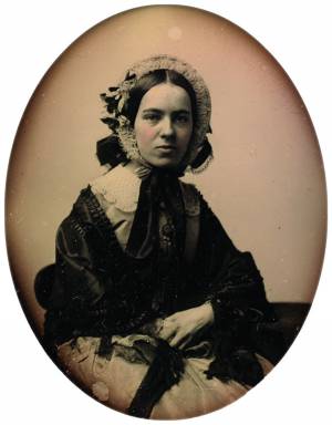
Daguerreotype of Amanda Stanwood Babson (1811–1857)
Collection of the Cape Ann Museum.
Also filed under: Babson, Amanda Stanwood »
Manuscript
Cape Ann Museum Library and Archive
Also filed under: "Cadet" (Brig) » // Diaries / Ledgers / Etc. » // Surinam Trade »
Oil on canvas
27 x 34 in.
Cape Ann Museum, Gloucester, Mass.
Edward Babson was master of the brig "Cadet" at the time when Lane painted the vessel’s portrait.
Also filed under: "Cadet" (Brig) »