An online project under the direction of the CAPE ANN MUSEUM
Low (David) House
View related Fitz Henry Lane catalog entries (3) »
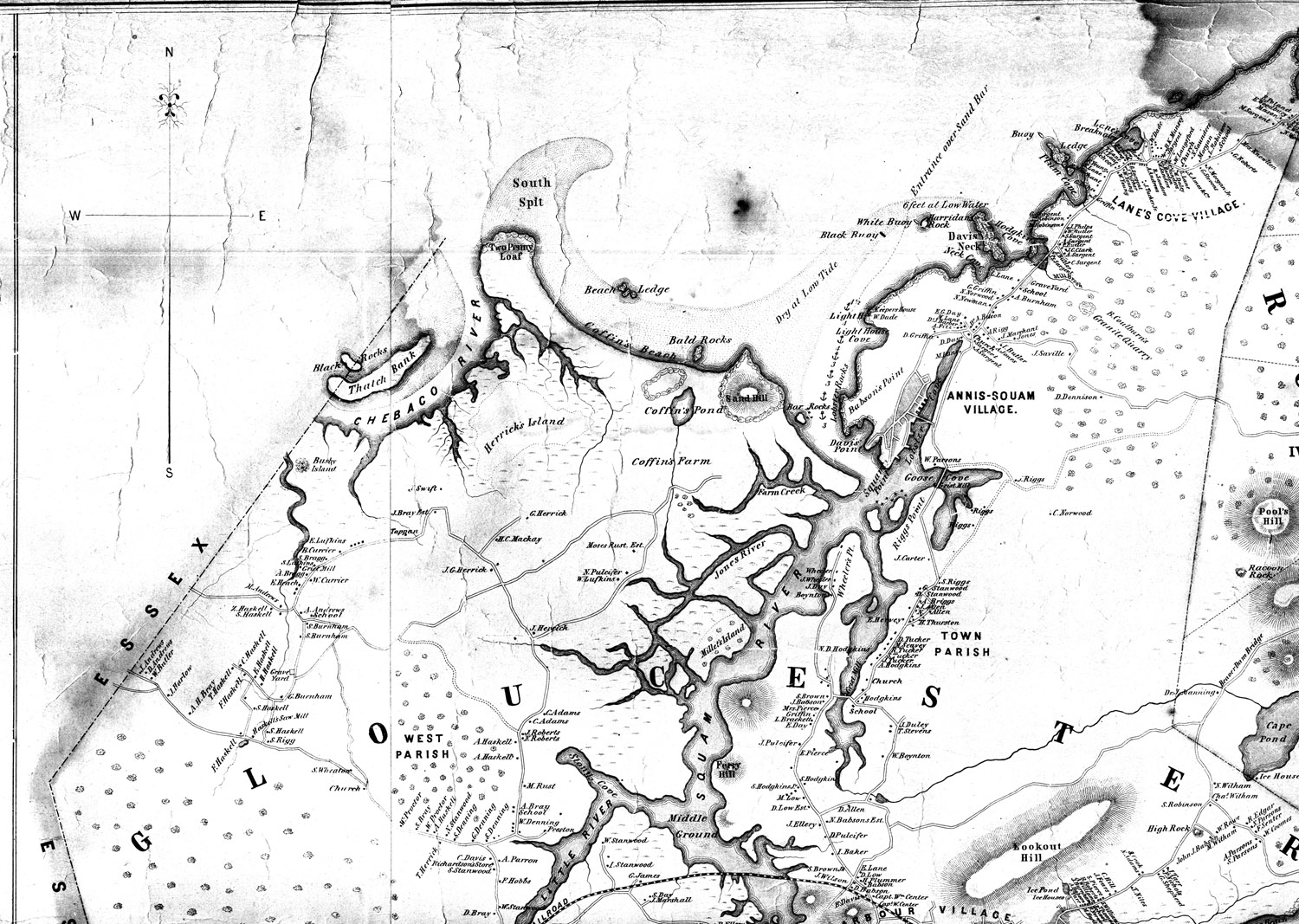
The David Low house appears in Lane's Babson and Ellery Houses, Gloucester, 1863 (inv. 10); it was located near the current corner of Washington Street and Cunningham Road. The roof and chimney peek up over the hill and field at the far left of canvas, above the man in the gundalow. It no longer exists, but it stood where Cunningham Road now leaves Washington Street, between Grant Circle and Addison Gilbert Hospital.
David Low, the son of John Low Jr. and Sarah "Gee," was born in 1759. He married Elizabeth Rogers in 1786 and they had fourteen children. By 1863, both David Low and Elizabeth were dead, but three of their daughters inhabited the house. It was these three sisters, Mary, Lucy and Sally/Sarah Low, about whom Lane's posthumous promoter, Alfred Mansfield Brooks, wrote, referring to them as the sisters of Captain Gorham Low:
"The Low house was a three-story Federal in which each sister occupied a floor wholly her own except for the parlor, which was reserved for callers, tea parties and funerals. A fine Copley portrait hung in this parlor, and Grandmother remembered how it was always rubbed over with a rind of fresh pork to make it shine when company was expected. I was taken in and shown as 'Abby's boy,' which I hated, and then expected to sit silent during each of the three visits, which I hated even more. Precisely the same length of time to the minute was exacted by the old ladies, else, as Great-Aunt Sarah said, they would never overlook the slight."
In the early twentieth century, after the deaths of the sisters, the house left the Low family and was owned by Edith and then Florence Cunningham, but was eventually torn down to allow for the creation and development of Cunningham Road in the 1950s.
– Sarah Dunlap (September, 2013)
Related tables: Low, Colonel David »

Cape Ann Museum Library & Archive
Grayscale version of color original
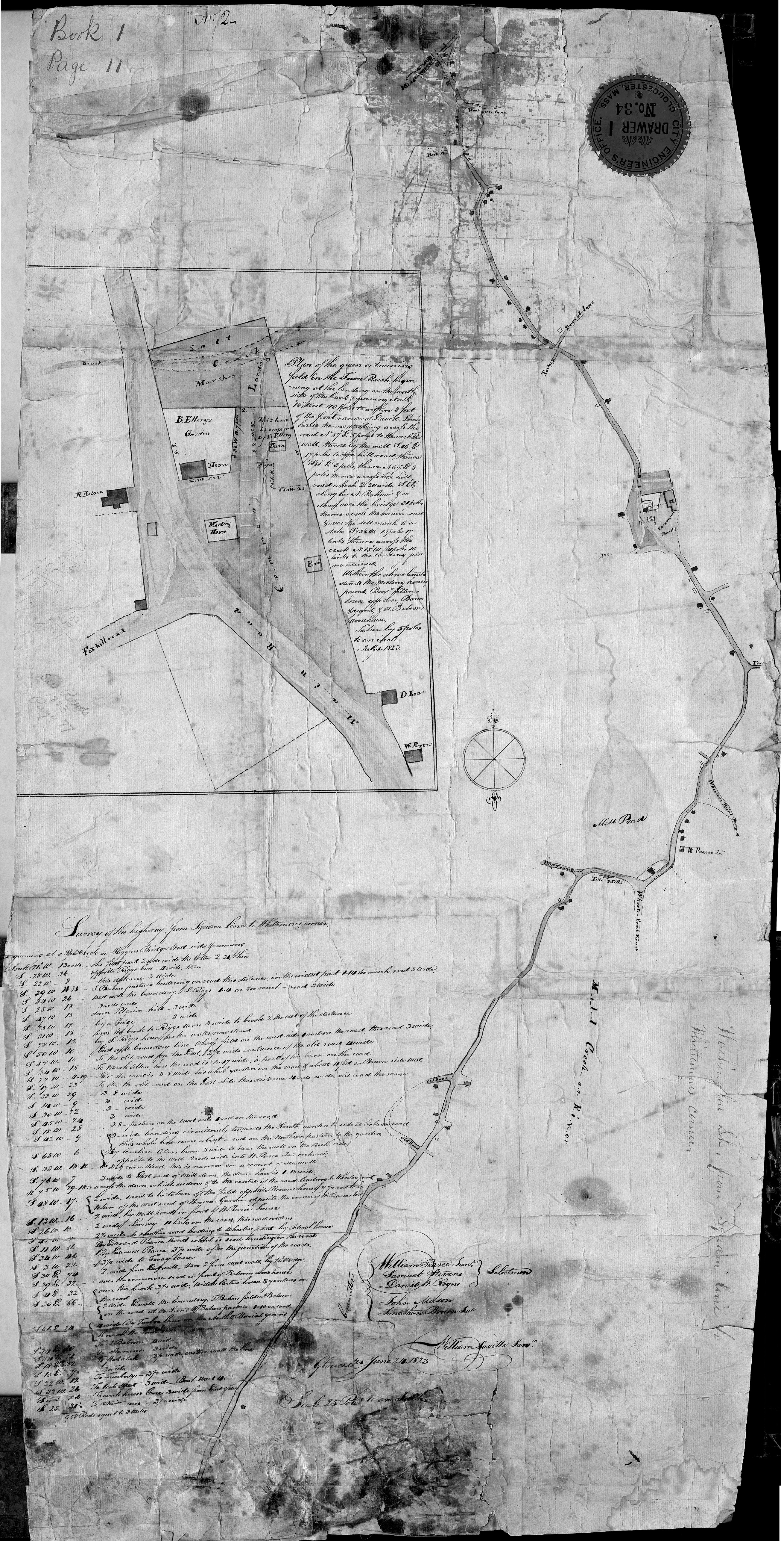
Map of Riverdale from the Mills to the Whittemore House at Middle and Washington Streeets ordered by a committee of selectmen, William Pearce, Samuel Stevens, Daniel H. Rogers with John Mason and Anthony Presson. Map drawn by surveyor William Saville and present to the committee in June, 1823. It contains a enlarged view of The Green, including the Ellery and Babson houses painted by Lane.
Also filed under: Babson House » // Maps » // Meetinghouse Green » // Riverdale / Town Parish » // Riverdale Mills »
44 x 34 in.
Henry Francis Walling, Map of the Towns of Gloucester and Rockport, Essex Co. Massachusetts. Philadelphia, A. Kollner, 1851
Cape Ann Museum Library & Archive
"Map of the Towns of Gloucester and Rockport, Massachusetts. H.F. Walling, Civil Engineer. John Hanson, Publisher. 1851. Population of Gloucester in 1850 7,805. Population of Rockport in 1850 3,213."
View related Fitz Henry Lane catalog entries (1) »
Also filed under: Annisquam River » // Babson House » // Coffin's Beach » // Eastern Railroad » // Gloucester, Mass. – Annisquam Harbor Lighthouse » // Granite Quarrying / Shipping » // Loaf, The » // Maps » // Old First Parish / Subsequent Fourth Parish Church (at the Green) » // Riverdale Methodist Church (Washington Street) » // White-Ellery House »