An online project under the direction of the CAPE ANN MUSEUM
Catalogue Entry
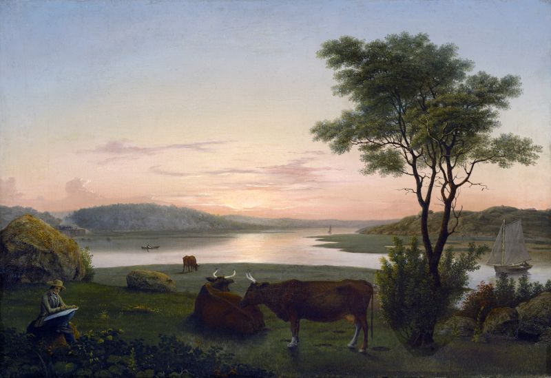
This painting is one of several works Lane made of the area known as "Done Fudging." Fudging referred to the poling of a vessel in the tidal river (where the thick mud is reminiscent of chocolate fudge), and Done Fudging was the point at which one was "done fudging." This version of the scene is unusual for the figure in the lower left, believed to be a rare self-portrait of Lane, and for the depiction of the train in the background. The Eastern Railroad branch line had just been extended to Gloucester in 1848, making the transport of goods and people to and from Boston rapid and inexpensive. The drawing Westward View from Cove near Done Fudging, 1861 (inv. 117) is very similar in composition, which suggests that it was a study after which Lane made the painting, although the drawing has traditionally been given a later date.
Historical Materials
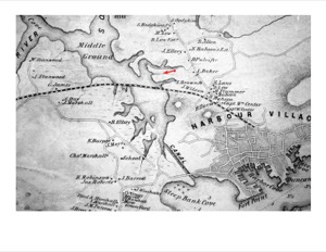
The construction of the Gloucester branch of the Eastern Railroad from Salem in 1848 transformed Cape Ann from a sleepy rural area to a bustling metropolis, with summer visitors from Boston and New York arriving daily and tons of fish and other goods being shipped back and forth to and from points west. New England Inlet with Self-Portrait, 1848 (inv. 77) shows the train, but it is omitted in two sketches of the area. The 1834–35 Mason map notes that John Mason sold a large area of land to the railroad company in 1845.
Cape Ann Museum Library & Archive
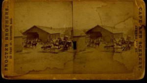
Stereograph card of Eastern Railroad Depot with 9:30 up train, August 11, 1874.
Also filed under: Historic Photographs »

1834–35 24 x 38 in. Gloucester City Archives
"Drawn on a scale of one hundred feet to an inch. By John Mason 1834–45 from Actual Survey showing every Lott and building then standing on them giving the actual size of the buildings and width of the streets from the Canal to the head of the Harbour & part of Eastern point as farr as Smith's Cove and the Shore of the same with all the wharfs then in use. Gloucester Harbor 1834–35."
This map is especially helpful in showing the wharves of the inner harbor at the foot of Washington Street.
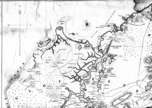
1851 44 x 34 in. Henry Francis Walling, Map of the Towns of Gloucester and Rockport, Essex Co. Massachusetts. Philadelphia, A. Kollner, 1851 Cape Ann Museum Library & Archive
"Map of the Towns of Gloucester and Rockport, Massachusetts. H.F. Walling, Civil Engineer. John Hanson, Publisher. 1851. Population of Gloucester in 1850 7,805. Population of Rockport in 1850 3,213."
Also filed under: Annisquam River » // Babson House » // Coffin's Beach » // Gloucester, Mass. – Annisquam Harbor Lighthouse » // Granite Quarrying / Shipping » // Loaf, The » // Low (David) House » // Maps » // Old First Parish / Subsequent Fourth Parish Church (at the Green) » // Riverdale Methodist Church (Washington Street) » // White-Ellery House »
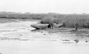
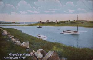
Technically not a river but a saltwater tidal estuary, the Annisquam (or "Squam") River almost cuts off Cape Ann from the rest of the world. Its constantly flowing tides, and the gleaming expanse of marshes surrounding it, inspired several of Lane's paintings. Marsh hay was harvested along its tidal inlets and provided subject matter for Lane's depiction of this ancient occupation, and the traditional craft associated with it, the gundalow. The Annisquam is connected to Gloucester Harbor by The Cut, also known as the Blynman Canal, which was first dug in the seventeenth century, filled in and opened again to complete the more direct inland passage between the harbor and open ocean.
4 x 5 in.
Cape Ann Museum Library & Archive
#10159
Rare view of a marsh gundalow, being used on the Annisquam River for harvesting salt marsh hay.
Also filed under: Gundalow / Scow »
1851 44 x 34 in. Henry Francis Walling, Map of the Towns of Gloucester and Rockport, Essex Co. Massachusetts. Philadelphia, A. Kollner, 1851 Cape Ann Museum Library & Archive
"Map of the Towns of Gloucester and Rockport, Massachusetts. H.F. Walling, Civil Engineer. John Hanson, Publisher. 1851. Population of Gloucester in 1850 7,805. Population of Rockport in 1850 3,213."
Also filed under: Babson House » // Coffin's Beach » // Eastern Railroad » // Gloucester, Mass. – Annisquam Harbor Lighthouse » // Granite Quarrying / Shipping » // Loaf, The » // Low (David) House » // Maps » // Old First Parish / Subsequent Fourth Parish Church (at the Green) » // Riverdale Methodist Church (Washington Street) » // White-Ellery House »
1870s Stereograph card Cape Ann Museum Library & Archive
Also filed under: Historic Photographs »

44 x 34 in.
Henry Francis Walling, Map of the Towns of Gloucester and Rockport, Essex Co. Massachusetts. Philadelphia, A. Kollner, 1851
Cape Ann Museum Library & Archive
"Map of the Towns of Gloucester and Rockport, Massachusetts. H.F. Walling, Civil Engineer. John Hanson, Publisher. 1851. Population of Gloucester in 1850: 7,805. Population of Rockport in 1850: 3,213."
Also filed under: Brookbank » // Dolliver's Neck » // Fresh Water Cove » // Gloucester Harbor, Outer » // Maps » // Norman's Woe » // Stage Rocks / Stage Fort / Stage Head » // Steepbank » // West Gloucester – Little River » // Western Shore »
Also filed under: Davis' Neck »
Postcard
Cape Ann Museum Library & Archive
Also filed under: Riverdale / Town Parish »
Survey of the Coast of the United States, Washington, D.C.
Collection of Erik Ronnberg
Also filed under: Maps »
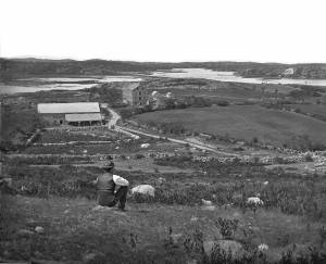
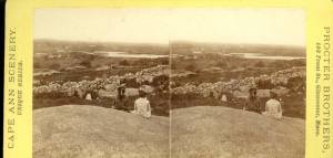
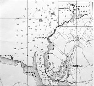
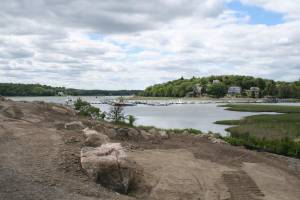
Done Fudging (or "Done Fudgin'" or "Dunfudgin'") refers to an area along the Annisquam River, just west of the old Meetinghouse Green. It is now the heavily trafficked site of Grant’s Circle, the first rotary in Gloucester after crossing the Route 128 bridge. It was an area central to transportation in Lane’s time, as it is now. Washington Street came to it from the harbor, traversed the Green, and headed north to Riverdale and Annisquam. The train tracks from Boston crossed the Annisquam River at this point after running along the side of the river, initially on a trestle and later on an earth embankment still in use today. There was a town landing for boats that landed all manner of goods and people moving up and down from Annisquam and Ipswich Bay or crossing onto Cape Ann from West Gloucester.
The name refers to the poling of river craft often necessary in the narrow river because of unfavorable wind or tidal flow. It’s a muddy bottom all along the Annisquam River, and poling a boat was called "fudgin'." There is a strong tidal current coming from both directions, from the south and Gloucester Harbor through the Cut and down the river from Ipswich Bay to the north. The tidal flows meet at Done Fudging. If you were “fudgin'” south against the tide draining into Ipswich Bay, when you reached the area of Done Fudging, the draining tide would change direction and carry you effortlessly out to Gloucester Harbor. Or vice versa, either way when you reached that point you were “done fudgin'." The river also broadens out at this point so at a full tide with a decent wind, sails could be raised and the fudgin’ poles put away, at least for a while.
Lane drew and painted a number of pictures from this spot. It must have been relatively easy for him to get there by carriage from the harbor. One of his early residences, Whittemore House on Washington Street, was only a half mile or so away. In contrast to the constant bustle of the harbor, Done Fudging was a peaceful and verdant place. The small farms with their trees and meadows stretched along both sides of Washington Street, while the salt marsh running along the Annisquam River went from emerald green in summer to gold in fall and brown in winter.
Lane did several views looking west upriver from Done Fudging, such as Looking up Squam River from Done Fudging, 1850s (inv. 26). The two most intriguing are nearly identical and include apparent self portraits of the artist (one with crutches, one without) sitting on a rock and drawing the river scene in the company of several large cows (see New England Inlet with Self-Portrait, 1848 (inv. 77)).
Today, the public landing at Done Fudging is one of the City of Gloucester’s most popular and heavily used public landings. It is located adjacent to Gloucester High School and has a small boat launching ramp which is accessed by a paved road.
Newspaper clipping
Cape Ann Advertiser
Collection of Fred and Stephanie Buck
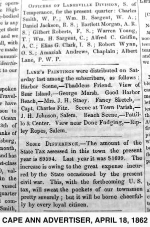
"LANE'S PAINTINGS were distributed on Saturday last among the subscribers, as follows: Harbor Scene, – Thaddeus Friend. View of Bear Island, – George Marsh. Good Harbor Beach, – Mrs. J. H. Stacy. Fancy Sketch, – Capt. Charles Fitz. Scene at Town Parish, – J. H. Johnson, Salem. Beach Scene, – Pattillo & Center. View near Done Fudging, – Ripley Ropes, Salem."
Also filed under: Alex Patillo Dry Goods » // Baptist Church (Old, First, 1830) (Pleasant Street) » // Center & Co. » // Center, Henry » // Fitz, Capt. Charles » // Friend, Thaddeus » // Johnson, J. H. » // Marsh, George » // Newspaper / Journal Articles » // Patillo, Alex » // Ropes, Ripley » // Stacy, Mr. and Mrs. John Hancock »
Digital photograph
Martha Oaks
View related catalogue entries (2) »
Also filed under: Site Photographs »
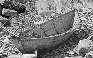
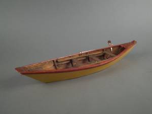
The term “wherry”—variously spelled—has a long history with many hull types, some dating from the fifteenth century. (1) The version known to Lane appears to be a variant of the dory hull form and probably was developed by French and English fishermen in the Newfoundland fisheries before 1700. (2) From that time, the wherry and the dory co-evolved, their similarities the result of their construction, their differences the result of use. By the early nineteenth century, their forms reached their final states, if fragments of contemporary descriptions are any indication. (3)
By the time Lane was depicting wherries, the type (as used for fishing) resembled a larger, wider version of a dory. The extra width was due to greater bottom width (both types had flat bottoms), with a wider transom at the stern instead of the narrow, v-shaped “tombstone.” These features are easy to see in one of his drawings (see Three Men, One in a Wherry, n.d. (inv. 225)) and a painting (see Sunrise through Mist, 1852 (inv. 98)), the latter depicted alongside a dory, clearly showing the differences.
No published descriptions of the uses of wherries on Cape Ann in Lane’s time have come to light, but an example in broadside view offers one use. In Becalmed Off Halfway Rock, 1860 (inv. 344), a pinky (in right foreground) has a dory and a wherry in tow, the latter loaded with a gill net for catching mackerel. (4) The greater size of the wherry is required for stowing the net, as well as setting it while the dory tows away one end to set it in way of the mackerel school.
In Lane’s time, wherries would have been used where bulky gear was called for in the coastal fisheries, i.e. gill nets, and fish traps such as pound nets, fyke nets, and lobster traps. Migrating fish schools (herring, mackerel) and shellfish were the target species.
The dory’s development was first dictated by its use in shore fishing, where small size and light weight made it easy to maneuver around rocks and shallows, and to haul ashore at the end of a day’s work. Its simple design made it easy and cheap to build. This is borne out by the standardized construction and sizes used by Simon Lowell’s boat shop at Salisbury Point, Massachusetts at the turn of the nineteenth century. Lowell called his boats “wherries,” but in Swampscott, Massachusetts, the fishermen, who used them called them “dories,” which may mark the beginning of the latter term’s wider use. (5)
The dories we see in Lane’s paintings are in virtually every way like the ones we know today. One of the best examples (see View from Kettle Cove, Manchester-by-the-Sea, 1847 (inv. 94)) even shows interior detail, including frames, leaving no doubt about its construction. Other good examples are found in Salem Harbor, 1853 (inv. 53), View of Gloucester Harbor, 1848 (inv. 97), and Sunrise through Mist, 1852 (inv. 98).
For inshore fishing, dories were used to catch mackerel and herring, either with hook and line or with small nets. Hooks and line were used for flat fish (flounder, dab, and fluke), rock cod, hake, and cunner. Eels were speared (see View from Kettle Cove, Manchester-by-the-Sea, 1847 (inv. 94)), clams were dug, and lobsters trapped. In Lane’s later years, the use of dories in trawling (setting long “trawl lines” with many baited hooks) was in its earliest. This method required six to ten dories carried on board a schooner to fish on the distant banks off New England and Canada. Early records of dory trawling in New England are fragmentary, giving the mid-1840s as the time of introduction. (6) The Gloucester-owned schooner "Anna" made a successful dory trawling trip to the Grand Banks in 1854, but no depiction of this vessel by Lane has been found or recorded. (5) Despite successful early efforts, dory trawling from Gloucester was slow to be accepted, and the fishery had very limited growth prior to 1860. (7)
– Erik Ronnberg
References:
1. M.H. Parry et al., Aak to Zumbra (Newport News, VA: The Mariners’ Museum, 2000), 634.
2. John Gardner, The Dory Book (Camden, ME: International Marine Publishing Company, 1978), 5–9.
3. Ibid., 25–29.
4. John Wilmerding, ed., Paintings by Fitz Hugh Lane (Washington, DC: National Gallery of Art, 1988), 89, 92. The “possibly discarded whaleboat” is definitely a wherry.
5. Gardner, 9, 10.
6. Wesley George Pierce, Goin’ Fishin’ (Salem, MA: Marine Research Society, 1934), 63–64.
7. Raymond McFarland, A History of New England Fisheries (Philadelphia: University of Pennsylvania, 1911), 279.

c.1870 Stereograph card Procter Brothers, Publisher Cape Ann Museum Library & Archive
"Gloucester Harbor from Rocky Neck, Looking Southwest. This gives a portion of the Harbor lying between Ten Pound Island and Eastern Point. At the time of taking this picture the wind was from the northeast, and a large fleet of fishing and other vessels were in the harbor. In the range of the picture about one hundred vessels were at anchor. In the small Cove in the foreground quite a number of dories are moored. Eastern Point appears on the left in the background."
Southeast Harbor was known for being a safe harbor.
Also filed under: Gloucester Harbor, Outer » // Historic Photographs » // Rocky Neck » // Schooner (Fishing) »
Also filed under: Chebacco Boat / Dogbody / Pinky » // Ship Models »
Gloucester, MA
4 x 33 1/2 x 7 1/4 in (10.16 x 85.09 x 18.415 cm)
Peabody Essex Museum
Also filed under: Objects » // Ship Models »
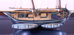
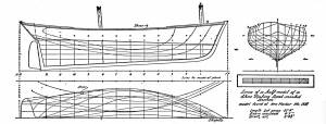
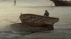
The yawl boat was a ninteenth-century development of earlier ships' boats built for naval and merchant use. Usually twenty feet long or less, they had round bottoms and square sterns; many had raking stem profiles. Yawl boats built for fishing tended to have greater beam than those built for vessels in the coastal trades. In the hand-line fisheries, where the crew fished from the schooner's rails, a single yawl boat was hung from the stern davits as a life boat or for use in port. Their possible use as lifeboats required greater breadth to provide room for the whole crew. In port, they carried crew, provisions, and gear between schooner and shore. (1)
Lane's most dramatic depictions of fishing schooners' yawl-boats are found in his paintings Gloucester Outer Harbor, from the Cut, 1850s (inv. 109) and /entry:311. Their hull forms follow closely that of Chapelle's lines drawing. (2) Similar examples appear in the foregrounds of Gloucester Harbor, 1852 (inv. 38), Ships in Ice off Ten Pound Island, Gloucester, 1850s (inv. 44), and The Fort and Ten Pound Island, Gloucester, Massachusetts, 1847 (inv. 271). A slightly smaller example is having its bottom seams payed with pitch in the foreground of Gloucester Harbor, 1847 (inv. 23). In Gloucester Inner Harbor, 1850 (inv. 240), a grounded yawl boat gives an excellent view of its seating arrangement, while fishing schooners in the left background have yawl boats hung from their stern davits, or floating astern.
One remarkable drawing, Untitled, n.d. (inv. 219) illustrates both the hull geometry of a yawl boat and Lane's uncanny accuracy in depicting hull form in perspective. No hull construction other than plank seams is shown, leaving pure hull form to be explored, leading in turn to unanswered questions concerning Lane's training to achieve such understanding of naval architecture.
– Erik Ronnberg
References:
1. Howard I. Chapelle, American Small Sailing Craft (New York: W.W. Norton & Co., 1951), 222–23.
2. Ibid., 223.
Oil on canvas
12 1/8 x 19 3/4 in.
Museum of Fine Arts, Boston, Bequest of Martha C. Karolik for the M.and M. Karolik Collection of American Paintings, 1815-1865 (48.447)
A schooner's yawl lies marooned in the ice-bound harbor in this detail.

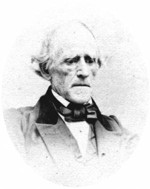
There are only two known portraits of Lane, although the figures in Sunrise on the Maine Coast, Mount Desert Island, 1856 (inv. 295) and New England Inlet with Self-Portrait, 1848 (inv. 77) have long been believed to be self-portraits.
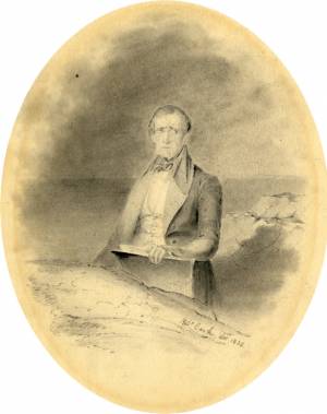
Portrait of Lane at age 31, as inscribed on reverse: "This is a portrait of F. H. Lane, Drawn with a lead-pencil from life in 1835."
Also filed under: Cooke, Robert »