An online project under the direction of the CAPE ANN MUSEUM
Catalogue Entry
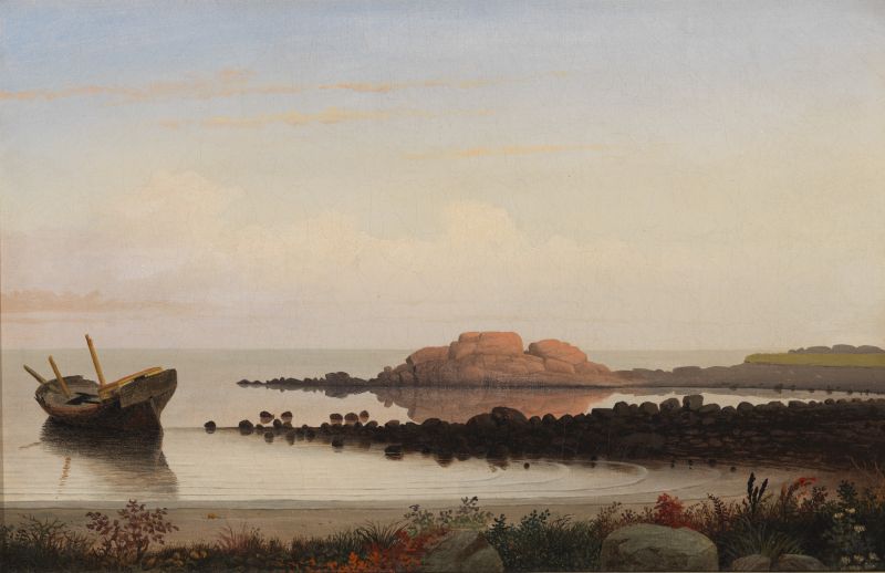
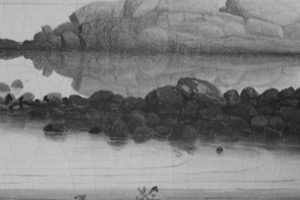
This version may have been the first painting of the series, according to recent research published by Marcia Steele and Travers Newton of the Cleveland Museum of Art. The theory is that in this painting, the height of the horizon line relative to the bluff on the right connecting to Brace’s Rock matches the field sketch. In the other two versions of this composition (see below) the horizon line has been lowered by about 1.5 centimeters (in the Private collection version) and 3 centimeters (in the National Gallery painting). Lowering the horizon line serves to accentuate the height and compositional presence of Brace’s Rock itself, leading to the theory that Lane painted the Cape Ann Museum version first, then wanted the rock to have more presence and progressively lowered the horizon line in the two subsequent versions.
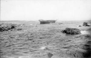
Like many other nineteenth-century painters, Lane used the device of the wrecked ship, generally accepted as a symbol of the transient nature of life. In the Brace’s Rock series this device is particularly effective in creating the sense of melancholy so palpable in these paintings, but one cannot also help but notice how beautifully these shipwrecked hulls are conceived and painted. Lane is once again finding a way to lovingly shape and paint his favorite subject, whatever its use in the overall composition.
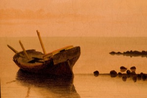
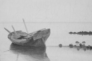
The foreground details of these three paintings are all different. This version shows Lane’s typically beautiful mix of shoreline bushes and grasses interspersed with granite boulders fronting the crescent beach. Some of the leaves have turned red and yellow, corresponding to the late summer season and also enlivening the dark greens and grays of the foreground shadow. Note the differences in the three foreground details shown below.
The composition is made up of three horizontal lines: the foreground, the black rock reef, and Brace’s Rock itself. The foreground beach arcs around to the reef mirrored by the small waves coming ashore. This arc leads the eye out along the reef and to the stranded boat with the broken masts. Note the yellow-and-red deckhouse at the vessel's stern to brighten up the gray and brown of the wreck. Brace’s Rock glows pink and orange in the late afternoon light, and note how Lane has accentuated its color by using a muted gray for the adjacent rocks. The rich grays and browns of the reef also serve as a dramatic counterpoint to the warm colors of the rock. The shape of the rock has been crowned with a cumulus cloud just above for further emphasis. It is a deceptively simple and humble painting of a modest subject. Lane's work expresses a quiet but powerful emotion.
– Sam Holdsworth

Historical Materials
Filed under: Brace's Cove / Rock » // Site Photographs »
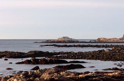
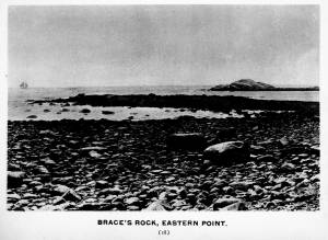
Brace’s Rock protrudes off the eastern shore of Eastern Point at the mouth of Brace’s Cove, a small and deceptively peaceful cove with a lovely crescent beach set in the otherwise rockbound coast of the eastern arm of Gloucester Harbor, about a mile north of the harbor entrance. Belying the serenity of Lane’s paintings, Brace’s Rock, the cove and the ledge forming its northern arm was one of the worst sailing hazards on the entire New England coast. This shore was the scene of countless shipwrecks and loss of life due to its appearance from the sea as a false entrance to Gloucester Harbor. Infamously known as False Point in the days of sail, lookouts on board ship peering through bad weather would see traces of Gloucester harbor and ships at anchor over the low lying land and Niles Pond that separate Brace's Cove from the harbor. They would guide the vessel around what they thought was the end of Eastern Point into the harbor. A reef of rocks jutting across the entrance to Brace Cove brought innumerable ships to grief in this manner. Nowhere on Cape Ann is the illusion of the wild ocean seemingly tamed by a sheltering bay more tragically real than Brace’s Cove seen on a still summer afternoon as Lane has painted it.
In Lane’s day Brace's Cove was still a wild and untouched area of Cape Ann, part of the privately owned Nile’s Farm, and was unvisited by tourists and unsuited for maritime interests. Lane did his drawings from the coast just north of the cove, not from the beach where most would assume he did the drawing. Brace's Rock looks identical from either vantage point.
Also filed under: Site Photographs »
Eastern Point is the long promontory that defines the eastern limit of Gloucester Harbor. In Lane's day it was wild and uninhabited but was also a strategic landmark. A Civil War fort was built there in 1863. Lane painted his seminal series of Brace's Cove and Brace's Rock from a vantage point on the eastern side.
The area was made safer for navigation by the construction of a new lighthouse in 1831 and the breakwater known as the Dog Bar. First proposed in 1866 in order to reduce turbulence in the waters of the outer harbor during heavy weather, it was not until 1894 that work on its construction began. Progress was slow, and although an extraordinary number of shipwrecks and groundings in 1898 sped it up somewhat, the breakwater was not completed until 1905.
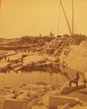
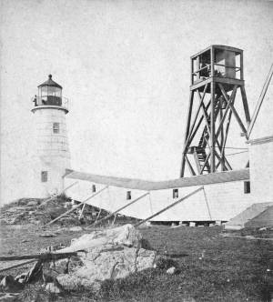
c.1880 Stereograph card Cape Ann Museum Library & Archive
This view shows a wood derrick for hoisting granite blocks.
Also filed under: Granite Quarrying / Shipping » // Historic Photographs »
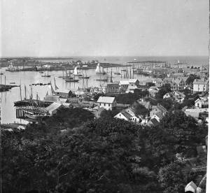
Glass plate negative from Benham Collection
Cape Ann Museum Library & Archive
View of Gloucester Harbor from Friend Street Wharves, Five Pound Island segment at far left, Rocky Neck, Eastern Point and Ten Pound Island in background.
Also filed under: Five Pound Island » // Gloucester – City Views »

Engraving of 1819 survey taken from American Coast Pilot 14th edition
9 1/2 x 8 in.
Cape Ann Museum Library & Archive
D32 FF5
Also filed under: Dolliver's Neck » // Maps » // Norman's Woe » // Ten Pound Island »

c.1870 Stereograph card Procter Brothers, Publisher Cape Ann Museum Library & Archive
View from Civil War fort on Eastern Point.
Also filed under: Gloucester Harbor, Outer » // Historic Photographs »
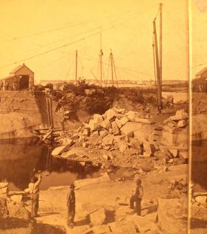
c.1880 Stereograph card Cape Ann Museum Library & Archive
This view shows a wood derrick for hoisting granite blocks.
Also filed under: Granite Quarrying / Shipping » // Historic Photographs »
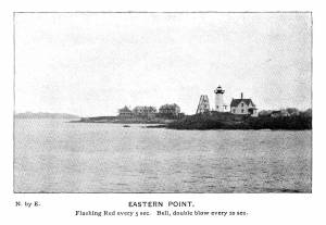
Plate from The Illustrated Coast Pilot with Sailing Directions: The Coast of New England from New York to Eastport, Maine including Bays and Harbors, published by N. L. Stebbins,1896.
Also filed under: Gloucester, Mass. – Eastern Point Light »
Stereograph card
Published by Frank Rowell
Cape Ann Museum Library & Archive
Also filed under: Gloucester, Mass. – Eastern Point Light »

John Heywood Photo for Hervey Friend
Cape Ann Museum Library & Archive (2013.068)
Schooners anchored on the Pancake Ground, taken from from Wonson's Cove, easterly side of the Rocky Neck causeway. Eastern Point Fort and garrison in background to far left.
Also filed under: Gloucester Harbor, Outer »
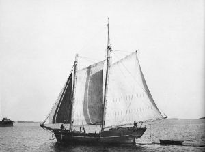
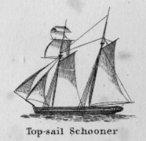
Schooners in Lane’s time were, with few exceptions, two-masted vessels carrying a fore-and-aft rig having one or two jibs, a fore staysail, gaff-rigged fore- and main sails, and often fore- and main topsails. One variant was the topsail schooner, which set a square topsail on the fore topmast. The hulls of both types were basically similar, their rigs having been chosen for sailing close to the wind. This was an advantage in the coastal trade, where entering confined ports required sailing into the wind and frequent tacking. The square topsail proved useful on longer coastwise voyages, the topsail providing a steadier motion in offshore swells, reducing wear and tear on canvas from the slatting of the fore-and-aft sails. (1)
Schooners of the types portrayed by Lane varied in size from 70 to 100 feet on deck. Their weight was never determined, and the term “tonnage” was a figure derived from a formula which assigned an approximation of hull volume for purposes of imposing duties (port taxes) on cargoes and other official levies. (2)
Crews of smaller schooners numbered three or four men. Larger schooners might carry four to six if a lengthy voyage was planned. The relative simplicity of the rig made sail handling much easier than on a square-rigged vessel. Schooner captains often owned shares in their vessels, but most schooners were majority-owned by land-based firms or by individuals who had the time and business connections to manage the tasks of acquiring and distributing the goods to be carried. (3)
Many schooners were informally “classified” by the nature of their work or the cargoes they carried, the terminology coined by their owners, agents, and crews—even sometimes by casual bystanders. In Lane’s lifetime, the following terms were commonly used for the schooner types he portrayed:
Coasting schooners: This is the most general term, applied to any merchant schooner carrying cargo from one coastal port to another along the United States coast (see Bar Island and Mt. Desert Mountains from Somes Settlement, 1850 (inv. 401), right foreground). (4)
Packet schooners: Like packet sloops, these vessels carried passengers and various higher-value goods to and from specific ports on regular schedules. They were generally better-maintained and finished than schooners carrying bulk cargoes (see The Old Fort and Ten Pound Island, Gloucester, 1850s (inv. 30), center; and Gloucester Inner Harbor, 1850 (inv. 240), stern view). (5)
Lumber schooners: Built for the most common specialized trade of Lane’s time, they were fitted with bow ports for loading lumber in their holds (see View of Southwest Harbor, Maine: Entrance to Somes Sound, 1852 (inv. 260)) and carried large deck loads as well (Stage Rocks and the Western Shore of Gloucester Outer Harbor, 1857 (inv. 8), right). Lumber schooners intended for long coastal trips were often rigged with square topsails on their fore masts (see Becalmed Off Halfway Rock, 1860 (inv. 344), left; ; and Lumber Schooner in a Gale, 1863 (inv. 552)). (6)
Schooners in other specialized trades. Some coasting schooners built for carrying varied cargoes would be used for, or converted to, special trades. This was true in the stone trade where stone schooners (like stone sloops) would be adapted for carrying stone from quarries to a coastal destination. A Lane depiction of a stone schooner is yet to be found. Marsh hay was a priority cargo for gundalows operating around salt marshes, and it is likely that some coasting schooners made a specialty of transporting this necessity for horses to urban ports which relied heavily on horses for transportation needs. Lane depicted at least two examples of hay schooners (see Gloucester Harbor, 1850s (inv. 391), left; and Coasting Schooner off Boon Island, c.1850 (inv. 564)), their decks neatly piled high with bales of hay, well secured with rope and tarpaulins.
– Erik Ronnberg
References:
1. Howard I. Chapelle, The History of American Sailing Ships (New York: W.W. Norton & Co., 1935), 258. While three-masted schooners were in use in Lane’s time, none have appeared in his surviving work; and Charles S. Morgan, “New England Coasting Schooners”, The American Neptune 23, no. 1 (DATE): 5–9, from an article which deals mostly with later and larger schooner types.
2. John Lyman, “Register Tonnage and its Measurement”, The American Neptune V, nos. 3–4 (DATE). American tonnage laws in force in Lane’s lifetime are discussed in no. 3, pp. 226–27 and no. 4, p. 322.
3. Ship Registers of the District of Gloucester, Massachusetts, 1789–1875 (Salem, MA: The Essex Institute, 1944). Vessels whose shipping or fishing voyages included visits to foreign ports were required to register with the Federal Customs agent at their home port. While the vessel’s trade or work was unrecorded, their owners and master were listed, in addition to registry dimensions and place where built. Records kept by the National Archives can be consulted for information on specific voyages and ports visited.
4. Howard I. Chapelle, The National Watercraft Collection (Washington, DC: Smithsonian Institution, 1960), 40, 42–43.
5. Ibid., 42–43, 73.
6. Ibid., 74–76.

In R. H. Dana, The Seaman's Friend, 13th ed. (Thomas Groom & Co. Publisher, 1873)
A topsail schooner has no tops at her foremast, and is fore-and-aft rigged at her mainmast. She differs from an hermaphrodite brig in that she is not properly square-rigged at her foremast, having no top, and carrying a fore-and-aft foresail instead of a square foresail and a spencer.

Detail views: marine railway and hauling cradle for vessel Wood rails, metal rollers, chain; wood cradle. Scale: ½" = 1' (1:24) Original diorama components made, 1892; replacements made, 1993. Cape Ann Museum, from Gloucester Chamber of Commerce, 1925 (2014.071)
A schooner is shown hauled out on a cradle which travels over racks of rollers on a wood and metal track.
Also filed under: Burnham Brothers Marine Railway » // Marine Railways »

c. 1900 Glass plate negative Collection of Erik Ronnberg
Also filed under: Lobstering »
"The Maine Register for the Year 1855, embracing State and County Officers, and an abstract of the law and resolves; together with a complete business directory of the state, and a variety of useful information."
Details about Maine's lumber trade in 1855, see pp. 250–52
Also filed under: Castine » // Lumber Industry »
