An online project under the direction of the CAPE ANN MUSEUM
Historical Materials: Maine Locales & Buildings
Historical Materials » Maine Locales & Buildings » Southwest Harbor
You have navigated to this pages from catalog entry: Entrance of Somes Sound, Mount Desert, Maine, 1855 (inv. 347)
Southwest Harbor
View related Fitz Henry Lane catalog entries (5) »
Southwest Harbor and Northeast Harbor flank Somes Sound of Mount Desert. The harbor is shared by two small villages, Manset, to the south, and Southwest Harbor and Clark Point to the north.The community often sent fishing vessels to the Labrador fleet. The swelling tide of artists, sightseers, philosophers, and pilgrims in the 1830s, '40s, and '50s would inspire such entrepreneurs as Deacon Henry H. Clark of Southwest Harbor, a shipwright, to build hotels to accommodate the travelers. This was a growth industry would sustain the prosperity of the island communities and their small farms in the years after the Civil War.
Southwest Harbor, which included Tremont until 1848, sent six schooners averaging 58 tons with the Labrador fleet in 1839. The smallest of these vessels was the 35 ton "Four Sisters" which could not have exceeded 50 feet. The Labrador fishery was ideal for such a small craft, for it allowed vessels to anchor in safe harbors, unbending their sails, and setting their men adrift in small boats near the shore. This practice would continue into the 1860s. These small vessels were ideal for men with limited capital who could easily afford to build and maintain these small vessels. More often than not, the crew would consist of a father and his sons, or all of the able-bodied men living in a small island community.
The British raided what is now Southwest Harbor in 1775 and attacked the home of John Manchester. The British killed or stole the livestock, took all of the winter provisions, and returned to the westward on board the "Falmouth Packet," but not before they told Mrs. Manchester that she could starve for all they cared. John Bunker, Manchester's brother-in-law, paddled his canoe westward in pursuit of the marauding British. He found them on the Sheepscot River at Wiscasset, and the "Falmouth Packet" at anchor with her crew on shore. He cut the lines in the dark of night, let the schooner drift with the tide, and then made sail, heading back to Mount Desert. The supplies were badly needed, as Downeast Maine was caught in the grip of a British embargo and families were starving. The supplies would carry the settlers through the winter. The British would come calling again on August 8, 1814, aboard the sloop of war "Tenados," and lost seven soldiers in a skirmish off Clark's Point. Capt. Benjamin Spurling of Cranberry Isle, whose grandson would be awarded the Medal of Honor after the Civil War, was in the thick of fighting with a ragtag band of fishermen who could only loosely be called a militia. Capt. Spurling would command a privateer during the war.
– Mark Honey
References:
Duncan, Roger F, "Coastal Maine, A Maritime History," WW Norton & Company, New York, 1992
O'Leary, Wayne M, "Maine Sea Fisheries," The Rise and Fall of a Native Industry, 1830-1890, Northeastern University Press, Boston, 1996.
Related tables: Mount Desert Island & Rock » // Northeast Harbor » // Somes Sound »
Chart
U.S. Coast Survey
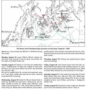
Chart with key showing the route of an excursion on the sloop "Superior" out of Castine made by William H. Witherle, Lane, Stevens and friends during which Lane made several sketches of Mt. Desert scenery. The trip was chronicled by Witherle in his diary of 1852.
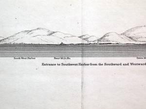
Illustration
"U.S. Coast Pilot, Atlantic Coast, Parts I–II." First edition. Published by Washington GPO, 1891
Folded plate between pp. 62 and 63
Also filed under: Bear Island » // Maps » // Mount Desert Island & Rock » // Northeast Harbor, Maine – Bear Island Lighthouse »

