An online project under the direction of the CAPE ANN MUSEUM
Catalogue Entry
Historical Materials
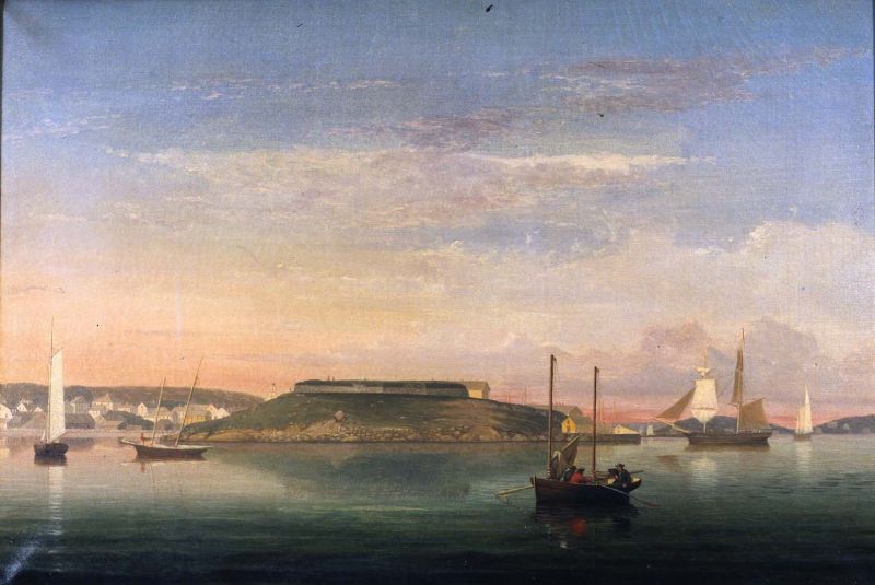
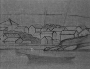
George H. Rogers was one of Gloucester's most enterprising citizens of the mid-nineteenth century. In the early 1830s, he ventured into the Surinam trade with great success, leading him to acquire a wharf at the foot of Sea Street. Due to Harbor Cove's shallow bottom at low tide, berthings at wharves had to be done at high tide, leaving the ships grounded at other times. Many deep-loaded vessels had to anchor outside Harbor cove and be partially off-loaded by "lighters" (shallow-draft vessels that could transfer cargo to the wharves) before final unloading at wharfside. To lessen this problem, Rogers had an unattached extension built out from his wharf into deeper water (see The Fort and Ten Pound Island, Gloucester (Harbor Scene), 1848 (inv. 58), right middle ground). The space between the old wharf and the extension may have been a way to evade harbor regulations limiting how far a pier head could extend into the harbor. Stricter rules were not long in coming after this happened!
About 1848, Rogers acquired land on the east end of Fort Point, first putting up a large three-story building adjacent to Fort Defiance, then a very large wharf jutting out into Harbor Cove. Lane's depictions of Harbor Cove and Fort Point show progress of this construction in 1848 (The Fort and Ten Pound Island, Gloucester (Harbor Scene), 1848 (inv. 58)), 1850 (Gloucester Inner Harbor, 1850 (inv. 240)), and c.1851 (Gloucester Harbor at Dusk, c.1852 (inv. 563)). A corner of the new wharf under construction can also be seen more closely in Ten Pound Island, Gloucester, 1850s (inv. 17) and Ten Pound Island in Gloucester Harbor, 1864 (inv. 104) (foregrounds). This new wharf provided better frontage for large ships to load and unload, as well as larger warehouses and lofts for storage of goods and vessel gear.
By 1860, Rogers was unloading his Surinam cargos at Boston, as ever-larger ships and barks were more easily berthed there. His Gloucester wharves continued to be used for deliveries of trade goods by smaller vessels. In the late 1860s, Rogers' wharf at Fort Point (called "Fort Wharf" in Gloucester directories) was acquired by (Charles D.) Pettingill & (Nehemiah) Cunningham for use in "the fisheries" as listed by the directory. in 1876, it was sold to (John J.) Stanwood & Company, also for use in "the fisheries." (1)
Lowe's Wharf, adjacent to Fort Wharf, was acquired by (Sylvester) Cunningham & (William) Thompson, c.1877 and used in "the fisheries" as well. That wharf and its buildings were enlarged considerably as the business grew. By this time, Harbor Cove was completely occupied by businesses in the fisheries or providing services and equipment to the fishing fleet. In photographs of Fort Point from this period, it is difficult to distinguish one business from another, so closely are they adjoined.
– Erik Ronnberg
Reference:
1. A city atlas, dated 1899, indicates that Rogers's wharf at Fort Point was still listed as part of his estate. If so, then Stanwood & Co. would have been leasing that facility from the Rogers's estate.
44 x 34 in.
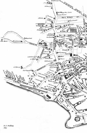
Henry Francis Walling, Map of the Towns of Gloucester and Rockport, Essex Co. Massachusetts. Philadelphia, A. Kollner, 1851
Cape Ann Museum Library & Archive
"Map of the Towns of Gloucester and Rockport, Massachusetts. H.F. Walling, Civil Engineer. John Hanson, Publisher. 1851. Population of Gloucester in 1850 7,805. Population of Rockport in 1850 3,213."
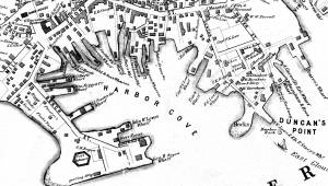
Segment of Harbor Village portion of map showing Low's, Rogers', and other wharves in the Inner Harbor.
Also filed under: Low (Frederick G.) wharves »
44 x 34 in.
Henry Francis Walling, Map of the Towns of Gloucester and Rockport, Essex Co. Massachusetts. Philadelphia, A. Kollner, 1851
Cape Ann Museum Library & Archive
"Map of the Towns of Gloucester and Rockport, Massachusetts. H.F. Walling, Civil Engineer. John Hanson, Publisher. 1851. Population of Gloucester in 1850 7,805. Population of Rockport in 1850 3,213."

44 x 34 in.
John Hanson, Publisher
Cape Ann Museum Library & Archive
"Map of the Towns of Gloucester and Rockport, Massachusetts. H.F. Walling, Civil Engineer. John Hanson, Publisher. 1851. Population of Gloucester in 1850 7,805. Population of Rockport in 1850 3,213."
Also filed under: Fort (The) and Fort Point » // Low (Frederick G.) wharves » // Maps » // Town / Public Landings » // Waterfront, Gloucester » // Windmill »

1865 41 x 29 inches Courtesy of the Massachusetts Archives Maps and Plans, Third Series Maps, v.66:p.1, no. 2352, SC1/series 50X
.
Also filed under: Burnham Brothers Marine Railway » // Collins's, William (estate wharf) » // Gloucester Harbor, Inner / Harbor Cove » // Maps »

1876 Photograph Cape Ann Museum Library & Archive
Ignatius Weber's windmill (now defunct) is shown.
Also filed under: Flake Yard » // Fort (The) and Fort Point » // Gloucester Harbor, Inner / Harbor Cove » // Historic Photographs » // Schooner (Fishing) » // Waterfront, Gloucester » // Windmill »
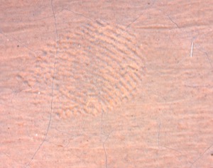
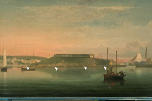
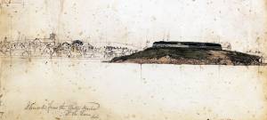
Through the years, this point and its fortifications had many names: Watch House Point, the Old Battery, Fort Defiance, Fort Head, and now just "The Fort." In 1793, Fort Defiance was turned over to the young United States government and was allowed to deteriorate. During the War of 1812 it was described as being "in ruins," and any remaining buildings burned in 1833. It was resuscitated in the Civil War and two batteries of guns were installed. The City of Gloucester did not regain ownership of the land until 1925.
The first fortifications on this point, guarding the entrance to the Inner Harbor, were put up in the 1740s, when fear of attack from the French led to the construction of a battery armed with twelve-pounder guns. Greater breastworks were thrown up in 1775, after Capt. Lindsay and his sloop-of-war the "Falcon" attacked the unprepared town. They were small and housed only a few cannon and local soldiers. Several other fortifications were at various times erected around the harbor: Fort Conant at what is now Stage Fort Park, another on Duncan's Point (near site of Lane's house) and the Civil War fort on Eastern Point. None of these preparations was ever called upon to actually defend the town.
Lane during his lifetime created a long series of images of the point and the condition of its fortifications. In 1832 there were still buildings standing, and the point had not yet been used for major wharves and warehouses. By the time of his painting Gloucester Harbor, 1852 (inv. 38), one can see that the earthwork foundation, but no superstructures, survived.
– Sarah Dunlap


1860 In John J. Babson, History of the Town Gloucester (Gloucester, MA: Procter Brothers, 1860) Cape Ann Museum Library & Archives, Gloucester, Mass.
See p. 474.
View related catalogue entries (4) »
Also filed under: Babson History of the Town of Gloucester » // Chebacco Boat / Dogbody / Pinky » // Gloucester Harbor, Inner / Harbor Cove » // Gloucester, Mass. - "Ten Pound Island Light » // Schooner (Coasting / Lumber / Topsail / Packet / Marsh Hay) » // Ten Pound Island »
Newsprint
Gloucester Telegraph
About picture of Old Fort hanging in the Gloucester Bank: "This picture is chiefly of interest on account of its preserving so accurately the features of a view so familiar to many of our citizens and which can never exist in reality."
Also filed under: Chronology » // Gloucester Bank » // Gloucester, Mass. – Gloucester Bank » // Newspaper / Journal Articles »

24 x 38 in.
Gloucester City Archives
"Drawn on a scale of one hundred feet to an inch. By John Mason 1834–45 from Actual Survey showing every Lott and building then standing on them giving the actual size of the buildings and width of the streets from the Canal to the head of the Harbour & part of Eastern point as farr as Smith's Cove and the Shore of the same with all the wharfs then in use. Gloucester Harbor 1834–35."
This map is especially useful in showing the Fort.
Also filed under: Flake Yard » // Maps » // Mason, John » // Pavilion (Publick) Beach » // Town / Public Landings »
44 x 34 in.
John Hanson, Publisher
Cape Ann Museum Library & Archive
"Map of the Towns of Gloucester and Rockport, Massachusetts. H.F. Walling, Civil Engineer. John Hanson, Publisher. 1851. Population of Gloucester in 1850 7,805. Population of Rockport in 1850 3,213."
Also filed under: Low (Frederick G.) wharves » // Maps » // Rogers's (George H.) wharves » // Town / Public Landings » // Waterfront, Gloucester » // Windmill »
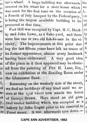
Newsprint
Cape Ann Advertiser
Cape Ann Museum Library & Archive
"Fort Hill was occupied by Capt. H. C. Mackay and John Lowe, as a flake-yard, and there were but one or two old fish-houses in the vicinity. The improvements at this point during the last fifteen years have left no traces of its former appearance, almost every landmark having been obliterated. A very good idea of the place as it then appeared may be obtained from the painting of Fitz H. Lane, Esq., now on exhibition at the Reading Room under the Gloucester Bank."
Also filed under: Gloucester Bank » // Newspaper / Journal Articles »
Newspaper
Gloucester Telegraph
"By the will of the late Fitz H. Lane, Esq., his handsome painting of the Old Fort, Ten Pound Island, etc., now on exhibition at the rooms of the Gloucester Maritime Insurance Co., was given to the town... It will occupy its present position until the town has a suitable place to receive it."
Also filed under: Funeral & Burial » // Gloucester, Mass. – Marine Insurance Company » // Newspaper / Journal Articles » // Ten Pound Island »
Newsprint
Gloucester Telegraph
At the dedication of the Town House, speaker, "read the following letter:
To the Selectmen of Gloucester: / Gents: The will of our late Townsman, Fitz. H. Lane, contains this provision: / I give to the inhabitants of the Town of Gloucester, the picture of the Old Fort, to be kept as a memento[sic] of one of the localities of olden time; the said picture now hanging in the Reading Room under the Gloucester Bank, and to be there kept until the Town of Gloucester shall furnish a suitable and safe place to hang it. / The original sketch was taken twenty-five years ago, but the boats and vessels introduced are those of a quarter of a century earlier still. The painting was executed in 1859, six years before his decease."
Also filed under: Documents / Objects » // Newspaper / Journal Articles » // Town House »

Stereograph card
Cape Ann Museum Library & Archive
View from top of Unitarian Church on Middle Street looking southeast, showing the Fort and Ten Pound Island. Tappan Block and Main Street buildings between Center and Hancock in foreground.
Also filed under: Ten Pound Island » // Unitarian Church / First Parish Church (Middle Street) »
1876 Photograph Cape Ann Museum Library & Archive
Ignatius Weber's windmill (now defunct) is shown.
Also filed under: Flake Yard » // Gloucester Harbor, Inner / Harbor Cove » // Historic Photographs » // Rogers's (George H.) wharves » // Schooner (Fishing) » // Waterfront, Gloucester » // Windmill »
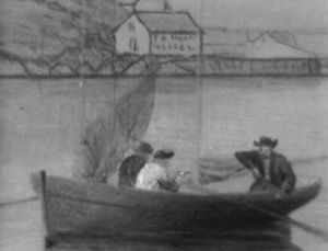
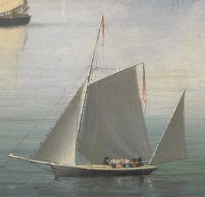
"Party boat" is a colloquial term for any kind of small craft adapted or used for taking guests (customarily for hire) on sightseeing trips or fishing for pleasure. (1) The term survives to this day on Cape Ann and other places for vessels engaged in the same activities. (2) In Lane's time, party boating was a calling of opportunity, and a fisherman's boat might be used in season - regularly or occasionally - to take "rusticators" fishing. Likewise, a boat used for its owner's own pleasure might be hired to take sightseers sailing for an afternoon. The latter use is seen in Lane's 1844 view of Gloucester Harbor from Rocky Neck (see the yawl-rigged sailboat in the foreground of Gloucester Harbor from Rocky Neck, 1844 (inv. 14)).
By the early 1850s, summer visitor activity, encouraged by the building of the Pavilion Hotel on Gloucester's waterfront, led to increased pleasure boating activity, if Lane's painting Gloucester Harbor, 1852 (inv. 38) of Pavilion Beach and Sidney Mason's hotel is any indication. (3) Lane's Gloucester Harbor scenes from this decade show a number of pleasure craft suitable for taking passengers for hire (see Fresh Water Cove from Dolliver's Neck, Gloucester, Early 1850s (inv. 45), Coming Ashore near Brace's Rock, Gloucester, Massachusetts, c.1860 (inv. 60), and View of Gloucester from "Brookbank," the Sawyer Homestead, c.1856 (inv. 95)). Small working craft suitable for this purpose are seen in The Old Fort and Ten Pound Island, Gloucester, 1850s (inv. 30), Gloucester Harbor, 1852 (inv. 38) (right foreground), View of Gloucester, 1859 (inv. 91) (foreground), and Watch House Point, 1860 (inv. 292) (right foreground). In View of Gloucester Harbor, 1848 (inv. 97), we see passengers boarding a small sloop-rigged boat hidden by the rocks at Duncan's Point (left middle ground).
In coastal waters south of Gloucester, a few of Lane's paintings offer pleasure craft as candidates for taking paying passengers. Phantom of Boston, c.1850s (inv. 574) depicts a cruising yawl "Phantom" of Boston, beached with hunting gear unloaded alongside while two of the crew await an approaching party in a rowing boat. The location is unidentified, but a possibility is the barrier beach around the marshes of Lynn, Massachusetts, which were once very popular hunting grounds for migrating waterfowl. A second candidate is a small sloop with a party of four on an evening sail off Halfway Rock in Becalmed Off Halfway Rock, 1860 (inv. 344) (far right).
Lane found similar uses of working watercraft in Maine, where the families of a small coastal community would travel by their workboats to a gathering place for a clambake or similar festive outing (see View of Indian Bar Cove, Brooksville, Maine, 1850 (inv. 61)). The artist became a "rusticator" himself when he, Joseph Stevens, and friends explored Mount Desert Island and vicinity in the "General Gates," a sloop-rigged Maine version of a New England Boat (View of Bar Island and Mount Desert Mountains, from the Bay in Front of Somes Settlement, 1850 (inv. 177) and Castine Harbor and Town, 1851 (inv. 272)).
When Lane traveled to New Bedford in 1856 to observe and sketch a regatta held by the New York Yacht Club, he observed and sketched it while on board an unknown vessel near the starting and finishing line, formed by the race committee boat "Emblem" and her yawl-boat.
Close by was a small party boat with observers on board, probably a fishing sloop, given its work-a-day looks. In the ensuing year, Lane painted four detailed views of this race, the party boat appearing in New York Yacht Club Regatta (1), 1856 (inv. 66) (right foreground); New York Yacht Club Regatta (2), 1856 (inv. 270) (right margin); New York Yacht Club Regatta (3), After 1856 (inv. 396) (center); and New York Yacht Club Regatta (4), 1857 (inv. 397) (left foreground). (4)
– Erik Ronnberg
References:
1. M. H. Parry and others, Aak to Zumbra: A Dictionary of the World's Watercraft (Newport News, VA: The Mariners' Museum, 2000), 436.
2. Ibid.
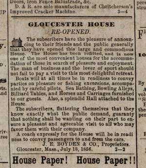
3. Proctor's Able Sheet (a Gloucester newspaper), January 1857: "Gloucester House reopened—refitted—boats always ready to take parties cruising or fishing..."
4. John Wilmerding, Fitz Henry Lane, 2nd ed. (Cape Ann, MA: Cape Ann Historical Association, 2005), 52–54. Lane's 1852 cruise in the Mount Desert region in the sloop "Superior" was reprinted as an appendix to Wilmerding's essay in Paintings by Fitz Hugh Lane (Washington, DC: National Gallery of Art, 1988), 125–26.
Oil on canvas
34 x 45 3/4 in.
Cape Ann Museum, Gloucester, Mass., Gift of Mrs. Jane Parker Stacy (Mrs. George O. Stacy),1948 (1289.1a)
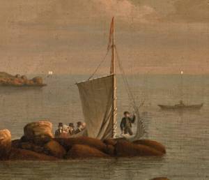
Detail of party boat.
Also filed under: Gloucester Harbor, Inner / Harbor Cove »

Oil on canvas
22 x 36 in.
Cape Ann Museum, Gloucester, Mass., deposited by the Collection of Addison Gilbert Hospital, 1978 (DEP. 201)
Detail of party boat.
Also filed under: Ten Pound Island »
Newspaper
Ad in Gloucester Telegraph
FISHING AND SAILING PARTIES
"Persons desirous of enjoying a SAILING or FISHING EXCURSION, are informed that the subscriber will be in readiness with the Boat EUREKA, to attend to all who may favor him with their patronage. JOHN J. FERSON"
Also filed under: Gloucester Harbor – Use » // Newspaper / Journal Articles »
Newsprint
Ad for Gloucester House
Courtesy of the American Antiquarian Society, Worcester, Mass.
See p. 4, column 2.
Also filed under: Brick Houses / Gloucester House Hotel » // Newspaper / Journal Articles »
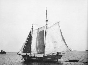
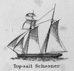
Schooners in Lane’s time were, with few exceptions, two-masted vessels carrying a fore-and-aft rig having one or two jibs, a fore staysail, gaff-rigged fore- and main sails, and often fore- and main topsails. One variant was the topsail schooner, which set a square topsail on the fore topmast. The hulls of both types were basically similar, their rigs having been chosen for sailing close to the wind. This was an advantage in the coastal trade, where entering confined ports required sailing into the wind and frequent tacking. The square topsail proved useful on longer coastwise voyages, the topsail providing a steadier motion in offshore swells, reducing wear and tear on canvas from the slatting of the fore-and-aft sails. (1)
Schooners of the types portrayed by Lane varied in size from 70 to 100 feet on deck. Their weight was never determined, and the term “tonnage” was a figure derived from a formula which assigned an approximation of hull volume for purposes of imposing duties (port taxes) on cargoes and other official levies. (2)
Crews of smaller schooners numbered three or four men. Larger schooners might carry four to six if a lengthy voyage was planned. The relative simplicity of the rig made sail handling much easier than on a square-rigged vessel. Schooner captains often owned shares in their vessels, but most schooners were majority-owned by land-based firms or by individuals who had the time and business connections to manage the tasks of acquiring and distributing the goods to be carried. (3)
Many schooners were informally “classified” by the nature of their work or the cargoes they carried, the terminology coined by their owners, agents, and crews—even sometimes by casual bystanders. In Lane’s lifetime, the following terms were commonly used for the schooner types he portrayed:
Coasting schooners: This is the most general term, applied to any merchant schooner carrying cargo from one coastal port to another along the United States coast (see Bar Island and Mt. Desert Mountains from Somes Settlement, 1850 (inv. 401), right foreground). (4)
Packet schooners: Like packet sloops, these vessels carried passengers and various higher-value goods to and from specific ports on regular schedules. They were generally better-maintained and finished than schooners carrying bulk cargoes (see The Old Fort and Ten Pound Island, Gloucester, 1850s (inv. 30), center; and Gloucester Inner Harbor, 1850 (inv. 240), stern view). (5)
Lumber schooners: Built for the most common specialized trade of Lane’s time, they were fitted with bow ports for loading lumber in their holds (see View of Southwest Harbor, Maine: Entrance to Somes Sound, 1852 (inv. 260)) and carried large deck loads as well (Stage Rocks and the Western Shore of Gloucester Outer Harbor, 1857 (inv. 8), right). Lumber schooners intended for long coastal trips were often rigged with square topsails on their fore masts (see Becalmed Off Halfway Rock, 1860 (inv. 344), left; ; and Lumber Schooner in a Gale, 1863 (inv. 552)). (6)
Schooners in other specialized trades. Some coasting schooners built for carrying varied cargoes would be used for, or converted to, special trades. This was true in the stone trade where stone schooners (like stone sloops) would be adapted for carrying stone from quarries to a coastal destination. A Lane depiction of a stone schooner is yet to be found. Marsh hay was a priority cargo for gundalows operating around salt marshes, and it is likely that some coasting schooners made a specialty of transporting this necessity for horses to urban ports which relied heavily on horses for transportation needs. Lane depicted at least two examples of hay schooners (see Gloucester Harbor, 1850s (inv. 391), left; and Coasting Schooner off Boon Island, c.1850 (inv. 564)), their decks neatly piled high with bales of hay, well secured with rope and tarpaulins.
– Erik Ronnberg
References:
1. Howard I. Chapelle, The History of American Sailing Ships (New York: W.W. Norton & Co., 1935), 258. While three-masted schooners were in use in Lane’s time, none have appeared in his surviving work; and Charles S. Morgan, “New England Coasting Schooners”, The American Neptune 23, no. 1 (DATE): 5–9, from an article which deals mostly with later and larger schooner types.
2. John Lyman, “Register Tonnage and its Measurement”, The American Neptune V, nos. 3–4 (DATE). American tonnage laws in force in Lane’s lifetime are discussed in no. 3, pp. 226–27 and no. 4, p. 322.
3. Ship Registers of the District of Gloucester, Massachusetts, 1789–1875 (Salem, MA: The Essex Institute, 1944). Vessels whose shipping or fishing voyages included visits to foreign ports were required to register with the Federal Customs agent at their home port. While the vessel’s trade or work was unrecorded, their owners and master were listed, in addition to registry dimensions and place where built. Records kept by the National Archives can be consulted for information on specific voyages and ports visited.
4. Howard I. Chapelle, The National Watercraft Collection (Washington, DC: Smithsonian Institution, 1960), 40, 42–43.
5. Ibid., 42–43, 73.
6. Ibid., 74–76.

In R. H. Dana, The Seaman's Friend, 13th ed. (Thomas Groom & Co. Publisher, 1873)
A topsail schooner has no tops at her foremast, and is fore-and-aft rigged at her mainmast. She differs from an hermaphrodite brig in that she is not properly square-rigged at her foremast, having no top, and carrying a fore-and-aft foresail instead of a square foresail and a spencer.

Detail views: marine railway and hauling cradle for vessel Wood rails, metal rollers, chain; wood cradle. Scale: ½" = 1' (1:24) Original diorama components made, 1892; replacements made, 1993. Cape Ann Museum, from Gloucester Chamber of Commerce, 1925 (2014.071)
A schooner is shown hauled out on a cradle which travels over racks of rollers on a wood and metal track.
Also filed under: Burnham Brothers Marine Railway » // Marine Railways »

c. 1900 Glass plate negative Collection of Erik Ronnberg
Also filed under: Lobstering »
"The Maine Register for the Year 1855, embracing State and County Officers, and an abstract of the law and resolves; together with a complete business directory of the state, and a variety of useful information."
Details about Maine's lumber trade in 1855, see pp. 250–52
Also filed under: Castine » // Lumber Industry »