An online project under the direction of the CAPE ANN MUSEUM
Historical Materials: Gloucester Buildings & Businesses
Historical Materials » Gloucester Buildings & Businesses » Collins's, William (estate wharf)
You have navigated to this pages from catalog entry: The Fort and Ten Pound Island, Gloucester (Harbor Scene), 1848 (inv. 58)
Collins's, William (estate wharf)
View related Fitz Henry Lane catalog entries (3) »
William Collins likely inherited his father's blockmaking business in 1810, including a shop and the wharf at the head of Harbor Cove. Blockmaking, which included the making of various types of rigging fittings (blocks, deadeyes, belaying pins, cleats, etc.) called for skilled workmanship and use of special types of wood. Inventories and auction announcements for William Collins’ estate give long lists of tools, materials, and products from his business. (Ref. 1)
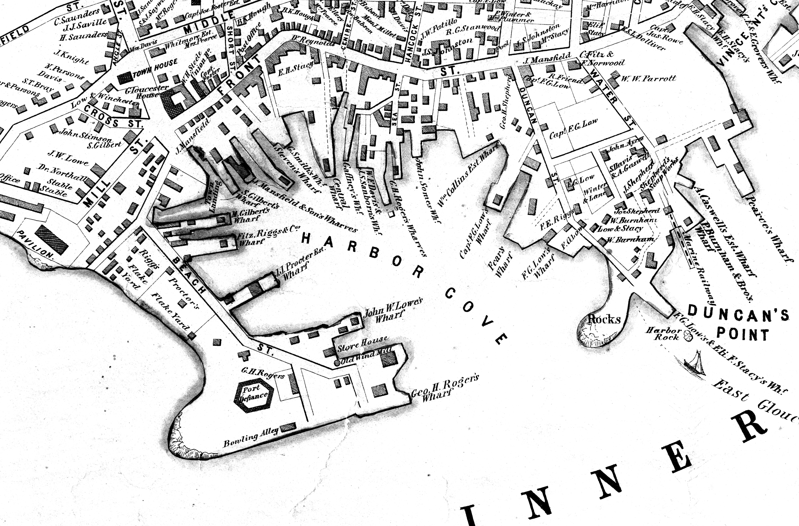
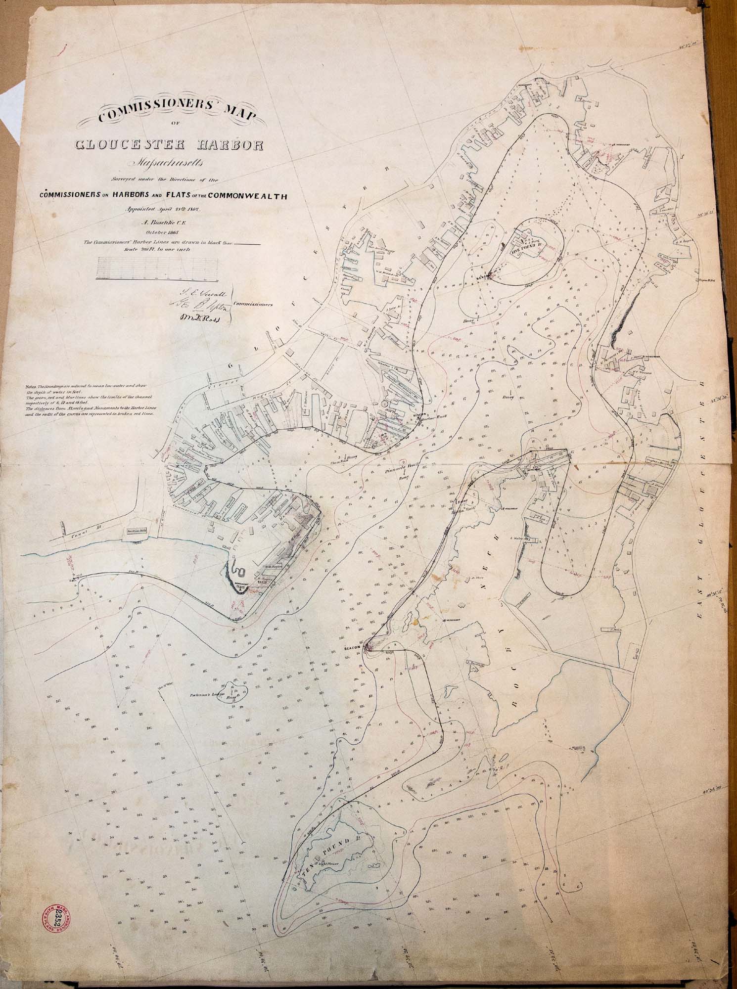
Maps of the harbor from 1835 identify the wharf as Collins property, one of them being labeled “Wm. Collins”, suggesting sole ownership by then. When William Collins died in 1845, the property remained in the hands of his family, as indicated in Walling’s map of Cape Ann (1851) and in the Commissioner’s Map of Gloucester Harbor (1865).
Collins’ death did not mean the end of his wharf’s use in his line of work. An announcement in "The Gloucester Telegraph" that year stated that Parker Burnham & Brothers would resume the blockmaking business on the wharf, along with sparmaking and carpentry. All those activities were associated not just with shipbuilding, but with vessel maintenance and repair. They possibly marked the beginning of a major change in the Burnhams’ business, which had focused on shipbuilding to this point, but was now shifting to vessel repairs, and would lead to their building Gloucester’s first marine railway half a decade later.(Ref. 3)
–Erik Ronnberg
References:
1. “Gloucester Telegraph”, April 2, 1845. Administrator’s Sale, April 9, 10 o’clock, Wm. P. Dolliver, Adm’r. Massachusetts Archives, Probate Records, Essex County, March 1845.
2. Henry F. Walling, “Map of the Towns of Gloucester and Rockport, Essex County, Massachusetts” (Philadelphia: A. Kollner, 1851). “Commissioners” Map of Gloucester Harbor, Massachusetts” (Commissioners on Harbors and Flats of the Commonwealth, October, 1865).
3. “Gloucester Telegraph”, May 7, 1845. “Removal”, Parker Burnham & Brothers, Gloucester, April 23, 1845.
Related tables: Burnham Brothers Marine Railway » // Collins, William » // Vessel Details: Parts / Fittings »
Newspaper announcement
Gloucester Telegraph
Cape Ann Museum Library & Archive
AUCTION
ADMINISTRATOR’S SALE
ON WEDNESDAY, April 9th, 10 o’clock Workshop of Wm. Collins (deceased) near Willam Burnham’s, will be sold. ALL the STOCK, TOOLS. &c. &c., of said shop,
Consisting in part as follows, About 400 Blocks of different sizes; 600 unfinish-ed Blocks; lot of Lignumvita Belaying Pins; Jib Hanks; Hand Pumps; 2 Guns; Handspikes; Knives; 1 large Grindstone; Saws; Gouges; Chisels; Planes; Augers; Bitt Stocks and Bitts; 1 Turning Lathe; 2 Vices; Stove and Funnel; Crow Bars; Hammer and Drills; Wheelbarrow; 2 large New Purchase Blocks; 2 second hand do. do.; together with a variety of other articles too numerousto mention.
Also, a SAIL BOAT
Wm. P. DOLLIVER, Adm’r.
If it should be foul weather, the sale will take
Place the first fair day after. March 29
Also filed under: Collins, William » // Newspaper / Journal Articles »
Newspaper announcement
Gloucester Telegraph
Cape Ann Museum Library & Archive
REMOVAL.
The Subscribers have taken the Wharf of the Late Mr. Wm. Collins, where they will keep a large assortment of good BLOCKS, MAST HOOPS, JIB HANKS, Hand and Vessel PUMPS, and all articles made in a Block Maker’s Shop. Blocks repaired and Well Pumps made at short notice. They will also carry on Spar making with their Carpentering business.
PARKER BURNHAM & BROTHERS.
Gloucester, April 23, 1845
Also filed under: Newspaper / Journal Articles »
44 x 34 in.
Henry Francis Walling, Map of the Towns of Gloucester and Rockport, Essex Co. Massachusetts. Philadelphia, A. Kollner, 1851
Cape Ann Museum Library & Archive
"Map of the Towns of Gloucester and Rockport, Massachusetts. H.F. Walling, Civil Engineer. John Hanson, Publisher. 1851. Population of Gloucester in 1850 7,805. Population of Rockport in 1850 3,213."
Segment of Harbor Village portion of map showing Collins' and other wharves in the Inner Harbor.
41 x 29 inches
Courtesy of the Massachusetts Archives
Maps and Plans, Third Series Maps, v.66:p.1, no. 2352, SC1/series 50X
.
Also filed under: Burnham Brothers Marine Railway » // Gloucester Harbor, Inner / Harbor Cove » // Maps » // Rogers's (George H.) wharves »