An online project under the direction of the CAPE ANN MUSEUM
Catalogue Entry
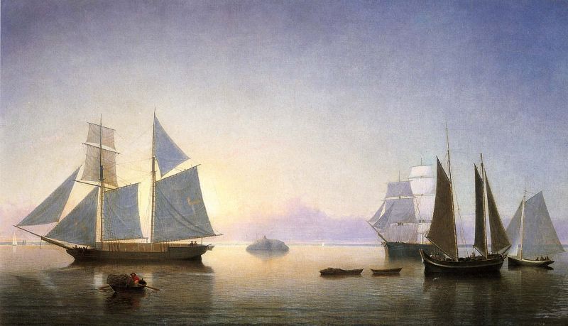
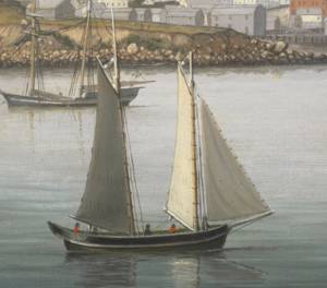
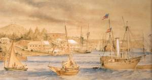
The North Shore of Massachusetts Bay from Nahant to Cape Ann forms an archipelago dotted with small islands, exposed rocks, and many more submerged rock formations that pose hazards to navigation in a heavily trafficked sea-lane. One of the outermost obstacles is a single, dome-shaped rock situated halfway between Boston and Cape Ann, one and one-half miles distant from the nearest submerged rocks. Appropriately named Halfway Rock, it was an important aid to local navigation. It was also a marker for finding many small fishing grounds to the east, and to recently discovered Stellwagen’s Bank to the southeast. (1)
We are looking due west, and it is late afternoon, the sun silhouetting the sails of the lumber schooner at left. Atop Halfway Rock is a stone monument—probably erected by the U.S. Coast Survey for triangulation in the early stages of mapping the New England coastline, ca. 1840. It was kept as an aid to navigation (as were most other monuments erected for this purpose) and fitted with a red beacon late in the nineteenth century. (2) For vessels in the coastal trade, Halfway Rock was an important marker for taking bearings to enter Marblehead, Salem, and Beverly Harbors while safely avoiding the numerous hazards.
The lumber schooner (at left) is headed south, probably to Boston, to discharge its cargo of boards, which were most likely cut and loaded in Maine (as seen in Twilight on the Kennebec, 1849 (inv. 258) and View of Southwest Harbor, Maine: Entrance to Somes Sound, 1852 (inv. 260)). For “coasters” sailing through this heavily trafficked area, passing Halfway Rock on the seaward (west) side was best for making good time and avoiding a dangerous coastline. (3)
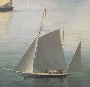
Fishermen seeking seasonal small grounds in the area, particularly eastward, relied on the rock for accurate directions. Each fishing spot was usually a patch of gravel, a rock, or a small ledge that attracted cod, haddock, and lobsters at specific times of the year, requiring specific knowledge of place, season, and target species. Symbolic of this activity are the lobsterman in his dory (left foreground) and the pinky with a dory and wherry in tow (right foreground) fitted out for gillnetting of herring (the gill net is stowed in the wherry, ready to be set). Herring schooled in this area in September—an important clue to the time of year this painting depicts. (4)
For Salem, like Gloucester, the foreign trade was on the wane, due to the increasing sizes of merchant vessels and a harbor too shallow to accommodate them. Like Gloucester merchants, Salem merchants moved their ships and offices to Boston, leaving their city open to other business ventures. The lone square-rigged merchant ship in the right background, obscured by the pinky, is symbolic of this decline, which becomes all the more obvious by comparison with Lane’s portrayal of vessel activity in his paintings of Boston Harbor. (5)
Symbolic of things to come is the small sloop at far right—one of a growing multitude of pleasure craft that will come to dominate this part of New England’s coastline after the Civil War. Yachting for the wealthy was finding its way from Boston to Marblehead, with small pleasure craft for the middle class becoming more common in working ports like Gloucester. (6)
– Erik Ronnberg
References:
1. G. Brown Goode, The Fisheries and Fishery Industries of the United States, Section III: The Fishing Grounds of North America (Washington, DC: Government Printing Office, 1887), 39–41 and Chart No. 10, “Fishing Grounds from Cape Ann to Buzzard’s Bay, Mass.”
2. United States Coast Pilot – Atlantic Coast: Part III, from Cape Ann to Point Judith (Washington, DC: Government Printing Office, 1893), 31.
3. Ibid., 22.
4. Goode, Ibid., 39, 40, and Chart No. 10.
5.Claude M. Fuess and Scott H. Paradise, The Story of Essex County (New York: The American Historical Society, Inc., 1935), Vol. 1, 376–378, 435, 436.
6. Ibid., Vol. 2, 1038, 1039.
- Subject Types
: - Seasons / Weather
: - Vessel Types
: - Activities of People
: - Objects
:
Historical Materials
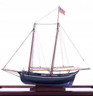
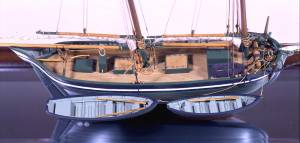
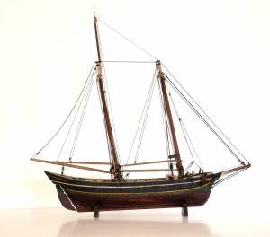
The colonial American shallop is the ancestor of many regional types of New England fishing craft found in Lane's paintings and drawings, including "New England Boats" (known as "boats" and discussed elsewhere), and later descendents, such as "Chebacco Boats," "Dogbodies," and "Pinkies."
These boats were very common work boat types on Cape Ann throughout the 1800s. They were primarily used for inshore coastal fishing, which included lobstering, gill-netting, fish-trapping, hand-lining, and the like. They were usually sailed by one or two men, sometimes with a boy, and could be rowed as well as sailed. An ordinary catch would include rock cod, flounder, fluke, dabs, or other small flat fish. The catch would be eaten fresh, or salted and stored for later consumption, or used as bait fish. Gill-netting would catch herring and alewives when spawning. Wooden lobster traps were marked with buoys much as they are today, and hauled over the low sides of the boat, emptied of lobsters and any by-catch, re-baited and thrown back.
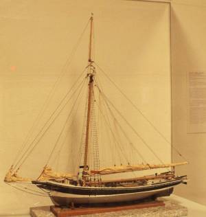
CHEBACCO BOATS AND PINKIES
In the Chebacco Parish of the Ipswich Colony, a larger version of the colonial shallop evolved to a heavily built two-masted boat with either a sharp or square stern. This development included partial decking at bow and stern, the former as a cuddy which was fitted with crude bunks and a brick fireplace for cooking. Further development provided midship decking over a fish hold with standing rooms fore and aft for fishing. At this stage, low bulwarks replaced simple rails and in the double-enders were extended aft beyond the rudderhead to form a “pinched,” or “pink“ stern. Some time in the second half of the eighteenth century, boats with these characteristics became known as Chebacco Boats. The squarestern versions were called Dogbodies, for reasons now forgotten. (1)
Chebacco Boats became the vessels of choice for Cape Ann fishermen working coastal grounds for cod, mackerel, herring, and groundfish with hook and line or with nets. This did not prevent them from venturing further, particularly in pursuit of migrating schools of mackerel. The “Bashalore,” a corruption of the Bay of Chaleur in the Gulf of St. Lawrence, was a favorite destination for Cape Ann Fishermen who fished for mackerel in that region. (2)
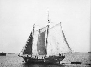
Lane undoubtedly saw Chebacco Boats in the years prior to his move to Boston, but if he made drawings or paintings of them in that period, none have come to light. A small lithograph, titled “View of the Old Fort and Harbor 1837,” is attributed to him, but the vessels and wharf buildings are too crudely drawn to warrant this undocumented claim. (3) Lane did see and render accurately the Chebacco Boat’s successor the Pinky—which was larger and had a schooner rig (two masts, main sail, fore sail, jib, and main topmast staysail).
Schooners with pinksterns were recorded early in the 18th century later that there were models and graphic representations of hull form and rig (Ref. 4). By then, the pinky was very similar in hull form to Chebacco Boats, and some Chebacco Boats were converted to pinkies by giving them schooner rigs. A pinky in Lane’s The Old Fort and Ten Pound Island, Gloucester, 1850s (inv. 30) (misdated 1850s, more likely mid-1840s) is quite possibly an example of such a conversion.
Lane’s depictions of pinkies in Massachusetts waters are numerous and sometimes very informative. Examples in his views of Gloucester Harbor portray them at various angles, from broadside (see Gloucester Harbor from Rocky Neck, 1844 (inv. 14), The Old Fort and Ten Pound Island, Gloucester, 1850s (inv. 30), and View of the Town of Gloucester, Mass., 1836 (inv. 86)) to stern (see The Western Shore with Norman's Woe, 1862 (inv. 18), The Old Fort and Ten Pound Island, Gloucester, 1850s (inv. 30), and Gloucester Harbor, 1850s (inv. 391)), but few, if any, bow views. His portrayals of pinkies in Boston Harbor and vicinity are more in the foreground and more generous in detail. The earliest of these, from 1845, shows a pinky getting underway in a hurry as the yacht "Northern Light" bears down on her in The Yacht "Northern Light" in Boston Harbor, 1845 (inv. 268). A late harbor view (id ) offers a rare bow view.
Like the Chebacco Boat, the pinky was primarily a fishing vessel, doing much the same kind of fishing in coastal waters, but large enough to venture further offshore to work on the banks in the Gulf of Maine in pursuit of the cod. By the 1820s, pinkies reached their largest size: 50 to 60 feet on deck. Beyond that size called for a different deck arrangement and higher rails, so men could stand on deck and fish from the rails – an arrangement offered by the banks fishing schooner. (5)
What is perhaps Lane’s most detailed and narrative view of a pinky appears in Becalmed Off Halfway Rock, 1860 (inv. 344) and dominates the right foreground. Fitted-out for mackerel gillnetting, she has a dory and a wherry in tow, the latter with the net in the stern. The crew is relaxed, enjoying the evening calm as the vessel heads for port. The barrels on deck are filled with freshly caught mackerel, which will be sold as such when landed, most likely at Gloucester. This pinky was probably fishing on Stellwagen Bank or Cape Cod Bay, which were good fishing grounds for mackerel, and close enough to Gloucester to make trips in smaller vessels worthwhile. To judge from his paintings, Lane found only a few pinkies in the parts of the Maine Coast he explored. Only one drawing (Southwest Harbor, Mount Desert, 1852 (inv. 184)) and two widely published paintings (Entrance of Somes Sound, Mount Desert, Maine, 1855 (inv. 347) and Bar Island and Mt. Desert Mountains from Somes Settlement, 1850 (inv. 401)) illustrate this type, and then at a distance. What is apparent is that pinkies in southern Maine did not differ markedly from those on the Massachusetts coast. Had Lane ventured further Down East, he might have found modifications to the type that reflected Canadian influences. (6)
– Erik Ronnberg
References:
1. William A. Baker, Sloops & Shallops (Barre, MA: Barre Publishing Co., 1966), 82–91; and Howard I. Chapelle, The American Fishing Schooners, 1825–1935 (New York: W.W. Norton & Co., 1973), 25–27.
2. G. Brown Goode, The Fisheries and Fishery Industries of the United States, Section V, Vol. I (Washington, DC: Government Printing Office, 1884–87), 275, 287, 298–300, 419–21, 425–32, 459–63.
3. John J. Babson, History of the Town of Gloucester, Cape Ann (Procter Bros., 1860, reprint: Gloucester, MA: Peter Smith, 1972), see lithograph facing p. 474.
4. Goode, 275–77, 280, 294–96.
5. Chapelle, 36–37.
6. Ibid., 45–54.
Glass plate negative
3 x 4 in.
Cape Ann Museum Library & Archive
#10112
Also filed under: Gloucester Harbor, Inner / Harbor Cove »
Also filed under: Ship Models »
Also filed under: Ship Models »
Also filed under: Ship Models » // Small Craft – Wherries, and Dories »
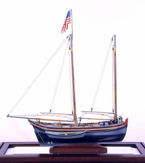
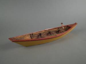
20" l. x 19" h. x 3 3/4" w. [not to scale]
Cape Ann Museum. Gift of Mr. J. Hollis Griffin, 1940 (891)
"Pinkys" were early nineteenth-century schooner-rigged derivations of Chebacco boats. This model is a good example of a traditional “sailor’s model,” or in this case, a sailmaker’s model, Mr. Nickerson having been a sailmaker.
Also filed under: Ship Models »


1860 In John J. Babson, History of the Town Gloucester (Gloucester, MA: Procter Brothers, 1860) Cape Ann Museum Library & Archives, Gloucester, Mass.
See p. 474.
View related catalogue entries (4) »
Also filed under: Babson History of the Town of Gloucester » // Fort (The) and Fort Point » // Gloucester Harbor, Inner / Harbor Cove » // Gloucester, Mass. - "Ten Pound Island Light » // Schooner (Coasting / Lumber / Topsail / Packet / Marsh Hay) » // Ten Pound Island »
"Party boat" is a colloquial term for any kind of small craft adapted or used for taking guests (customarily for hire) on sightseeing trips or fishing for pleasure. (1) The term survives to this day on Cape Ann and other places for vessels engaged in the same activities. (2) In Lane's time, party boating was a calling of opportunity, and a fisherman's boat might be used in season - regularly or occasionally - to take "rusticators" fishing. Likewise, a boat used for its owner's own pleasure might be hired to take sightseers sailing for an afternoon. The latter use is seen in Lane's 1844 view of Gloucester Harbor from Rocky Neck (see the yawl-rigged sailboat in the foreground of Gloucester Harbor from Rocky Neck, 1844 (inv. 14)).
By the early 1850s, summer visitor activity, encouraged by the building of the Pavilion Hotel on Gloucester's waterfront, led to increased pleasure boating activity, if Lane's painting Gloucester Harbor, 1852 (inv. 38) of Pavilion Beach and Sidney Mason's hotel is any indication. (3) Lane's Gloucester Harbor scenes from this decade show a number of pleasure craft suitable for taking passengers for hire (see Fresh Water Cove from Dolliver's Neck, Gloucester, Early 1850s (inv. 45), Coming Ashore near Brace's Rock, Gloucester, Massachusetts, c.1860 (inv. 60), and View of Gloucester from "Brookbank," the Sawyer Homestead, c.1856 (inv. 95)). Small working craft suitable for this purpose are seen in The Old Fort and Ten Pound Island, Gloucester, 1850s (inv. 30), Gloucester Harbor, 1852 (inv. 38) (right foreground), View of Gloucester, 1859 (inv. 91) (foreground), and Watch House Point, 1860 (inv. 292) (right foreground). In View of Gloucester Harbor, 1848 (inv. 97), we see passengers boarding a small sloop-rigged boat hidden by the rocks at Duncan's Point (left middle ground).
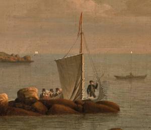
In coastal waters south of Gloucester, a few of Lane's paintings offer pleasure craft as candidates for taking paying passengers. Phantom of Boston, c.1850s (inv. 574) depicts a cruising yawl "Phantom" of Boston, beached with hunting gear unloaded alongside while two of the crew await an approaching party in a rowing boat. The location is unidentified, but a possibility is the barrier beach around the marshes of Lynn, Massachusetts, which were once very popular hunting grounds for migrating waterfowl. A second candidate is a small sloop with a party of four on an evening sail off Halfway Rock in Becalmed Off Halfway Rock, 1860 (inv. 344) (far right).
Lane found similar uses of working watercraft in Maine, where the families of a small coastal community would travel by their workboats to a gathering place for a clambake or similar festive outing (see View of Indian Bar Cove, Brooksville, Maine, 1850 (inv. 61)). The artist became a "rusticator" himself when he, Joseph Stevens, and friends explored Mount Desert Island and vicinity in the "General Gates," a sloop-rigged Maine version of a New England Boat (View of Bar Island and Mount Desert Mountains, from the Bay in Front of Somes Settlement, 1850 (inv. 177) and Castine Harbor and Town, 1851 (inv. 272)).
When Lane traveled to New Bedford in 1856 to observe and sketch a regatta held by the New York Yacht Club, he observed and sketched it while on board an unknown vessel near the starting and finishing line, formed by the race committee boat "Emblem" and her yawl-boat.
Close by was a small party boat with observers on board, probably a fishing sloop, given its work-a-day looks. In the ensuing year, Lane painted four detailed views of this race, the party boat appearing in New York Yacht Club Regatta (1), 1856 (inv. 66) (right foreground); New York Yacht Club Regatta (2), 1856 (inv. 270) (right margin); New York Yacht Club Regatta (3), After 1856 (inv. 396) (center); and New York Yacht Club Regatta (4), 1857 (inv. 397) (left foreground). (4)
– Erik Ronnberg
References:
1. M. H. Parry and others, Aak to Zumbra: A Dictionary of the World's Watercraft (Newport News, VA: The Mariners' Museum, 2000), 436.
2. Ibid.
3. Proctor's Able Sheet (a Gloucester newspaper), January 1857: "Gloucester House reopened—refitted—boats always ready to take parties cruising or fishing..."
4. John Wilmerding, Fitz Henry Lane, 2nd ed. (Cape Ann, MA: Cape Ann Historical Association, 2005), 52–54. Lane's 1852 cruise in the Mount Desert region in the sloop "Superior" was reprinted as an appendix to Wilmerding's essay in Paintings by Fitz Hugh Lane (Washington, DC: National Gallery of Art, 1988), 125–26.
Oil on canvas
34 x 45 3/4 in.
Cape Ann Museum, Gloucester, Mass., Gift of Mrs. Jane Parker Stacy (Mrs. George O. Stacy),1948 (1289.1a)
Detail of party boat.
Also filed under: Gloucester Harbor, Inner / Harbor Cove »

Oil on canvas
22 x 36 in.
Cape Ann Museum, Gloucester, Mass., deposited by the Collection of Addison Gilbert Hospital, 1978 (DEP. 201)
Detail of party boat.
Also filed under: Ten Pound Island »
Newspaper
Ad in Gloucester Telegraph
FISHING AND SAILING PARTIES
"Persons desirous of enjoying a SAILING or FISHING EXCURSION, are informed that the subscriber will be in readiness with the Boat EUREKA, to attend to all who may favor him with their patronage. JOHN J. FERSON"
Also filed under: Gloucester Harbor – Use » // Newspaper / Journal Articles »
Newsprint
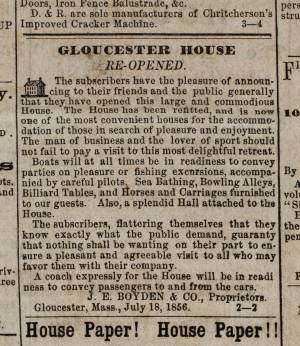
Ad for Gloucester House
Courtesy of the American Antiquarian Society, Worcester, Mass.
See p. 4, column 2.
Also filed under: Brick Houses / Gloucester House Hotel » // Newspaper / Journal Articles »
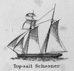
Schooners in Lane’s time were, with few exceptions, two-masted vessels carrying a fore-and-aft rig having one or two jibs, a fore staysail, gaff-rigged fore- and main sails, and often fore- and main topsails. One variant was the topsail schooner, which set a square topsail on the fore topmast. The hulls of both types were basically similar, their rigs having been chosen for sailing close to the wind. This was an advantage in the coastal trade, where entering confined ports required sailing into the wind and frequent tacking. The square topsail proved useful on longer coastwise voyages, the topsail providing a steadier motion in offshore swells, reducing wear and tear on canvas from the slatting of the fore-and-aft sails. (1)
Schooners of the types portrayed by Lane varied in size from 70 to 100 feet on deck. Their weight was never determined, and the term “tonnage” was a figure derived from a formula which assigned an approximation of hull volume for purposes of imposing duties (port taxes) on cargoes and other official levies. (2)
Crews of smaller schooners numbered three or four men. Larger schooners might carry four to six if a lengthy voyage was planned. The relative simplicity of the rig made sail handling much easier than on a square-rigged vessel. Schooner captains often owned shares in their vessels, but most schooners were majority-owned by land-based firms or by individuals who had the time and business connections to manage the tasks of acquiring and distributing the goods to be carried. (3)
Many schooners were informally “classified” by the nature of their work or the cargoes they carried, the terminology coined by their owners, agents, and crews—even sometimes by casual bystanders. In Lane’s lifetime, the following terms were commonly used for the schooner types he portrayed:
Coasting schooners: This is the most general term, applied to any merchant schooner carrying cargo from one coastal port to another along the United States coast (see Bar Island and Mt. Desert Mountains from Somes Settlement, 1850 (inv. 401), right foreground). (4)
Packet schooners: Like packet sloops, these vessels carried passengers and various higher-value goods to and from specific ports on regular schedules. They were generally better-maintained and finished than schooners carrying bulk cargoes (see The Old Fort and Ten Pound Island, Gloucester, 1850s (inv. 30), center; and Gloucester Inner Harbor, 1850 (inv. 240), stern view). (5)
Lumber schooners: Built for the most common specialized trade of Lane’s time, they were fitted with bow ports for loading lumber in their holds (see View of Southwest Harbor, Maine: Entrance to Somes Sound, 1852 (inv. 260)) and carried large deck loads as well (Stage Rocks and the Western Shore of Gloucester Outer Harbor, 1857 (inv. 8), right). Lumber schooners intended for long coastal trips were often rigged with square topsails on their fore masts (see Becalmed Off Halfway Rock, 1860 (inv. 344), left; ; and Lumber Schooner in a Gale, 1863 (inv. 552)). (6)
Schooners in other specialized trades. Some coasting schooners built for carrying varied cargoes would be used for, or converted to, special trades. This was true in the stone trade where stone schooners (like stone sloops) would be adapted for carrying stone from quarries to a coastal destination. A Lane depiction of a stone schooner is yet to be found. Marsh hay was a priority cargo for gundalows operating around salt marshes, and it is likely that some coasting schooners made a specialty of transporting this necessity for horses to urban ports which relied heavily on horses for transportation needs. Lane depicted at least two examples of hay schooners (see Gloucester Harbor, 1850s (inv. 391), left; and Coasting Schooner off Boon Island, c.1850 (inv. 564)), their decks neatly piled high with bales of hay, well secured with rope and tarpaulins.
– Erik Ronnberg
References:
1. Howard I. Chapelle, The History of American Sailing Ships (New York: W.W. Norton & Co., 1935), 258. While three-masted schooners were in use in Lane’s time, none have appeared in his surviving work; and Charles S. Morgan, “New England Coasting Schooners”, The American Neptune 23, no. 1 (DATE): 5–9, from an article which deals mostly with later and larger schooner types.
2. John Lyman, “Register Tonnage and its Measurement”, The American Neptune V, nos. 3–4 (DATE). American tonnage laws in force in Lane’s lifetime are discussed in no. 3, pp. 226–27 and no. 4, p. 322.
3. Ship Registers of the District of Gloucester, Massachusetts, 1789–1875 (Salem, MA: The Essex Institute, 1944). Vessels whose shipping or fishing voyages included visits to foreign ports were required to register with the Federal Customs agent at their home port. While the vessel’s trade or work was unrecorded, their owners and master were listed, in addition to registry dimensions and place where built. Records kept by the National Archives can be consulted for information on specific voyages and ports visited.
4. Howard I. Chapelle, The National Watercraft Collection (Washington, DC: Smithsonian Institution, 1960), 40, 42–43.
5. Ibid., 42–43, 73.
6. Ibid., 74–76.
In R. H. Dana, The Seaman's Friend, 13th ed. (Thomas Groom & Co. Publisher, 1873)
A topsail schooner has no tops at her foremast, and is fore-and-aft rigged at her mainmast. She differs from an hermaphrodite brig in that she is not properly square-rigged at her foremast, having no top, and carrying a fore-and-aft foresail instead of a square foresail and a spencer.

Detail views: marine railway and hauling cradle for vessel Wood rails, metal rollers, chain; wood cradle. Scale: ½" = 1' (1:24) Original diorama components made, 1892; replacements made, 1993. Cape Ann Museum, from Gloucester Chamber of Commerce, 1925 (2014.071)
A schooner is shown hauled out on a cradle which travels over racks of rollers on a wood and metal track.
Also filed under: Burnham Brothers Marine Railway » // Marine Railways »

c. 1900 Glass plate negative Collection of Erik Ronnberg
Also filed under: Lobstering »
"The Maine Register for the Year 1855, embracing State and County Officers, and an abstract of the law and resolves; together with a complete business directory of the state, and a variety of useful information."
Details about Maine's lumber trade in 1855, see pp. 250–52
Also filed under: Castine » // Lumber Industry »
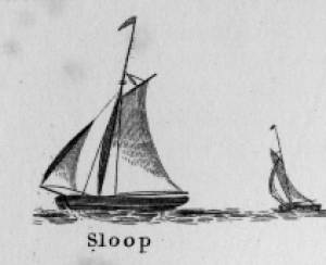
Sloops are one-masted sailing vessels which, in American examples, set fore-and-aft sails but usually no square sails. Thus, staysails, or jibs, are set from the fore stay(s) and a quadrilateral mainsail is set from the mast and spread by a gaff and a boom. The larger sloops would often set a triangular topsail over the main sail. (1)
The sloops depicted by Lane were used in various coastal trades, each with its own requirements, which dictated the sizes and details of their hulls and rigs. Most elegant were the packet sloops, which transported passengers, mail, and higher value goods between specific ports on regular schedules. They usually measured between sixty and seventy-five feet on deck, as dictated by anticipated shipping volume. Finely finished, they usually had stern galleries—a row of windows across the transom with ornamental moldings—and varied color schemes. Examples of packet sloops are in Gloucester Harbor from Rocky Neck, 1844 (inv. 14) (center, middle ground) and Study of Ships, 1851 (inv. 141) (foreground), both of which probably made trips between Gloucester and Boston, or Gloucester and Newburyport. (2)
Another specialized sloop of similar size was the stone sloop, used to ship granite blocks from stone-loading piers around Cape Ann to other ports. They were similar in rig to packet sloops, but of heavier construction with greater hold capacity and absence of decoration. Their stout appearance was augmented by simple color schemes, or even tarred topsides, reflecting the wear and strain imposed by their heavy cargos. Lane depicted these vessels in his painting of Fresh Water Cove from Dolliver's Neck, Gloucester, Early 1850s (inv. 45), with a sloop (at left) preparing to load at wharf-side, and another (at right) sailing out with a cargo. (3)
Sloops of the more work-a-day sort are the most commonly seen examples in Lane’s paintings, most of them appearing in his views of Boston Harbor. Usually deep-loaded and looking weather-worn, they contrast sharply with the packet- and clipper ships which dominate the scene. Sloops of this type are rarely seen in Lane’s paintings of Gloucester Harbor and the Maine coast, although they were certainly needed for short-distance transportation (see Bear Island, Northeast Harbor, 1855 (inv. 24), View of Camden Mountains from Penobscot Bay, c.1852 (inv. 207), Sunrise on the Maine Coast, Mount Desert Island, 1856 (inv. 295)). For coastal Maine, lack of railroads for heavier freight and greater distances between ports made the use of schooners with larger carrying capacity a greater necessity. (4)
In Lane’s views of New York Harbor, a regional sloop variant, the Hudson River Sloop, appears in New York Harbor, c.1855 (inv. 46) (bow view, left) and A Calm Sea, c.1860 (inv. 6) (stern view, right). This type had become prominent in the Hudson River packet trade between New York City, Albany, and beyond to points north and west as far as the eastern terminus of the Erie Canal. Large vessels for their rigs, they were well-finished and well-kept, reflecting pride of ownership and rivalry among their owners and crews. (5)
– Erik Ronnberg
References:
1. A Naval Encyclopaedia (Philadelphia: L.R. Hamersly & Co., 1884. Reprint: Detroit, MI: Gale Research Company, 1971), 59. See first definition of "sloop" and definition of "sloop-rigged."
2. Robert Greenhalgh Albion, William A. Baker, and Benjamin Woods Labaree, New England and the Sea (Mystic, CT: Mystic Seaport Museum, 1972; reprinted in 1994), 127–28.
3. Howard I. Chapelle, The History of American Sailing Ships (New York: W.W. Norton & Co., 1935), 300–02.
4. Ibid., 300.
5. Ibid., 298–300.
A Naval Encyclopaedia:
Dictionary of nautical words and phrases
Special Articles on Naval Art and Science
Philadelphia: L.R. Hamersly & Co.
'Mudian, "Mugian, or Bermudian. A boat special to the Bermuda islands, usually decked, with the exception of a hatch; from 2 to 20 tons burden; it is short, of good beam, and great draft of water abaft, the stem and keel forming a curved line. It carries an immense quantity of ballast. Besides a long main- and short jib-boom, it has a long, taperking, raking mast, stepped just over the forefoot, generally unsupported by shrouds or stays; on it a jib-headed mainsail is hoisted to a height of twice, and sometimes three times, the length of the keel. This sail is triangular, stretched at its foot by a long boom. The only other sail is a small foresail or jib. They claim to be the fastest craft in the world for working to windward in smooth water, it being recorded of one that she made five miles dead to windward in the hour during a race; and though they may be laid over until they fill with water, they will not capsize.
St. George's Historical Society
Detail of painting of St. George's Harbour, Bermuda, during US Civil War, with a Confederate blockade runner anchored in the foreground.
Also filed under: Puerto Rico »
Wood, metal, cordage, cloth, paint.
Scale: ¼ in. = 1ft. (1:48)
Cape Ann Museum. Gift of Roland and Martta Blanchet (1997.17.3)
Although built in 1890 and larger than the stone sloops of Lane’s time, the "Albert Baldwin’s" hull form, rig, and loading boom are very similar to those of the 1840s and 1850s.
Also filed under: Granite Quarrying / Shipping » // Ship Models »
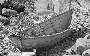
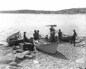
The term “wherry”—variously spelled—has a long history with many hull types, some dating from the fifteenth century. (1) The version known to Lane appears to be a variant of the dory hull form and probably was developed by French and English fishermen in the Newfoundland fisheries before 1700. (2) From that time, the wherry and the dory co-evolved, their similarities the result of their construction, their differences the result of use. By the early nineteenth century, their forms reached their final states, if fragments of contemporary descriptions are any indication. (3)
By the time Lane was depicting wherries, the type (as used for fishing) resembled a larger, wider version of a dory. The extra width was due to greater bottom width (both types had flat bottoms), with a wider transom at the stern instead of the narrow, v-shaped “tombstone.” These features are easy to see in one of his drawings (see Three Men, One in a Wherry, n.d. (inv. 225)) and a painting (see Sunrise through Mist, 1852 (inv. 98)), the latter depicted alongside a dory, clearly showing the differences.
No published descriptions of the uses of wherries on Cape Ann in Lane’s time have come to light, but an example in broadside view offers one use. In Becalmed Off Halfway Rock, 1860 (inv. 344), a pinky (in right foreground) has a dory and a wherry in tow, the latter loaded with a gill net for catching mackerel. (4) The greater size of the wherry is required for stowing the net, as well as setting it while the dory tows away one end to set it in way of the mackerel school.
In Lane’s time, wherries would have been used where bulky gear was called for in the coastal fisheries, i.e. gill nets, and fish traps such as pound nets, fyke nets, and lobster traps. Migrating fish schools (herring, mackerel) and shellfish were the target species.
The dory’s development was first dictated by its use in shore fishing, where small size and light weight made it easy to maneuver around rocks and shallows, and to haul ashore at the end of a day’s work. Its simple design made it easy and cheap to build. This is borne out by the standardized construction and sizes used by Simon Lowell’s boat shop at Salisbury Point, Massachusetts at the turn of the nineteenth century. Lowell called his boats “wherries,” but in Swampscott, Massachusetts, the fishermen, who used them called them “dories,” which may mark the beginning of the latter term’s wider use. (5)
The dories we see in Lane’s paintings are in virtually every way like the ones we know today. One of the best examples (see View from Kettle Cove, Manchester-by-the-Sea, 1847 (inv. 94)) even shows interior detail, including frames, leaving no doubt about its construction. Other good examples are found in Salem Harbor, 1853 (inv. 53), View of Gloucester Harbor, 1848 (inv. 97), and Sunrise through Mist, 1852 (inv. 98).
For inshore fishing, dories were used to catch mackerel and herring, either with hook and line or with small nets. Hooks and line were used for flat fish (flounder, dab, and fluke), rock cod, hake, and cunner. Eels were speared (see View from Kettle Cove, Manchester-by-the-Sea, 1847 (inv. 94)), clams were dug, and lobsters trapped. In Lane’s later years, the use of dories in trawling (setting long “trawl lines” with many baited hooks) was in its earliest. This method required six to ten dories carried on board a schooner to fish on the distant banks off New England and Canada. Early records of dory trawling in New England are fragmentary, giving the mid-1840s as the time of introduction. (6) The Gloucester-owned schooner "Anna" made a successful dory trawling trip to the Grand Banks in 1854, but no depiction of this vessel by Lane has been found or recorded. (5) Despite successful early efforts, dory trawling from Gloucester was slow to be accepted, and the fishery had very limited growth prior to 1860. (7)
– Erik Ronnberg
References:
1. M.H. Parry et al., Aak to Zumbra (Newport News, VA: The Mariners’ Museum, 2000), 634.
2. John Gardner, The Dory Book (Camden, ME: International Marine Publishing Company, 1978), 5–9.
3. Ibid., 25–29.
4. John Wilmerding, ed., Paintings by Fitz Hugh Lane (Washington, DC: National Gallery of Art, 1988), 89, 92. The “possibly discarded whaleboat” is definitely a wherry.
5. Gardner, 9, 10.
6. Wesley George Pierce, Goin’ Fishin’ (Salem, MA: Marine Research Society, 1934), 63–64.
7. Raymond McFarland, A History of New England Fisheries (Philadelphia: University of Pennsylvania, 1911), 279.

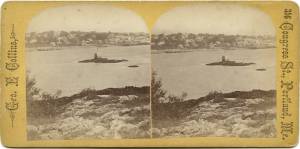
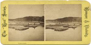
c.1870 Stereograph card Procter Brothers, Publisher Cape Ann Museum Library & Archive
"Gloucester Harbor from Rocky Neck, Looking Southwest. This gives a portion of the Harbor lying between Ten Pound Island and Eastern Point. At the time of taking this picture the wind was from the northeast, and a large fleet of fishing and other vessels were in the harbor. In the range of the picture about one hundred vessels were at anchor. In the small Cove in the foreground quite a number of dories are moored. Eastern Point appears on the left in the background."
Southeast Harbor was known for being a safe harbor.
Also filed under: Gloucester Harbor, Outer » // Historic Photographs » // Rocky Neck » // Schooner (Fishing) »
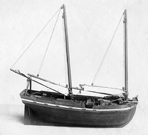
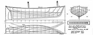
Also filed under: Chebacco Boat / Dogbody / Pinky » // Ship Models »
Gloucester, MA
4 x 33 1/2 x 7 1/4 in (10.16 x 85.09 x 18.415 cm)
Peabody Essex Museum
Also filed under: Objects » // Ship Models »
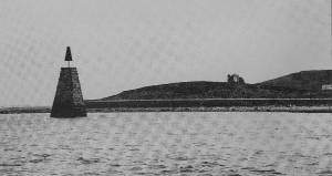
A "spindle" is a fixed marker to indicate a hazard to navigation (such as a rock which couldn't be seen at high tide). It serves the same purpose as a channel buoy, a "light beacon," or a “monument,” to warn vessels away from dangerous places or stretches of coastline. Spindles are usually iron rods with some sort of geometric object (round, flat, or triangular) on top, brightly painted (usually red) for visibility. Monuments, like the ones you see in Lane’s depictions of Half Way Rock or Norman’s Woe Reef, were made of stone and look like stumpy obelisks—or grave monuments. They were also essential as reference points for the early coastal surveys in their efforts to make more accurate charts.
In Castine, the notable square monument in the center of the harbor marked Hosmer's Ledge.

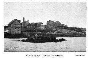
Photograph in The Illustrated Coast Pilot with Sailing Directions. The Coast of New England from New York to Eastport, Maine including Bays and Harbors, published by N. L. Stebbins, Boston
Also filed under: Gloucester Harbor, Inner / Harbor Cove »

Pencil and ink on paper
15 x 22 1/8 in.
Cape Ann Museum, Gloucester, Mass., Gift of Mr. Donald K. Usher, in memory of Mrs. Margaret Campbell Usher, 1984 (2401.19)
Also filed under: Gloucester Harbor, Outer » // Mackerel Fishing »
Stereograph card Castine Historical Society Collections (1996.1)
View related catalogue entries (2) »
Also filed under: Castine » // Historic Photographs »
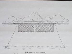
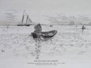
Gill netting is a fishing method wherein a fish swims into a net, entangling its gill covers in the mesh and is thus unable to free itself. This method works especially well with smaller species (mackerel and herring) which swim in large schools near the surface and are caught in large numbers. Gill nets with larger mesh sizes have caught larger species, such as cod, but under special situations and with nets set at various depths. These nets came to the fisheries in the 1870s, the nets of Lane's time being set on the surface with wooden floats on their surface edges and weights on their bottom edges.
Lane's depiction of gill netting in Gloucester Harbor in the foreground of Gloucester Harbor, 1852 (inv. 38) could be for either mackerel or herring. A yawl boat (with sail) and a wherry are working with two separate nets which will probably be connected when the wherry has completed setting the one at left. The second net was probably set after the size and direction of the school was determined.
Gill netting in Ipswich Bay was done on a larger scale, using larger nets and larger boats. It was usual practice to leave the nets set overnight, hauling them at midnight and again in the morning. Night haulings involved the use of torches, whose light was a strong attraction to the fish and could significantly improve the catch. Ipswich Bay was lit up over much of its expanse by these lights on a busy summer night.
– Erik Ronnberg
In G. Brown Goode, The Fisheries and Fishery Industries of the United States (Washington, DC: Government Printing Office)
Cape Ann Museum Library & Archive, Gloucester, Mass.
Also filed under: Fishing »
In G. Brown Goode, The Fisheries and Fishery Industries of the United States (Washington, DC: Government Printing Office)
See pl. 45.
Underrunning cod gill-nets in Ipswich Bay, Mass.
Also filed under: Fishing »
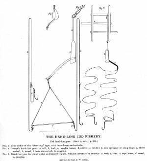
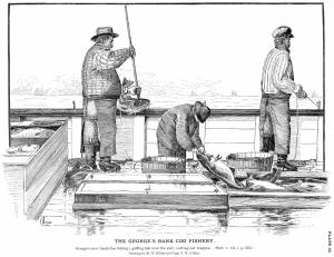
"Hand-lining" was fishing with a single line which had one or sometimes two hooks, as opposed to "trawling," in which a single line had many hooks. Hand-lining was the exclusive American fishing method from colonial times to the mid-19th century, and continued in use, taking second place to dory trawling only after the Civil War. Even then, it persisted into the twentieth century for some offshore fishing grounds, while hand-lining from dories remained a favored method for the shore fisheries.
Hand-line fishing on the offshore banks was done in relatively shallow water (10 to 45 fathoms), often over rocky bottom. This method depended on catching fish at mid-levels as well as on the bottom, hence the lines were relatively short, seldom longer than 75 fathoms. Each fisherman worked two lines, fishing from the schooner's rail. Bait could be salted clams, fresh-caught squid, and even birds.
Hand-lining by American schooners on the Grand Banks declined in the 1830s as they turned to Georges Bank to exploit that neglected resource. In doing so, they turned to a highly modified hand-lining gear using two hooks on a single line. The hooks were on a pair of long gangings (leaders), joined at the sinker and spread apart 12 to 18 inches by a metal rod (or wooden spreader) called a "sling ding." The hand-line itself was much longer - as much as 900 feet, allowing the gear to cover a broad area over a shallow sandy bottom with few obstructions.
On Georges Bank, the schooners anchored where the wind would set the vessels broadside to tidal currents, with the crew fishing from the down-current side. This allowed the lines to be paid out without getting tangled with each other or bunching up astern. The long hand-lines, combined with heavy sinkers and (hopefully) two large cod on the hooks made for strenuous hauling, made all the more so by the tidal current. Georges fishermen were regarded as the strongest in the Cape Ann fisheries.
The wealth of resources and the proximity of Georges Bank was offset by its hazards in heavy weather, as many of Gloucester's widows could testify. Breaking shallows, mountainous waves and winter storms took their toll, but this danger was compounded when numerous vessels anchored within sight of each other. A parted anchor cable could send a vessel crashing into another with the loss of both with their crews.
Steel engraving after drawing in G. Brown Goode, The Fisheries and Fishery Industries of the United States (Washington, DC: Government Printing Office)
8 1/2 x 11 in. (page size)
Cape Ann Museum Library & Archive, Gloucester, Mass.
See pl. 31.
Shows the two basic types of hand-line gear in use in mid-ninteenth century. At left is the Georges gear, developed for fishing on Georges Bank. At right is shoal water gear, as commonly used in the inshore fisheries using dories and other small craft. The spreader, or "sling-ding" was used on this type of gear with the advent of dory hand-lining on offshore grounds.
Also filed under: Cod / Cod Fishing »
Steel engraving after drawing in G. Brown Goode, The Fisheries and Fishery Industries of the United States (Washington, DC: Government Printing Office, 1883)
8 1/2 x 11 in. (page size)
Cape Ann Museum Library & Archive, Gloucester, Mass.
See pl. 32.
Also filed under: Cod / Cod Fishing » // Georges Bank, Mass. »
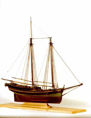
Model made for marine artist Thomas M. Hoyne
scale: 3/8" = 1'
Thomas M. Hoyne Collection, Mystic Seaport, Conn.
While this model was built to represent a typical Marblehead fishing schooner of the early nineteenth century, it has the basic characteristics of other banks fishing schooners of that region and period: a sharper bow below the waterline and a generally more sea-kindly hull form, a high quarter deck, and a yawl-boat on stern davits.
The simple schooner rig could be fitted with a fore topmast and square topsail for making winter trading voyages to the West Indies. The yawl boat was often put ashore and a "moses boat" shipped on the stern davits for bringing barrels of rum and molasses from a beach to the schooner.
– Erik Ronnberg
References:
Jeffrey Bolster, Black Jacks: African American Seafarers in the Age of Sail (Cambridge, MA: Harvard University Press, 1997).
Howard I. Chapelle, American Small Sailing Craft (New York: W.W. Norton & Co., 1951), 29–31.
Also filed under: Schooner (Fishing) » // Ship Models »
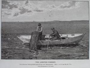
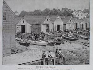
Prior to 1840, the lobster fishery had but a minor role in the American fishing industry. The market was limited by the difficulties of transporting live lobsters over long distances, which kept the demand local. As transportation (by rail), improved, the market broadened and demand increased, leading to more fishing and reduction of lobsters, both in size and in numbers.
In Lane's later years, the fishery was growing, but significant decreases of lobsters were not yet considered serious. Decrease in numbers of very large lobsters (weighing ten pounds or more) was noted, but clamors for regulations on sizes and numbers of lobsters caught were not heard until the 1870s.
Lobster traps in the nineteenth century were mostly of the "round top" design—built of wooden laths with funnel-shaped entries of netting at both ends. The tops were hinged "lids" providing access to the catch; stones were fitted as weights to the flat bottom.
The pots could be set individually or in "strings" with marker buoys at both ends of the string. Individual pots were set on rocky bottom where a string of pots could become fouled and lost. Strings of pots were best for a smooth bottom when lobsters were moving inshore in large numbers. When lobsters were scarce on smooth bottoms, individual pots were set, being easier to move to other places.
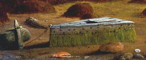
Once caught, lobsters were kept in floating boxes (called "cars") with open seams and bored holes to allow water to circulate. A lobster car with a "killick" (stone anchor) is depicted by Lane in the foreground of Gloucester Inner Harbor, 1850 (inv. 240).
– Erik Ronnberg
Reference:
G. Brown Goode, "Fisheries and Fishery Industries", Section V, Vol. 2, 658–74.
In G. Brown Goode, The Fisheries and Fishery Industries of the United States (Washington, DC: Government Printing Office)
Cape Ann Museum Library & Archive, Gloucester, Mass.
See pl. 247.
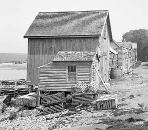
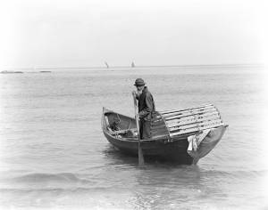
This photo was most likely taken in Ipswich Bay on the north shore of Cape Ann (visible in right background). During the warm months, lobsters migrate to the shore where they feed and shed their outgrown shells while hiding among the rocks. Dories are the lobstermen's choice for working traps out in the bay or close to shore in rocky shallows. Pots can be set individually or in strings, the latter on smoother ground where the line is less likely to be fouled.
– Erik Ronnberg
Gloucester Inner Harbor
Oil on canvas
24 x 36 in. (61 x 91.4 cm)
The lobster car was a floating holding tank for lobsters that were kept in the harbor prior to local sale or transportation to fish markets in Boston.
In G. Brown Goode, The Fisheries and Fishery Industries of the United States (Washington, DC: Government Printing Office)
Cape Ann Museum Library & Archive, Gloucester, Mass.
See pl. 249.
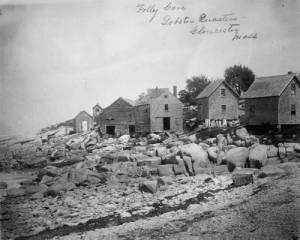
Lobster Cove (Lane's Cove) was a thriving port for the Ipswich Bay shore fisheries from colonial times through the 19th century. Even as late as the mid-20th century, the waterfront was lined with sheds for fishing gear - now all gone. In addition to lobstering, gill-netting, trap fishing, hand-lining, and seining (small-scale) were carried on at various times in pursuit of numerous fish and shellfish types.
– Erik Ronnberg
Also filed under: Folly Cove »
Glass plate negative
4 x 5 in.
Cape Ann Museum Library & Archive
#10205/418
Also filed under: Folly Cove »
c. 1900 Glass plate negative Collection of Erik Ronnberg
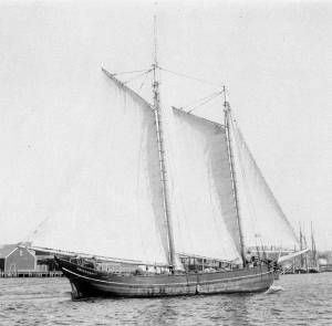
Also filed under: Schooner (Coasting / Lumber / Topsail / Packet / Marsh Hay) »
The timber trade played an important role in New England’s economy from Colonial days through the mid-19th century, supplying the vast quantities of lumber which a rapidly growing nation demanded. While Cape Ann’s woodlands were depleted early on, timber continued to be harvested from northern New England and the Maritime Provinces right up to the Civil War.
With a deep and safe harbor, Gloucester often served as a layover spot where vessels bound from Maine to Boston, New York or Baltimore and heavily laden with lumber could ride out bad weather. Because of this, Fitz Henry Lane’s paintings of Gloucester Harbor often show a schooner or a brig, loads of lumber clearly visible on their decks, sheltering along the Western Shore.
References:
Honey, Mark E., "King Pine, Queen Spruce, Jack Tar," An Intimate History of Lumbering on the Union River, Volumes 1-5. This source, in its entirety, lays down the foundation of Downeast Maine's unique culture which was built upon pine lumber and timber, the cod fisheries, coasting, shipbuilding, and the interrelationships of family and community.

1852 Photograph
Also filed under: Schooner (Coasting / Lumber / Topsail / Packet / Marsh Hay) »
Advertisement for The Bangor News Company, est. January 31, 1881 Castine Historical Society Collections (2008.02)
Also filed under: Historic Photographs »
"The Maine Register for the Year 1855, embracing State and County Officers, and an abstract of the law and resolves; together with a complete business directory of the state, and a variety of useful information."
Details about Maine's lumber trade in 1855, see pp. 250–52
Also filed under: Castine » // Schooner (Coasting / Lumber / Topsail / Packet / Marsh Hay) »