loading 
Fitz Henry Lane
HISTORICAL ARCHIVE • CATALOGUE RAISONNÉ • EDUCATIONAL RESOURCE
An online project under the direction of the CAPE ANN MUSEUM
An online project under the direction of the CAPE ANN MUSEUM
Catalog entry
inv. 109
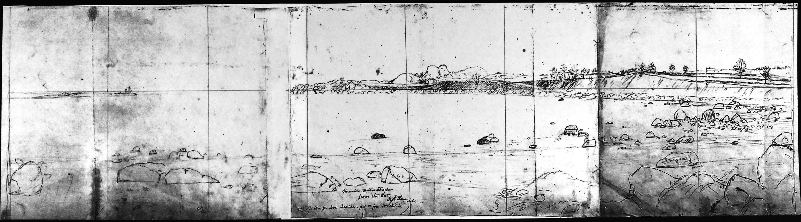
Gloucester Outer Harbor, from the Cut
1850s Graphite on paper (2 sheets) 10 1/2 x 29 in. (26.7 x 73.7 cm) Inscribed across bottom (in pencil): Gloucester Outer Harbor / from the Cut / F.H. Lane del / Picture for Mrs. Davidson painted from this sketch
|
Verso
Related Work in the Catalog
Supplementary Images
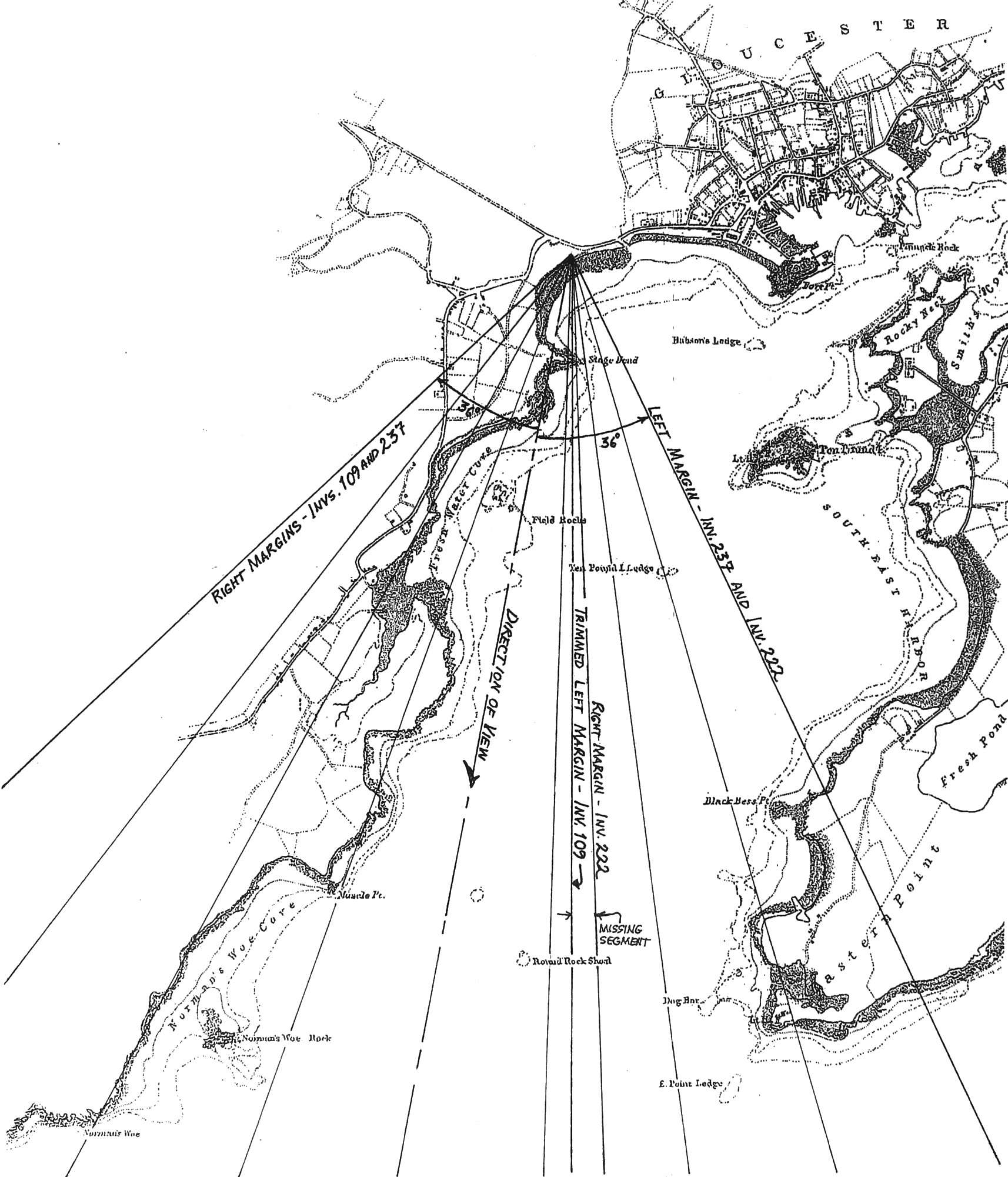
Viewpoint map showing Lane's location when making this drawing.
(inv.109 and inv. 222)
Provenance (Information known to date; research ongoing.)
the Artist, Gloucester, Mass.
Joseph L. Stevens, Jr., Gloucester, Mass.
Samuel H. Mansfield, Gloucester, Mass.
Cape Ann Museum, Gloucester, Mass., 1927
Marks & Labels
Marks: Inscribed upper left (in black ink): 100D [numbering system used by curator A. M. Brooks upon Samuel H. Mansfield's donation of the drawings to the Cape Ann Museum]
Exhibition History
No known exhibitions.Published References
Paintings and Drawings by Fitz Hugh Lane. Gloucester, MA: Cape Ann Historical Association, 1974., fig. 21.
Craig, James. Fitz H. Lane: An Artist's Voyage through Nineteenth-Century America. Charleston, SC: The History Press, 2006., fig. 93, p.135.
Commentary
The Cut was the canal dug to connect the Outer Harbor of Gloucester to the Annisquam River, so that vessels, especially those heavily laden with granite from the quarries, could avoid having to sail around the exposed eastern shoreline. In this drawing, Lane looks from the Cut across the beach of Steepbank Cove (named after the large house on the hill) towards Stage Head.
This drawing has long been suspected to be the sketch for Lane’s painting Stage Fort across Gloucester Harbor, 1862 (inv. 237). Recent examination of its third (left) sheet Untitled (inv. 222), previously unidentified as such, completes the image we see in the painting with Eastern Point, Stage Fort, and Fishermen’s Field (now Stage Fort Park) in near-perfect registration. Even the larger rocks lining the intertidal zone agree closely in shape and location. Only in the immediate foreground did Lane modify what he recorded in his drawing, adding vegetation, a wrecked New England boat, and driftwood.
The left edge of the drawing’s center sheet has been trimmed, leaving a gap 1-1/4 inches wide in the reassembled image. No trimming was done to the left sheet (Untitled (inv. 222)) whose reverse side was used for another drawing (Gloucester from Steepbank, c.1855 (inv. 125)). The inscription on the drawing of Steepbank Cove states that Lane made a painting for Mrs. Davidson (a good friend and the wife of his physician) after this drawing. A possible answer for the missing segment was that the center sheet’s overlapping left edge was cut off and later removed from the left sheet’s right edge, to which it had been glued.
The drawing was ruled vertically to create eight sections of equal width (five inches), and horizontally to create a horizon line over its full width. This preparation strongly suggests that a viewing aid, such as a camera lucida, or a viewing frame of unknown design, was used in the sketching process. The outlines and contours of rocks and terrain were lightly drawn, followed by denser treatment of the rocks and soil erosion along the shore line.
The drawing’s width (not counting end margins) is forty inches in its reconstructed state, with the eight 5-inch-wide sections. For the painting, the drawing was scaled up fifty percent with 7-1/2-inch-wide sections. Image height (sea and land only) has the same proportions in both drawing and painting. It would be useful to know if these lines could be seen in the painting, using infrared reflectography scanning (See essay by conservator Marcia Steele, "Conservation Techniques for Examination of Paintings").
–Erik Ronnberg