loading 
Fitz Henry Lane
HISTORICAL ARCHIVE • CATALOGUE RAISONNÉ • EDUCATIONAL RESOURCE
An online project under the direction of the CAPE ANN MUSEUM
An online project under the direction of the CAPE ANN MUSEUM
Catalog entry
inv. 105
Ten Pound Island in Gloucester Harbor
1850s Graphite on paper 9 5/16 x 11 3/16 in. (23.6 x 28.4 cm) Inscribed lower center: Ten Pound Island in / Gloucester Harbor / F.H.Lane / del.
|
Supplementary Images
Provenance (Information known to date; research ongoing.)
the Artist, Gloucester, Mass.
Joseph L. Stevens, Jr., Gloucester, Mass.
Samuel H. Mansfield, Gloucester, Mass.
Cape Ann Museum, Gloucester, Mass., 1927
Marks & Labels
Marks: Inscribed upper left (in red ink): 49 [numbering system used by curator A. M. Brooks upon Samuel H. Mansfield's donation of the drawings to the Cape Ann Museum]
Exhibition History
No known exhibitions.Published References
Paintings and Drawings by Fitz Hugh Lane. Gloucester, MA: Cape Ann Historical Association, 1974., fig. 14.
H. Travers Newton, Jr. "Fitz Henry Lane's Series Paintings of 'Brace's Rock': Meaning and Technique." Terra Foundation for American Art. Unpublished report., Ten Pound Island in Gloucester Harbor. ⇒ includes  text
text
Commentary
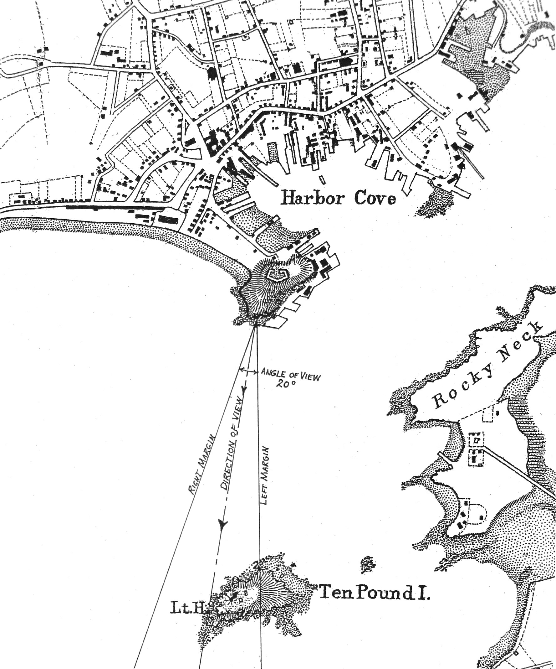
This drawing is very similar to Lane’s painting “Ten Pound Island, Gloucester” (Ten Pound Island, Gloucester, 1850s (inv. 17)) in terms of viewing point and direction of view. Like that image, Ten Pound Island is seen from the southeastern shore line of Fort Point, thanks to its accessibility to Lane after George H. Rogers built a complex of wharves there. The painting’s viewing point was at the midpoint of those wharves, but this drawing was made at their western end at the rocky southwest corner of Fort Point, as can be seen in the lower right corner. This viewing point shows Ten Pound Island Light and the keeper’s house at a slightly different - but noticeable – angle.
Ten Pound Island’s lighthouse was only a few feet distant from the southwest corner of the keeper’s house and connected to it by a very short causeway. Seen from Fort Point, the two would appear as a single structure. Atop the lighthouse, a dark angular structure points to the left. This is a weathervane with a “tell-tale” arrow inside which indicates the wind direction, saving the light keeper the trouble of going outdoors for this observation.
Ten Pound Island Light is needlessly confused with Eastern Point Light, as they differ in size and their relationships to their keepers’ houses. Unlike Ten Pound Island’s lighthouse, Eastern Point’s is distant from the keeper’s house and connected to it by a long causeway which traverses a hollow separating the two structures. Eastern Point Lighthouse is also larger and has a large fog bell in a steel framework close by.
A coasting schooner with a deck load of lumber (in addition to more lumber stowed in her hold) is anchored in “The Stream,” a deep anchorage lying between Harbor Cove, Ten Pound Island, and Rocky Neck. Harbor Cove was too shallow for deep-loaded ships, which had to anchor in The Stream and be partially unloaded by lighters before they could land the balance of their cargos at the wharves. This area was renamed “Deep Hole” in the late 19th century by a new generation of merchant shipping bringing salt to Gloucester and sailing away with salt fish for the rest of the world.
–Erik Ronnberg