An online project under the direction of the CAPE ANN MUSEUM
Mason, John
John Mason was a surveyor and cartographer who made several maps of Gloucester, Massachusetts. He was very active in town, speculating in land. He was the father of merchant Sidney Mason, and three other sons, including one named Alphonso who died when the steamship "Lexington"burned and another named John..
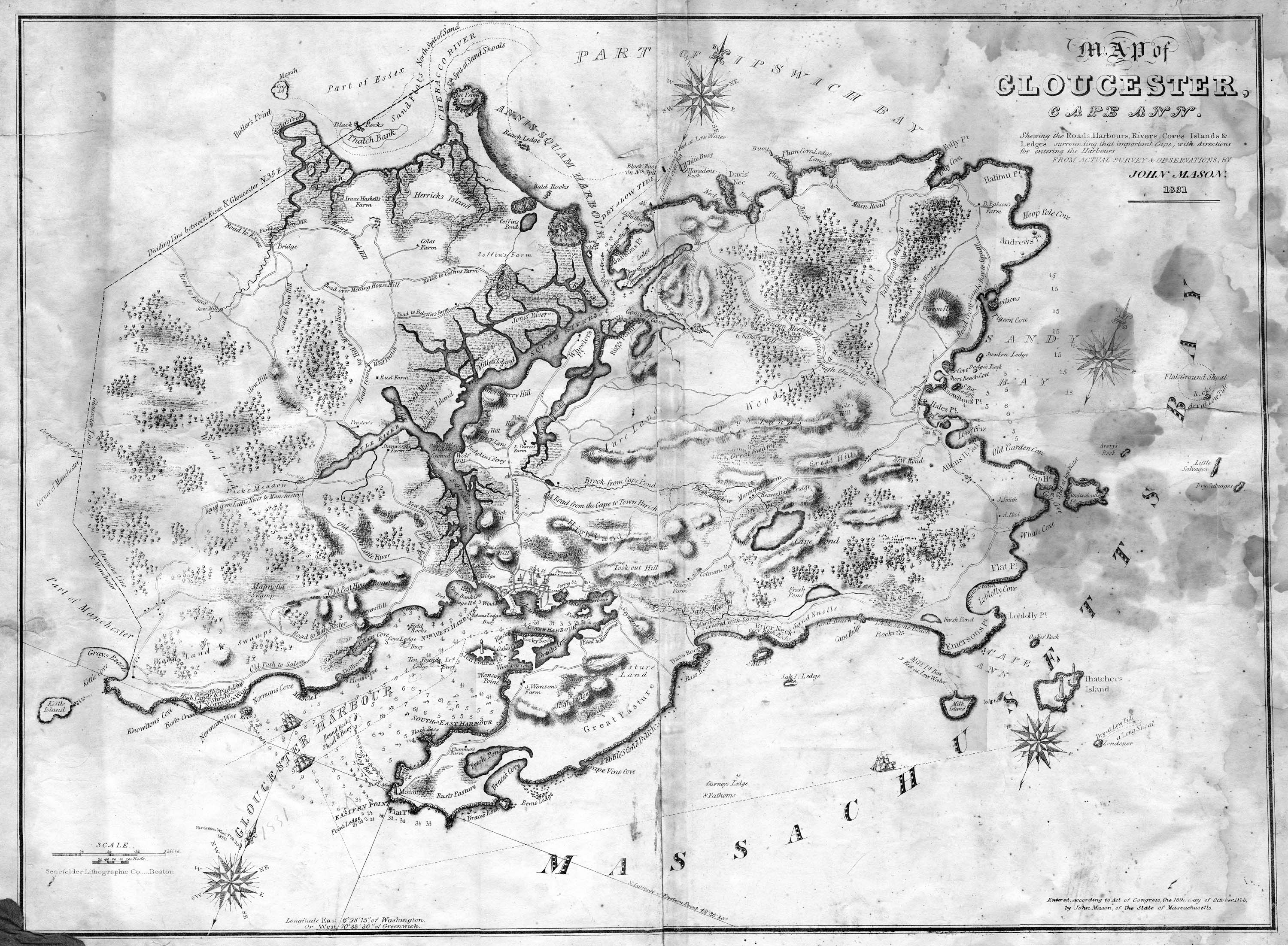
John Mason's maps included an 1830 colored map of Gloucester Harbor and a large 1831 map of the city of Gloucester. The state had mandated that each city and town produce a map of its lands, and Mason made that map for Gloucester. It is this map that was immediately mass-produced. Possibly, it was Lane who was hired to make colored copies for sale at W.E.P. Rogers' Gloucester Telegraph offices.
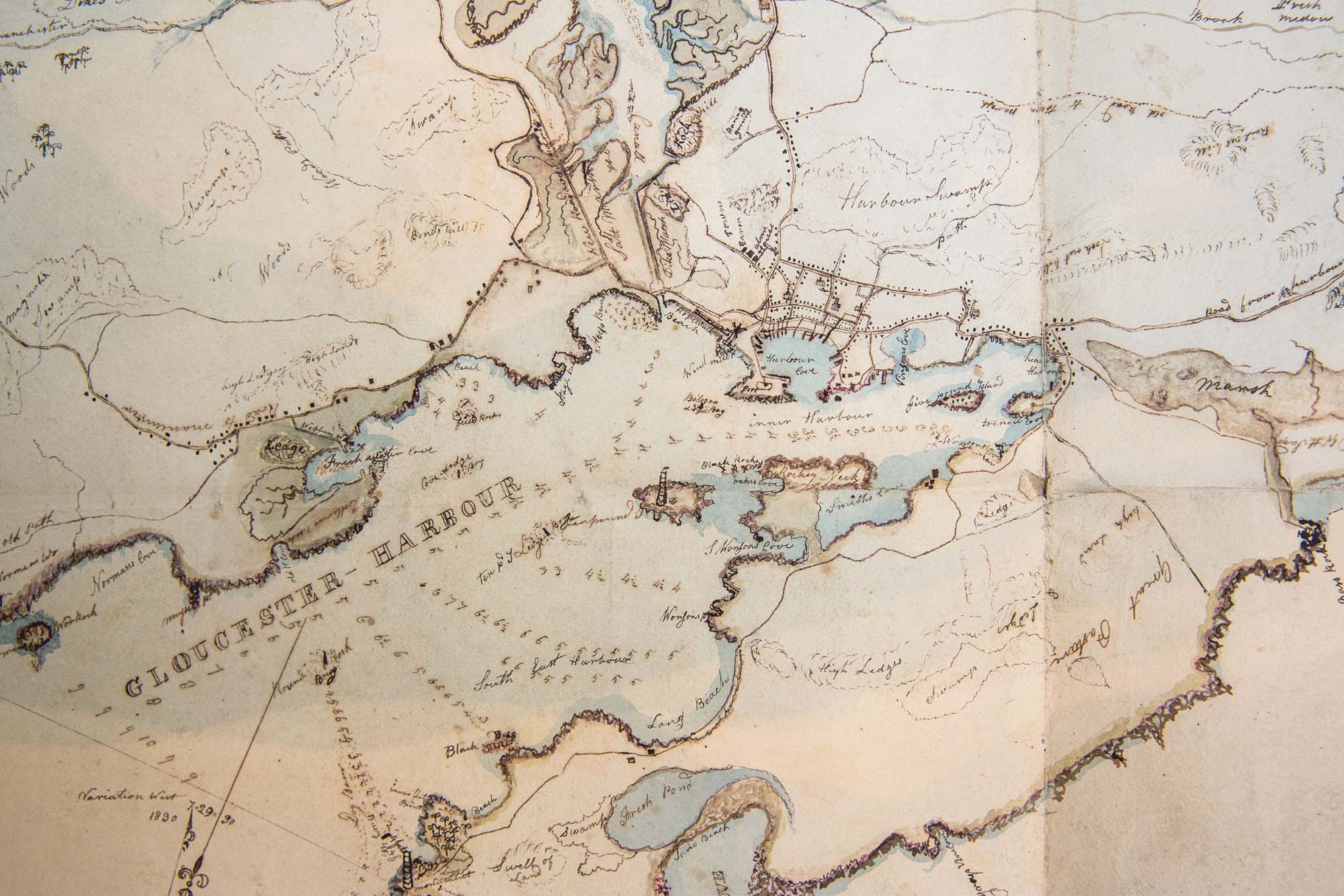
There are a few 'copies' of the 1834/35 Mason map—reproductions of a brown-and-white line-drawn copy showing all the houses and many of their owners, and indications of vessels in the harbor. It covers the area from Pavilion Beach to the Head of the Harbor on the north side: the main center of town. Mason may have made this map to keep track of his own purchases and sales of land downtown. However, he might have recorded his land deals on a detailed map of the harbor village that he made for some other purpose.
Related tables: Mason, Sidney »
Series Maps. v. 13: p. 17
SC1 / series 48X
Massachusetts Archives, Boston
View related Fitz Henry Lane catalog entries (1) »
Also filed under: Beacons / Monuments / Spindles » // Gloucester Harbor, Inner / Harbor Cove » // Gloucester Harbor, Outer » // Gloucester, Mass. - "Ten Pound Island Light » // Gloucester, Mass. – Eastern Point Light » // Maps » // Norman's Woe » // Pavilion (Publick) Beach » // Ropewalk »
Newspaper
Gloucester Telegraph: Map of Gloucester, p. 2, col. 4
American Antiquarian Society
John Mason drew map of Gloucester and it was sold in town by WEP Rogers. It was printed by Senefelder Lithographic Co. of Boston. The company was named after the inventor of lithography and begun by Abel Bowen & William S. Pendleton.
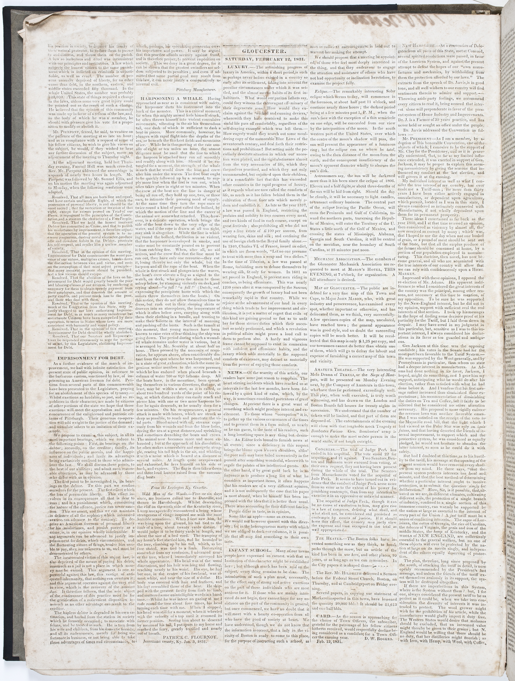
"MAP OF GLOUCESTER. – The public are indebted for a very fine map of this Town and Cape, to Major JOHN MASON, who, with great industry and perseverence, [sic] has examined every spot, whether importance or otherwise, and has delineated them, as we think, very successfully. A few specimen copies of the map, uncolored, have reached town; the general appearance was in good style, and no doubt the succeeding copies will be much better. It will be recollected that this map is only $1,25 per copy, and our townsmen cannot do better than obtain one of them, which will go to defray the labour and expense of furnishing a correct map of this town and vicinity."
Also filed under: Newspaper / Journal Articles »
Lithograph
28.5 x 21 in.
Cape Ann Museum Library & Archive
When Massachusetts decreed that each town be mapped, John Mason drew the map of Cape Ann in 1830. This drawing was sent to the Senefelder Lithographic Company of Boston (owned by William Pendleton) to be printed, and then sold in Gloucester by W.E.P. Rogers, whose Gloucester Telegraph of February 12, 1831 announced, "A few specimen copies of the map, uncolored, have reached the town" and that they cost $1.25. Perhaps this business arrangement between Pendleton and Rogers provided Lane with his introduction to Pendleton.
Also filed under: Folly Cove » // Good Harbor Beach / Bass Rocks » // Maps » // Meetinghouse Green » // Pendleton's, Lith. – Boston » // Salt Island » // Thacher Island »
Lithograph
24 x 38 in.
Gloucester City Archives
"Drawn on a scale of one hundred feet to an inch. By John Mason 1834–45 from Actual Survey showing every Lott and building then standing on them giving the actual size of the buildings and width of the streets from the Canal to the head of the Harbour & part of Eastern point as farr as Smith's Cove and the Shore of the same with all the wharfs then in use. Gloucester Harbor 1834–1835."
This section of the map shows the location of the Pavilion Hotel and ropewalk along the beach.
Also filed under: Maps » // Pavilion (Publick) Beach » // Pavilion Hotel » // Ropewalk » // Windmill »
Lithograph
24 x 38 in.
Gloucester City Archives
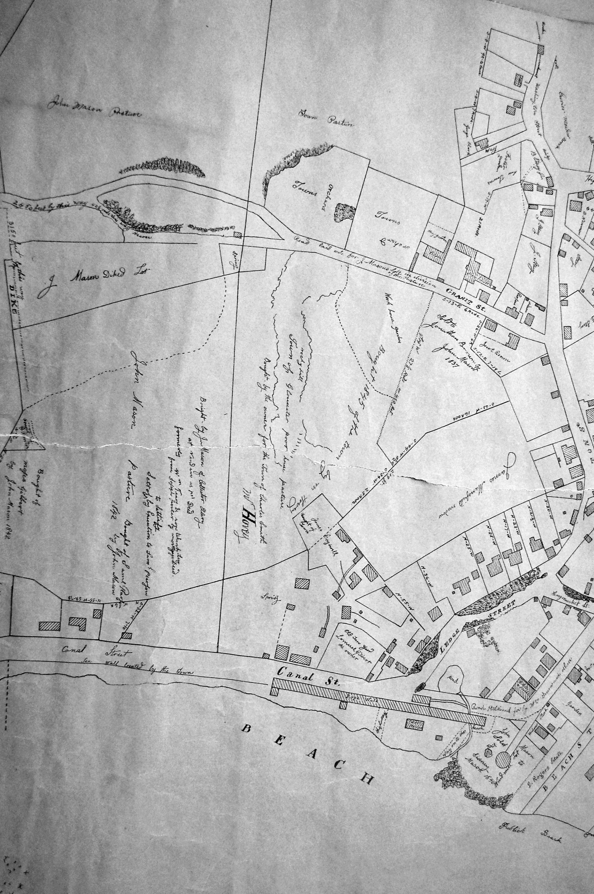
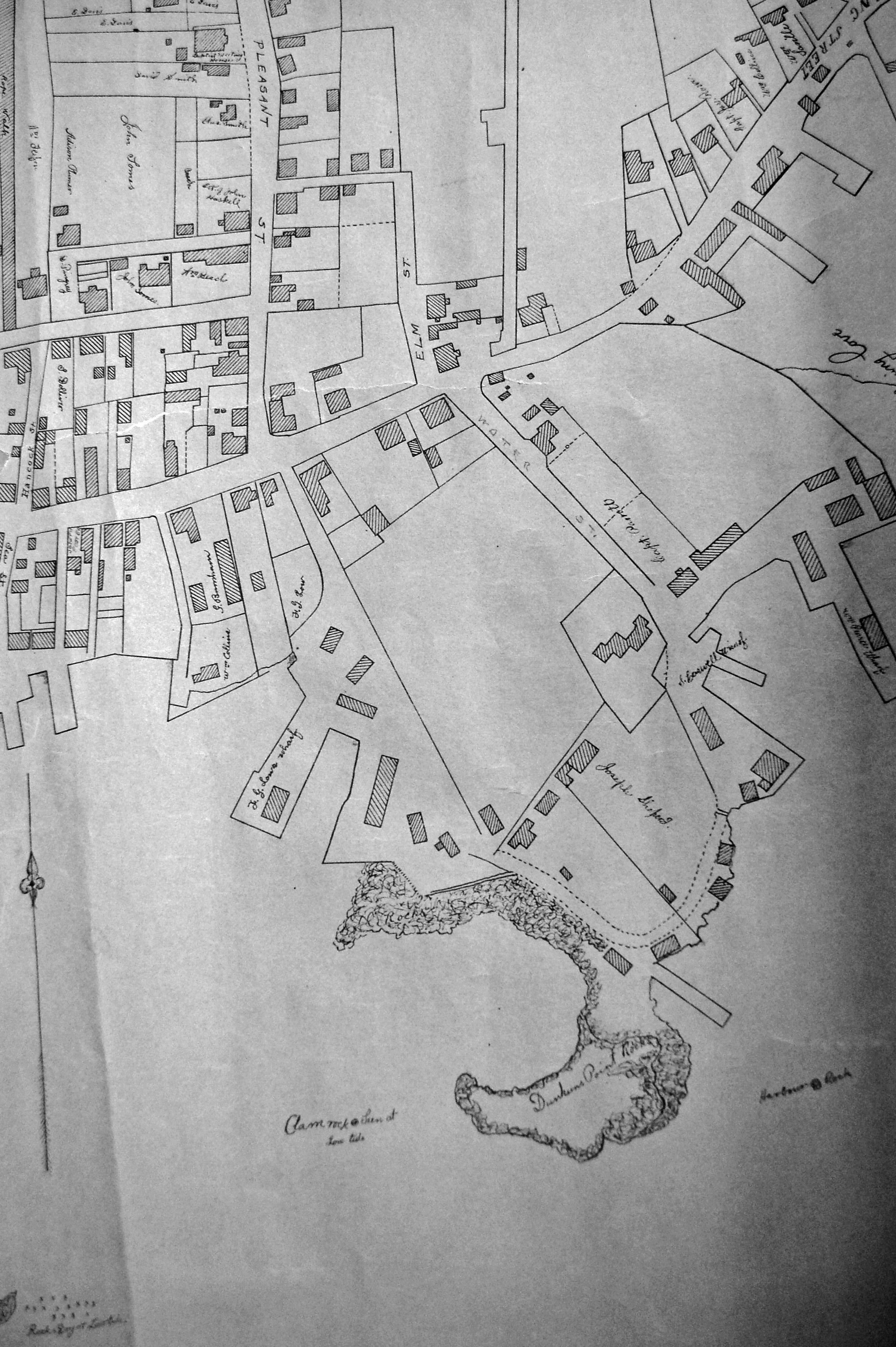
"Drawn on a scale of one hundred feet to an inch. By John Mason 1834–45 from Actual Survey showing every Lott and building then standing on them giving the actual size of the buildings and width of the streets from the Canal to the head of the Harbour & part of Eastern point as farr as Smith's Cove and the Shore of the same with all the wharfs then in use. Gloucester Harbor 1834–35."
This map shows the location of F. E. Low's wharf and the ropewalk. Duncan's Point, the site where Lane would eventually build his studio, is also marked.
The later notes on the map are believed to be by Mason.
Also filed under: Duncan's Point » // Gloucester Harbor, Inner / Harbor Cove » // Low (Frederick G.) wharves » // Low, Capt. Frederick Gilman » // Maps » // Residences » // Ropewalk » // Somes, Capt. John »
24 x 38 in.
Gloucester City Archives
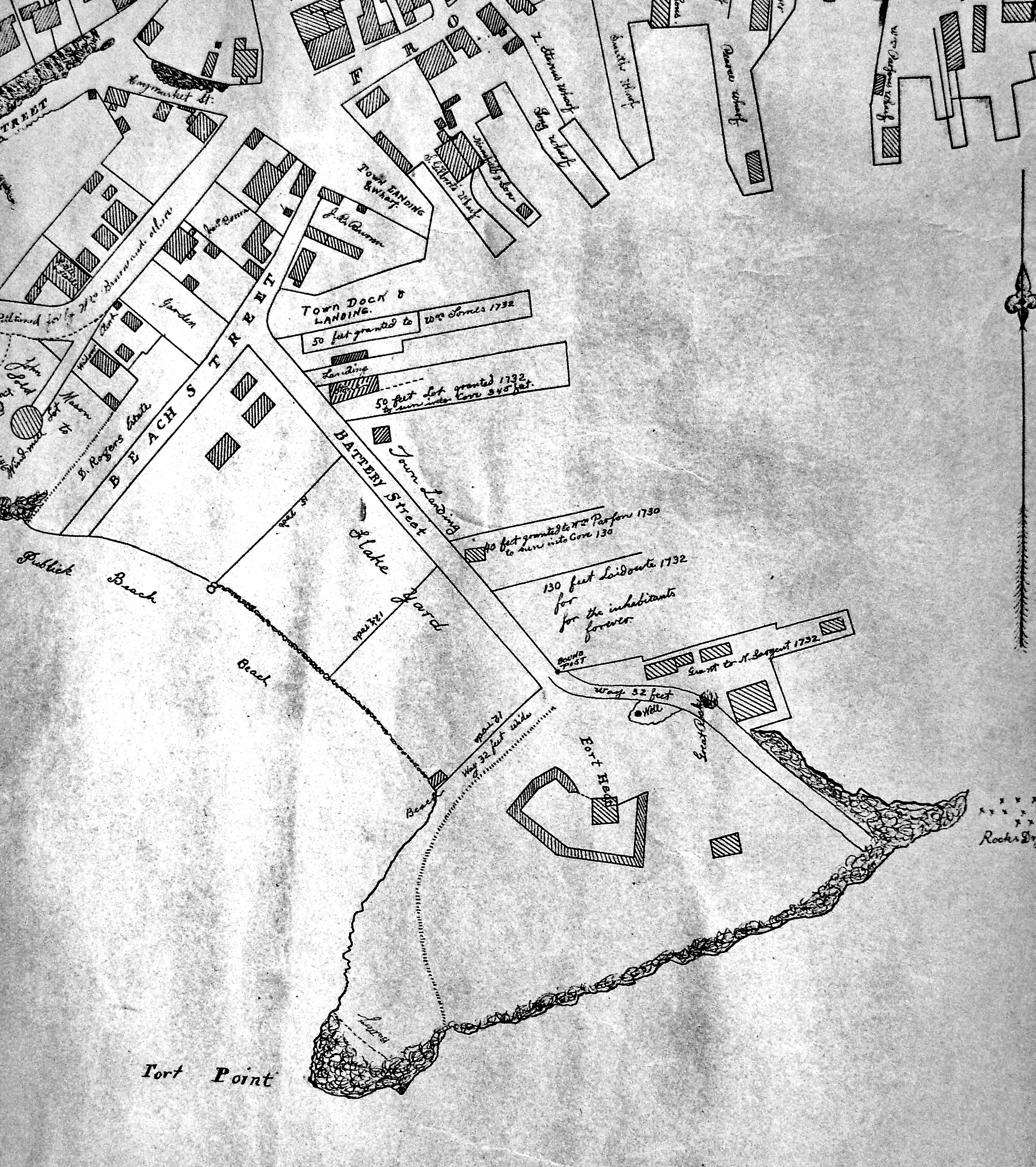
"Drawn on a scale of one hundred feet to an inch. By John Mason 1834–45 from Actual Survey showing every Lott and building then standing on them giving the actual size of the buildings and width of the streets from the Canal to the head of the Harbour & part of Eastern point as farr as Smith's Cove and the Shore of the same with all the wharfs then in use. Gloucester Harbor 1834–35."
This map is especially useful in showing the Fort.
Also filed under: Flake Yard » // Fort (The) and Fort Point » // Maps » // Pavilion (Publick) Beach » // Town / Public Landings »