An online project under the direction of the CAPE ANN MUSEUM
Historical Materials: Maine Locales & Buildings
Historical Materials » Maine Locales & Buildings » Bear Island
You have navigated to this pages from catalog entry: Near Southeast View of Bear Island, 1855 (inv. 135)
Bear Island
View related Fitz Henry Lane catalog entries (4) »
Bear Island, more probably Bare Island, on the east side of Somes Sound, Mount Desert, marks the entrance into Northeast Harbor. William Moore of Sutton Island purchased Bear Island in 1836, and probably used the island for grazing sheep. A conveyance in 1884 states that the 8-acre island had a barn with a hay. William Moore sold 2 acres including shore access and well rights to the US government in 1838, and a light was built at the expense of $3000 in 1839. John G Bowan was the first keeper, and he had a family of 5 in 1840. Fire destroyed the keeper's dwelling in 1852 and it was rebuilt in 1853. The harbor was "a general rendezvous for coasting vessels and fishermen in bad weather" and "a focal point for all vessels passing through the in shore thoroughfare…"
– Mark Honey
References:
Charles B. McLane and Carol Evarts McLane. Islands of the Mid-Maine Coast: Penobscot Bay, vol. 1, revised ed. (Gardiner, ME: Tilbury House Publishers; in association with the Island Institute, Rockland, ME, 1982), 335.
Charles B. McLane and Carol Evarts McLane. Islands of the Mid-Maine Coast: Mount Desert to Machias Bay, vol. 2 (Falmouth, ME: The Kennebec River Club Press, 1989).
Related tables: Northeast Harbor, Maine – Bear Island Lighthouse » // Somes Sound »
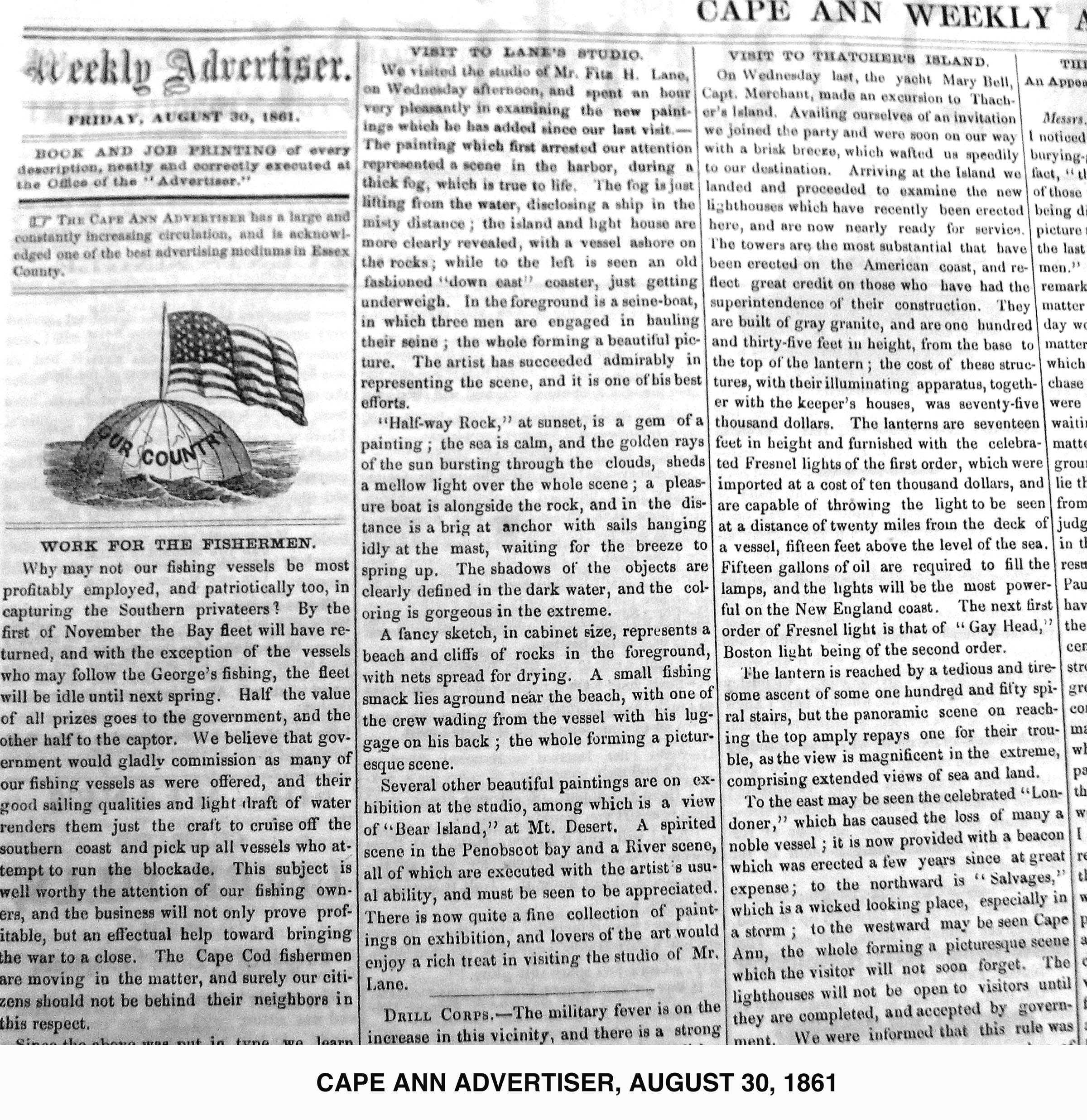
Newsprint
Cape Ann Advertiser
Cape Ann Museum Library & Archive
"VISIT TO LANE'S STUDIO.
We visited the studio of Mr. Fitz H. Lane, on Wednesday afternoon, and spent an hour very pleasantly in examining the new paintings which he has added since our last visit. – The painting which first arrested our attention represented a scene in the harbor, during a thick fog, which is true to life. The fog is just lifting from the water, disclosing a ship in the misty distance; the island and light house are more clearly revealed, with a vessel ashore on the rocks; while to the left is seen an old fastioned 'down east' coaster, just getting underweight. In the foreground is a seine-boat, in which three men are engaged in hauling their seine; the whole forming a beautiful picture. The artist has succeeded admirably in representing the scene, and it is one of his best efforts.
'Half-way Rock,' at sunset, is a gem of a painting; the sea is calm, and the golden rays of the sun bursting through the clouds, sheds a mellow light over the whole scene; a pleasure boat is alongside the rock, and in the distance is a brig at anchor with sails hanging idly at the mast, waiting for the breeze to spring up. The shadows of the objects are clearly defined in the dark water, and the coloring is gorgeous in the extreme.
A fancy sketch, in cabinet size, represents a beach and cliffs of rocks in the foreground, with nets spread for drying. A small fishing smack lies aground near the beach, with one of the crew wading from the vessel with his luggage on his back; the whole forming a picturesque scene.
Several other beautiful paintings are on exhibition at the studio, among which is a view of 'Bear Island,' at Mt. Desert. A spirited scene in the Penobscot bay and a River scene, all of which are executed with the artist's usual ability, and must be seen to be appreciated. There is now quite a fine collection of paintings on exhibition, and lovers of the art would enjoy a rich treat in visiting the studio of Mr. Lane."
Also filed under: Newspaper / Journal Articles » // Studio Descriptions »
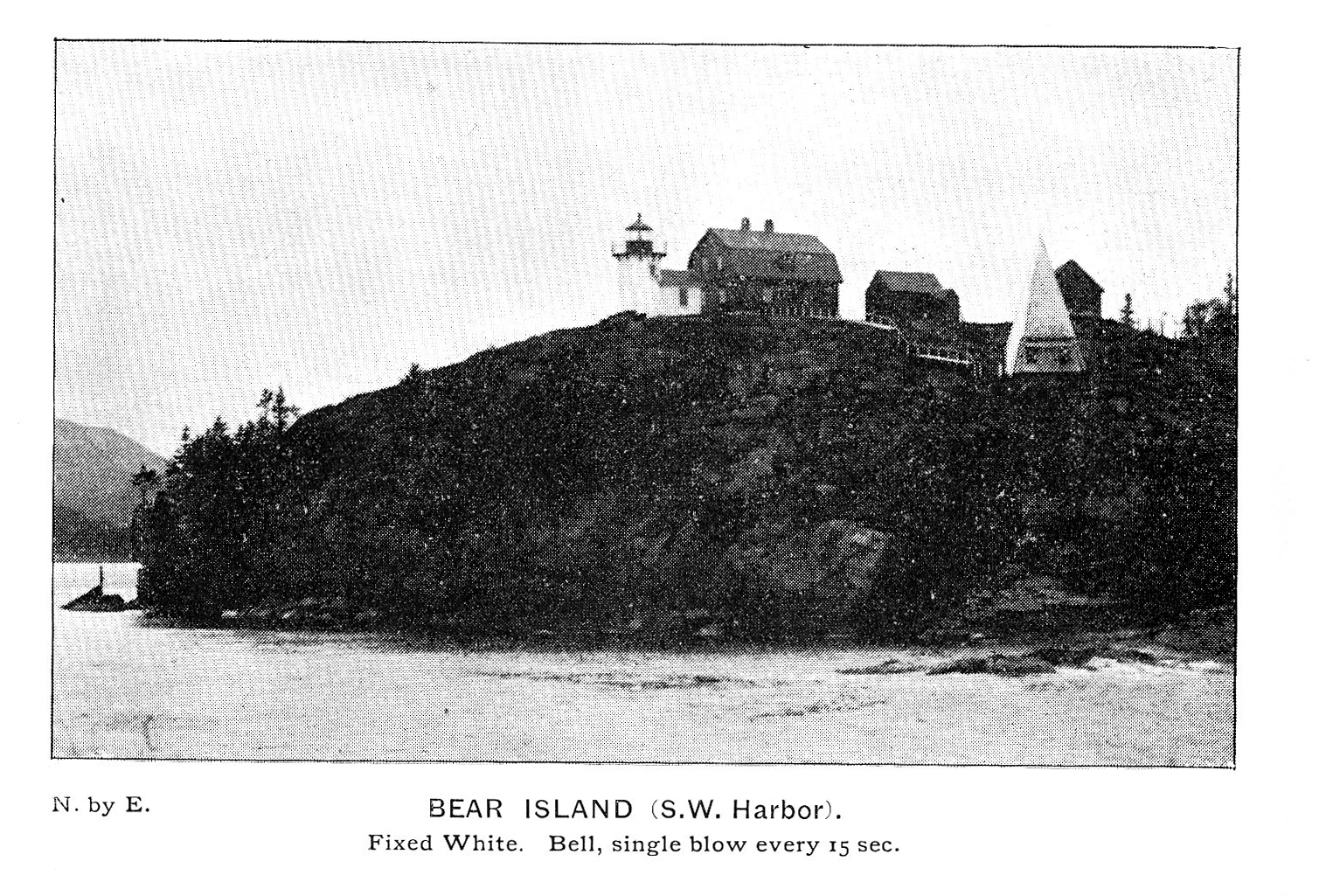
Photograph
From The Illustrated Coast Pilot with sailing directions. The Coast of New England from New York to Eastport, Maine including Bays and Harbors, published by N.L. Stebbins, Boston, Mass.
Also filed under: Northeast Harbor, Maine – Bear Island Lighthouse »

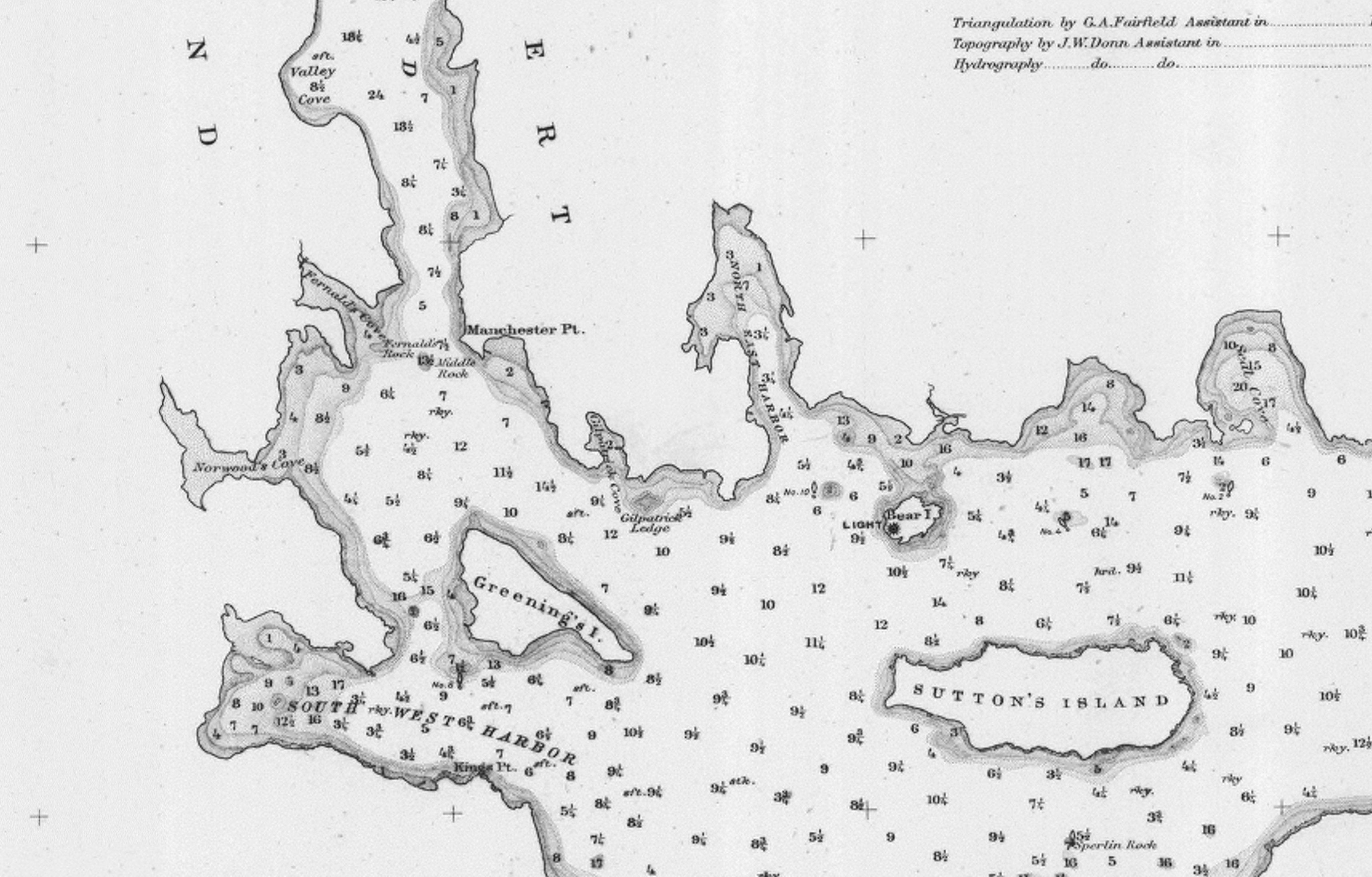
Illustration
"U.S. Coast Pilot, Atlantic Coast, Parts I–II." First edition. Published by Washington GPO, 1891
Folded plate between pp. 62 and 63
Also filed under: Maps » // Mount Desert Island & Rock » // Northeast Harbor, Maine – Bear Island Lighthouse » // Southwest Harbor »